BIRM-166’s Sedge Basin31119 BCE
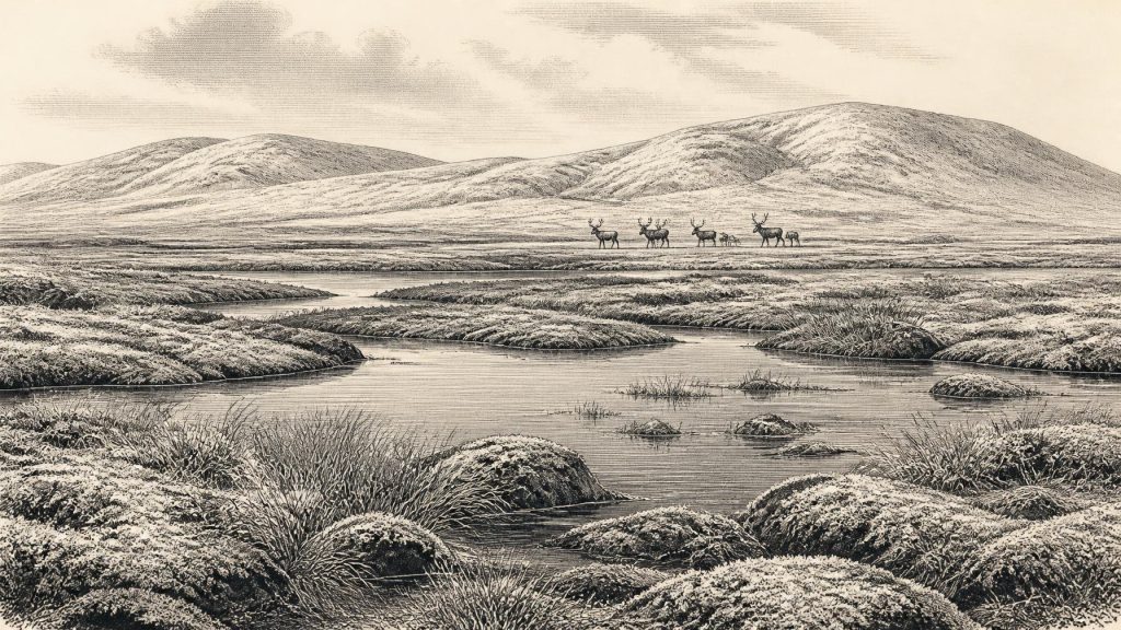
Around 31,119 BCE, Ireland lay within the fluctuating later Marine Isotope Stage 3, when ice advanced and retreated. Derryvree in County Fermanagh preserves freshwater silts between glacial tills, recording a cold treeless wetland of sedges, mosses and pools during an ice-free interval. Its radiocarbon range includes this date but cannot establish precise conditions or events. Cork cave deposits show mammoths, reindeer, giant deer and predators inhabited changing open landscapes, although their chronology is imperfect. Possible cut marks on a reindeer bone suggest human activity, not settlement. Lower sea levels may have enabled faunal and human access, though routes remained uncertain.
Dateline
The label 31,119 BCE is a modern way of pointing to a remote point in the Late Pleistocene, not a year from which Ireland preserves an event-by-event history. It equates roughly to 33,068 years before AD 1950, the conventional “present” used in radiocarbon work. That arithmetic is useful for orientation, but it must not be mistaken for calendar precision. No Irish settlement surface, hearth, burial, ruler, battle or treaty can be assigned to this particular year. The responsible account is instead one of climatic change, glacial movement, plants, animals and the rare sediments through which archaeologists and Quaternary scientists reconstruct a broad interval.
In archaeological terms, this falls within the later part of Marine Isotope Stage 3, a fluctuating phase of the last Ice Age, and within the Irish Midlandian glaciation. Ireland was not yet at the maximum extent of the final British–Irish Ice Sheet, but neither was it a stable, uniformly ice-free country. Ice growth, retreat and local persistence varied greatly by region. The familiar map of Ireland, its modern coastline, wooded vegetation and settled countryside are therefore all misleading starting points for imagining this time.
A Date Within a Range
The most illuminating Irish evidence comes from Derryvree, near Maguiresbridge in County Fermanagh. Roadworks there exposed a sequence within a drumlin: glacial till below, organic freshwater silts and fine sands in the middle, and another thick till above. Till is the unsorted mixture of clay, stones and other debris deposited directly by glacier ice. The order of these layers is exceptionally valuable. It demonstrates that ice had occupied the locality, that an interval followed in which water, sediment and living things accumulated, and that a later advance of ice buried and preserved that short-lived landscape.
Organic material from this freshwater series produced the radiocarbon determination Birm-166, conventionally dated to 30,500 radiocarbon years BP, with an uncertainty of more than a millennium. Radiocarbon years are not calendar years: concentrations of atmospheric carbon-14 have changed through time, and measurements must be calibrated against independently dated records. Published calibration places the Derryvree material broadly at about 36,900–31,700 calibrated years BP, approximately 34,950–29,750 BCE. The requested year lies inside that wide span, but cannot be attached to a particular sediment layer, plant, insect, animal or season within it.
This limitation is central rather than merely technical. Derryvree is evidence for conditions during a broad middle-Midlandian interval; it is not a photograph of Ireland in 31,119 BCE. Nor can one wetland in Fermanagh stand for every valley, upland or coastal plain. Nevertheless, it is among the strongest surviving Irish records for understanding what an ice-free or lightly glaciated locality could support during this unsettled age.
The Freshwater World Beneath the Drumlin
The Derryvree deposits indicate cold, open country rather than forest. Their plant and insect evidence has been interpreted as a treeless tundra or muskeg-like environment: wet, peaty ground and shallow freshwater amid low vegetation, with severe winter conditions and a brief productive season. Mosses, sedges, grasses, herbs, dwarf shrubs and aquatic plants could exploit saturated ground and sheltered pools. Such evidence supports the existence of a freshwater basin and surrounding wetland; it does not justify imagining a uniform blanket of tundra across the whole island.
Freeze–thaw would have shaped everyday physical conditions more decisively than any human activity detectable in the record. Water could collect in hollows during thaws; frost could heave soils, disrupt drainage and limit tree growth. The contrast between the organic silts and the tills enclosing them records a profound regional rhythm: a landscape briefly able to sustain plants, invertebrates and grazing animals, then overtaken or sealed by renewed glacial action. Later ice destroyed much evidence elsewhere, which is one reason Derryvree’s buried sequence matters so greatly.
The wider ice-sheet history remains an active research field. Recent British–Irish Ice Sheet reconstructions show that advance was asynchronous: different sectors grew, reached their greatest extents and retreated at different times. A broad ice-sheet maximum came later, principally during the interval after about 27,000 calibrated years BP, with a reconstructed maximum ice volume around 23,000 years BP. At roughly 33,000 calibrated years BP, therefore, Ireland should not be described simply as either wholly frozen or wholly open. The better description is a geographically varied cold-stage landscape whose ice margins and habitable patches shifted over long timescales.
Animals in a Changing Corridor
Caves in the Blackwater valley of County Cork, especially Castlepook or Mammoth Cave near Doneraile, provide another important but differently formed archive. The cave assemblage includes remains of woolly mammoth, reindeer, giant deer, brown bear, wolf, Arctic fox, lemmings and spotted hyaena. These are compelling evidence that Ireland was repeatedly reached by animals associated with cold, open environments during the last glacial cycle. They also show that the island’s Pleistocene fauna was far richer and less familiar than the fauna of historical Ireland.
Care is needed, however. Many Castlepook bones were recovered in early excavations, from deposits disturbed by excavation, cave processes and later activity. The remains do not form a neatly sealed community living together on one day, or even necessarily in one century. Improved radiocarbon pretreatment and redating have revised several ages, pushing parts of the MIS 3 fauna significantly earlier than older determinations suggested. The evidence permits a broad conclusion—large herbivores and their predators used Irish landscapes before the Last Glacial Maximum—but not a precise reconstruction of which animals stood beside the Derryvree wetland in 31,119 BCE.
Reindeer are especially relevant to the image of this landscape because they were adapted to open northern environments and occur in the Irish Pleistocene record. Mammoths and giant deer imply substantial forage in at least some accessible areas; hyaenas, wolves and bears indicate carnivore and scavenger communities. Yet each fossil is evidence of an animal’s presence, not a census. The absence of a species at a site may reflect preservation, collection history or a particular habitat as much as genuine absence from Ireland.
People: A Question, Not a Society
No securely excavated Irish camp, stone-tool assemblage, dwelling, grave or human bone currently allows historians to describe a resident human community at this date. Consequently there is no evidential basis for political affairs, diplomacy, named groups, religious institutions, formal learning or established trade networks in Ireland around 31,119 BCE. It would be inappropriate to invent chiefdoms, hunting territories, ritual practice or a calendar merely because modern humans lived elsewhere in Europe.
A reindeer femur from Castlepook has nevertheless made this period an important archaeological question. A mark on the bone has been interpreted as made by a sharp stone tool, and the animal has been reported as dating to around 33,000 years ago. If that taphonomic interpretation is upheld, it would indicate human handling of a reindeer in Ireland during MIS 3 and would greatly extend the island’s known human story. But the bone comes from a legacy collection rather than a modernly excavated occupation floor. A radiocarbon result dates the animal’s death, while identifying a mark as a cut from butchery is a separate judgement. The find is therefore a significant claim of possible human activity, not proof of a settled population or an event in this exact year.
Even a confirmed butchery episode would imply only a brief human presence: perhaps mobile foragers crossing a cold landscape, exploiting a carcass and moving on. It would not demonstrate permanent settlement, family continuity, exchange systems or cultural traditions within Ireland. The securely evidenced human record becomes much clearer only far later, after the climatic and geographical transformations of the terminal Pleistocene.
Coasts, Connections and Silence
Lower global sea levels altered the outlines of north-western Europe, but precise routes between Ireland, Britain and the continent remain debated and changed through time. Geological work has challenged simple assumptions of a long, continuous Irish land bridge, while more recent palaeogenetic work on cave sediments supports faunal connectivity with wider Eurasian populations before the Last Glacial Maximum. For this date, the safest conclusion is that animals—and possibly people—had opportunities to reach Ireland during changing glacial and sea-level conditions. The precise route, duration and character of every connection are not established.
There can be no demonstrated Irish economy in the later historical sense. No fields, livestock, houses, boats, mines, traded artefacts or managed herds are known from this horizon. The only securely visible “economy” is ecological: plants converting a short growing season into forage; herbivores ranging through open ground; carnivores and scavengers following prey and carrion; and water concentrating life in wetland niches. If people were present, their subsistence would have been dependent on this unstable environmental mosaic, but the Irish record does not yet reveal its details.
Thus the history appropriate to 31,119 BCE is neither empty nor a tale of lost kingdoms. It is the history of a sedge-fringed freshwater basin at Derryvree, sealed between episodes of glaciation; of cold-adapted mammals known from caves in Cork; and of scientific methods that convert fragmentary deposits into carefully bounded knowledge. Ireland at this point was a place of environmental possibility under pressure: locally capable of supporting life, but vulnerable to the returning ice that would conceal much of its evidence for tens of millennia.
Primary Sources
- A Middle Midlandian Freshwater Series at Derryvree, Maguiresbridge, County Fermanagh, Northern Ireland
- Figure 6.— The Subdivision of the Quaternary Period in Ireland
- Irish Association for Quaternary Studies Field Guide
- A Reconsideration of the Radiocarbon Dating of the Marine Isotope Stage 3 Fauna from Southern Ireland
- The Irish Quaternary Fauna Project
- Pleistocene Vertebrates in the British Isles
- Occurrence of Mammalia Relicts at Site Castlepook Cave
- Growth and Retreat of the Last British–Irish Ice Sheet, 31,000 to 15,000 Years Ago: the BRITICE-CHRONO Reconstruction
- Growth and Retreat of the Last British–Irish Ice Sheet, 31,000 to 15,000 Years Ago: the BRITICE-CHRONO Reconstruction
- Dimensions and Chronology of the Last Ice Sheet in Western Ireland
- Trimlines, Blockfields and the Vertical Extent of the Last Ice Sheet in Southern Ireland
- Deglacial Rates and Controls for BIIS Western Margin
- Exploring Controls of the Early and Stepped Deglaciation on the Western Margin of the British–Irish Ice Sheet
- Dating Constraints on the Last British-Irish Ice Sheet: a Map and Database
- The IntCal20 Northern Hemisphere Radiocarbon Age Calibration Curve (0–55 kcal BP)
- Marine20—The Marine Radiocarbon Age Calibration Curve (0–55,000 cal BP)
- The Problem of a Late Quaternary Landbridge Between Britain and Ireland
- European Phylogeography of the Common Frog (Rana temporaria): Routes of Postglacial Colonization into the British Isles, and Evidence for an Irish Glacial Refugium
- New Insights on the Fauna of Ireland's Younger Dryas and Early Holocene from Alice & Gwendoline Cave
- Castlepook Cave, Castlepook South, County Cork: Excavation Report 2022
- Heritage Artefacts of County Cork
- Sedimentary Ancient DNA Reveals Late Pleistocene Faunal Connectivity Between Ireland and Eurasia
- Freshwater Organic Deposits and Stratified Sediments Between Early and Late Midlandian (Devensian) Till Sheets, at Aghnadarragh, County Antrim, Northern Ireland
- The Late Quaternary History of East-Central Ireland
