Derryvree’s Intertill Witness31104 BCE
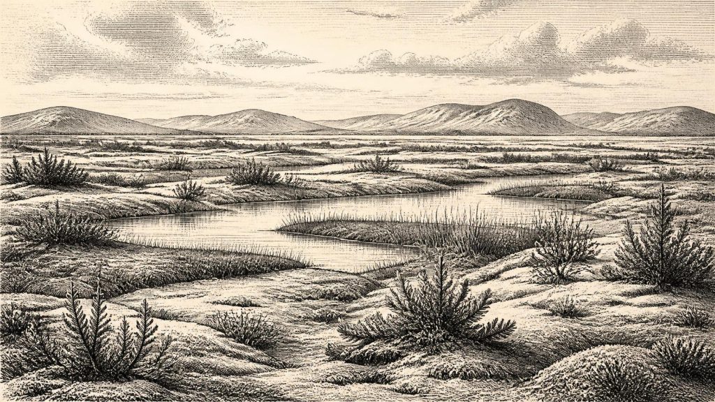
31,104 BCE is a modern filing date, not a datable Irish event. Derryvree, County Fermanagh, preserves freshwater silts and organic remains between glacial tills, indicating an ice-free late-MIS-3 interval of cold, open, waterlogged tundra with pools, sedges, insects and sparse shrubs. It disproves continuous island-wide glaciation but cannot define conditions across Ireland. Castlepook Cave, County Cork, contains time-averaged remains of mammoth, reindeer, giant deer and predators, demonstrating intermittent ecological connections with north-west Europe. A possibly cut-marked reindeer bone suggests brief Upper Palaeolithic human activity, but proves neither settlement nor hunting. Together, these fragmentary archives document dynamic environments, not an history.
Dateline
31,104 BCE is a modern filing date, not a recoverable Irish year. No written record, named community, dated settlement floor or archaeological sequence can identify an event in Ireland within this particular year. In calendar terms it lies about 33,050 years before the AD 1950 reference point conventionally used in radiocarbon dating, during the later part of the last Ice Age’s Marine Isotope Stage 3. The responsible history of this moment must therefore be told through broad calibrated ranges, buried deposits and cautious comparison, rather than through an invented annual chronicle.
The closest major Irish environmental record is the Derryvree freshwater deposit near Maguiresbridge, County Fermanagh. Its conventional radiocarbon result, BIRM-166, was 30,500 radiocarbon years BP, with a large uncertainty. Calibration converts this into a much broader calendar range, published at roughly 36,900–31,700 calibrated years BP; later regional modelling places the relevant ice-free evidence around 33,500 ± 1,200 years ago. The notional year considered here falls within that wide horizon. It does not date a particular pool, plant, animal or human action to 31,104 BCE.
A Wetland Between Ice Advances
Derryvree was revealed in a road cutting through a drumlin in 1969. The sequence was remarkable: a lower till, a middle bed of freshwater silts, fine sands and organic material, and a later till above. Till is unsorted sediment laid down by glacier ice. The order of these deposits provides firm evidence for a profound local change: ice had affected the district; water, vegetation and sediment then accumulated in an ice-free interval; and renewed glacial conditions eventually buried and preserved the wetland.
The biological remains are the real witness. Pollen, plant macrofossils, mosses and insect remains indicate open, cold and waterlogged ground. Grasses and sedges were important, while plants associated with chilly wet habitats, including bogbean, water-milfoil, mountain avens and lesser clubmoss, have been reported from the sequence. Juniper and dwarf willow probably occupied better-drained patches. The insects include terrestrial and aquatic forms, supporting the picture of shallow pools, mossy margins and plant-rich water rather than a sterile frozen surface.
This was not the familiar wooded Ireland of later prehistory. Trees were absent locally or too scarce to form forest. The older term muskeg is often used for the reconstructed landscape: saturated, peaty tundra-like ground broken by pools and sedge beds. It should not be mistaken for a complete island-wide landscape map, still less for an exact season in an exact year. Derryvree records one basin and its catchment. Yet it securely demonstrates that at some point in this broad late-MIS-3 interval, south Fermanagh supported freshwater life between episodes of glaciation.
Cold Country, Not Permanent Ice
The wider setting was unstable. Ireland was approaching the major growth of the last British–Irish Ice Sheet, but had not yet reached the better-documented maximum that came later, principally between about 27,000 and 23,000 years ago in different sectors. Modern reconstructions show that ice-sheet build-up, maximum extent and retreat were asynchronous: an advancing margin in one region did not necessarily mean that every part of Ireland was simultaneously buried beneath a uniform ice cover.
Derryvree is therefore important corrective evidence. It rules out the simplest picture of continuous island-wide glaciation throughout the period. It does not establish that all Ireland was habitable, ice-free or connected by dry land at 31,104 BCE. Uplands, coasts, lowlands and the surrounding sea shelf responded differently to climate and topography. Ice, seasonal snow, frost-shattered ground and shifting drainage could all have constrained movement. Lower global sea levels altered the geography around Ireland, but the surviving Irish evidence cannot specify a reliable land route, a crossing season or whether people used one.
The later ice sheet also helps explain why the record is so fragmentary. Repeated glacial erosion, redeposition and burial transformed older landscapes; any exposed campsites, hearths or tracks were especially vulnerable. The absence of a known settlement is consequently not simple proof that no people ever entered Ireland. But it is equally not a licence to populate the island with imagined bands of hunters. The evidence establishes a changing environment more securely than it establishes a human population.
Castlepook’s Uneven Fauna
County Cork provides the principal complementary archive. Castlepook Cave, near Doneraile and also called Mammoth Cave, yielded Ireland’s richest known assemblage of Late Pleistocene vertebrate remains. Its old excavations recovered bones of woolly mammoth, giant deer, reindeer, brown bear, wolf, Arctic fox, lemmings, mountain hare and spotted hyaena. Taken together, these finds demonstrate that Ireland was repeatedly ecologically connected to the wider north-west European world during parts of the Ice Age. Large grazing animals and their predators or scavengers could reach, or survive in, parts of the island.
That conclusion requires an important qualification. Castlepook is not a single occupation layer or a contemporary wildlife census. Its passages accumulated remains over a long period, through natural deaths, carnivore activity, water movement, collapse and disturbance. Early twentieth-century excavation removed much material before modern stratigraphic recording was possible. Direct re-dating has also shown that several older bone dates understated the true ages by thousands of radiocarbon years. Individual remains demonstrate the presence of species at broad times; they do not prove that every listed animal encountered every other animal, or lived beside Derryvree in this particular year.
Nevertheless, the fauna gives scale and texture to the open landscapes suggested by Fermanagh’s wetland. Reindeer are well suited to mobile life in sparse, seasonal grazing country. Mammoth and giant deer imply sizeable herbivore habitats at least intermittently. Hyaenas, wolves and foxes show that carrion, predation and scavenging formed part of a more complex food web. This was not a settled agricultural landscape with livestock and cleared fields. It was a fluctuating cold-stage environment in which animal movements would have followed changing vegetation, snow cover, water and ice margins.
The Human Question
One Castlepook object raises the possibility of an exceptionally early human presence. A reindeer femur in the historic collection bears a deep incision interpreted by zooarchaeologist Ruth Carden as a mark made by a sharp stone tool during butchery. County Cork heritage material places the bone at about 31,000 BCE, broadly close to this article’s nominal horizon. If that interpretation is accepted, it is evidence that people processed a reindeer in Ireland during the Upper Palaeolithic, far earlier than the securely established post-glacial settlement record.
The distinction between observation and interpretation is essential. The bone and its mark are physical evidence. Identifying the mark as stone-tool damage is a specialist taphonomic judgement. Inferring hunters, a seasonal reindeer pursuit, a route from Britain, or a resident Irish population goes further still. No stone tool, hearth, shelter, human bone, repeated occupation surface or securely excavated kill site is known from Castlepook for this period. The femur may have been processed elsewhere and later transported to the cave by carnivores or natural processes. It cannot show whether people killed the animal, scavenged it, camped nearby or returned.
Accordingly, permanent settlement cannot responsibly be claimed for Ireland in 31,104 BCE. A brief visit by highly mobile people is possible if the cut-mark diagnosis is correct. Beyond that, the evidence is silent about language, family structure, clothing, social rank, ritual or technology. Upper Palaeolithic communities elsewhere in Europe used sophisticated stone implements, fire, tailored clothing and long-distance social networks, but those comparisons describe what may have been possible, not what has been demonstrated in Ireland.
No Polities, No Diplomacy
There are no identifiable Irish political affairs for this date: no kingdom, tribe, chief, boundary, treaty or battle. There is likewise no evidence for formal religion, shrines, monuments, learning institutions or exchange systems. It would be misleading to invent them merely because the article is arranged around a numbered year. If people did enter Ireland, their economy may have included the opportunistic use of animal resources such as meat, hide, marrow, sinew and bone; that remains an inference from the possible butchery mark and the wider animal record, not a documented Irish economy.
For everyday life, the strongest evidence concerns non-human life. Short growing seasons, frost, exposed ground and shifting water limited what plants and animals could do. Yet Derryvree’s pools and mossy wetlands show that cold conditions did not mean biological emptiness. Freshwater, sedges, herbs, insects and small patches of sheltered vegetation created usable habitats, while the Castlepook record shows that larger mammals periodically formed part of Ireland’s wider ecological world.
An Archive Rather Than an Anniversary
The most meaningful development around 31,104 BCE was not a recorded human deed but a changing landscape. Derryvree preserves a rare interval when life accumulated in a cold Fermanagh wetland before later ice sealed it beneath till. Castlepook preserves a separate, time-averaged record of animals that reached Ice Age Ireland, and perhaps a single trace of human carcass-processing. Together they replace the false image of an eternally frozen, empty island with a more compelling one: a region of local refuges, open country, freshwater and mobile fauna, exposed to climatic instability and approaching more extensive glaciation.
This is why modern calendar precision must be resisted. The evidence can illuminate an age, not an anniversary. Around the broad horizon labelled 31,104 BCE, Ireland was neither a known human homeland nor a blank page. It was a difficult, dynamic Late Pleistocene landscape whose buried silts, bones and ice-laid sediments preserve only scattered witnesses to lives and environments far older than Ireland’s later archaeological record.
Primary Sources
- A Middle Midlandian Freshwater Series at Derryvree, Maguiresbridge, County Fermanagh, Northern Ireland
- Palaeoecology: The Middle Midlandian Palaeoenvironment of South Fermanagh
- Figure 6.— The Subdivision of the Quaternary Period in Ireland
- Early Midlandian–Middle Midlandian, Pleistocene, Northern Ireland
- A Reconsideration of the Radiocarbon Dating of the Marine Isotope Stage 3 Fauna from Southern Ireland
- Castlepook Cave County Geological Site Report
- The Irish Quaternary Fauna Project
- Castlepook Cave
- Heritage Artefacts of County Cork
- New Insights on the Fauna of Ireland’s Younger Dryas and Early Holocene from Alice & Gwendoline Cave
- Growth and Retreat of the Last British–Irish Ice Sheet, 31,000 to 15,000 Years Ago: the BRITICE-CHRONO Reconstruction
- The Timing and Magnitude of the British–Irish Ice Sheet Between Marine Isotope Stages 5d and 2
- Exploring Controls of the Early and Stepped Deglaciation on the Western Margin of the British–Irish Ice Sheet
- Maximum Extent and Dynamic Behaviour of the Last British–Irish Ice Sheet West of Ireland
- Radiocarbon Constraints on the Age of the Maximum Advance of the British–Irish Ice Sheet in the Celtic Sea
- Timing and Pace of Ice-Sheet Withdrawal Across the Marine–Terrestrial Transition West of Ireland During the Last Glaciation
- Pattern and Timing of Retreat of the Last British-Irish Ice Sheet
- BRITICE Glacial Map, Version 2: a Map and GIS Database of Glacial Landforms of the Last British–Irish Ice Sheet
- The IntCal20 Northern Hemisphere Radiocarbon Age Calibration Curve (0–55 cal kBP)
- Recent Developments in Calibration for Archaeological and Environmental Samples
