

Derryvree’s Alpine Marsh31103 BCE
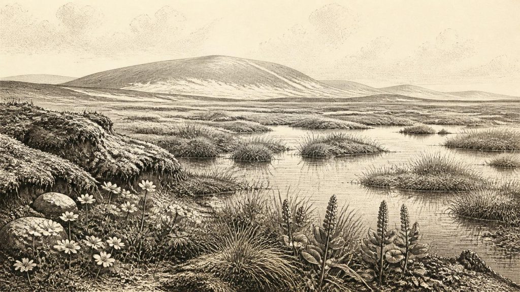
31,103 BCE is a label within a Late Pleistocene range, not a datable Irish event. Derryvree, County Fermanagh, preserves organic freshwater sediments between glacial tills, indicating an ice-free, cold, treeless wetland during part of Marine Isotope Stage 3. Mosses, sedges, mountain-avens and bogbean reveal tundra-like, seasonally thawed conditions, while later ice sealed the deposit. Ireland was not necessarily uniformly glaciated before the Last Glacial Maximum, but comprised changing regional environments. Castlepook Cave fauna records cold-adapted mammals and predators over time. A possibly cut-marked reindeer bone may indicate human contact, yet cannot establish settlement, population or activity in any single year.
Dateline
The label 31,103 BCE is a modern chronological convenience, not a date that can be matched to an event in Ireland. It lies about 33,052 years before AD 1950, the conventional reference point used in radiocarbon chronology, but no Irish community counted years in this way, left writing, or created an archaeological sequence precise enough to identify a particular season, person or occurrence. The responsible history of this notional year is therefore a history of dated ranges, sediments and probabilities.
Ireland was in the Late Pleistocene, within Marine Isotope Stage 3, during the long and unstable cold interval preceding the Last Glacial Maximum. Conditions altered sharply over centuries and millennia, and they varied by region. The best evidence relevant to this point in time comes from a buried freshwater deposit at Derryvree, near Maguiresbridge in County Fermanagh, together with cave faunas in southern Ireland and broader reconstructions of the British-Irish Ice Sheet. They illuminate a cold landscape with open vegetation and wet ground, but they cannot furnish a calendar-year snapshot of the island.
A Date Within a Range
The key Derryvree evidence was exposed during roadworks in 1969, when a cutting through a drumlin revealed organic silts and fine sands trapped between two separate sheets of glacial till. This order matters. An earlier glacier had laid down till; at some later time the locality supported standing or slow-moving freshwater and wetland vegetation; then renewed ice overrode and sealed the deposit beneath a further till sheet. It is one of Ireland’s rare surviving archives for an ice-free interval during the last glacial cycle.
The organic material produced the conventional radiocarbon determination Birm-166: 30,500 radiocarbon years before present, with a sizeable uncertainty of +1,170 and −1,030 years. Radiocarbon years are not identical to calendar years. Later calibration places the deposit broadly between about 36,900 and 31,700 calibrated years before present. That wide span overlaps the modern numerical position of 31,103 BCE, but does not prove that every fossil in the layer grew, died or was buried in that named year. Nor should the site be treated as a weather report for all Ireland. Its strength is more precise and more valuable: it establishes that north-central Ireland contained an ice-free, cold freshwater environment during part of this interval.
Wet Ground Between Glaciations
Derryvree’s plant and animal remains indicate an open, treeless tundra or muskeg landscape under periglacial conditions. Mosses, sedges, insects and plant macrofossils accumulated around shallow water, while herbs and low-growing plants occupied the surrounding ground. Mountain-avens, a plant now associated in Ireland with Arctic-alpine settings, occurred in the deposit. So did bogbean, whose fossil seed shows that freshwater pools or marsh margins sustained aquatic vegetation even in a severe cold-stage climate.
This was not a land of uninterrupted snow or featureless ice. Water could collect in hollows; fine sediment settled in quiet pools; plant communities took hold where moisture, seasonally thawed ground and available light allowed. Yet this was still a harsh world. The vegetation points to little or no woodland, short growing seasons and conditions shaped by frost. The term ‘muskeg’ conveys waterlogged, peaty ground, but it should not suggest a modern peat bog reproduced unchanged in deep time. The Derryvree assemblage records a particular cold freshwater ecosystem, not a complete map of the island.
The stratigraphy also records environmental change on a dramatic scale. The lower and upper tills demonstrate glacier activity before and after formation of the organic bed. At Derryvree, therefore, the history is neither a simple advance of ice nor a smooth thaw. It is a sequence of glaciation, exposed ground with water and vegetation, and renewed glaciation. Much of the evidence for this period has survived only because it was rapidly buried. Elsewhere, later ice erosion, meltwater, coastal change and thousands of years of soil formation have removed or reworked comparable traces.
Before the Maximum Ice
The date falls before the fullest documented expansion of the last British-Irish Ice Sheet. Reconstructions differ in detail, but they broadly place the major maximum extent of that ice sheet after this interval, around 27,000 to 21,000 years before present; marine evidence west and north-west of Ireland indicates shelf-edge ice later in the last glacial cycle. At 31,103 BCE, Ireland was already part of a cold North Atlantic world in which glaciers and ice sheets were growing and reorganising, but it should not automatically be pictured as uniformly buried beneath the later maximum ice cover.
Ice-sheet history was regional and dynamic. Uplands, coastal shelves, lowlands and drainage basins did not necessarily share the same conditions at the same time. The Derryvree sediments demonstrate ice-free ground in Fermanagh during their dated interval; they do not establish that all of Munster, Connacht, Leinster or Ulster was simultaneously open. Conversely, a local wetland does not imply a mild climate. The lesson is one of mosaic landscapes: frozen or seasonally frozen ground, pools and marshes, areas influenced by nearby ice, and habitats that could briefly support specialised plants and animals.
Sea level was much lower than today because vast volumes of water were stored in northern ice sheets. Ireland, Britain and the continental shelf formed a changing geographical system rather than the familiar modern island setting. Whether routes were continuously usable depended on sea level, ice margins, rivers, terrain and climate. It is reasonable to infer that animals could move into and out of Irish landscapes during favourable phases; it is not responsible to draw a neat land bridge, assign a route to a particular herd, or suppose permanent human settlement from geography alone.
Animals in the Irish Record
The richest evidence for Late Pleistocene animals in Ireland comes from limestone caves, especially Castlepook Cave near Doneraile in County Cork. Museum collections and more recent investigation show that the cave system contains remains attributable across a long span of time, including woolly mammoth, giant deer, reindeer, brown bear, wolf, Arctic fox, hare, lemmings and spotted hyaena. Such animals did not necessarily occupy the cave, or even southern Ireland, together at one moment. Cave deposits commonly combine material brought in by carnivores, animals dying naturally, water movement, roof collapse and earlier excavation.
Nevertheless, the fauna demonstrates that Irish environments in parts of Marine Isotope Stage 3 could support a far more varied large-mammal community than exists on the island today. Reindeer were suited to open, cold-country habitats; lemmings and Arctic fox imply similarly severe conditions. Hyaenas, wolves and bears remind us that the landscape was ecologically active, with scavenging, predation and competition as well as grazing. Mammoth and giant deer remains belong to this wider Pleistocene story, but their presence in a cave collection is evidence of animal occurrence over time, not proof of a single ‘mammoth landscape’ in 31,103 BCE.
This distinction is essential when reconstructing everyday life. We can reasonably describe wetland plants, cold-adapted animals and the processes that concentrated bones in caves. We cannot identify a camp, household, hunting party, shelter, clothing tradition or seasonal round in Ireland for this exact date. No securely excavated dwelling, hearth, stone-tool assemblage or burial from the island can presently be assigned to this point with the required confidence.
The Human Question at Castlepook
A reindeer femur from Castlepook has made this period especially significant. The bone, recovered during early twentieth-century cave work, has a deep mark interpreted by researchers as a possible fresh-bone chop or cut made with a sharp stone implement during carcass processing. A radiocarbon result on the specimen has been publicised as evidence for human activity in Ireland roughly 33,000 years ago. If that interpretation is confirmed through continued microscopic study, secure dating and discovery of corroborating material in undisturbed deposits, it would extend the potential Irish human record far earlier than the better-known Late Upper Palaeolithic evidence.
But the wording must remain cautious. A radiocarbon age dates the death of the animal, not automatically the instant when a surface mark was made. A mark interpreted as human-made must also be distinguished from damage caused by carnivore teeth, sediment movement, excavation tools, weathering or other taphonomic processes. And one modified bone would demonstrate an episode of human contact with a carcass, not a settlement, population size or an enduring occupation. Castlepook is a promising and important site precisely because it preserves questions that can be tested, rather than a licence to fill the evidential gaps with imagined Ice Age communities.
No Polities, but a Changing World
There is no evidence for political affairs, diplomacy, named groups, organised warfare, religion, formal learning, trade networks or artistic traditions in Ireland at this date. These are not missing chapters awaiting a written source; they are categories that the surviving evidence cannot responsibly sustain. It would be misleading to project later tribal identities, Gaelic language, farming society, monuments or Irish kingdoms backwards over more than thirty millennia.
If people did visit during a favourable interval, their social world would have been that of mobile Upper Palaeolithic hunter-gatherers known elsewhere in Europe, but this is an external comparison rather than direct Irish evidence. It can suggest possibilities—co-operation in hunting, skilled carcass processing, knowledge of seasonal animal movement and the use of stone tools—without converting them into facts about a group at Derryvree or Castlepook. No exchange of goods between communities can yet be documented from Ireland at this depth of time.
The principal Irish development relevant to 31,103 BCE was environmental rather than political: the persistence, for part of a dated range, of habitable cold-stage ground between glacial episodes. Derryvree preserves its quiet consequence in silt, seeds and mosses. Castlepook preserves a complementary record of animals, carnivores and a debated possible human intervention. Together they replace the old image of an empty, uniformly ice-covered island with a more rigorous one: a changing Pleistocene terrain whose rare records reveal ecological opportunity, but whose chronology does not permit the certainty of a single year.
Primary Sources
- A Middle Midlandian Freshwater Series at Derryvree, Maguiresbridge, County Fermanagh, Northern Ireland
- Trimlines, Blockfields and the Vertical Extent of the Last Ice Sheet in Southern Ireland
- A Reconsideration of the Radiocarbon Dating of the Marine Isotope Stage 3 Fauna from Southern Ireland
- The Irish Quaternary Fauna Project
- Growth and Retreat of the Last British–Irish Ice Sheet, 31,000 to 15,000 Years Ago: the BRITICE-CHRONO Reconstruction
- Extent and Timing of the Last Glacial Maximum (LGM) in Britain and Ireland: a Review
- Pattern and Timing of Retreat of the Last British-Irish Ice Sheet
- Maximum Extent and Dynamic Behaviour of the Last British–Irish Ice Sheet West of Ireland
- Early Deglaciation of the British-Irish Ice Sheet on the Atlantic Shelf Northwest of Ireland Driven by Glacioisostatic Depression and High Relative Sea Level
- Oscillating Retreat of the Last British-Irish Ice Sheet on the Continental Shelf Offshore Galway Bay, Western Ireland
- Dimensions and Chronology of the Last Ice Sheet in Western Ireland
- Episodic Speleothem Deposition Tracks the Terrestrial Impact of Millennial-Scale Last Glacial Climate Variability in SW Ireland
- New Insights on the Fauna of Ireland's Younger Dryas and Early Holocene from Alice & Gwendoline Cave
- Castlepook Cave, County Geological Site Report
- 2022:564 – Castlepook Cave, Castlepook South, Cork
- Heritage Artefacts of County Cork
- Guide to the National Museum of Ireland
- Irish Quaternary Association Field Guide 16
- Figure 6.—The Subdivision of the Quaternary Period in Ireland
- Menyanthes trifoliata: Fermanagh Species Account
- Dryas octopetala: Fermanagh Species Account
- The Colonization of Ireland: A Human Ecology Perspective
- The IntCal20 Northern Hemisphere Radiocarbon Age Calibration Curve (0–55 cal kBP)