

Derryvree’s Intertill Wetland30939 BCE
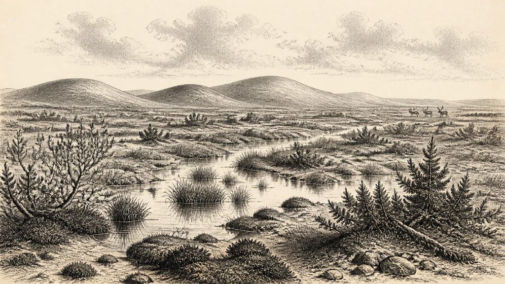
Thirty thousand nine hundred and thirty-nine BCE is not a recoverable Irish historical year, but falls within a broad Late Pleistocene calibrated range represented at Derryvree, County Fermanagh. There, freshwater organic sediments between glacial tills record an ice-free, treeless periglacial wetland of pools, sedges, mosses, herbs and cold-adapted insects. The site indicates local environmental change, not island-wide conditions. Ireland approached greater glaciation amid shifting ice, sea levels and possible connections with Britain. Castlepook Cave fauna document Pleistocene mammals; a possibly tool-marked reindeer bone suggests, but does not establish, human presence. No evidence supports permanent settlement, society or agriculture at all.
Dateline
The label 30,939 BCE cannot describe a recoverable year in Irish history. No calendar, written record, settlement sequence or securely dated event enables archaeologists to isolate a particular season, person or occurrence at this depth of time. It is a modern numerical label placed within the Late Pleistocene, broadly Marine Isotope Stage 3 (MIS 3), when climate and ice margins changed repeatedly. The responsible account is therefore one of deposits, fossils and calibrated ranges, not an annual chronicle.
A Date Within a Range
The most useful Irish evidence comes from Derryvree, near Maguiresbridge in County Fermanagh. Roadworks exposed a drumlin cut by a sequence of deposits: a lower glacial till, then fine sands and organic freshwater sediments, and finally an upper till. Till is unsorted material laid down by glacier ice. The order is consequently secure even where absolute dating is broad: ice had occupied the site; an ice-free interval allowed water, plants and animals to leave traces; later ice sealed that evidence beneath fresh debris.
Organic material from the intervening Derryvree deposits produced the conventional radiocarbon determination Birm-166, 30,500 +1,170/−1,030 radiocarbon years before present. “Present” in radiocarbon convention is AD 1950, not the present day. Radiocarbon ages of this antiquity are not calendar years and must be calibrated against changing atmospheric carbon levels. Scholarship using modern calibration places the deposit broadly at about 36,900–31,700 calibrated years BP, or roughly 34,950–29,750 BCE. The requested date falls inside that wide interval, but it cannot be assigned to a particular layer, pool, animal or human lifetime. The range is evidence; a precise year is not.
Derryvree is important because it demonstrates that at least one part of Fermanagh experienced a cold, non-glacial interval during the long build-up towards the Last Glacial Maximum. It does not prove that all Ireland was ice-free at once. Nor should it be treated as a weather station for the whole island. Nevertheless, its unusually rich plant, insect and sedimentary record gives a rare, local view of an Ireland very different from the familiar wooded and farmed landscape of later millennia.
Cold Water, Open Ground
The fossil assemblage points to a treeless, periglacial wetland mosaic. Pollen, seeds, plant fragments and mosses include grasses and sedges, juniper, herbs and species associated with shallow freshwater or saturated ground. Bogbean, water-milfoil, mountain-avens, dwarf willow and lesser clubmoss have all been identified or reported from the Derryvree record. Together with insects of cold northern character, they support an interpretation of pools, wet margins, mossy ground and sparse open vegetation rather than mature temperate woodland.
“Tundra” is a useful shorthand, provided it is not made too uniform. The evidence suggests patches of water, sedge-rich marsh, low-growing plants and exposed mineral ground, responding to local drainage, relief and season. A drumlin landscape could create sheltered hollows as well as wind-swept rises. Summer growth may have been intense but brief; winters were severe, and frost action shaped the ground. The organic beds preserve a living wetland because later ice covered and protected them. Their survival is exceptional, not proof that comparable deposits once remained everywhere.
Regional records reinforce the larger conclusion that the late Ice Age was not one uninterrupted freeze. Organic deposits at Hollymount near Maguiresbridge and Greenagho near Belcoo, as well as other sequences in Northern Ireland, show that cold, ice-free or less heavily glaciated phases occurred between episodes of glacial advance. Yet the chronology of individual Irish cold stages remains debated. Correlations made from old regional names such as the Fermanagh, Derryvree and Maguiresbridge substages remain useful descriptive tools, but modern ice-sheet research warns against treating them as a single, island-wide timetable.
An Island Approaching Glaciation
At this point in the wider last glacial cycle, Ireland lay in an unstable north-west European zone. The Last Glacial Maximum itself came later, conventionally around 26,500–19,000 years ago globally, although advances and retreat differed markedly from one sector of the British–Irish Ice Sheet to another. Large modern dating programmes show ice expansion across Ireland and its continental shelves occurring asynchronously between about 30,000 and 22,000 years ago, with maximum ice volume around 23,000 years ago.
For the period encompassing 30,939 BCE, that means neither a simple picture of an entirely ice-covered Ireland nor one of a mild, continuously habitable island is warranted. Derryvree shows ice-free freshwater conditions in Fermanagh during the broad calibrated interval. Elsewhere, glaciers, permafrost-like ground conditions, meltwater and changing sea levels altered routes, habitats and preservation. Later ice eroded many older landscapes and buried others under till. This geological violence is one reason why the archaeological record is so fragmentary: absence of a camp is not automatically proof that no person ever entered Ireland, but it is also not evidence that people lived there.
Sea level was considerably lower than today because water was held in northern ice sheets. Ireland was therefore not necessarily separated from Britain by the familiar modern sea channels throughout every part of MIS 3. But coastlines, rivers and potential land connections shifted over long intervals, and much of any former lowland terrain now lies beneath the Irish Sea or has been reworked by later ice and water. It is responsible to say that movements of animals and, potentially, people were geographically more possible than under modern conditions; it is not responsible to map a precise route for a journey in this notional year.
Cave Fauna and a Cautious Human Question
Castlepook Cave, also called Mammoth Cave, near Doneraile in County Cork, provides the principal Irish faunal counterpoint to Derryvree’s wetland record. Excavations begun in the early twentieth century recovered a remarkable collection that includes reindeer, woolly mammoth, giant deer, brown bear, wolf, Arctic fox, lemmings and spotted hyena. The National Museum of Ireland holds, among other specimens, an incomplete spotted-hyena skull from the cave. Such animals show that Ireland was reached, at different times during the Late Pleistocene, by mammal communities now unimaginable in the island’s fauna.
These cave deposits must be handled carefully. A cave bone collection is not a snapshot of a single landscape or year. Carnivores may have dragged prey into dens; animals died at different times; water and sediment moved material; and the early excavations pre-dated present-day standards of contextual recording. Radiocarbon work by the Irish Quaternary Fauna Project showed that Irish mammals colonised during a long span, at least between about 45,000 and 20,000 years ago. Individual species and bones from Castlepook cannot therefore all be assumed contemporary with Derryvree.
One reindeer femur from Castlepook has an especially consequential, but limited, relevance. Zooarchaeologist Ruth Carden has interpreted a deep linear mark on it as damage made by a sharp stone tool while fresh bone was being processed. County Cork heritage material presents the object as dating to about 31,000 BCE. If that interpretation and association are sustained, it would indicate Upper Palaeolithic people handled a reindeer in Ireland during a broad period near this date.
That is not evidence for a settled Irish population. No securely associated hearth, stone-tool assemblage, dwelling, burial, art object or repeatedly occupied surface of comparable age has been recovered at Castlepook. Recent excavation has sought surviving Pleistocene deposits but reported no cultural artefacts. A single marked bone cannot determine whether people hunted the animal, scavenged it, took hide or sinew, stayed for hours or weeks, travelled in a party, or returned. The securely dated cut-marked brown-bear bone from Alice and Gwendoline Cave in County Clare is much later, around 12,800–12,600 calibrated years BP. It remains the firmer direct archaeological evidence for human activity in Ireland.
Society Beyond the Evidence
There were no states, kings, borders, treaties or recorded political affairs in Ireland at this time. Equally, the evidence does not permit the reconstruction of clans, languages, religious observance or named cultural traditions. There is no basis for claiming that any group held a permanent territory in Fermanagh or Cork, traded across a particular route, or practised a known ritual. Those are questions archaeology can sometimes approach through camps, tools, burials and repeated settlement traces; the Irish evidence for this period does not yet provide them.
If humans did visit, their everyday priorities would have resembled those of mobile Upper Palaeolithic groups elsewhere in north-west Europe: warmth, shelter, fresh water, animal food, hides, fuel and workable stone. Reindeer and other herbivores would have been potential resources, while wolves and spotted hyenas were formidable competitors and scavengers. But this is comparative interpretation, not a description of an excavated Irish camp. No evidence currently demonstrates agriculture, domesticated animals, metalworking, long-distance commerce or permanent villages on the island.
The strongest history for 30,939 BCE is thus environmental. Beneath a Fermanagh drumlin, freshwater sediments preserve a cold wetland alive with plants, insects and seasonal change. In Cork caves, bones testify to animal movements through an intermittently connected Ice Age world. Together they reveal an island of shifting habitats at the threshold of more extensive glaciation. They also define the limits of knowledge: Ireland can be placed within a broad calibrated interval, but no responsible account can turn that interval into a dated human drama.
Primary Sources
- A Middle Midlandian Freshwater Series at Derryvree, Maguiresbridge, County Fermanagh, Northern Ireland
- Early Midlandian–Middle Midlandian, Pleistocene, Northern Ireland
- Irish Quaternary Association Guide 16: The Quaternary of Northern Ireland
- The IntCal20 Northern Hemisphere Radiocarbon Age Calibration Curve (0–55 cal kBP)
- Growth and Retreat of the Last British–Irish Ice Sheet, 31,000 to 15,000 Years Ago: the BRITICE-CHRONO Reconstruction
- The Timing and Magnitude of the British–Irish Ice Sheet Between Marine Isotope Stages 5d and 2: Implications for Glacio-Isostatic Adjustment, High Relative Sea Levels and ‘Giant Erratic’ Emplacement
- Last Glacial Maximum Cirque Glaciation in Ireland and Implications for Reconstructions of the Irish Ice Sheet
- Dimensions and Chronology of the Last Ice Sheet in Western Ireland
- Late Pleistocene Chronostratigraphy and Ice Sheet Limits, Southern Ireland
- Oscillating Retreat of the Last British-Irish Ice Sheet on the Continental Shelf Offshore Galway Bay, Western Ireland
- The Deglaciation of the Western Sector of the Irish Ice Sheet from the Inner Continental Shelf to its Terrestrial Margin
- Timing and Pace of Ice-Sheet Withdrawal Across the Marine–Terrestrial Transition West of Ireland During the Last Glaciation
- The Irish Quaternary Fauna Project
- Spotted Hyena Skull
- Castlepook Cave, Co. Cork, 2022 Excavation Report
- Archaeological Heritage of County Cork
- Heritage Artefacts of County Cork
- First Evidence of a Late Upper Palaeolithic Human Presence in Ireland
- New Insights on the Fauna of Ireland’s Younger Dryas and Early Holocene from Alice & Gwendoline Cave
- Freshwater Organic Deposits and Stratified Sediments Between Early and Late Midlandian (Devensian) Till Sheets, at Aghnadarragh, County Antrim, Northern Ireland
- A Critical Review and Re-investigation of the Pleistocene Deposits Between Cranfield Point and Kilkeel, Northern Ireland: Implications for Regional Sea-Level Models and Glacial Reconstructions of the Northern Irish Sea Basin
- Irish Pleistocene Biostratigraphy
- Myriophyllum alterniflorum DC.
- Salix herbacea L.








