

Maguirebridge’s Frostwater Basin30961 BCE
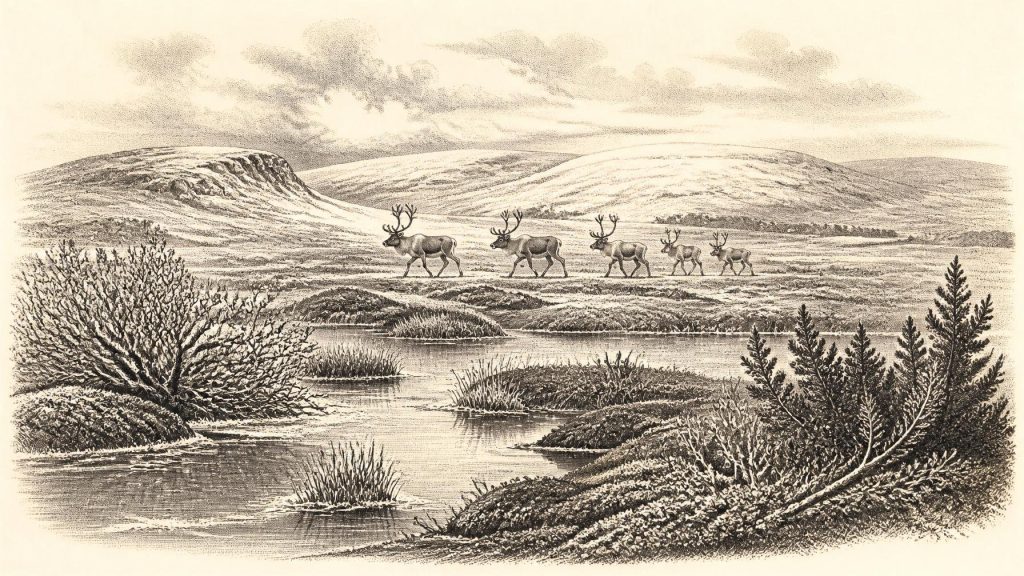
Around 30,961 BCE, Ireland lay within the climatically unstable Late Pleistocene. At Derryvree near Maguiresbridge, freshwater organic sediments between glacial tills show that Fermanagh experienced an ice-free interval during MIS 3. Pollen, plants and insects describe a cold, open, tundra-like wetland with pools, sedges, mosses and sparse shrubs. Castlepook Cave in Cork preserves diverse fauna, including reindeer, mammoth and predators, indicating varied habitats within a wider north-west European ecosystem. A marked reindeer bone may indicate human butchery, but cannot demonstrate permanent settlement. Growing ice later transformed and obscured this precarious landscape, leaving no evidence of communities, politics or ritual here.
Dateline
30,961 BCE is not a recoverable Irish year. It is a modern calendar label for a point about 32,911 years before AD 1950, within the Late Pleistocene and Marine Isotope Stage 3 (MIS 3). No Irish inscription, settlement layer or dated event permits an annual narrative at this depth of time. The responsible approach is therefore to ask what deposits, fossils and glacial evidence can say about a broad interval encompassing that notional year. Radiocarbon measurements of this antiquity require calibration and normally yield ranges rather than a precise calendar point; IntCal20 extends the Northern Hemisphere calibration curve to 55,000 calibrated years before present, but does not turn a single Irish find into a historical date.
An Intertill Window
The key Irish evidence comes from Derryvree near Maguiresbridge in County Fermanagh. During roadworks, geologists exposed fine freshwater sediments and organic material sandwiched between two layers of glacial till. This sequence is exceptionally important because its order records change rather than merely a chance fossil discovery: an earlier ice advance deposited the lower till; ice-free freshwater conditions followed; then a later advance sealed the wetland below fresh glacial debris. Organic material gave a radiocarbon age of 30,500 +1,170/−1,030 radiocarbon years BP. When calibrated, it belongs to a wide late-MIS-3 interval, broadly extending through the period around 30,961 BCE. It cannot establish what happened in one year, one season or even one human lifetime, but it securely demonstrates that this part of Fermanagh was not continuously under ice throughout the period represented.
Derryvree was not an early version of Ireland’s familiar green, wooded countryside. Its pollen, plant macrofossils and insect remains indicate cold, open ground with freshwater pools and waterlogged vegetation: a periglacial wetland or muskeg-like mosaic. Grasses and sedges were prominent, alongside juniper and herbs. Mosses were abundant. Fossil evidence includes bogbean, water-milfoil, mountain-avens, dwarf willow and lesser clubmoss—plants consistent with shallow water, saturated margins, sparse cover and exposed terrain. Insects added a complementary signal: not a forest community, but cold northern conditions with organic-rich pools and mossy ground. This is direct environmental evidence from one locality. It supports a landscape of tundra-like wetland around Maguiresbridge, not an assertion that every Irish valley, coast and upland looked identical.
Cold Country, Moving Ice
The wider island was undergoing profound environmental instability. MIS 3 was neither a uniformly mild interval nor the final maximum of the last glaciation. Ice masses, sea levels, vegetation belts and animal ranges altered repeatedly across north-west Europe. The British–Irish Ice Sheet was beginning a major phase of growth in the broad period from about 31,000 years ago, though its margins did not advance everywhere at the same speed or reach a single simultaneous maximum. Reconstructions place its greatest overall extent later, principally around 27,000–23,000 years ago. Consequently, Ireland around the date represented here should be understood as a changing borderland of ice, meltwater, exposed ground and local refuges—not as a wholly ice-covered island, but not as a stable ice-free homeland either.
That distinction matters for regional change. Derryvree’s buried freshwater deposits show that northern inland habitats existed during a cold phase before renewed glaciation. Offshore and coastal records, meanwhile, indicate that the Irish ice mass had a longer and more complicated pre-Last Glacial Maximum history than older simple models allowed. Lower global sea level exposed more continental shelf than today, reshaping coastlines and possible routes between Ireland, Britain and mainland Europe. Yet exposed shelf does not prove a convenient, continuous land bridge at a particular moment, nor does it prove that people or every animal species used it. Routes could have been interrupted by seawater, ice, rivers, marshes and changing ice margins.
The Cave Fauna of Cork
Southern Ireland supplies another vital, if different, archive. Castlepook Cave near Doneraile, County Cork—also called Mammoth Cave—has produced a remarkable assemblage of Late Pleistocene animal remains. Improved radiocarbon pretreatment has shown that some bones formerly thought much younger are in fact substantially older, placing part of the fauna in MIS 3. The broader pre-Last Glacial Maximum Irish record includes reindeer, woolly mammoth, giant deer, horse, brown bear, wolf, Arctic fox, mountain hare, lemmings and spotted hyaena. These animals do not constitute a single herd observed on a single day. Cave deposits can be accumulated by carnivores, water, natural deaths, sediment movement and nineteenth- or early twentieth-century excavation. Their significance lies in showing that Ireland, at different points in this broad cold interval, formed part of a north-west European ecological world capable of supporting large grazing animals, small cold-adapted mammals and formidable predators.
For everyday life in the animal world, this meant mobility and risk. Reindeer could exploit open country and seasonal vegetation; hyaenas and wolves were predators and scavengers; mammoths and giant deer required substantial feeding grounds. Wet hollows such as Derryvree may have concentrated water, plant foods and animal traffic, while exposed ridges and gravelly surfaces offered very different conditions. But the evidence cannot furnish population figures, migration calendars or a complete food web. Nor should the popular image of a single “mammoth-steppe” be imposed mechanically on every Irish locality. Derryvree records wet tundra-like ground; Castlepook records faunal remains in a limestone cave system. Together they reveal varied habitats, not a map of an entire island frozen in one ecological moment.
A Possible Human Trace
The possibility of people in Ireland around this horizon rests principally on a reindeer femur from Castlepook. County Cork heritage material reports that the bone, recovered from the cave’s historic collections, was radiocarbon dated to roughly 33,000 years ago and bears deep modifications interpreted as stone-tool marks made while fresh bone was being processed. If that interpretation is sustained, it is highly important: it would indicate a brief Upper Palaeolithic human encounter with a reindeer carcass far earlier than Ireland’s better-established terminal-Pleistocene evidence. Yet its limits are equally important. A date on the animal establishes when it died, not the duration of a human visit; a marked bone is not a house, hearth, stone-tool assemblage, burial ground or village. The cave’s complex depositional history prevents the reconstruction of a campsite or a named community.
Accordingly, political affairs, diplomacy and organised conflict are unknown for Ireland at this time. There is no evidence for rulers, territorial polities, alliances or warfare. There is likewise no secure Irish evidence for religion, ritual, cave art, formal burial, long-distance trade or a distinctive learned tradition around 30,961 BCE. It would be reasonable only in the most general sense to note that mobile Upper Palaeolithic groups elsewhere in Europe possessed sophisticated stone technologies and cultural traditions; it would not be reasonable to assign those particular practices to Ireland without an Irish assemblage. The most defensible social interpretation is modest: if the Castlepook mark is human-made, one or more people may have reached or moved through this changing landscape and processed animal tissue. Whether they stayed, returned, travelled by land or water, or left descendants is not known.
History Before History
This was therefore not a year of kings, monuments or recorded battles, but a threshold in Ireland’s deep past. At Maguiresbridge, freshwater silts, mosses, seeds and insects preserve evidence of an open, cold wetland between episodes of glaciation. At Castlepook, bones preserve the presence of a changing Ice Age fauna and a tantalising, still limited possible sign of human butchery. Subsequent ice advances could erode landscapes, redistribute sediments and destroy or conceal evidence, helping to explain why the record is so sparse. Around 30,961 BCE, Ireland can responsibly be pictured as environmentally alive but climatically precarious: a land of frostwater pools, sedges, low shrubs, wandering animals and encroaching ice, with human presence possible but far from demonstrated as permanent settlement.
Primary Sources
- A Middle Midlandian Freshwater Series at Derryvree, Maguiresbridge, County Fermanagh, Northern Ireland
- The IntCal20 Northern Hemisphere Radiocarbon Age Calibration Curve (0–55 cal kBP)
- IntCal Publications
- The Irish Quaternary Fauna Project
- A Reconsideration of the Radiocarbon Dating of the Marine Isotope Stage 3 Fauna from Southern Ireland
- Irish Quaternary Vertebrates
- Advances in Irish Quaternary Studies
- Radiocarbon Constraints on the History of the Western Irish Ice Sheet Prior to the Last Glacial Maximum
- Late Pleistocene Chronostratigraphy and Ice Sheet Limits, Southern Ireland
- Growth and Retreat of the Last British–Irish Ice Sheet, 31,000 to 15,000 Years Ago: the BRITICE-CHRONO Reconstruction
- Growth and Retreat of the Last British–Irish Ice Sheet, 31,000 to 15,000 Years Ago: the BRITICE-CHRONO Reconstruction
- Ireland: Submerged Prehistoric Sites and Landscapes
- British–Irish Ice Sheet and Polar Front History of the Goban Spur, Offshore Southwest Ireland Over the Last 250,000 Years
- Character of Advance and Retreat of the Southwest Sector of the British-Irish Ice Sheet During the Last Glaciation
- Stratigraphic and Palaeo-geomorphological Evidence for the Glacial-deglacial History of the Last British-Irish Ice Sheet in the North-western Irish Sea
- First Evidence of a Late Upper Palaeolithic Human Presence in Ireland
- New Insights on the Fauna of Ireland’s Younger Dryas and Early Holocene from Alice & Gwendoline Cave
- Prehistoric Details
- Archaeological Heritage of County Cork
- Heritage Artefacts of County Cork
- Castlepook Cave, Co. Cork, Excavation Report 2022
- Landscapes and Environments of the Last Glacial-interglacial Transition: a Time of Amazingly Rapid Change in Ireland
- Trimlines, Blockfields and the Vertical Extent of the Last Ice Sheet in Southern Ireland
- Freshwater Organic Deposits and Stratified Sediments Between Early and Late Midlandian (Devensian) Till Sheets, at Aghnadarragh, County Antrim, Northern Ireland