

BIRM-166’s Fermanagh Drumlin30835 BCE
At approximately 30,835 BCE, Ireland cannot be described through annual history, but Derryvree, County Fermanagh, provides evidence for a broader MIS 3 interval. Organic freshwater sediments, lying between two tills beneath a drumlin, produced radiocarbon date BIRM-166, calibrated broadly to 34,950–29,750 BCE. They record an ice-free, cold, treeless wetland supporting mosses, sedges, grasses and arctic-alpine plants. Southern cave deposits show cold-stage mammals, including reindeer and mammoth, although their mixed contexts prevent precise reconstruction. A possibly tool-marked reindeer bone suggests human activity, not settlement. Expanding ice later transformed and erased landscapes; no evidence supports societies, trade or political events at all.
Dateline
Modern calendar-year precision is not available for Ireland in 30,835 BCE. No written chronology, named community, settlement sequence or archaeological layer can identify events in that particular year. The label is a modern one: measured from the conventional radiocarbon reference point of AD 1950, it lies about 32,785 years before present. What can responsibly be discussed is a broad Late Pleistocene interval within Marine Isotope Stage 3 (MIS 3), a climatically unstable part of the last Ice Age, using evidence dated in ranges rather than a historical diary.
The closest and most informative Irish evidence is a buried freshwater deposit at Derryvree, near Maguiresbridge in County Fermanagh. It does not document a political event or a human settlement. It does, however, preserve an exceptional environmental record from an interval before the Last Glacial Maximum. Together with cave-fauna evidence from southern Ireland, it reveals a changing island of treeless wetlands, cold-adapted plants, large mammals and advancing ice. It also sets strict limits on what can be claimed about people.
A Date Within a Range
During roadworks in 1969, an exposure cut through a drumlin at Derryvree. Beneath the rounded glacial landform lay two thick sheets of till, the unsorted sediment deposited by moving glacier ice. Between them were freshwater silts, fine sands and organic muds. The sequence is crucial: an earlier glacial episode had laid down till; a period followed in which standing or slow-moving fresh water, vegetation and organic matter accumulated; later ice buried the deposit beneath another till sheet.
Organic material from the Derryvree sediments produced the radiocarbon determination BIRM-166, conventionally dated to 30,500 radiocarbon years BP, with an uncertainty of roughly a millennium. Radiocarbon years are not calendar years. Atmospheric carbon-14 has varied through time, so dates must be calibrated against independently dated records. Published discussion of BIRM-166 places it broadly within about 36,900–31,700 calibrated years BP, or approximately 34,950–29,750 BCE. The requested date falls inside that broad interval, but it cannot be assigned to a single sediment layer, season or lifetime.
This uncertainty is not a defect to be concealed; it is the central historical fact. Derryvree can illuminate conditions in northern Ireland around this part of MIS 3, but it cannot prove the weather, shoreline, animal population or human presence on the whole island in 30,835 BCE. Nor should an old radiocarbon determination be treated as fixed forever: calibration curves, laboratory methods and Bayesian models are revised as chronology improves.
The Derryvree Wetland
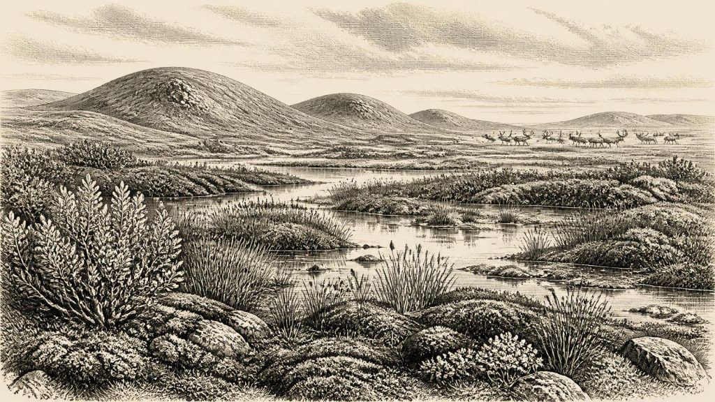
The plant and animal remains in the organic layers depict a cold, open and largely treeless landscape. Mosses, sedges, grasses and arctic-alpine herbs indicate a tundra or muskeg-like wetland rather than woodland. Finds such as bogbean, mountain-avens, dwarf willow, lesser clubmoss and aquatic plants show that this was not sterile ground. Around shallow pools and wet sedge beds, plants persisted through short growing seasons in a periglacial climate: one shaped by severe cold, seasonal thaw and frost action, but not continuously sealed beneath glacier ice.
Such evidence gives the most secure picture of ordinary ‘life’ in Ireland at this depth in time—not human domestic life, but the workings of an ecosystem. Water gathered in a depression among glacial deposits. Fine sediment settled. Mosses and wetland plants grew, died and accumulated. Invertebrates and other small organisms occupied particular niches. The local scene was capable of supporting a food web, yet it was exposed to pronounced seasonality and long-term climatic swings. The vegetation was probably low and patchy, with broad horizons, strong winds and little shelter compared with later forested Ireland.
Derryvree is therefore evidence for an ice-free episode in this part of Fermanagh, not proof that every Irish region was similarly open or habitable. Ireland’s Pleistocene deposits are fragmentary because subsequent glaciers eroded, redeposited or buried older surfaces. A road cutting through a drumlin is a rare accident of preservation. Its importance lies precisely in showing that the landscape had not followed one uninterrupted path from ice to ice.
Before the Great Expansion
At this point the British–Irish Ice Sheet had not yet reached its later maximum extent. Modern reconstructions place the principal build-up after roughly 35,000–32,000 years ago, with maximum ice-sheet extent broadly in the period around 27,000–21,000 years ago, although timings varied across individual sectors. At 30,835 BCE, Ireland was thus in a period of major environmental change preceding the fullest Last Glacial Maximum, not in a simple island-wide state of permanent ice cover.
The upper till at Derryvree records that ice eventually returned to the locality. This makes the wetland a brief chapter within a much longer glacial history. As ice expanded, it would have transformed drainage, displaced or destroyed habitats, and scoured many older deposits from the land surface. Drumlins, eskers, lake basins and the general shape of many modern Irish lowlands owe much to later glacial processes, but they should not be projected unchanged into this earlier interval.
Lower global sea levels also altered the continental shelf and the surrounding coasts. Yet a lower sea is not, by itself, evidence of an easy dry route to Ireland. Ice margins, river systems, exposed shelf terrain and sea channels changed repeatedly. There is no securely reconstructed journey, crossing or migration corridor that can be assigned to this exact date. The appropriate conclusion is one of changing regional geography, not a confident map of a land bridge.
Caves, Mammals and a Human Question
Southern Irish caves offer a second, more dramatic but more difficult body of evidence. Castlepook Cave, near Doneraile in north County Cork, has produced remains of reindeer, woolly mammoth, giant deer, brown bear, wolf, Arctic fox, mountain hare, lemmings and spotted hyaena. Improved radiocarbon work has shown that some cave fauna belongs to MIS 3, well before the Last Glacial Maximum. This confirms that Ireland supported, or was reached by, a changing suite of cold-stage mammals over a long span of time.
It does not mean that every animal in the Castlepook collections stood together in one landscape in 30,835 BCE. Cave deposits commonly mix bones accumulated in different centuries or millennia through carnivore activity, water movement, sediment disturbance and earlier excavation. A cave can be a superb archive while remaining a poor snapshot. Individual bone dates and their exact stratigraphic contexts matter more than an impressive species list.
One Castlepook object is especially relevant to the possibility of people in Ireland before the ice-sheet maximum: a reindeer femur bearing a deep mark interpreted by palaeozoologist Ruth Carden as having been made by a sharp stone tool during carcass processing. County Cork heritage material presents it as broadly around 31,000 BCE. If that interpretation is sustained, it would be a striking indication that a person handled a reindeer in Ireland during this general period.
Even then, the evidence would demonstrate an action, not a settled society. The bone was part of an old cave collection rather than a securely excavated camp containing associated stone tools, hearths, shelters, food debris and repeated occupation surfaces. No known human remains, domestic structures, art assemblage or burial can be placed in Ireland at or near 30,835 BCE. The marked femur is a serious research question, not licence to invent a permanent population, a named people or a Palaeolithic village at Doneraile.
Society Beyond the Evidence
Political affairs, warfare and diplomacy cannot be recovered for Ireland at this date. There are no known leaders, territorial systems, alliances, fortified places or monuments. Likewise, there is no evidence from which to infer a language, ethnic identity, kinship system, religious rite or artistic tradition. Upper Palaeolithic societies elsewhere in Europe demonstrate that people of this era could possess sophisticated skills and symbolic cultures, but Irish evidence does not allow those characteristics to be transferred automatically across the sea.
Economy and trade are equally beyond direct observation. If humans entered Ireland intermittently, they may have travelled as highly mobile hunter-gatherers and made use of animal resources, but that remains an inference from wider European archaeology, not an established Irish record. There is no securely dated Irish evidence here for exchange networks, permanent settlement, farming, herding, metalworking or maritime commerce. Agriculture, pottery, monuments and the dense archaeological record usually associated with prehistoric Ireland all belong to vastly later periods.
The most consequential ‘regional change’ was ecological. Wetlands at Derryvree, cave animals in Munster and the looming expansion of ice show an Ireland repeatedly opened, altered and in many places later erased by glaciation. That process helps explain why the island’s deep human past is so difficult to detect. Absence of evidence cannot conclusively prove that no person ever arrived, but neither can it be filled with an imagined population.
A Responsible Picture
Ireland around 30,835 BCE was an Atlantic-edge landscape within the last Ice Age: cold, treeless in the best-documented Fermanagh setting, locally wet enough to sustain freshwater plants and mosses, and inhabited at least during the broader period by cold-adapted fauna. It was also a landscape on the threshold of major glacial transformation. Derryvree’s organic silts are the clearest local witness because they record an ice-free interval between advances; Castlepook’s bones widen the view towards southern mammal life and the unresolved possibility of human activity.
This is not a year of kings, battles or foundations. It is a date that directs attention to a buried wetland, a drumlin, a cave archive and the discipline required by deep time: calibrated ranges before exact years, deposits before stories, and evidence clearly separated from interpretation.
Primary Sources
- A Middle Midlandian Freshwater Series at Derryvree, Maguiresbridge, County Fermanagh, Northern Ireland
- Exploring Controls of the Early and Stepped Deglaciation on the Western Margin of the British-Irish Ice Sheet
- Irish Pleistocene Biostratigraphy
- A Reconsideration of the Radiocarbon Dating of the Marine Isotope Stage 3 Fauna from Southern Ireland
- The Irish Quaternary Fauna Project
- Growth and Retreat of the Last British–Irish Ice Sheet, 31,000 to 15,000 Years Ago: The BRITICE-CHRONO Reconstruction
- Extent and Timing of the Last Glacial Maximum in Britain and Ireland: A Review
- The Timing and Magnitude of the British–Irish Ice Sheet Between Marine Isotope Stages 5d and 2
- Early Deglaciation of the British-Irish Ice Sheet on the Atlantic Shelf Northwest of Ireland Driven by Glacioisostatic Depression and High Relative Sea Level
- Maximum Extent and Dynamic Behaviour of the Last British–Irish Ice Sheet West of Ireland
- Trimlines, Blockfields and the Vertical Extent of the Last Ice Sheet in Southern Ireland
- Radiocarbon Constraints on the Age of the Maximum Advance of the British–Irish Ice Sheet in the Celtic Sea
- Episodic Speleothem Deposition Tracks the Terrestrial Impact of Millennial-Scale Last Glacial Climate Variability in SW Ireland
- The IntCal20 Northern Hemisphere Radiocarbon Age Calibration Curve (0–55 cal kBP)
- Ireland: Submerged Prehistoric Sites and Landscapes
- First Evidence of a Late Upper Palaeolithic Human Presence in Ireland
- New Insights on the Fauna of Ireland’s Younger Dryas and Early Holocene from Alice & Gwendoline Cave
- The Exploration of Castlepook Cave, Co. Cork
- Heritage Artefacts of County Cork
- Archaeological Heritage of County Cork
- The Mesolithic in Ireland: When Was It?
- Ireland Through Geological Time
- Aghnadarragh: Northern Ireland Environment Agency Earth Science Conservation Review
- Figure 6: The Subdivision of the Quaternary Period in Ireland