

Fermanagh’s Clubmoss Spore30636 BCE
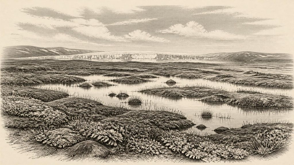
30,636 BCE is a modern label within the unstable Late Pleistocene, not a recordable Irish year. At Derryvree, County Fermanagh, sediments between two tills document a local ice-free interval, dated broadly to about 34,950–29,750 BCE. Freshwater silts, mosses, sedges, clubmoss, bogbean, mountain-avens and insects indicate cold, wet, open tundra-like ground with pools. Other Irish cave deposits show that Ice-Age mammals, including mammoth and reindeer, occurred during wider periods, but cannot be treated as contemporaneous local evidence. No secure proof establishes human occupation, settlement or culture. Later ice expansion reshaped Ireland, leaving Derryvree as an exceptional, fragmentary environmental archive for science.
Dateline
A Date Beyond Annual History
30,636 BCE is a modern chronological label, not a year that anyone in Ireland could have named, counted or recorded. In radiocarbon convention it falls roughly 32,585 years before AD 1950, but no archaeological evidence can isolate a particular Irish event, season or generation at that resolution. The responsible frame is therefore a much broader one: the Late Pleistocene, within Marine Isotope Stage 3 (MIS 3), a climatically unstable portion of the last Ice Age. The evidence consists chiefly of layers of sediment, fossil plants, insects and animal bones, interpreted through stratigraphy and scientific dating rather than through written records or settlements.
The closest important Irish evidence is a freshwater deposit at Derryvree, near Maguiresbridge in County Fermanagh. Its conventional radiocarbon determination, Birm-166, was 30,500 radiocarbon years before present, with a substantial uncertainty of +1,170 and −1,030 years. Radiocarbon years are not calendar years: the amount of atmospheric carbon-14 has varied, so laboratory results must be calibrated against independently dated records. At this antiquity calibration produces a broad probability range, not an anniversary. The Derryvree material is commonly placed within approximately 36,900–31,700 calibrated years BP, or about 34,950–29,750 BCE. The requested date sits within that wide interval, but cannot be attached to a single plant, animal, pool or human action.
Fresh Water Between Glaciers
Roadworks in 1969 cut through a drumlin at Derryvree, exposing a remarkable sequence. A lower sheet of till – the unsorted debris deposited by glacier ice – was overlain by fine sands, freshwater silts and organic material, themselves sealed beneath a later till. The order of those layers is the strongest conclusion. Ice had occupied the ground; then a local interval without overriding ice allowed water, sediment and living things to accumulate; later glacial activity buried the wetland. This is direct evidence for environmental change at one Fermanagh locality, not a map of all Ireland at one moment.
That distinction is essential. A surviving inter-till deposit does not prove that every coast, upland and valley was ice-free at the same time. Ireland’s land surface, now separated from Britain by sea, was then part of a wider north-west European region whose shorelines, drainage and possible routes were repeatedly transformed by falling sea level, changing ice margins and later erosion. Much of the older landscape was removed, disturbed or concealed by subsequent glaciation. Derryvree is valuable precisely because it is an unusually well-preserved local archive amid such loss.
Wet Ground and Open Vegetation
The fossils at Derryvree show that this was not simply a featureless field of snow. Freshwater mosses and sedges, together with a cold-climate insect fauna, indicate pools or sluggish water and saturated ground under a periglacial climate. Plant finds include lesser clubmoss, mountain-avens and bogbean; pollen attributed to alternate water-milfoil is further evidence for fresh water. Such species support a reconstruction of low, open tundra-like vegetation, with wet margins, patches of herbs and moss, and exposed mineral ground rather than closed woodland. The evidence demonstrates particular organisms and conditions near the deposit; the wider picture of a varied wetland-and-tundra mosaic is an interpretation drawn from their combination.
Seasonality would have mattered greatly. Long, cold winters, frost action, shallow summer thaw and waterlogging would have governed where plants could root and where animals could feed. A pool margin could be locally productive in a landscape otherwise constrained by cold and wind. Yet it would be misleading to turn that observation into a familiar pastoral scene. There is no evidence here for fields, crops, livestock, woodland clearance or permanent dwellings. This was a landscape shaped principally by climate, water and ice, not by documented human land management.
Animals in a Fragmentary Record
Other Irish sites broaden the ecological setting, although they must not be treated as if they were contemporary snapshots of Derryvree. Cave deposits at Castlepook near Doneraile, County Cork, have yielded remains attributed to cold-stage animals including mammoth, reindeer, giant deer, wolf, fox, arctic fox, spotted hyaena, hare and lemmings. Ireland’s Quaternary fauna project concluded that a wide range of mammals reached the island between at least about 45,000 and 20,000 years ago. This demonstrates that parts of Ice-Age Ireland could support substantial herbivores, predators and scavengers during broad intervals of the Late Pleistocene.
But cave bones have complicated histories. Animals may die naturally, be dragged in by carnivores, be moved by water or become mixed with material from other episodes. Many Irish cave collections were excavated before modern recording methods and contain disturbed deposits. More recent radiocarbon reassessment has refined the chronology of southern Irish MIS 3 fauna, but it has not transformed Castlepook into a securely dated camp-site. Mammoth or reindeer remains are strong evidence that these species occurred in Ireland during a broad period; they do not prove that every animal listed above occupied one valley, or even lived at exactly the same time.
People: An Evidential Silence
For 30,636 BCE, there is no securely documented Irish house, hearth, stone-tool assemblage, burial, occupation floor, artwork or monument. Consequently there is no basis for identifying a resident community, language, political authority, diplomacy, organised warfare, formal religion, trade system or school of learning. The National Museum of Ireland has long stressed the absence of clear evidence for human presence in Ireland during the Palaeolithic, while recent work at Alice and Gwendoline Cave concerns a far later, late-glacial Pleistocene episode and does not supply evidence for people at Derryvree’s age.
A marked reindeer bone from Castlepook has been publicised as a possible indication of very early butchery. Even if the mark were ultimately accepted as stone-tool damage made on fresh bone, it would show only a brief action upon an animal carcass, not settlement or continuous occupation. No associated hearth, tool concentration or living surface is known from the cave for this deep period. It is therefore safer to distinguish possibility from proof: mobile Upper Palaeolithic people were present elsewhere in north-west Europe, but their presence in Ireland around this nominal date is not established by a secure archaeological assemblage.
This limitation also sets the boundary for everyday life and economy. If people ever entered Ireland in this wider period, comparative evidence from mainland Europe suggests that they would have needed intimate knowledge of weather, animal movement, shelter, fuel and workable stone. Reindeer and other large mammals could potentially provide meat, fat, marrow, hides, sinew and bone. Those are reasonable inferences about hunter-gatherer possibilities, not facts demonstrated in Ireland at 30,636 BCE. There is no evidence for farming, pottery, metalworking, long-distance commerce or a settled social order.
Before the Major Ice Expansion
The Derryvree record belongs before the fullest expansion of the last British–Irish Ice Sheet. Recent reconstructions emphasise that ice growth and maximum extent were not uniform across Ireland and Britain: different sectors advanced, peaked and retreated at different times. The main Last Glacial Maximum lay thousands of years later, broadly in the interval around 26,000–20,000 years BP, while ice-sheet-wide modelling identifies major growth and changing margins between about 31,000 and 15,000 years ago. Derryvree therefore captures a cold, exposed and environmentally dynamic interval before later ice profoundly remodelled much of the island.
Regional contrast is the proper conclusion. Fermanagh preserves evidence for local fresh water and open vegetation during the dated interval; cave material from southern Ireland preserves a wider faunal story; offshore and onshore landforms record the immense glacial transformations that followed. None authorises a tidy national scene for one numbered year. Around the modern label 30,636 BCE, Ireland was not a historical kingdom awaiting its first annalist. It was a changing Ice-Age environment in which a clubmoss spore, a bogbean seed, an insect fragment and a bed of silt have become the most eloquent surviving witnesses.
Primary Sources
- A Middle Midlandian Freshwater Series at Derryvree, Maguiresbridge, County Fermanagh, Northern Ireland
- Early Midlandian–Middle Midlandian, Pleistocene, Northern Ireland
- BSBI: Selaginella selaginoides
- BSBI: Menyanthes trifoliata
- BSBI: Dryas octopetala
- BSBI: Myriophyllum alterniflorum
- Middle Midlandian Interstadial Deposits at Greenagho, Near Belcoo, County Fermanagh, Northern Ireland
- The Irish Quaternary Fauna Project
- A Reconsideration of the Radiocarbon Dating of the Marine Isotope Stage 3 Fauna from Southern Ireland
- Pleistocene Vertebrates in the British Isles
- Prehistoric Details
- New Insights on the Fauna of Ireland's Younger Dryas and Early Holocene from Alice & Gwendoline Cave
- Growth and Retreat of the Last British–Irish Ice Sheet, 31,000 to 15,000 Years Ago: the BRITICE-CHRONO Reconstruction
- Exploring Controls of the Early and Stepped Deglaciation on the Western Margin of the British Irish Ice Sheet
- Pattern, Style and Timing of British–Irish Ice Sheet Advance and Retreat Over the Last 45,000 Years: Evidence from NW Scotland and the Adjacent Continental Shelf
- The Timing and Magnitude of the British–Irish Ice Sheet Between Marine Isotope Stages 5d and 2
- Stratigraphic and Palaeo-Geomorphological Evidence for the Glacial-Deglacial History of the Last British-Irish Ice Sheet in the North-Western Irish Sea
- The IntCal20 Northern Hemisphere Radiocarbon Age Calibration Curve (0–55 cal kBP)
- IntCal – History
- Quaternary