

BIRM-166’s Dwarf-Willow Silt30635 BCE
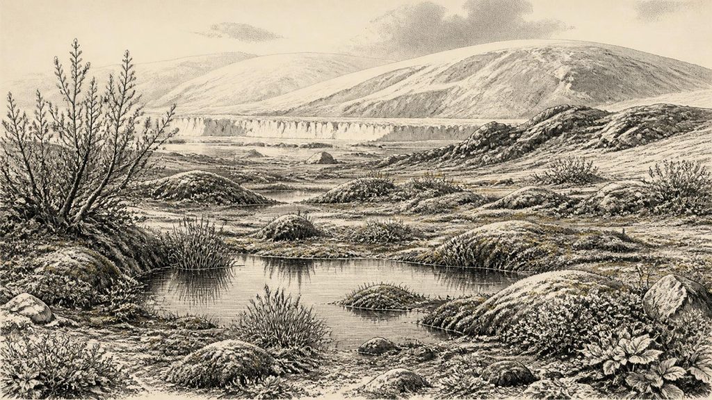
30,635 BCE is a modern label, not a date tied to an Irish event. During unstable Marine Isotope Stage 3, Ireland’s evidence is environmental and fragmentary. At Derryvree, County Fermanagh, organic freshwater sediments beneath tills, dated BIRM-166 to about 30,500 radiocarbon years BP, record a cold, treeless wetland between ice advances, with dwarf willow, sedges, mosses and aquatic life. Castlepook Cave, County Cork, preserves a long, re-dated assemblage of mammoth, giant deer, reindeer and predators. A possibly tool-marked reindeer bone suggests unconfirmed human visitation. Shifting ice, coastlines and uncertain routes preclude claims of settlement, land bridges or precise island-wide conditions.
Dateline
30,635 BCE is a modern chronological label, not a recoverable Irish year. It falls roughly 32,584 years before AD 1950, the conventional reference point for ‘before present’ dating, but that arithmetic does not convert it into a securely identifiable moment in the Late Pleistocene. No Irish calendar, named community, settlement horizon or historical event can be assigned to this year. The responsible subject is Ireland during Marine Isotope Stage 3 (MIS 3): a long, climatically unstable part of the last Ice Age, before the fullest expansion of the Last Glacial Maximum. What survives is a difficult, discontinuous record of tills, freshwater sediments, fossil plants, insects, cave bones and later scientific re-dating.
The evidence does not support a conventional political history. There are no known rulers, polities, diplomatic contacts, battles, monuments, cult places, farms, trade networks or written traditions in Ireland that can be placed at this date. Nor is there a securely excavated Irish camp with hearths, stone tools and associated human remains from around 30,635 BCE. The story is instead one of environmental opportunity and constraint: episodes of ice advance and retreat, open ground and wetland, animal movement, and perhaps very occasional human visitation at Europe’s north-western edge.
Dating a Deep Past
Precision is especially misleading here. Radiocarbon ages are measured in radiocarbon years, not calendar years, and their conversion requires calibration against changing atmospheric carbon-14. IntCal20 provides a Northern Hemisphere calibration curve extending back to 55,000 calendar years before present, but uncertainty increases markedly at this age. A precise-looking BCE label should therefore be treated as a filing point within a much wider chronological landscape, not as an anniversary.
The most celebrated Irish environmental sequence of roughly comparable antiquity comes from Derryvree, near Maguiresbridge in County Fermanagh. Roadworks in 1969 cut through a drumlin and exposed freshwater silts, fine sands and organic deposits sealed between two separate layers of till, the unsorted sediment deposited by glacier ice. The stratigraphic order is powerful evidence: ice had occupied the locality; a period without overriding ice allowed water, mineral sediment and organic matter to accumulate; then another ice advance buried the basin. The organic material produced the determination BIRM-166, 30,500 radiocarbon years BP, with a wide published uncertainty of +1,170 and −1,030 years.
That measurement must not be equated directly with 30,635 BCE. A later compilation gives the Derryvree result an approximate calibrated age of 35.9 ± 1.1 thousand calendar years BP; the precise range depends upon the calibration method and probability chosen. Derryvree is thus best used as an earlier MIS 3 environmental window, rather than claimed as a record of conditions in this exact nominal year. It is valuable precisely because it demonstrates how misleading a simple story of an Ireland continuously sealed beneath ice would be.
A Fermanagh Wetland Between Glaciers
Derryvree’s organic bed represents a cold, treeless freshwater setting, often described in older Irish Quaternary terminology as a muskeg or tundra wetland. Plant remains include sedges and grasses, mosses, dwarf willow, mountain avens, bogbean and lesser clubmoss; aquatic evidence includes water-milfoil. Insect remains point to shallow pools, wet vegetation and open ground. Together, these finds support a periglacial landscape shaped by severe winter cold, frost action and short growing seasons rather than woodland or a temperate meadow. They do not establish the exact extent of any one habitat across the island.
At a human scale, such a place would have been intensely seasonal. Water could gather in hollows when thaw and runoff permitted; low plants and mosses could exploit brief summers; exposed soil was vulnerable to freezing, solifluction and wind. There is no basis for imagining the modern Fermanagh lakeland, its forests, fields or settled townlands. Even the familiar names are conveniences of modern geography. Derryvree was a small basin in a changing ice-age terrain, not a weather station for all Ireland.
Its importance also lies in preservation. Later glaciers commonly eroded, reworked or concealed earlier land surfaces. An organic layer trapped beneath a drumlin is consequently an exceptional archive. It records local conditions during an interval when ice did not cover that hollow, but it cannot prove that all of Ulster, still less every part of Ireland, was open at the same time. Irish Quaternary schemes use labels such as the Derryvree Cold Phase, but these should be understood as working stratigraphic frameworks rather than fixed and island-wide climatic episodes.
Caves, Carnivores and Herd Animals
County Cork offers another, quite different archive. Castlepook Cave, near Doneraile, is Ireland’s richest recorded cave site for vertebrate remains from the period leading up to the Last Glacial Maximum. More than 2,000 bones have been recovered. Its broad dated record extends from about 45,700 to 19,950 BP and includes woolly mammoth, giant deer, reindeer, brown bear and spotted hyaena, as well as later cold-stage animals such as Arctic fox, wolf and lemmings.
This fauna shows that Ireland could, at different times in the wider late-Ice-Age interval, sustain or receive large herbivores and their predators. Reindeer suggest open, cold-adapted grazing country; mammoth and giant deer reinforce the picture of varied non-woodland habitats; hyaenas, wolves and bears indicate a food web in which carcasses were contested, transported and consumed. But a cave bone assemblage is not a census of a single valley or a single season. Carnivores, water movement, excavation practices and the mixing of deposits all complicate the record. Castlepook is best understood as a long-used repository of animal remains, not a frozen tableau of life in 30,635 BCE.
Modern re-dating has made that caution more important. Improved pretreatment of bone samples showed that several earlier Castlepook radiocarbon measurements were too young, in some cases by thousands of radiocarbon years. The resulting revisions push elements of its fauna deeper into MIS 3 and suggest that animals including giant deer and spotted hyaena may have disappeared locally before the Last Glacial Maximum. A renewed excavation in 2022 likewise stressed that the older cave investigations had recovered abundant Ice Age fauna but had not demonstrated human occupation.
The Human Question
A reindeer femur from Castlepook has been publicised as bearing a deep mark interpreted by Ruth Carden as damage made with a sharp stone tool during butchery. If that interpretation is confirmed, it would be a remarkable sign that Upper Palaeolithic people handled a carcass in Ireland tens of millennia before the well-established post-glacial settlement record. It would imply a short-lived visit or hunting episode, not a known resident population.
The limits of the claim matter as much as its excitement. The bone derives from a cave complex with disturbed, time-mixed deposits; it was not recovered from an intact occupation floor alongside a hearth, tool assemblage, dwelling, human remains or refitting butchered bones. The date of an animal’s death does not automatically date a surface mark, and no securely dated Palaeolithic settlement is presently known in Ireland. For 30,635 BCE, the evidence therefore permits the possibility of human presence in the broader period, but not an invented tribe, camp, language, ritual or migration narrative.
Ice, Coasts and Connections
Ireland’s physical geography was changing on a scale unfamiliar today. The British–Irish Ice Sheet was dynamic before the Last Glacial Maximum, but its exact MIS 3 extent remains debated. Recent synthesis finds evidence for retreat–advance phases during MIS 3, while stressing that directly dated till units for these earlier episodes are lacking. It also concludes that the pre-MIS 2 ice sheet was smaller than its later Last Glacial Maximum counterpart, even if ice accumulation over Ireland and the Irish Sea Basin could at times have been substantial.
This uncertainty rules out simple maps of a wholly frozen or wholly habitable Ireland for the nominal year. Lower global sea level changed coastlines, but it does not by itself prove a dry land bridge linking Ireland to Britain. Research on late-Quaternary Irish Sea palaeogeography has long found no persuasive evidence for a southern Irish Sea land connection; any northern route proposed for much later periods was discontinuous and geographically constrained. For MIS 3, animal and possible human access routes remain a question of changing sea, ice and exposed terrain, not a settled fact.
What Can Be Said Responsibly
There were no evidenced political affairs or diplomacy in the historical sense, and no evidence from which to reconstruct religion, formal learning, farming, trade or permanent settlement. Everyday life can only be discussed conditionally: any people who reached Ireland would have required mobile cold-weather survival skills and access to fuel, shelter and animal resources, but this is an inference from the wider Upper Palaeolithic world, not a demonstrated Irish society.
The strongest history for this point is environmental. Ireland was part of a volatile North Atlantic borderland in which ice margins shifted, wetlands briefly developed, sparse Arctic-alpine vegetation colonised exposed ground, and large mammals and carnivores moved through suitable habitats. Derryvree’s buried freshwater deposits and Castlepook’s cave fauna preserve complementary fragments of that world. They illuminate an Ireland that was neither empty in ecological terms nor securely documented as a human homeland: a landscape repeatedly remade by ice, with its most revealing evidence preserved by accident beneath till and within limestone darkness.
Primary Sources
- A Middle Midlandian Freshwater Series at Derryvree, Maguiresbridge, County Fermanagh, Northern Ireland
- Figure 6.— The Subdivision of the Quaternary Period in Ireland
- Quaternary Field Study Group: Geology of the Derryvree and Maguiresbridge Area
- Irish Pleistocene Biostratigraphy
- The Irish Quaternary Fauna Project
- A Reconsideration of the Radiocarbon Dating of the Marine Isotope Stage 3 Fauna from Southern Ireland
- New Insights on the Fauna of Ireland's Younger Dryas and Early Holocene from Alice & Gwendoline Cave
- Castlepook Cave, County Geological Site Report
- 2022:564 – Castlepook Cave, Castlepook South, Cork
- The Timing and Magnitude of the British–Irish Ice Sheet Between Marine Isotope Stages 5d and 2
- British–Irish Ice Sheet and Polar Front History of the Goban Spur, Offshore Southwest Ireland Over the Last 250,000 Years
- Growth, Dynamics and Deglaciation of the Last British-Irish Ice Sheet: The Deep-Sea Ice-Rafted Detritus Record
- New Data for the Last Glacial Maximum in Great Britain and Ireland
- BRITICE Glacial Map, Version 2: A Map and GIS Database of Glacial Landforms of the Last British–Irish Ice Sheet
- The IntCal20 Northern Hemisphere Radiocarbon Age Calibration Curve (0–55 cal kBP)
- IntCal Publications
- The Problem of a Late Quaternary Landbridge Between Britain and Ireland
- The Island of Ireland: Drowning the Myth of an Irish Land-bridge?
- Selaginella selaginoides
- Salix herbacea
- Menyanthes trifoliata
- Castlepook Caves
- Occurrence of Mammalia Relicts at Site Castlepook Cave