

BIRM-166 Freshwater Sequence30592 BCE
The label 30,592 BCE denotes a broad Late Pleistocene interval, not a recoverable Irish calendar year. At Derryvree, County Fermanagh, organic freshwater silts between tills record a locally ice-free, tundra wetland episode, radiocarbon dated Birm-166 and broadly calibrated to 36,900–31,700 years before present. Mosses, sedges, bogbean and other remains show cold but viable freshwater habitats before renewed glaciation formed drumlins. Castlepook Cave preserves a wider, time-averaged fauna including reindeer, mammoth and predators. A possibly cut-marked reindeer bone suggests, but cannot confirm, human visits. No contemporary settlement, tools or social history exists; Ireland’s evidence records shifting ice-margin environments and uncertain occupation.
Dateline
“30,592 BCE” is a modern chronological label, not a year that can be recovered from Ireland’s archaeological record. No Irish community then used a calendar, left writing, or created a securely dated settlement that can be assigned to a twelve-month interval. In the scientific convention of calibrated years before present, with “present” fixed at AD 1950, this label lies about 32,542 years ago. It belongs to the Late Pleistocene, broadly within Marine Isotope Stage 3 (MIS 3), an unsettled middle phase of the last Ice Age. The responsible history of Ireland at this point is therefore environmental and archaeological: a history assembled from buried sediments, fossils, landforms and uncertain traces of human activity.
A Date Range, Not an Annal
The closest and most informative Irish evidence is the Derryvree freshwater series near Maguiresbridge, County Fermanagh. Roadworks in 1969 cut through a drumlin and exposed a striking sequence. A lower deposit of till, unsorted debris laid down by glacier ice, was overlain by freshwater silts and fine sands rich in organic remains; another thick till later sealed the wetland. The sequence establishes a simple but important order: ice occupied the locality, then water and life persisted there during an ice-free interval, and ice subsequently returned or expanded across it.
Organic material from the Derryvree bed produced the radiocarbon determination Birm-166: 30,500 radiocarbon years before present, with a substantial quoted uncertainty of +1,170 and −1,030 years. A radiocarbon age is not a calendar age. Because atmospheric carbon-14 levels have changed through time, it must be calibrated against an independently constructed curve. Published discussion places the deposit broadly at about 36,900–31,700 calibrated years before present, approximately 34,950–29,750 BCE. The year-label considered here lies within that broad span, but it cannot identify the precise age of an individual seed, insect, pool or episode of sediment accumulation.
This limitation is the starting point rather than a defect. Derryvree does not tell us what happened in Ireland in one named year. It gives something more durable: direct evidence that, during a cold interval before the fullest expansion of the last British–Irish Ice Sheet, part of Fermanagh contained open freshwater habitat and tundra-like vegetation. Later ice preserved that record beneath the drumlin landscape.
A Wetland in a Cold Country
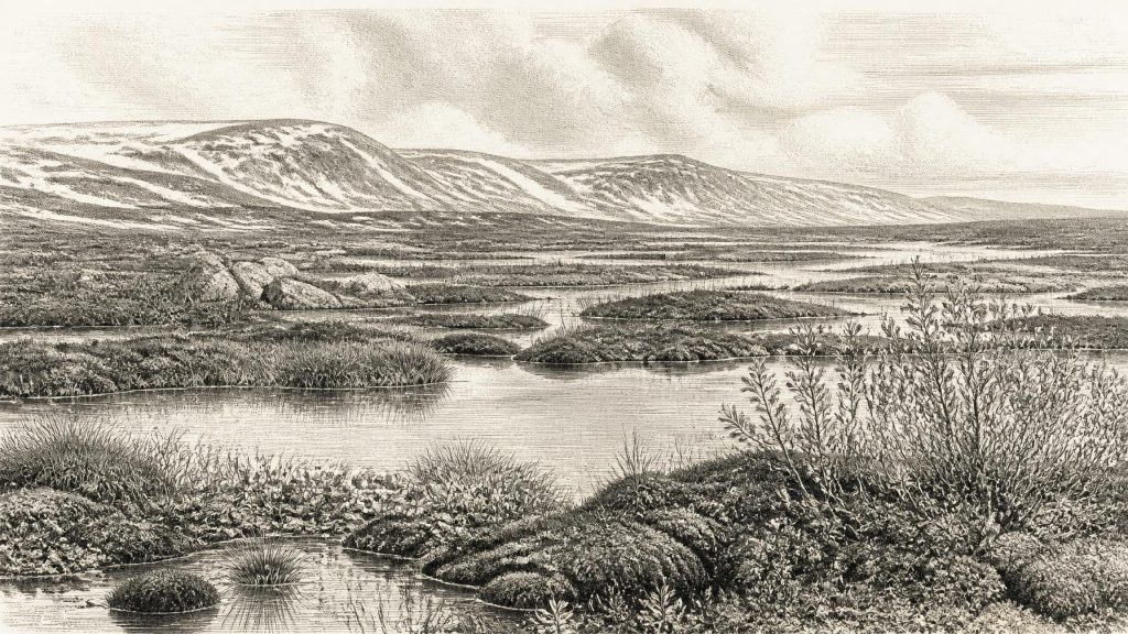
The organic silts at Derryvree contain plant and animal remains characteristic of a severe, treeless environment. Mosses, sedges and other wet-ground plants grew around shallow freshwater, while records of dwarf willow, mountain avens, bogbean and aquatic plants indicate a mosaic rather than a bare polar desert. Bogbean is particularly evocative: its presence points to standing or slow-moving fresh water, where a short growing season nevertheless permitted flowering plants and invertebrates to survive. The deposit has sometimes been described as a muskeg, a waterlogged, mossy tundra wetland. That term should not conjure an unchanging bog; the site was a dynamic place of silting pools, damp margins, seasonal freezing and thaw.
The evidence supports cold conditions, permafrost-related ground processes and a landscape exposed to powerful winds. It does not support a precise reconstruction of weather for 30,592 BCE. Summer sunlight could sustain plant growth in sheltered, wet hollows, while winters were probably long and severe. The contrast is important. “Ice Age” Ireland was not uniformly covered by glacier ice at every moment. At Derryvree, freshwater organisms and vegetation occupied a local opening between glacial episodes. Elsewhere, ice, snowfields, exposed gravel, periglacial slopes and open steppe-tundra may have formed very different local environments.
The island’s later scenery was already being prepared by these cycles. Moving ice eroded bedrock, shifted boulders and sediment, and reshaped drainage. When ice later advanced across Derryvree, it did not merely cover the wetland: it incorporated the area into the construction of the drumlin terrain for which Fermanagh is now famous. The preserved freshwater bed is thus a rare interruption in a landscape record otherwise dominated by glacial action.
Before the Ice Sheet’s Greatest Reach
This was not yet the best-defined maximum of the last British–Irish Ice Sheet. Research on the wider ice sheet indicates that maximum extents were reached asynchronously in different sectors, broadly between about 30,000 and 22,000 years ago, while the greatest overall ice volume came later, around 23,000 years ago. The exact pattern in Ireland remains actively studied because dating former ice margins is difficult and because older deposits have frequently been overridden, disturbed or removed by later glaciers.
For this reason, it is misleading to colour all Ireland either “ice-covered” or “ice-free” at 30,592 BCE. Derryvree proves a locally ice-free freshwater episode within its own broad date range. It does not prove that every coast, mountain and plain was open at the same time. Southern and western Irish evidence, including cave faunas and glacial landforms, confirms marked regional variation. The safer interpretation is of a country at an unstable margin: colder phases encouraged ice growth and contraction of habitable ground; milder intervals allowed wetlands, plants and animals to occupy suitable places.
Lower sea levels altered the geography beyond the present coastline, but no simple, securely dated land route into Ireland can be assumed for this particular moment. The Irish Sea basin was affected by changing sea level, marine ice and ice streams. Animals and any people who reached Ireland did so within a shifting north-west European world whose coastlines, barriers and corridors differed radically from those of today. The routes remain a question for research, not a known itinerary.
Animals of the Open Landscape
County Cork’s Castlepook Cave, near Doneraile, provides the principal Irish mammal archive relevant to this general part of the Late Pleistocene. Its deposits and old excavation collections have yielded remains of reindeer, woolly mammoth, giant deer, brown bear, wolf, Arctic fox, hare, lemmings and spotted hyaena. The Irish Quaternary Fauna Project demonstrated that a wide range of mammals reached Ireland between at least about 45,000 and 20,000 years ago. These dates encompass several climatic episodes; they do not mean that every species stood together at Castlepook, or at Derryvree, in 30,592 BCE.
Nevertheless, the fauna makes ecological sense alongside the Fermanagh wetland record. Reindeer and lemmings indicate cold, open country; Arctic fox and hare were adapted to similarly rigorous conditions. Mammoth and giant deer evoke a productive but treeless grassland-and-herb landscape in some regions, while wolves and hyaenas reveal a predator guild able to exploit large herbivores. Caves are not neutral sample boxes: carnivores could bring bones inside, water could move them, and early excavators did not recover deposits to modern standards. Castlepook is consequently best read as evidence of an Ice-Age animal community over time, not as a census for one day.
The Human Question
One Castlepook reindeer femur has acquired exceptional importance because a deep mark on it has been interpreted as a cut made by a sharp stone tool during butchery. The bone has been presented as possible evidence that people handled reindeer in Ireland around 33,000 years ago. If future microscopic, contextual and dating work confirms that interpretation, it would push the island’s known human story much further back than the better documented terminal-Pleistocene evidence.
For 30,592 BCE, however, caution is essential. No stone-tool assemblage, hearth, dwelling floor, burial, repeated occupation surface or securely excavated kill-site of this age is known from Ireland. A mark on one bone cannot establish a permanent population, the size of a hunting party, language, ancestry, seasonal movements or a settled homeland. It cannot be turned into an Irish “first family” or a foundation event. The evidence permits the possibility of short-lived human visits or hunting activity within the broader period; it does not demonstrate continuous settlement.
Society Beyond Recovery
Accordingly, political affairs, diplomacy and organised warfare cannot responsibly be described. There are no named peoples, chiefs, territories, alliances or institutions. Nor can religion, artistic tradition or formal learning be identified from the Irish evidence of this date. The absence is not proof that visitors lacked social lives, beliefs or knowledge. Mobile hunter-gatherers elsewhere in Ice-Age Europe possessed sophisticated practical skills, kin networks and symbolic cultures. It simply means that Ireland has not yielded evidence permitting those human realities to be reconstructed here.
If people entered the island during this broad period, their economy would have depended on immediate landscapes: knowledge of animal movements, fuel, shelter, water, stone and rapidly changing weather. Reindeer herds and other large mammals would have been valuable food resources, but hunting cannot be inferred from every animal bone. Trade is equally unrecoverable. No Irish artefact of this age demonstrates exchange with Britain or continental Europe. What can be said is that the animal and plant record places Ireland within a wider north-west European climatic zone, where ecological change linked the island to regions beyond its modern shores.
An Ireland Without Annals
The most important development around this notional date was neither a battle nor a dynasty, but environmental instability. At Derryvree, an open cold wetland existed long enough to accumulate silts, plant remains and small-animal evidence between episodes of glaciation. At Castlepook, animals occupied or were brought into caves over a long Late Pleistocene span. Across Ireland, expanding and retreating ice repeatedly erased, buried and rearranged the traces of earlier landscapes.
That is why this period is both obscure and compelling. Ireland was not an empty white space: freshwater pools supported bogbean and other plants; tundra and open country sustained animals; perhaps, though not yet securely demonstrated for this exact point, people sometimes entered this demanding world. Yet it was not a historical country in the later sense. Its story survives in a few fragile archives beneath tills and in cave bone collections, requiring interpretation rather than imaginative certainty. Derryvree’s buried marsh is the clearest witness: life persisted at the ice margin, but its chronology is measured in ranges, not calendar years.
Primary Sources
- A Middle Midlandian Freshwater Series at Derryvree, Maguiresbridge, County Fermanagh, Northern Ireland
- The Irish Quaternary Fauna Project
- Irish Pleistocene Biostratigraphy
- Growth and Retreat of the Last British–Irish Ice Sheet, 31,000 to 15,000 Years Ago: The BRITICE-CHRONO Reconstruction
- Growth and Retreat of the Last British-Irish Ice Sheet, 31 000 to 15 000 Years Ago: The BRITICE-CHRONO Reconstruction
- Exploring Controls of the Early and Stepped Deglaciation on the Western Margin of the British Irish Ice Sheet
- Last Glacial Maximum Cirque Glaciation in Ireland and Implications for Reconstructions of the Irish Ice Sheet
- Trimlines, Blockfields and the Vertical Extent of the Last Ice Sheet in Southern Ireland
- The Timing and Magnitude of the British–Irish Ice Sheet Between Marine Isotope Stages 5d and 2
- Stratigraphic and Palaeo-geomorphological Evidence for the Glacial-deglacial History of the Last British-Irish Ice Sheet in the North-western Irish Sea
- Geology of Ireland
- Quaternary
- Castlepook Cave: County Geological Site Report
- Archaeological Heritage of County Cork
- Heritage Artefacts of County Cork
- Archaeology Research Excavation Grant 2022: Final Report
- Castlepook Cave, Co. Cork, 2022
- New Insights on the Fauna of Ireland's Younger Dryas and Early Holocene from Alice & Gwendoline Cave
- New Insights on the Fauna of Ireland's Younger Dryas and Early Holocene from Alice & Gwendoline Cave
- The IntCal20 Northern Hemisphere Radiocarbon Age Calibration Curve (0–55 cal kBP)
- IntCal20 Issue
- Figure 6: The Subdivision of the Quaternary Period in Ireland


