
Water-Milfoil Between Tills30473 BCE
Around 30,473 BCE, Ireland experienced the unstable Late Pleistocene rather than a datable historical year. Derryvree in County Fermanagh preserves freshwater sediments between tills, showing a local ice-free wetland during Marine Isotope Stage 3. Its plants and insects indicate cold, treeless tundra-like conditions, with seasonal pools and vegetation. This evidence cannot establish island-wide conditions or a precise date. Castlepook Cave documents diverse cold-stage fauna, including mammoth, reindeer and hyaena, but its disturbed deposits span long periods. A possibly cut-marked reindeer bone suggests early human presence, yet does not prove settlement. Later ice reshaped landscapes and obscured evidence; uncertainty remains central.
Dateline
30,473 BCE is a modern chronological label, not a recoverable year in Ireland’s human past. No calendar used by people can be connected to this date; no Irish settlement, individual, conflict or seasonal event can be fixed to it. The responsible frame is the Late Pleistocene, during Marine Isotope Stage 3, when climate and ice margins around the North Atlantic altered repeatedly. The closest particularly informative Irish evidence is a freshwater deposit at Derryvree, near Maguiresbridge in County Fermanagh. Its calibrated age range includes this notional year, but the range is broad: the evidence can illuminate an interval, not a day, year or generation.
A Date Within a Wide Range
In 1969 roadworks cut through a drumlin at Derryvree and revealed a striking sequence. Beneath one thick sheet of till, sediment laid down by glacier ice, and above another, lay fine sands, silts and organic mud deposited in freshwater. The sequence demonstrates an important local history: ice had occupied the area; an interval followed in which water, plants and small animals inhabited a hollow; and later glacial activity buried and preserved that wetland beneath further sediment.
Organic material from the bed produced the radiocarbon determination BIRM-166, 30,500 radiocarbon years before present, with a substantial uncertainty of +1,170/−1,030 years. “Present” in radiocarbon convention means AD 1950, not the present day. Because atmospheric carbon-14 has varied through time, radiocarbon ages are not calendar ages and require calibration. Scholarship has placed the Derryvree deposit broadly at about 36,900–31,700 calibrated years before present, approximately 34,950–29,750 BCE; a later regional Bayesian model estimates an age of about 33,500 ± 1,200 years before present. Thus 30,473 BCE falls plausibly within the deposit’s broad chronological horizon, but cannot be assigned to a particular plant, pool or episode of sedimentation.
Fermanagh’s Cold Freshwater World
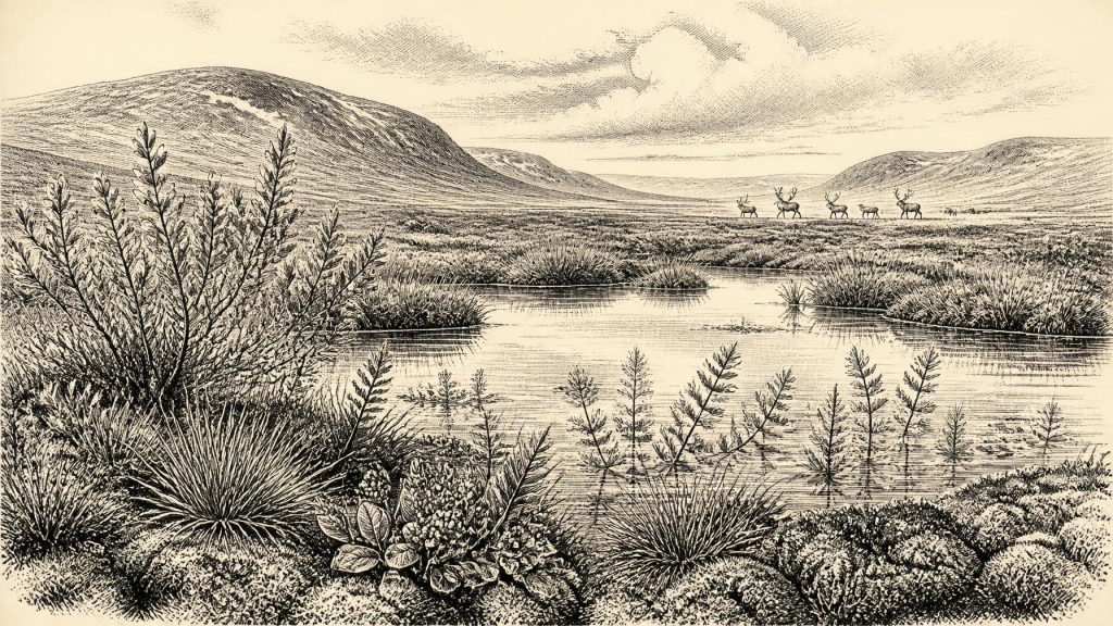
The Derryvree layer is direct evidence for local ice-free ground and freshwater conditions between glacial episodes. Its biological remains point to open, treeless vegetation under a periglacial regime: a severe climate in which frost, seasonal thaw, saturated soil and short growing seasons mattered more than familiar distinctions between field, woodland and lake. This was not an unbroken desert of snow and ice. Nor was it a temperate landscape resembling modern Fermanagh.
Plant macrofossils, pollen, mosses and insect remains allow a careful reconstruction of a wetland mosaic. Sedges and grasses grew on damp margins. Mosses occupied saturated ground. Dwarf willow, mountain avens and lesser clubmoss indicate cold-adapted or arctic-alpine conditions in suitable microhabitats. Bogbean and water-milfoil show that shallow freshwater and wet ground were present. These plants are evidence of particular ecological opportunities around the basin; the broader description of tundra wetland is an interpretation based on their requirements, the sediments and the enclosing tills.
At human scale, the landscape would have been intensely seasonal. Snowmelt and runoff could feed pools and slow water during the thaw. Low vegetation could take advantage of a brief summer, while frozen ground, wind exposure and winter darkness imposed severe constraints. The modern pattern of wooded shorelines, improved pasture, roads and townlands belongs to a vastly later world. Even the name Derryvree is only a modern geographical convenience for a place that had no recorded human name at this time.
Ice, Climate and an Uneven Island
Derryvree’s significance lies partly in its position between two tills. It proves neither that all Ireland was ice-free at once nor that an island-wide thaw occurred in a single neat phase. Glaciers can expand, retreat and leave isolated habitable areas under conditions that vary greatly by altitude, coast, drainage basin and proximity to ice. The surviving evidence is especially patchy because later ice scoured, redeposited and concealed older landscapes.
The wider climatic context was unstable. Greenland ice-core records identify abrupt switches between colder stadials and relatively milder interstadials across the last glacial period. Irish cave calcite deposits and rare organic sediments show that such variability affected the Atlantic fringe too, although they cannot yield an Irish weather record for 30,473 BCE. The Derryvree wetland is therefore best understood as a local archive of an unsettled climate rather than proof of uniform conditions across the island.
The principal Late Glacial Maximum of the British–Irish Ice Sheet was still to come. Its maximum extent is generally placed after this horizon, around 27,000 years before present, with extensive ice continuing through the following millennia. That later ice reshaped Ireland’s terrain and helps account for the scarcity of older archaeological evidence. A buried freshwater bed within a drumlin is valuable precisely because it escaped complete destruction, carrying traces of life from a landscape that was later overridden.
Animals in the Southern Caves
Castlepook Cave near Doneraile, County Cork, provides the other major Irish point of reference, though not a precise counterpart to Derryvree. The cave contains Ireland’s richest known assemblage of vertebrate remains from the period leading up to the Last Glacial Maximum. Its deposits and old excavated collections have produced evidence, accumulated across a long span rather than in one moment, for woolly mammoth, giant deer, reindeer, brown bear, wolf, Arctic fox, hare, lemmings and spotted hyaena.
These animals establish that, at intervals during Marine Isotope Stage 3, Ireland supported a far more varied cold-stage fauna than its modern mammals suggest. They also reveal the limitations of cave evidence. Many Castlepook bones were excavated before modern recording standards, and cave deposits were disturbed by water, animals and earlier digging. Modern redating has shown that some older determinations underestimated the age of bones by thousands of radiocarbon years. The cave is consequently a time-averaged faunal archive, not a snapshot of one community in 30,473 BCE.
Spotted hyaena are especially important to interpretation. They could accumulate and modify carcass remains, while water could move bones from their original position. A bone in a cave does not automatically mean that an animal died there, still less that people hunted it there. The evidence supports a dynamic food web of herbivores, predators, scavengers and shifting habitats; it does not permit a detailed reconstruction of one hunt, herd migration or season.
The Human Question
A reindeer femur from Castlepook has brought this distant period into Irish archaeological debate. It has been reported as approximately 33,000 years old and bears a deep mark interpreted by palaeozoologist Ruth Carden as a cut made by a stone tool during butchery. If that interpretation is sustained through continuing study, it would be evidence that people handled and processed a reindeer in Ireland far earlier than previously accepted.
Yet the distinction between possibility and proof matters. The bone itself dates the animal’s death, while identifying a surface incision as a stone-tool cut mark requires separate taphonomic judgement. Nor does one marked bone demonstrate a permanent settlement, a campsite, hearth, stone-tool industry, burial ground or repeated occupation. It cannot tell us whether people killed the animal, scavenged it, processed it in the cave or brought a portion of carcass there. The currently secure evidence for Late Palaeolithic human activity in Ireland remains much later: cut marks on a brown-bear bone from Alice and Gwendoline Cave, County Clare, dated to the Late Glacial Interstadial.
No Polities, No Recorded Beliefs
There is no evidence for political institutions, rulers, diplomacy, warfare, territorial boundaries or named communities in Ireland at this date. Terms such as kingdom, tribe or nation would impose much later ideas on a record that cannot sustain them. Likewise, there is no direct Irish evidence for language, religious observance, art, formal learning or ceremonial life. Continental Europe preserves remarkable Upper Palaeolithic material culture and symbolic practices, but importing them wholesale into Ireland would be analogy rather than Irish evidence.
The same caution applies to economy and trade. There is no demonstrated agriculture, herding, pottery, metalworking, monument building or exchange network. Derryvree’s plants were wild; Castlepook’s bones record wild animals. If small groups of people occasionally reached Ireland, they would have needed acute knowledge of weather, water, animal behaviour and shelter. That is a reasonable ecological inference, not a documented Irish society. Whether a land connection, sea crossings or changing coastal corridors enabled any such movement remains unresolved for this exact interval.
An Environmental, Not Annual, History
The most important development around 30,473 BCE was not a political event but the temporary existence of habitable environments between ice advances. In Fermanagh, a freshwater wetland supported plants, insects and other small life amid open cold-country vegetation. Elsewhere, the faunal record shows that large mammals could occupy Irish landscapes during parts of the later Ice Age. Cave deposits hint that people may also have entered that world, but do not yet establish a settled population.
This is Ireland before history in the conventional sense, but not before evidence. Sediments, fossils, stratigraphy and radiocarbon measurements provide a disciplined, if fragmentary, account: an ecologically varied island-edge landscape, repeatedly transformed by climate and ice; animal communities moving through it; and the still unresolved possibility of fleeting human visits. The uncertainty is not a gap to be filled with invention. It is the central historical fact of this extraordinarily distant Irish horizon.
Primary Sources
- A Middle Midlandian Freshwater Series at Derryvree, Maguiresbridge, County Fermanagh, Northern Ireland
- Exploring Controls of the Early and Stepped Deglaciation on the Western Margin of the British-Irish Ice Sheet
- A Reconsideration of the Radiocarbon Dating of the Marine Isotope Stage 3 Fauna from Southern Ireland
- Castlepook Cave: Cork County Geological Site Report
- The Irish Quaternary Fauna Project
- Episodic Speleothem Deposition Tracks the Terrestrial Impact of Millennial-Scale Last Glacial Climate Variability in SW Ireland
- The Timing and Magnitude of the British-Irish Ice Sheet Between Marine Isotope Stages 5d and 2
- Pattern and Timing of Retreat of the Last British-Irish Ice Sheet
- Pleistocene Glaciations in Ireland
- The IntCal20 Northern Hemisphere Radiocarbon Age Calibration Curve (0–55 cal kBP)
- IntCal History
- A Stratigraphic Framework for Abrupt Climatic Changes During the Last Glacial Period Based on Three Synchronized Greenland Ice-Core Records
- New Insights on the Fauna of Ireland’s Younger Dryas and Early Holocene from Alice & Gwendoline Cave
- The Mesolithic in Ireland: When Was It?
- Heritage Artefacts of County Cork
- Castlepook Cave, Castlepook South, Cork: Excavation Report 2022:564
- Irish Caves Database: Mammoth Cave
- Oscillating Retreat of the Last British-Irish Ice Sheet on the Continental Shelf Offshore Galway Bay, Western Ireland
- Sedimentology and Chronology of the Advance and Retreat of the Last British-Irish Ice Sheet on the Continental Shelf West of Ireland
- Deglacial Rates and Controls for the Western Margin of the British-Irish Ice Sheet
- The Colonization of Ireland: A Human Ecology Perspective