Maguirebridge’s Arctic Marsh31744 BCE
At the approximate horizon labelled 31,744 BCE, Ireland lay in late Marine Isotope Stage 3, approaching more extensive glaciation, rather than within a datable historical year. Derryvree, County Fermanagh, preserves freshwater silts between tills, indicating cold, open, periglacial wetlands with mosses, sedges and insects. Castlepook Cave, County Cork, contains MIS 3 remains of mammoth, reindeer, giant deer, bears, wolves and hyaena, demonstrating habitable terrain for large mammals. A possibly cut-marked reindeer bone suggests early human butchery, but cannot prove permanent settlement with certainty. Lower sea levels altered routes and coastlines; surviving evidence supports environmental reconstruction, not political or social history.
Dateline
Modern calendar-year precision is not available for Ireland in 31,744 BCE. No local calendar, written record, named ruler, settlement sequence or annually resolved natural archive can identify anything that happened in that particular year. Converted only as a modern chronological convenience, the label lies roughly 33,700 calendar years before AD 1950, within the later part of the Late Pleistocene and Marine Isotope Stage 3 (MIS 3). At this depth of time, the responsible historical unit is a broad, calibrated time-window of centuries or millennia, not a date in an annal.
The evidence that can illuminate Ireland around this horizon is unusually fragile: waterlogged silts beneath glacial deposits in County Fermanagh; animal bones, often from old cave excavations, in the limestone country of north Cork; pollen, mosses, seeds and insect remains; and the landforms left by advancing and retreating ice. These records are powerful, but they answer limited questions. They can show that parts of the island supported cold-climate plants and animals, and that ice was reshaping the region. They cannot securely supply a political history, a social map or a narrative of named people.
A Date Range, Not an Anniversary
Radiocarbon results are not calendar dates read directly from a specimen. They measure remaining radiocarbon and must be calibrated against independent records of past atmospheric carbon-14. The internationally used IntCal20 curve extends this work to 55,000 calendar years before present, but uncertainty remains substantial in the distant past. A date such as 31,744 BCE should therefore be treated as an approximate point within a calibrated chronology, not as evidence for an event on an exact winter’s day or summer’s evening.
Ireland’s relevant archaeological period is the Midlandian glaciation, the Irish expression of the last Ice Age. More specifically, the date falls in a late MIS 3 world that preceded the full Last Glacial Maximum. The latter is generally placed much later, approximately 26,000–19,000 calendar years before present, though the British–Irish Ice Sheet did not grow in a single simple pulse. Modelling, offshore evidence and landform studies show a dynamic ice complex, with changing centres of accumulation and margins. Around the broad horizon represented by this article, conditions were worsening towards major glaciation, but Ireland should not be imagined as uniformly entombed beneath ice at all places and times.
Derryvree Beneath the Drumlin
The most evocative local evidence comes from Derryvree near Maguiresbridge, County Fermanagh. Roadworks in 1969 cut through a drumlin and revealed freshwater silts and fine sands sealed between two separate layers of till, the unsorted sediment deposited by glacier ice. The organic beds included plant and animal remains, then were buried by a later ice advance. They preserve a brief geological window into a landscape that glaciers subsequently concealed.
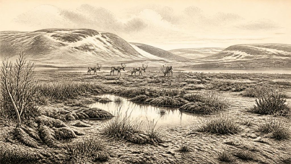
The original radiocarbon determination from the Derryvree deposit was 30,500 radiocarbon years before present, with a large uncertainty range. Calibrated dating places the deposit in a broad late-MIS-3 interval rather than at a single point; it is consequently relevant to, but does not date, 31,744 BCE itself. Its significance is environmental. Mosses, sedges, bogbean and other freshwater or wet-ground plants, together with pollen and insect evidence, indicate open vegetation and periglacial conditions. Periglacial does not mean permanently ice-covered: it describes a cold environment shaped by frost, seasonal freezing, sparse cover and processes operating around glaciers.
In this setting, low shrubs and herb-rich ground could occupy sheltered or wetter patches, while exposed terrain was likely open rather than forested. Freshwater pools, sedge margins and mossy ground made a varied small-scale habitat within a generally harsh climate. Yet Derryvree was one locality, not a weather station for the whole island. Its buried wetland should be used to illuminate north Fermanagh’s environment during a dated interval, not to impose an identical landscape on every Irish valley, coast and upland.
Castlepook’s Animal Archive
In County Cork, Castlepook Cave near Doneraile provides the principal faunal archive for Ireland before the Last Glacial Maximum. Also known as Mammoth Cave, it is a maze of limestone galleries excavated intermittently from the nineteenth century into the early twentieth. More than 2,000 bones were recovered. The assemblage includes woolly mammoth, reindeer, giant deer, brown bear, wolf, hare and spotted hyaena, alongside smaller cold-adapted mammals in later parts of the sequence.
These animals should not be pictured as an orderly herd living together on one afternoon. Cave deposits accumulate over long periods; bones can be dragged in by carnivores, washed or disturbed by water, moved during excavation, or derived from more than one episode. Re-dating and improved collagen pretreatment have shown that some older radiocarbon determinations for the southern Irish caves were too young. Modern reassessment places important Castlepook fauna securely in MIS 3, and indicates that some species, including spotted hyaena and giant deer, had disappeared locally before the Last Glacial Maximum.
Nevertheless, the animal record establishes an important fact: portions of Ireland were reachable and habitable for large mammals during this broad phase of the Ice Age. Reindeer point to open, cold-country grazing; mammoth and giant deer indicate that the available land supported substantial herbivore biomass at certain times; brown bears and wolves demonstrate a predator and scavenger guild beyond the modern Irish fauna. Spotted hyaena are particularly revealing. Their presence at Castlepook, the only securely known Irish locality for the species, helps explain why caves can contain mixed accumulations of prey remains: a cave was potentially a carnivore den and bone repository, rather than a human home.
The Unsettled Human Question
One reindeer femur from Castlepook has become central to discussion of Ireland’s possible earliest human activity. It bears a deep linear mark interpreted by zooarchaeologist Ruth Carden as a cut made by a sharp stone implement during carcass processing. The bone has been reported as approximately 33,000 years old in radiocarbon terms, placing its calibrated age broadly within the period under discussion. If the mark is anthropogenic, it would indicate that one or more Upper Palaeolithic people handled a reindeer carcass in Ireland far earlier than the formerly accepted post-glacial settlement record.
That is an important interpretation, not a settled foundation for a year-by-year history. The femur was recovered from an old cave collection, not from a modern excavation in an intact living floor alongside stone tools, hearths, food debris, structures or human remains. Cut-mark identification requires close assessment against natural abrasion, carnivore damage, breakage and later disturbance. New fieldwork at Castlepook has located surviving Pleistocene deposits in previously unexplored or undisturbed areas, offering the prospect of stronger contextual evidence. For now, the most careful conclusion is that the bone raises a serious possibility of very early human visits or butchery, while failing to demonstrate a permanent Irish population around 31,744 BCE.
What Cannot Be Claimed
There is no evidence for political communities, leaders, territorial boundaries, warfare, diplomacy, formal religion, monuments, art, schooling, farming, metalworking, domestic animals or trade networks in Ireland at this horizon. It would be misleading to invent hunter bands, tribal rivalries or spiritual practices merely because such subjects suit later historical categories. Even if people did reach the island, the evidence currently supports no more than brief and perhaps repeated visits by mobile foragers, probably enabled by lower sea levels and changing routes across the wider north-west European landscape. It does not reveal their language, kinship, beliefs or destination.
Nor can Castlepook be made into proof of a settled economy. The cave fauna tells us that animal resources existed and that carcasses entered the cave system; it does not establish regular hunting territory, exchange or seasonal camps. If people made the reindeer mark, the most economical inference is a single practical act of dismemberment or meat removal. Such an act would belong to a wider Upper Palaeolithic world in Britain and continental Europe, but Ireland’s record remains too sparse to identify a local cultural tradition.
An Island in Formation
The word “island” also needs care. Sea level during the Ice Age was much lower than today, exposing broad areas of the Irish Sea basin and changing the configuration of coasts, channels and possible land routes. Ireland’s modern shoreline did not exist. Connections with Britain and the European mainland varied with ice, sea level and local topography. Animal movement to Ireland during MIS 3 is therefore not surprising, but neither is it evidence that every crossing was easy or that human movement was continuous.
The defining development around this notional year was environmental instability. Freshwater wetlands at Derryvree, open cold-country vegetation, the mammals of Castlepook and the growing British–Irish Ice Sheet together depict an Irish landscape on the threshold of more extensive glaciation. Later ice would erode, bury and redistribute much of the evidence. That destructive legacy helps explain why the history of Ireland at 31,744 BCE is written chiefly in silts, bones and probabilities. It is not a blank past, but it is a past in which the most honest achievement is to describe the limits of what the surviving evidence can bear.
Primary Sources
- A reconsideration of the radiocarbon dating of the Marine Isotope Stage 3 fauna from southern Ireland
- A Middle Midlandian Freshwater Series at Derryvree, Maguiresbridge, County Fermanagh, Northern Ireland
- The Irish Quaternary Fauna Project
- Castlepook Cave: Cork County Geological Site Report
- The Geological Heritage of County Cork
- 2022:564 – Castlepook Cave, Castlepook South, Cork
- Mammoth Cave
- Occurrence of mammalia relicts at site Castlepook Cave
- Early Midlandian–Middle Midlandian, Pleistocene, Northern Ireland
- BRITICE Glacial Map, version 2: a map and GIS database of glacial landforms of the last British–Irish Ice Sheet
- Growth and retreat of the last British–Irish Ice Sheet, 31,000 to 15,000 years ago: the BRITICE-CHRONO reconstruction
- The IntCal20 Northern Hemisphere Radiocarbon Age Calibration Curve (0–55 cal kBP)
- Composition and consequences of the IntCal20 radiocarbon calibration curve
- IntCal Publications
- IntCal History
- New Insights on the Fauna of Ireland’s Younger Dryas and Early Holocene from Alice & Gwendoline Cave, County Clare
- The Brown Bear (Ursus arctos L.) in Ireland
- Ireland’s Palaeolithic Archaeology – Fleeting Footprints in a Frozen Land
- References and Recommended Reading: IQUA Field Guide 16
- Anthropogenic changes to the Holocene nitrogen cycle in Ireland
