Derryvree’s Cold-Stage Wetland31696 BCE
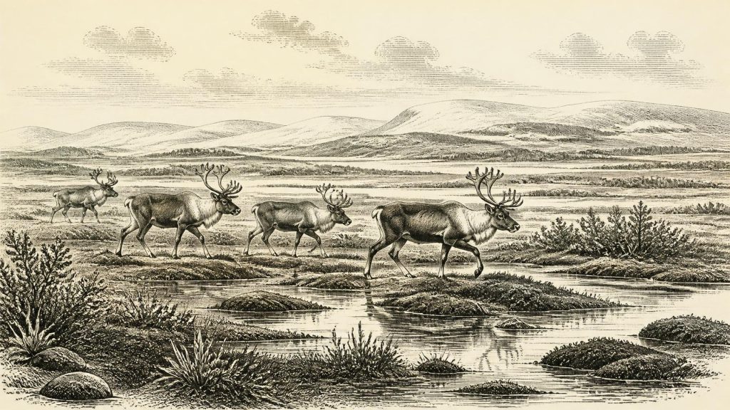
Around 31,696 BCE, a nominal date within uncertain calibrated ranges, Ireland lay in the climatically unstable MIS 3 Ice Age. At Derryvree, County Fermanagh, organic sediments between glacial tills record an ice-free interval of cold, treeless wetland, with sedges, mosses, herbs, shallow water and frost-disturbed ground. Castlepook Cave, County Cork, preserves remains of cold-adapted mammals, demonstrating intermittent ecological connectivity with north-west Europe. A marked reindeer femur may indicate Upper Palaeolithic butchery, though no secure camp or continuous occupation is known. Later ice expansion erased much evidence. The period is directly understood through environmental archives, not dated events, societies or politics.
Dateline
Modern calendar-year precision is not available for Ireland in 31,696 BCE. This is a retrospective label, not a year that anyone then named, recorded or could have recognised. In the archaeological convention of calibrated years before present—where “present” means AD 1950—it lies approximately 33,645 years ago. That conversion is only a guide: radiocarbon determinations at this depth of time must be calibrated and expressed as probability ranges, not treated as anniversaries. The relevant setting is the Late Pleistocene, within Marine Isotope Stage 3 (MIS 3), a climatically unstable part of the last Ice Age.
No Irish chronicle, monument, settlement, cemetery or securely dated human camp identifies an event in this particular nominal year. The evidence is instead environmental: sediments lodged beneath later ice, microscopic pollen, plant remains, insects and animal bones. These archives allow a cautious account of conditions across broad spans of centuries or millennia. They cannot tell us who governed Ireland, whether anybody lived there continuously, or what occurred in one season around 31,696 BCE.
A Date Within a Range
The distinction between radiocarbon years and calendar years matters especially here. Atmospheric carbon-14 has not remained constant through time, so a laboratory radiocarbon result is not automatically a calendar age. The internationally maintained IntCal20 calibration curve extends to 55,000 calendar years before present, but uncertainty increases greatly in this older portion of the record. A date written as 31,696 BCE should therefore be read as a place in a very long sequence, not as a sharply defined historical moment.
Its closest useful Irish comparison comes from Derryvree, near Maguiresbridge in County Fermanagh. Roadworks in 1969 exposed organic freshwater silts and fine sands enclosed between two layers of glacial till within a drumlin. The sequence produced a conventional radiocarbon age of 30,500 BP, with a large stated uncertainty. Later calibration places its possible age broadly at about 36,900–31,700 cal BP. The nominal date considered here falls within that broad range, but it does not date any individual plant, animal, journey or human action at Derryvree.
The order of deposits is nonetheless highly informative. An earlier glacier laid down the lower till. During an interval when the immediate locality was ice-free, freshwater and organic sediment accumulated. A later ice advance covered and preserved the deposit beneath the upper till. This is firm evidence of changing glacial conditions in south Fermanagh. It is not a map of the whole island at one instant: ice margins, local drainage, elevation and exposure could all have made Ireland environmentally varied.
Wet Ground on an Open Plain
Derryvree offers the clearest picture of an Irish landscape plausibly relevant to this horizon. Its pollen, plant macrofossils, mosses and insect remains point to a cold, open and predominantly treeless environment. Grasses, sedges, herbs, low shrubs and mosses occupied ground where they could survive short summers, hard winters and frost-disturbed soils. The record includes bogbean, a plant associated with wet ground, while the wider assemblage has been interpreted as tundra or muskeg-like terrain: saturated mossy patches, sedgy margins and shallow freshwater pools amid more exposed ground.
This was not uniformly barren country. A wetland capable of preserving plant matter and supporting insects was biologically productive at a small scale. Yet it was not the later wooded Ireland familiar from Holocene pollen records, nor a landscape of permanent fields. Trees, if present at all locally, were scarce. The most defensible reconstruction is a patchwork of cold-steppe and tundra-like vegetation, fresh water and frost-affected soil, shaped by a severe continental climate and by proximity to expanding or fluctuating ice.
MIS 3 was not one unchanging freeze. Greenland ice-core records and wider North Atlantic evidence show repeated, abrupt climatic oscillations on millennial scales. Those shifts did not translate simply into an Irish thermometer reading, but they caution against imagining one stable “Ice Age climate”. The Derryvree deposit records conditions over a span of accumulation; it cannot establish the exact temperature, snowfall, coastline or extent of vegetation in 31,696 BCE itself.
Animals and a Connected World
In southern Ireland, the limestone caves at Castlepook near Doneraile, County Cork preserve the island’s richest known assemblage of pre-Last Glacial Maximum vertebrate remains. The cave archive includes animals associated with a cold, open world: reindeer, woolly mammoth, giant deer, mountain hare, Arctic lemming, foxes, wolves, brown bear and spotted hyaena. Not every species need have occupied Cork at the same time. Cave deposits can accumulate through repeated use by carnivores, through animals falling or sheltering inside, and through water and sediment moving bones between layers.
Modern direct radiocarbon dating has revised parts of this collection. A 2020 reassessment concluded that some southern Irish fauna was substantially older than earlier measurements had indicated, placing important material in MIS 3 and suggesting that giant deer and spotted hyaena may have disappeared locally before the Last Glacial Maximum. The central point for this date is secure: Ireland was not ecologically isolated from north-western Europe throughout the earlier last glacial cycle. Cold-adapted mammals reached parts of the island during phases when routes and habitats permitted.
How they arrived remains less certain. Sea level was lower than today, remodelling the Irish Sea basin and exposing larger coastal plains. But lowered sea level alone does not prove a simple, continuous land bridge from Ireland to Britain or the continent; the route depended on local bathymetry, ice, water and the timing of sea-level change. Animal movement may have followed temporary terrestrial corridors, coastal lowlands or ice-margin landscapes. The fossils demonstrate connectivity in ecological terms, not the exact path taken by a particular herd.
The Castlepook Human Question
One Castlepook object gives this period unusual archaeological importance: a reindeer femur, recovered from an older cave collection, has been directly dated to roughly 33,000 years ago and bears a deep mark interpreted by zooarchaeologist Ruth Carden as damage made by a sharp stone implement on fresh bone. If that interpretation is confirmed, it may be evidence that Upper Palaeolithic people butchered reindeer in Ireland during MIS 3—many millennia before the well-established post-glacial settlement record.
The qualification is essential. The bone was not recovered in a modern excavation from an intact living floor beside a hearth and stone tools. Its radiocarbon date dates the animal’s death, not automatically the moment of cutting; the identification of a single groove as a humanly made cut is a separate specialist judgement. No securely associated lithic assemblage, hearth, dwelling, burial, food-processing area or repeated occupation surface of comparable antiquity has yet been demonstrated at Castlepook. Ongoing work in the cave seeks stratified deposits that could test the proposition more decisively.
Accordingly, a brief human visit is possible, and the femur may preserve an exceptionally early trace of butchery. A resident population, a named hunting group or a settled Palaeolithic society cannot responsibly be inferred. The cave itself may have been used far more often by carnivores than by people. Absence of proven camps should not be transformed into certainty that no person ever reached Ireland, but neither does one contested bone establish continuous occupation.
What Cannot Yet Be Written
There is no evidence for political affairs, diplomacy or organised warfare in Ireland at this horizon. Nor can archaeology identify social rank, household size, kinship rules, language, music, ritual or formal religion. People elsewhere in Upper Palaeolithic Europe made sophisticated tools, art and social networks, but it would be unsound to import those achievements wholesale into Ireland without an Irish assemblage securely demonstrating them. The same restraint applies to economy and trade: hunting or scavenging of large mammals is conceivable if the Castlepook mark is anthropogenic, but there is no evidence for Irish exchange networks, farming, herding, metalworking or permanent settlement.
What can be said is both narrower and striking. Around the broad interval represented by 31,696 BCE, portions of Ireland supported life between episodes of glaciation. In Fermanagh, freshwater lay among open, frost-prone wetlands; in Cork, cave deposits record a changing cold-stage fauna. This was a regional frontier of the north-west European Ice Age, vulnerable to abrupt climatic change and to the later expansion of the British–Irish Ice Sheet. Its history survives not in kings or battles, but in a buried wetland, scattered bones and the difficult questions they still pose.
Approaching Greater Ice Cover
The date also sits well before the maximum extent of the last British–Irish Ice Sheet, which research places broadly around 27,000–23,000 years ago, with differing measures of maximum area and volume. Later ice would reshape much of Ireland, eroding older land surfaces, transporting sediment and obscuring the archaeological record. That destructive history helps explain why evidence for the deep Palaeolithic is so sparse. Derryvree is valuable precisely because later till sealed its fragile organic sediments rather than removing them altogether.
For this reason, the most important development is environmental rather than political: Ireland was a changing cold-stage landscape, not simply an island sealed beneath permanent ice. The Derryvree record establishes an ice-free interval with functioning wetland ecology; Castlepook shows that large mammals entered the island’s wider Ice Age world; and the marked reindeer femur raises, without resolving, the possibility of human presence. At 31,696 BCE, calibrated ranges and material evidence are the proper historical scale.
Primary Sources
- Palaeoecology
- A Middle Midlandian Freshwater Series at Derryvree, Maguiresbridge, County Fermanagh, Northern Ireland
- Irish Pleistocene biostratigraphy
- A reconsideration of the radiocarbon dating of the Marine Isotope Stage 3 fauna from southern Ireland
- Castlepook Cave, County Geological Site Report
- Archaeology Research Excavation Grant 2022: Final Report
- Ireland's Palaeolithic Archaeology – Fleeting Footprints in a Frozen Land
- Archaeological Excavations at Killuragh Cave, Co. Limerick: A Persistent Place in the Landscape from the Early Mesolithic to the Late Bronze Age
- New insights on the fauna of Ireland's Younger Dryas and Early Holocene from Alice & Gwendoline Cave
- The IntCal20 Northern Hemisphere Radiocarbon Age Calibration Curve (0–55 cal kBP)
- IntCal Publications
- IntCal History
- Growth and Retreat of the Last British–Irish Ice Sheet, 31,000 to 15,000 Years Ago: the BRITICE-CHRONO Reconstruction
- Pattern and Timing of Retreat of the Last British-Irish Ice Sheet
- Stratigraphic and Palaeo-Geomorphological Evidence for the Glacial-Deglacial History of the Last British-Irish Ice Sheet in the North-Western Irish Sea
- Timing and Pace of Ice-Sheet Withdrawal Across the Marine–Terrestrial Transition West of Ireland During the Last Glaciation
- Deglaciation Chronology of the Donegal Ice Centre, North-West Ireland
- Trimlines, Blockfields and the Vertical Extent of the Last Ice Sheet in Southern Ireland
- Late Pleistocene Chronostratigraphy and Ice Sheet Limits, Southern Ireland
- Dansgaard–Oeschger Events in Climate Models: Review and Baseline Marine Isotope Stage 3 Protocol
- BSBI: Menyanthes trifoliata
- Archaeological Survey
