

Birm-166’s Moss-Rich Mud31419 BCE
31,419 BCE is a label within a broad Pleistocene dating range, not a recoverable Irish year. At Derryvree, County Fermanagh, organic silts beneath later glacial till, including Birm-166, show a locally ice-free interval during Marine Isotope Stage 3. Mosses, sedges, grasses, plants and insects indicate cold, treeless, waterlogged tundra. Castlepook Cave, County Cork, preserves remains of mammoth, reindeer, giant deer and predators, although cave deposits are selective and mixed. A possibly cut-marked reindeer bone suggests brief human contact, not settlement. Later expansion of the British-Irish Ice Sheet buried deposits and reshaped landscapes, leaving sparse, local evidence of Ice Age habitats.
Dateline
The label 31,419 BCE is a modern chronological convenience, not a year that can be reconstructed in the manner of later Irish history. There was no written calendar in Ireland, no named community, ruler or recorded event, and no archaeological sequence resolves activity to a single year at this depth of time. Converted mechanically into the archaeological convention of years before AD 1950, it falls at approximately 33,368 calibrated years before present (cal BP). That conversion should not be mistaken for a precise date supplied by a prehistoric deposit. The responsible evidence consists of broad calibrated ranges, sediments, pollen, plant remains, insects, animal bones and glacial landforms.
Ireland at this notional point belonged to the Late Pleistocene, within Marine Isotope Stage 3, during the last Ice Age. It was not yet the Last Glacial Maximum, when the British-Irish Ice Sheet later spread across most of the island and adjacent continental shelf. The period was nevertheless cold, environmentally volatile and geographically unlike modern Ireland. Coastlines lay elsewhere, ice margins shifted, and the present political division of the island had no relevance. The strongest account is therefore one of landscape and evidence rather than conventional political history.
A Broad Dating Window
The nearest important Irish archive is Derryvree, near Maguiresbridge in County Fermanagh. Road works in 1969 cut through a drumlin and exposed a remarkable succession: glacial till below, organic freshwater silts and fine sands in the middle, and another thick till above. Till is the unsorted debris deposited by glacier ice. The sequence consequently records an earlier glacial advance, an interval in which ice no longer covered the site, and a later advance that buried and protected the freshwater deposits.
Organic material from the Derryvree bed gave the radiocarbon determination Birm-166, conventionally dated to 30,500 ± 1,170 radiocarbon years BP. Radiocarbon ages are not identical to calendar ages because atmospheric carbon-14 has varied over time. Modern calibration curves are essential, but even they yield broad ranges at this antiquity. Later syntheses place the Derryvree evidence broadly within roughly 36,900–31,700 cal BP, or about 34,950–29,750 BCE. The nominal year 31,419 BCE lies inside that wide window; it cannot identify a particular layer, season, generation or occurrence at Derryvree.
This distinction is crucial. Birm-166 demonstrates that north-central Ireland was ice-free during part of late MIS 3 and that freshwater life occupied a local basin before a renewed ice advance. It does not give a weather report for the entire island in one particular year. Nor does it prove that conditions in Fermanagh precisely matched those in Cork, Kerry, the western seaboard or the Irish Sea basin. Ireland’s glacial history was regional, episodic and shaped by local relief, drainage and proximity to ice.
Wet Tundra Between Glaciers
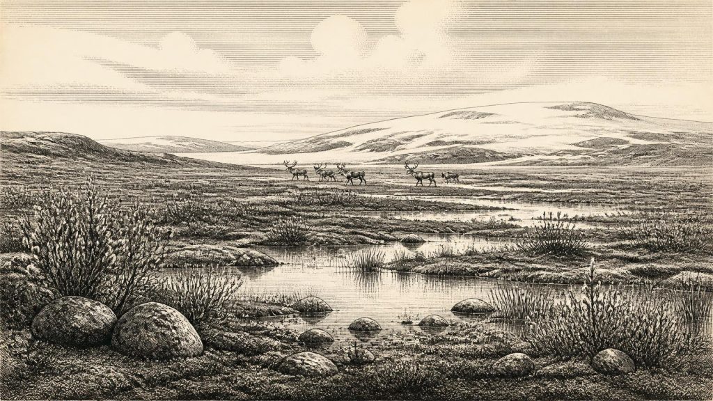
The Derryvree silts preserve a cold, open and periglacial environment. Periglacial means a landscape strongly governed by severe frost, freezing and thawing, seasonal snow and cold-ground processes, but not necessarily one covered by glacier ice. The evidence points away from woodland and towards tundra-like wetland: mosses, grasses, sedges, herbs and low-growing Arctic-alpine plants around shallow pools and waterlogged ground. The older term muskeg usefully conveys the mixture of mossy, saturated terrain, sedge-rich margins, standing water and accumulating organic mud.
Plant evidence from comparable Middle Midlandian deposits includes grasses and sedges, juniper, dwarf willow, mountain avens and lesser clubmoss. Such species and their fossil spores are valuable environmental indicators, but they do not create a complete botanical list for the whole island. A pollen grain can travel far, be redeposited from older sediment, or survive in a deposit after its source plant has disappeared. The firmer conclusion is that the Derryvree locality was largely treeless, open and cold, with enough water and summer growing season to sustain wetland vegetation.
Insects strengthen that interpretation. Beetle and other invertebrate remains can reveal whether ground was wet, vegetated, open or sheltered. At Derryvree they support an environment with plant-rich wetland, pools and mossy ground rather than a uniform desert of snow and bare rock. Yet this was no benign countryside. Winters were probably long and harsh; growing seasons were brief; exposed ground would have been vulnerable to frost disturbance. The later glacier that covered the deposit confirms that this was an interval within an unstable glacial world, not the beginning of a steady warming trend.
Animals in a Changing Country
County Cork provides another, very different, window onto broadly relevant conditions. Castlepook Cave, in the Awbeg Valley beneath the Ballyhoura Hills near Doneraile, has produced Ireland’s richest known assemblage of pre-Last Glacial Maximum large-mammal remains. Its collections include woolly mammoth, giant deer, reindeer, brown bear, spotted hyaena, wolf, Arctic fox, hare, stoat and lemmings. Not every specimen is of the same age, and a cave-bone collection is not a census of animals living together on one day. The cave accumulated material through varied processes, including carnivore activity, water movement and earlier excavators’ incomplete recording.
Even so, the fauna makes an important point. Parts of Ireland in the broad period could support cold-adapted herbivores and predators associated with open country. Reindeer and mammoth evoke wide-ranging grazing landscapes; lemmings and Arctic fox indicate severe climatic conditions; spotted hyaena and wolf underline that carcasses and caves belonged to predators as well as people. The landscape was not empty, but its animal populations were likely mobile, intermittent and sensitive to climatic swings. Modern ideas of permanent wildlife ranges or stable habitats cannot safely be projected backwards.
The animal evidence also reveals how selective preservation has been. Limestone caves are unusually favourable places for bone survival, whereas Ireland’s later glaciation, erosion and acidic soils destroyed or obscured much evidence from open-air sites. Castlepook is therefore exceptionally informative, but it is not representative in a simple statistical sense. Its abundance of fossils tells us as much about the preservation of caves as about the abundance of animals across all Irish regions.
The Question of People
Human history at this date is possible but unproven in the strong sense required for claims of settlement. A reindeer femur from Castlepook has been interpreted as carrying a mark made by a sharp stone tool on fresh bone, potentially the result of butchery. If that interpretation is upheld, it would indicate a short-lived Upper Palaeolithic human presence in Ireland around the wider period under discussion and would push the island’s human story far earlier than was once accepted.
That claim must remain carefully bounded. The femur was recovered from an old cave collection rather than a modern, securely excavated occupation floor. A date on bone indicates when the animal lived, not automatically the precise moment a mark was made. Cave deposits can be disturbed by water, frost, collapse, burrowing, carnivores and antiquarian excavation. Nor has a matching assemblage of stone tools, hearths, built shelters or stratified domestic debris been recovered to demonstrate a resident population. The evidence supports a possible episode of carcass processing, not a village, a continuous colony or a known migration route.
The people who might have visited, if the mark was indeed human-made, cannot responsibly be assigned a named ethnicity, language, social group or political identity. There is no evidence for chiefs, territories, alliances, diplomacy, warfare, ritual sites, art traditions or formal trade networks in Ireland at 31,419 BCE. Silence on these subjects is not a gap to be filled imaginatively: it is a result of the evidence. In this case, archaeology can suggest momentary contact with an animal landscape, but not a society’s institutions.
Livelihood Without an Economy
Likewise, no specifically Irish evidence demonstrates farming, stock-keeping, pottery, metalwork, weaving, long-distance exchange or permanent settlement at this time. Agriculture was many millennia in the future. If people entered Ireland during favourable intervals, their probable means of survival would have been hunting, scavenging, gathering and the transport of portable equipment, as among Upper Palaeolithic hunter-gatherers elsewhere in north-west Europe. That is a comparative inference, however, not a documented Irish economy.
Any movement into Ireland depended upon changing geography. Global sea level was lower during the wider Ice Age, exposing parts of the continental shelf and altering distances between land masses. But a lower sea level does not automatically establish a walkable land bridge from Ireland to Britain or continental Europe at this exact time. Ice, proglacial water, sea ice, marsh, rivers and shifting shorelines could all obstruct travel. The routes used by animals, and by any human visitors, remain an open question rather than a demonstrated corridor.
Approaching a More Extensive Glaciation
The Derryvree deposits matter partly because later ice sealed them. In the following millennia, the British-Irish Ice Sheet grew into a much more extensive system. Its maximum volume was reached around 23,000 years BP, while different sectors advanced and retreated at different times. The later ice transformed the terrain, excavated basins, redistributed sediment and helped erase earlier surface archaeology. Drumlins, tills, sands and moraines visible in Ireland today are parts of this long legacy, although most cannot be assigned to one short episode.
For 31,419 BCE, therefore, the most defensible picture is neither of an island wholly smothered in ice nor of a familiar green land awaiting settlement. It is of a changing north Atlantic margin where locally ice-free wet tundra existed during a broad interval, where large mammals moved through open habitats, and where ice later returned. Derryvree’s moss-rich mud preserves that fragile interval beneath the debris of a subsequent glacier.
What This Year Can Mean
A year-by-year history usually follows human decisions and recorded consequences. Here, the scale must be different. The evidence illuminates processes measured in centuries or millennia: climatic fluctuation, wetland formation, animal movement, ice advance and the rare preservation of organic matter. It supports the possibility of brief human contact with Ireland, but not a securely evidenced society. The most important development around this nominal year was the continued making and unmaking of habitable ground in an Ice Age Ireland whose archives are sparse, local and scientifically demanding.
Primary Sources
- A Middle Midlandian Freshwater Series at Derryvree, Maguiresbridge, County Fermanagh, Northern Ireland
- Irish Pleistocene Biostratigraphy
- Deglacial Rates and Controls for the British-Irish Ice Sheet Western Margin
- Growth and Retreat of the Last British-Irish Ice Sheet, 31,000 to 15,000 Years Ago: The BRITICE-CHRONO Reconstruction
- BRITICE Glacial Map, Version 2: A Map and GIS Database of Glacial Landforms of the Last British-Irish Ice Sheet
- Deglaciation Chronology of the Donegal Ice Centre, North-West Ireland
- The Deglaciation of the Western Sector of the Irish Ice Sheet from the Inner Continental Shelf to its Terrestrial Margin
- Stratigraphic and Palaeo-Geomorphological Evidence for the Glacial-Deglacial History of the Last British-Irish Ice Sheet in the North-Western Irish Sea
- A Reconsideration of the Radiocarbon Dating of the Marine Isotope Stage 3 Fauna from Southern Ireland
- Red Deer in Ireland: Phylogeography and Population History
- The Irish Quaternary Fauna Project
- Castlepook Cave, Co. Cork: Archaeology Research Excavation Grant 2022 Final Report
- 32564: Castlepook Cave, Ballyhooly, Cork
- Castlepook Cave
- Castlepook Caves
- New Insights on the Fauna of Ireland's Younger Dryas and Early Holocene from Alice & Gwendoline Cave
- Advances in Irish Quaternary Studies
- The Quaternary of Western Ireland: INQUA Field Guide Pre:GL-2
- The IntCal20 Northern Hemisphere Radiocarbon Age Calibration Curve (0–55 cal kBP)
- A Stratigraphic Framework for Abrupt Climatic Changes During the Last Glacial Period Based on Three Synchronized Greenland Ice-Core Records