

Derryvree’s Sealed Waters31178 BCE
31,178 BCE is a modern label within a broad Late Pleistocene range, not a datable Irish event. At Derryvree, County Fermanagh, freshwater sands and organic silts between glacial tills record an ice-free MIS 3 interval, later sealed by renewed ice. Fossils indicate cold, open wetlands with pools, mosses, sedges, herbs and tundra vegetation. Castlepook Cave, County Cork, preserves time-averaged remains of diverse mammals, including reindeer, mammoth, giant deer and predators, but not a single community. A marked reindeer bone may suggest human carcass processing, yet cannot prove settlement. Together, these fragmentary archives reveal climatically volatile, environmentally varied Ice Age Ireland.
Dateline
Modern calendar-year precision is not available for Ireland in 31,178 BCE. No written calendar, settlement sequence or archaeological layer can identify a particular Irish event, person or season in that year. The date is a modern label, roughly 33,127 years before AD 1950, within the Late Pleistocene and Marine Isotope Stage 3 (MIS 3), a climatically unstable part of the last Ice Age. A responsible account must therefore work with calibrated ranges, sedimentary sequences and probabilities rather than narrate an annual chronicle. Radiocarbon years and calendar years are not interchangeable, and calibration becomes especially broad at this depth of time.
A Date Within a Long Environmental Record
The most valuable Irish evidence close to this nominal date comes from Derryvree, near Maguiresbridge in County Fermanagh. Road construction in 1969 exposed a drumlin: a streamlined hill formed by glacial action. Within it lay fine freshwater sands and organic silts enclosed between two tills, the stony and unsorted sediments left directly by glacier ice. The sequence gives a firm relative history. An earlier glacial phase had deposited the lower till; an interval then followed in which freshwater sediments and organic remains accumulated; a later ice advance covered and sealed the deposit beneath fresh till.
The organic material yielded the radiocarbon determination BIRM-166, conventionally dated to about 30,500 radiocarbon years before present, with a large published uncertainty of roughly a millennium either side. When considered through modern calibration, the deposit is commonly placed broadly within c. 36,900–31,700 calibrated years BP. The calendar label 31,178 BCE falls inside that wide bracket, but it cannot be attached to an individual stratum, plant, insect or animal. Derryvree was not a one-day landscape preserved in mud. It was an environmental archive formed over an extended and changing interval.
This distinction is more than technical. It prevents the false impression that Ireland’s deep past can be treated like a medieval annal. What Derryvree securely demonstrates is that, during part of later MIS 3, this Fermanagh locality was free of overriding ice long enough for a freshwater and wetland environment to develop. It also demonstrates that this living landscape was later buried by renewed glaciation. It does not demonstrate the weather on a particular day in 31,178 BCE, nor prove that every part of Ireland had the same conditions.
Cold Wetlands Beneath the Drumlin
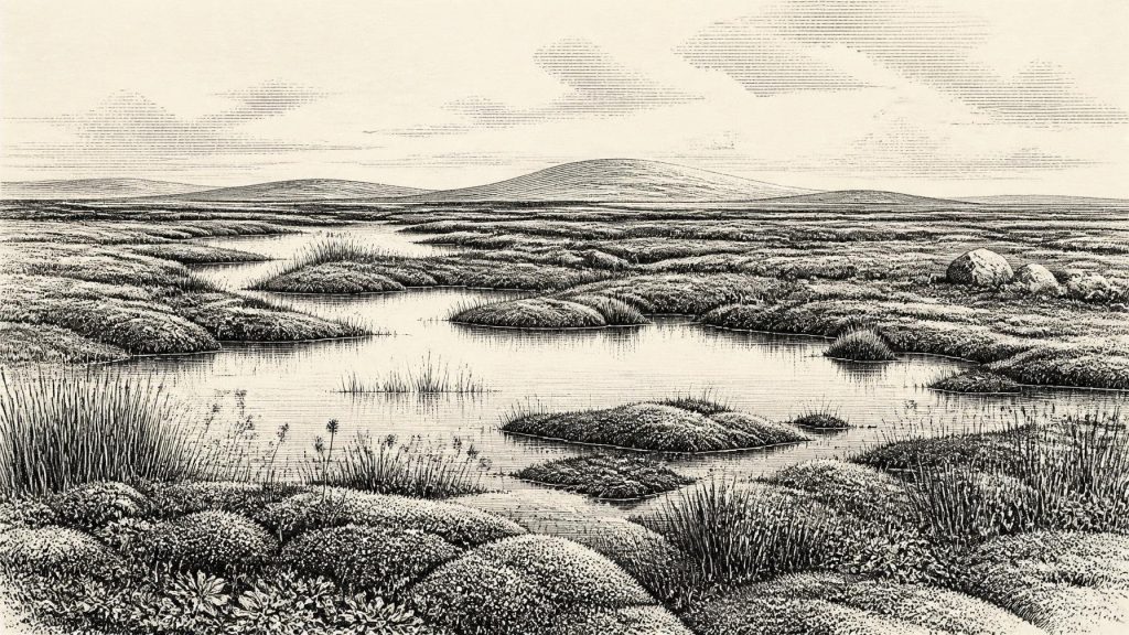
The Derryvree fossils point to a cold, open and largely treeless environment. Plant remains, pollen and invertebrate evidence indicate wet ground, shallow pools, mosses, sedges, herbs and low-growing tundra vegetation rather than forest. Bogbean, a wetland plant with distinctive trifoliate leaves, is among the significant botanical finds. Such evidence evokes a mosaic rather than an empty frozen plain: waterlogged hollows and freshwater margins could sustain specialised plants and insects, while exposed ground beyond them endured severe seasonal conditions.
‘Tundra’ should not be imagined as a uniform modern Arctic replica. The evidence supports a periglacial landscape shaped by cold, frost action and short growing seasons, but local relief, drainage, snow cover and the proximity of water would have created ecological variation. Mosses and aquatic plants tell us that certain protected or wet places were productive in summer. They do not imply extensive woodland, settled farmland or a stable climate. The vegetation was part of a dynamic Ice Age system in which relatively milder episodes could be followed by sharp cooling.
This was also a regional landscape in transition. The lower and upper tills at Derryvree indicate that the locality stood between episodes of ice cover. Across Ireland, glacial erosion and later sediment deposition have destroyed, disturbed or deeply buried many land surfaces of this antiquity. That helps explain why the surviving evidence is so fragmentary. Freshwater deposits protected beneath a drumlin are exceptional precisely because they escaped complete removal until modern roadworks exposed them.
Before the Greatest Ice Expansion
At this approximate point in time, Ireland was approaching, but had not yet reached, the maximum expansion of the last British–Irish Ice Sheet. The Last Glacial Maximum is generally placed much later, broadly between about 26,000 and 20,000 years ago, though the timing, thickness and extent of ice differed between regions and reconstructions continue to be refined. The Derryvree succession is important because it proves an earlier ice-free or non-glacial interval at that particular site before later glacial advance transformed the landscape again.
Sea level was lower than today because vast quantities of water were locked in northern ice sheets. Yet lower sea level alone cannot establish a straightforward land bridge, easy journey or permanent route into Ireland. The configuration of coasts, ice margins, channels and exposed shelf changed through time, while stormy seas and cold terrain imposed formidable barriers. For Ireland, the evidence is stronger for changing environmental connectivity with Britain and continental Europe than for any securely mapped route used at this exact date.
Castlepook and the Animal World
County Cork offers a different kind of evidence. Castlepook Cave, near Doneraile, has yielded Ireland’s most important pre-Last Glacial Maximum assemblage of large mammal remains. The cave deposits include material attributed to woolly mammoth, giant deer, reindeer, brown bear, wolf, Arctic fox, mountain hare, lemmings and spotted hyaena. This is compelling evidence that Ireland supported, at different times during the Late Pleistocene, a far broader mammal community than the later island fauna.
But the cave is not a neat snapshot of one herd or one season. Carnivores carried material into caves; animals may have died naturally; water moved sediments; and early excavations often lacked the recording standards expected today. Recent redating has shown that some older radiocarbon results from Castlepook and other southern Irish caves were substantially too young. The resulting lesson is methodological as well as chronological: a species list from a cave cannot automatically be treated as a contemporaneous community, still less be transferred without qualification to Derryvree in Fermanagh.
Even so, Castlepook makes the wider ecological setting intelligible. Reindeer and lemmings are consistent with cold open habitats; mammoth and giant deer indicate large herbivores able to move across broad landscapes; hyaena, wolf and bear show that predators and scavengers were also part of the food web. Their presence implies seasonal movement, predation and carcass use, but it cannot reveal annual migration routes or population sizes in Ireland. This was not an economy in the human historical sense. It was an animal world responding to vegetation, climate and access across a changing north-west European geography.
The Human Question
A reindeer femur from Castlepook has made this period especially significant. A deep mark on it has been interpreted as a cut or chop made with a sharp stone implement while the bone was fresh. If that interpretation is upheld, it may indicate that Upper Palaeolithic people handled a reindeer carcass in Ireland around this broad period. It would be an exceptionally early trace of human activity on the island, far older than Ireland’s better-established post-glacial human record.
The careful conclusion, however, must remain narrow. One marked bone is not a settlement, camp, hearth, tool assemblage, burial ground or proof of a permanent population. It does not establish whether people hunted the animal, scavenged it, removed hide or sinew, or processed meat elsewhere before a limb reached the cave. Nor does it demonstrate a continuous Irish population. The cave’s disturbed history means that the date of the animal, the origin of the mark and the depositional history must each be assessed separately.
Accordingly, political affairs, diplomacy, named communities, formal religion and organised trade cannot responsibly be described for Ireland in 31,178 BCE. There is no evidence for leaders, territories, languages, monuments, ritual sites or artistic traditions on the island at this date. If people were present, comparative evidence from Upper Palaeolithic Europe makes small, mobile foraging parties a plausible model, but that is an interpretation drawn from elsewhere, not a demonstrated Irish social order. The reindeer bone can support a question about human visitation; it cannot support a biography of Ice Age Ireland.
What This Year Can Mean
The most meaningful history of 31,178 BCE is therefore the history of a vulnerable landscape recorded by chance. In Fermanagh, freshwater silts beneath a drumlin preserve a cold wetland of pools, sedges, mosses, insects and sparse tundra vegetation. In Cork, cave deposits preserve a time-averaged record of animals that crossed or inhabited parts of Ireland during the Ice Age. Together they show that Ireland was neither an unchanging ice block nor a documented human homeland. It was an environmentally varied, climatically volatile edge of north-western Europe.
Renewed glaciation would later scour terrain, redirect drainage, bury older surfaces and remove much of the evidence that might once have recorded animal and human activity. Derryvree’s sealed waters survived because glacier-laid sediment enclosed them; Castlepook survived because limestone caves retained bones and sediments, however imperfectly. Their value lies not in supplying an invented event for a numbered year, but in allowing Ireland’s deeper prehistory to be described with appropriate precision, restraint and wonder.
Primary Sources
- A Middle Midlandian Freshwater Series at Derryvree, Maguiresbridge, County Fermanagh, Northern Ireland
- The IntCal20 Northern Hemisphere Radiocarbon Age Calibration Curve (0–55 cal kBP)
- IntCal Publications
- A Reconsideration of the Radiocarbon Dating of the Marine Isotope Stage 3 Fauna from Southern Ireland
- New Insights on the Fauna of Ireland's Younger Dryas and Early Holocene from Alice & Gwendoline Cave
- Advances in Irish Quaternary Studies
- Maximum Extent and Dynamic Behaviour of the Last British–Irish Ice Sheet West of Ireland
- Last Glacial Maximum Cirque Glaciation in Ireland and Implications for Reconstructions of the Irish Ice Sheet
- Dimensions and Chronology of the Last Ice Sheet in Western Ireland
- Introduction to the Late Quaternary and Holocene of Northern Ireland
- Figure 6.— The Subdivision of the Quaternary Period in Ireland
- The Irish Quaternary Fauna Project
- Radiocarbon Dates from the Oxford AMS System: Archaeometry Datelist 31
- Pleistocene Vertebrates in the British Isles
- Heritage Artefacts of County Cork
- Mesolithic – Iron Age
- The Mesolithic in Ireland: When Was It?
- Lateglacial Vegetation and Environment in Ireland: First Results from Four Western Sites
- A North-Western Habitat: the Paleoethology and Colonisation of a European Peninsula
- The Ecology, Subsistence and Diet of ~45,000-Year-Old Homo sapiens at Ilsenhöhle in Ranis, Germany