

Derryvree Between Tills30395 BCE
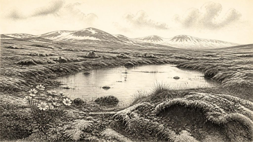
About 30,395 BCE, Ireland cannot be described through a precise historical year, but Derryvree, County Fermanagh, preserves evidence within a broad calibrated range. Freshwater silts and organic deposits, sealed between glacial tills, show a temporary ice-free wetland during the Late Pleistocene. Plant, insect and small-animal remains indicate treeless, cold, tundra-like mosaics of ponds, mosses, sedges and sparse herbs. Advancing ice was not yet at its maximum, and conditions varied regionally. Southern cave faunas demonstrate glacial animals, although mixed deposits resist exact dating. A possibly cut-marked reindeer bone from Castlepook may indicate fleeting human activity, not settled occupation or social history.
Dateline
30,395 BCE is a useful modern label, but it cannot be treated as a recoverable Irish calendar year. No written record, annual chronicle, settlement sequence or precisely dated event allows historians to say what happened in Ireland in that particular year. At this depth of time, the responsible approach is to place the date—roughly 32,344 years before the radiocarbon convention of AD 1950—within broad calibrated ranges and to distinguish physical evidence from interpretation. The relevant period is the Late Pleistocene, within Marine Isotope Stage 3 and the Midlandian cold stage: an unstable part of the last Ice Age, before the greatest expansion of the British–Irish Ice Sheet.
The strongest Irish evidence close to this notional date is not a human artefact or a named place of habitation. It is a buried freshwater deposit at Derryvree, near Maguiresbridge in County Fermanagh. Its survival beneath a drumlin makes it an unusually valuable, if necessarily local, witness to an Irish landscape that was repeatedly transformed by ice.
A Date Inside a Wide Window
In 1969, roadworks cut through the Derryvree drumlin and exposed a sequence of two distinct layers of glacial till, with freshwater silts, fine sands and organic material between them. Till is the unsorted mixture of clay, stones and other debris deposited directly by moving ice. The order of the layers is clear. Glacier ice had first occupied the site; afterwards, the locality was ice-free long enough for standing or slow-moving freshwater, sediment and vegetation to develop; later ice covered and sealed the deposit beneath a further till sheet.
Organic material from this intervening freshwater series produced the conventional radiocarbon determination BIRM-166: 30,500 radiocarbon years before present, with a large uncertainty of +1,170 and −1,030 years. That is not the same thing as a calendar age. Atmospheric carbon-14 has varied through time, so radiocarbon measurements must be calibrated against independently dated records. Modern discussion places the Derryvree deposit broadly at about 36,900–31,700 calibrated years BP, approximately 34,950–29,750 BCE. The requested date falls within that wide range, but it cannot be pinned to a particular stratum, season, plant, animal or human generation.
This caution is more than technical. A sediment bed may accumulate over centuries or longer; fossils may be redeposited; and one sheltered Fermanagh basin cannot serve as a weather station for the entire island. Nevertheless, Derryvree securely demonstrates that an ice-free freshwater environment existed locally during a period between glacial advances. It also preserves a rare ecological record from an Irish interval for which later ice, erosion and sediment movement have destroyed or obscured much evidence elsewhere.
Cold Water, Open Ground
The Derryvree plants and small animal remains describe a treeless, periglacial environment rather than the green, wooded Ireland familiar from later prehistory. Pollen was poorly preserved, but much of it came from herbaceous plants associated with tundra vegetation. Plant macrofossils, mosses and insects add more detail. They indicate wet ground, shallow freshwater and sparse vegetation able to withstand short growing seasons, winter cold, freeze–thaw action and exposed conditions.
Among the informative finds are remains of bogbean (Menyanthes trifoliata), a wetland plant, and alternative-leaved water-milfoil (Myriophyllum alterniflorum), an aquatic plant. Mountain avens (Dryas octopetala) is also recorded. These are not evidence for a continuous flower-rich carpet across Ireland, nor for a uniform climate. They do show that the Derryvree hollow held freshwater and its margins supported a specialised cold-climate flora. Mosses, sedges and low herbs would have formed much of the local cover, while drier ground may often have been bare, thinly vegetated or disturbed by frost.
The appropriate picture is therefore one of a mosaic: wet hollows and ponds, sedgy or mossy margins, open mineral soil and patches of low tundra vegetation. It was not necessarily an unbroken snowfield, but neither was it a forested island. Summer could allow rapid growth in sheltered places; winter and the long-term trend of climate imposed severe limits. This was a landscape in which water, ground ice and seasonal thaw were as important as trees are in later Irish environmental history.
Ice Was Gathering Strength
Derryvree’s lower and upper tills record repeated glacial intervention, but they do not make it possible to draw a single exact ice margin for 30,395 BCE. The wider British–Irish record shows why. Ice-sheet growth and maximum extent were asynchronous: different sectors advanced, stabilised and retreated at different times. Major reconstructions place the greatest volume of the last British–Irish Ice Sheet around 23,000 years ago, while its various sectors reached their maximum positions over a longer period, roughly 30,000–22,000 years ago.
Thus the date belongs to an approach towards the Last Glacial Maximum, not to the maximum itself. Some Irish areas may have been affected by growing upland ice or ice streams, while others retained exposed ground and freshwater basins for a time. The Derryvree sequence is especially important because it prevents a simplistic account in which Ireland was either entirely ice-covered or entirely open. Its message is one of change: glacial ice, an ice-free wetland interval, then renewed burial beneath ice-derived sediment.
Lower sea levels altered the geography beyond the modern coastline, exposing broad stretches of continental shelf. Yet exposed shelf should not automatically be called a land bridge, and it does not prove easy travel between Ireland, Britain and continental Europe at this moment. Coastlines, sea channels, ice fronts, winds and seasonal conditions all mattered. What can be said is that Ireland was part of a changing north-west European environmental zone, not an isolated version of its modern geography.
The Mammal Record and Its Limits
Caves in southern Ireland provide another, different kind of evidence. Castlepook Cave near Doneraile in north County Cork—also known as Mammoth Cave—has yielded one of Ireland’s richest Pleistocene vertebrate assemblages. Research has identified remains including woolly mammoth, reindeer, giant deer, brown bear, wolf, Arctic fox, lemmings and spotted hyaena. This assemblage establishes beyond doubt that animals now absent from Ireland reached or lived in parts of the island during the last glacial cycle.
It must not, however, be converted into a wildlife census for 30,395 BCE. Much of the material was recovered in early excavations, cave deposits are often disturbed, and bones accumulated through different episodes. Modern re-dating has shown that several earlier radiocarbon determinations from Castlepook and other southern caves were substantially too young, sometimes by thousands of years. Some elements of the Castlepook fauna belong to an earlier part of Marine Isotope Stage 3, while other cold-adapted animals are known from later phases. A mixed cave collection records a long history of animal use, carnivore activity, water movement and excavation—not necessarily creatures sharing one valley in one year.
Even so, the fauna makes ecological sense alongside Derryvree’s open vegetation. Reindeer and other grazing animals could exploit open ground; predators and scavengers followed animal populations or used caves as dens and refuges. Hyaena activity is particularly important because it can carry, gnaw, break and concentrate bones, complicating every interpretation of human involvement. Animal bones therefore reveal both a living food web and the processes that altered its remains after death.
A Possible Human Trace
The most provocative Irish object associated with this broad Ice Age horizon is a reindeer femur from Castlepook. Zooarchaeologist Ruth Carden has interpreted a deep linear mark on it as a cut made by a sharp stone tool during the processing of fresh bone. County Cork heritage material presents the find as broadly around 31,000 BCE, and public accounts have described the bone as approximately 33,000 radiocarbon years old. If the cut-mark interpretation is sustained, it would be evidence that people handled or butchered a reindeer in Ireland far earlier than the island’s formerly accepted terminal-Pleistocene evidence for human presence.
That is a major possibility, but a limited one. The bone is not a house floor, hearth, tool kit, burial, artwork or settlement. Its date concerns the animal’s death, while the interpretation of its mark depends upon close analysis of bone surface modification and context. Nor does one processed limb prove permanent occupation, a population size, a route of arrival, or a direct ancestral connection to later Irish communities. The careful conclusion is that the femur may preserve a fleeting human action in Ice Age Ireland; it does not yet provide a conventional narrative of an inhabited country.
No Polities, But Real Lives
There is no evidence for political institutions, chiefs, warfare, diplomacy, territorial states, formal religion, literacy, trade networks or named peoples in Ireland at this date. Nor is there evidence from Derryvree or Castlepook to reconstruct a settled village, domestic routine, language or ritual. Absence of such evidence should not be mistaken for evidence that any visiting people lacked culture. It means that the Irish record has not preserved the objects and contexts needed to discuss those subjects responsibly.
If people were present, the reindeer femur suggests only the most basic and defensible inference: a mobile party may have had knowledge of animal carcass processing and sharp stone implements. In the wider Upper Palaeolithic world, such skills belonged to highly adaptable hunter-gatherers, but Ireland has not yet produced a securely associated lithic assemblage from this horizon. Claims about seasonal camps, organised hunts, skin tents, kinship systems or exchange would therefore go beyond the evidence.
The principal development illuminated around 30,395 BCE is environmental. Ireland contained, at least in some localities and at some points within a broad calibrated span, freshwater wetlands amid a cold open landscape, while ice was advancing again on a regional scale. Plants, insects, sediments and animal bones record a land of mobility and instability. They offer no anniversary event, but they do reveal the deep conditions from which all later Irish history eventually emerged.
Primary Sources
- A Middle Midlandian Freshwater Series at Derryvree, Maguiresbridge, County Fermanagh, Northern Ireland
- A Reconsideration of the Radiocarbon Dating of the Marine Isotope Stage 3 Fauna from Southern Ireland
- The IntCal20 Northern Hemisphere Radiocarbon Age Calibration Curve (0–55 cal kBP)
- Growth and Retreat of the Last British–Irish Ice Sheet, 31,000 to 15,000 Years Ago: the BRITICE-CHRONO Reconstruction
- The Irish Quaternary Fauna Project
- Pleistocene Glaciations in Ireland
- Palaeoecology
- Figure 6.— The Subdivision of the Quaternary Period in Ireland
- Heritage Artefacts of County Cork
- Archaeological Heritage of County Cork
- Menyanthes trifoliata
- Myriophyllum alterniflorum
- Dryas octopetala
- The Mesolithic in Ireland: When Was It?
- First Evidence of a Late Upper Palaeolithic Human Presence in Ireland
- New Insights on the Fauna of Ireland’s Younger Dryas and Early Holocene from Alice & Gwendoline Cave
- The Tolsta Interstadial, Scotland: Correlation with D–O Cycles GI-8 to GI-5?
- Dynamic Cycles, Ice Streams and Their Impact on the Extent, Chronology and Deglaciation of the British–Irish Ice Sheet
- BRITICE-CHRONO: Constraining the Retreat of the Last British-Irish Ice Sheet
- 32564: Castlepook Cave, Co. Cork
- Introduction to the Glacial Sand and Gravel Landscapes of Northern Ireland
- The IntCal20 Northern Hemisphere Radiocarbon Age Calibration Curve (0–55 cal kBP)








