

Greenagho’s Tundra Basin31881 BCE
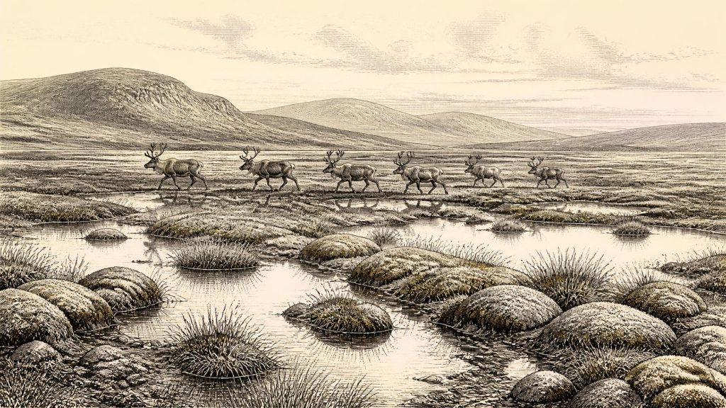
About 31,881 BCE, Ireland lay within the unstable cold conditions of Marine Isotope Stage 3, rather than a precisely datable historical year. Buried freshwater deposits at Derryvree and Greenagho, County Fermanagh, show that north-central areas were periodically ice-free before later glacial advances, supporting treeless, waterlogged tundra of mosses, sedges and shallow pools. Cave remains at Castlepook, County Cork, demonstrate intermittent connections to wider European fauna, including reindeer, mammoth, horse, predators and lemmings. Possible stone-tool marks on a reindeer bone suggest brief human visits, but cannot prove settlement. Expanding ice subsequently covered most of Ireland, preserving only valuable fragmentary environmental evidence.
Dateline
The label 31,881 BCE is a modern way of locating a point far beyond written history, not a date that anybody then living in Ireland could have named or recorded. At this depth of time, calendar-year precision is not archaeologically available. In conventional terms, the number corresponds roughly to 33,830 years before AD 1950, but the evidence is dated in radiocarbon and calibrated ranges, often with margins of centuries or millennia. The most responsible account is therefore of Ireland during part of Marine Isotope Stage 3 (MIS 3), before the Last Glacial Maximum, rather than an invented story of one particular year.
A Cold Interval, Not a Recorded Year
For Ireland, this was the Middle Midlandian phase of the last glacial cycle: a long, unevenly cold era in which climate, ice cover, sea level and animal ranges repeatedly changed. The island’s later historical map is of little use here. There were no counties, settlements, peoples or political territories in the documentary sense. Even whether Ireland was continuously inhabited at this point cannot be demonstrated. What survives instead are deposits beneath later glacial sediments, cave-bone collections, pollen and plant remains, landforms, and laboratory dates. Each is a fragment with its own strengths and limitations.
The closest securely relevant environmental archives lie in County Fermanagh. At Derryvree, near Maguiresbridge, roadworks exposed freshwater silts and fine sands preserved between two thick tills within a drumlin. A radiocarbon determination of 30,500, with a substantial statistical error, was obtained from the organic material. Later discussion translates this into a broad calibrated interval of about 36,900–31,700 calendar years before present. That range encompasses the notional date used here, but it cannot identify conditions in a single season, generation or calendar year.
Greenagho, near Belcoo in the same county, provides another important limiting date. Organic lake deposits later overridden by ice produced an age of 32,500 ± 300 radiocarbon years ago, calibrated in subsequent syntheses to roughly 37,200–35,700 calendar years before present. Taken together, the Fermanagh records demonstrate that north-central Ireland had ice-free ground during at least parts of this earlier glacial interval. They do not prove that every part of the island was simultaneously open, nor that the two places shared exactly the same weather or vegetation.
Ground Between Ice Advances
The stratigraphy matters because the organic layers lie beneath later till: sediment deposited directly by glacier ice. The sequence shows that a freshwater basin and its surrounding vegetation existed before a subsequent ice advance reshaped and buried the landscape. Today’s drumlin country in Fermanagh is thus not simply a timeless natural backdrop. It is the result of several episodes: water and sediment accumulated in a cold, open setting; later glacier action compressed, eroded and redeposited material; post-glacial weathering and farming then altered the surface again.
At the scale of the whole island, reconstruction remains difficult. Recent work on the British–Irish Ice Sheet indicates prolonged, asynchronous growth rather than one simple moment when Ireland froze over. Evidence from Fermanagh suggests that its north-central interior remained ice-free until at least about 34,000 calendar years ago. Ice expanded greatly afterwards, with major Irish sectors advancing during the following millennia and Ireland becoming almost entirely ice-covered by around 28,000 years ago in one widely used reconstruction. These are modelled and evidence-led time slices, not sharply bounded events: local ice margins could advance, stagnate or retreat while conditions elsewhere differed.
For around 31,881 BCE, the defensible picture is consequently transitional. Some Irish ground, particularly in the north-central record, could sustain freshwater wetlands and tundra vegetation. Elsewhere, mountain ice, small ice caps, expanding glaciers or sea-facing ice margins may have made conditions harsher and less stable. The landscape was not a uniform white sheet, but neither was it a wooded, temperate island. It was a high-latitude world on the threshold of much more extensive glaciation.
Mosses, Sedges and Open Water
Derryvree’s biological remains provide the clearest local impression. Its pollen was poorly preserved, yet the surviving assemblage is dominated by herbaceous taxa associated with tundra. Moss macrofossils were especially informative. Researchers interpreted the deposit as a treeless, wet, muskeg-like environment: waterlogged ground, shallow pools and sedge-rich vegetation, with sparse plant cover on drier surfaces. The term ‘muskeg’ is an ecological comparison, not a claim that Fermanagh replicated any modern place exactly. It helps convey a cold, saturated landscape where permafrost, seasonal freezing and poor drainage constrained soils.
There is no basis for imagining dense oak woods, cereal fields, enclosed pasture or a familiar Irish hedgerow landscape. Trees, if present at all locally, were insignificant beside low herbs, grasses, sedges and mosses. Wind exposure would have been severe; freezing and thawing could disturb soil and fracture exposed rock. Short growing seasons limited plant production, while wet hollows and freshwater bodies offered concentrated resources for insects, waterfowl and grazing animals. The evidence supports open tundra and periglacial conditions in the Fermanagh basin. Extending that exact vegetation mosaic to every Irish valley would go beyond it.
Sea level was also lower than today because enormous quantities of water were stored in northern ice sheets. The present coastline therefore did not define the available land in the same way. Continental shelves around Ireland were more exposed, and connections with Britain could periodically be easier than under modern sea levels, although the precise routes depended on ice, rivers, coastlines and changing marine basins. Such connectivity is strongly supported for fauna; a permanent, simple ‘land bridge’ should not be assumed for every phase.
The Cave-Fauna Record
South-west Ireland adds a different class of evidence. Castlepook Cave near Doneraile, County Cork, has yielded a remarkable but complicated collection of Late Pleistocene animal remains. Revised radiocarbon work places parts of its MIS 3 fauna considerably earlier than previously thought. Across the pre-Last Glacial Maximum record, Irish cave remains include reindeer, woolly mammoth, giant deer, horse, brown bear, wolf, Arctic fox, mountain hare, stoat, collared and Norwegian lemmings, and spotted hyaena. Not every species was necessarily alive in Cork—or Ireland generally—at the same instant. Cave deposits accumulated over long periods, and older excavations frequently disturbed their layers.
Nevertheless, the assemblage establishes that Ireland was periodically part of a wider north-west European animal world. Reindeer and lemmings point towards cold, open habitats; mammoth and horse towards productive grass-herb country; large predators and scavengers towards food webs capable of supporting substantial herbivores. Spotted hyaena is particularly striking. A hyaena’s presence signals neither an African climate nor a permanent Irish population, but a Pleistocene species adapted to Ice Age Europe and able to exploit animal carcasses. Caves could serve as dens, scavenging sites, traps, shelters or places where bones were washed and moved; the context of each bone has to be assessed rather than assumed.
New sedimentary ancient-DNA research at Castlepook has detected genetic traces of twelve taxa and links Irish hyaenas and mammoths with wider Eurasian populations. It is valuable corroboration for the cave’s role as a faunal archive, but it is presently a preprint rather than a final peer-reviewed study. More securely, radiocarbon dating and zooarchaeological reappraisal have already shown why old museum collections remain important: specimens collected long before modern excavation standards can still answer new questions when directly dated or genetically sampled.
People: A Possibility Under Examination
The most consequential archaeological claim for this period concerns a reindeer femur from Castlepook. Microscopic examination identified marks interpreted by Ruth Carden as damage made by a sharp stone tool during butchery. The bone has been reported as dating to around 33,000 years ago, close enough to the broad chronological neighbourhood of 31,881 BCE to make it directly relevant. If the diagnosis and association are sustained, it would indicate that Upper Palaeolithic hunter-gatherers reached Ireland far earlier than the formerly accepted late-glacial evidence.
That conclusion must remain carefully qualified. No securely stratified stone-tool assemblage, hearth, dwelling, human bone or repeated occupation surface of this age has yet been recovered in Ireland. Castlepook’s deposits were excavated in the early twentieth century and include material affected by disturbance, animal activity and complex cave processes. A marked bone can demonstrate an episode of carcass processing more readily than it can reveal the size, origin, language, beliefs or duration of a human group. It certainly cannot support a claim of a settled Irish population.
The prudent interpretation is modest but important: people may have made brief, mobile incursions into an intermittently accessible Ice Age Ireland, perhaps tracking game or exploiting a carcass, during a comparatively favourable window within MIS 3. The evidence does not yet tell us whether they camped nearby, crossed from Britain in a single expedition, returned seasonally, or left descendants. Future re-excavation, direct dating, microscopic replication and the discovery of tools in undisturbed context are needed.
No Kingdoms, No Diplomacy
Political affairs, diplomacy, organised warfare, formal religion, trade institutions and learning cannot responsibly be reconstructed for Ireland at this date. There are no texts, monuments, burials or settlement plans from which to infer them. If people were present, their social world would have been that of small, highly mobile Upper Palaeolithic foraging groups, as known more fully elsewhere in north-west Europe. This is a comparative possibility, not direct Irish evidence. Ireland offers no basis for naming a group, defining a territory, or assigning a political structure.
Likewise, economy can only be discussed at the level of subsistence opportunity. Open ground supported herbivores; freshwater basins concentrated plant and animal resources; caves accumulated bones; lower seas and fluctuating ice could facilitate or obstruct movement. There is no evidence for farming, permanent villages, metalwork, pottery, long-distance commercial exchange or constructed ritual monuments. The cultural achievement visible here is instead scientific: the ability of modern palaeoecology, geochronology, zooarchaeology and ancient DNA to recover a cautious history from material buried by later ice.
A Landscape Poised to Disappear
The central development appropriate to this date is not a battle, ruler or foundation, but environmental change. Around the broad span represented by 31,881 BCE, Ireland retained pockets of life and open landscape during an unstable cold phase. Fermanagh’s buried lake beds record tundra plants and freshwater conditions; Castlepook preserves evidence of animals moving through a connected European fringe and a debated hint of human butchery. Over the ensuing millennia, expanding ice would erase, cover and fragment many such landscapes. What remains is necessarily partial, but it is enough to replace the old image of an entirely empty, featureless frozen island with a more dynamic and more compelling Ice Age Ireland.
Primary Sources
- A Middle Midlandian Freshwater Series at Derryvree, Maguiresbridge, County Fermanagh, Northern Ireland
- Middle Midlandian Interstadial Deposits at Greenagho, Near Belcoo, County Fermanagh, Northern Ireland
- Trimlines, Blockfields and the Vertical Extent of the Last Ice Sheet in Southern Ireland
- Growth and Retreat of the Last British–Irish Ice Sheet, 31,000 to 15,000 Years Ago: the BRITICE-CHRONO Reconstruction
- A Reconsideration of the Radiocarbon Dating of the Marine Isotope Stage 3 Fauna from Southern Ireland
- The Irish Quaternary Fauna Project
- Irish Quaternary Vertebrates
- Sedimentary Ancient DNA Reveals Late Pleistocene Faunal Connectivity Between Ireland and Eurasia
- Palaeoecology: Irish Quaternary Association Field Guide No. 16
- Heritage Artefacts of County Cork
- Archaeological Heritage of County Cork
- Castlepook Cave, Castlepook South, County Cork: Excavations Bulletin Report 2022
- New Insights on the Fauna of Ireland's Younger Dryas and Early Holocene from Alice & Gwendoline Cave
- Radiocarbon Constraints on the Age of the Maximum Advance of the British-Irish Ice Sheet in the Celtic Sea
- Late Pleistocene Chronostratigraphy and Ice Sheet Limits, Southern Ireland
- The Deglaciation of the Western Sector of the Irish Ice Sheet from the Inner Continental Shelf to its Terrestrial Margin
- Dynamic Cycles, Ice Streams and their Impact on the Extent, Chronology and Deglaciation of the British-Irish Ice Sheet
- Maximum Extent and Readvance Dynamics of the Irish Sea Ice Stream and Irish Sea Glacier Since the Last Glacial Maximum
- The IntCal20 Northern Hemisphere Radiocarbon Age Calibration Curve (0–55 cal kBP)
- Composition and Consequences of the IntCal20 Radiocarbon Calibration Curve
- Pleistocene Vertebrates in the British Isles
- Cenozoic: Tertiary and Quaternary





