
Birm-166’s Wetland World31576 BCE
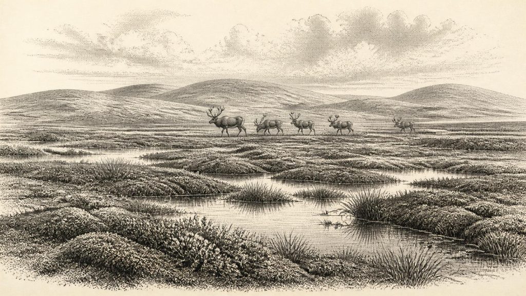
Around 33,500 years before present, the landmass later called Ireland experienced a volatile Late Pleistocene climate, rather than a dateable historical year. Derryvree, County Fermanagh, preserves freshwater silts between glacial tills, indicating cold, open tundra-like wetlands with mosses, sedges, herbs and seasonal liquid water. Other sites, including Crag Cave, reveal intermittent milder phases amid severe conditions. Cave fauna indicates episodic presence of reindeer, mammoth, giant deer, predators and other cold-adapted animals. No secure evidence establishes resident people, society or settlement, although disputed marks on a reindeer bone may suggest human butchery. Later ice expansion reshaped landscapes and erased much evidence.
Dateline
The label 31,576 BCE cannot describe a year in Ireland in the ordinary historical sense. No people then used a calendar that can be correlated with ours, and neither archaeological deposits nor environmental records resolve events to a single year. The number is best treated as a modern point within a much broader Late Pleistocene time-window, approximately 33,500 calendar years before present. The relevant evidence is dated in calibrated ranges that may extend across centuries or millennia. What it can illuminate is an episode in the last Ice Age when parts of the landmass now called Ireland were cold, largely treeless and environmentally unstable, but not necessarily everywhere overwhelmed by ice.
A Time Between Glacial Advances
This was Marine Isotope Stage 3, a long and climatically volatile portion of the last glacial cycle. Ireland had no modern coast, state, population or fixed identity. Lower global sea levels exposed parts of the continental shelf, altered river mouths and changed the relationship between the future island and Britain. Yet low sea level did not automatically create a simple, continuous land bridge usable at all times: local ice, sea water, shifting shorelines and difficult terrain mattered. The geography available to animals—and, conceivably, to people—changed repeatedly.
The decisive event of Ireland’s last glaciation, the expansion of the British–Irish Ice Sheet to its greatest extent, lay ahead rather than precisely at this point. Modern reconstructions show that its maximum was regionally asynchronous, with major advances occurring later, broadly around 27,000 to 23,000 calibrated years before present in many Irish sectors. That later ice was extensive enough to reshape much of the island and its surrounding shelf. Around the nominal date considered here, the evidence instead points to a complicated pre-maximum world: ice had affected Ireland before, but some local environments remained ice-free long enough for freshwater sediments, plants and insects to accumulate.
This distinction is important. It would be wrong to picture the whole island as green and hospitable; it would be equally wrong to imagine a uniformly sealed, featureless ice cap. The surviving record shows a mosaic of cold-stage landscapes whose extent changed through time and differed from region to region. Much evidence has also been removed, mixed or buried by later glaciers. Survival of any undisturbed deposit is therefore exceptional rather than typical.
Derryvree Beneath the Drumlin
The key Irish locality for this broad interval is Derryvree, near Maguiresbridge in County Fermanagh. Road-cutting through a drumlin exposed fine freshwater sands and organic silts trapped between two thick till sheets. Till is sediment deposited directly by glacier ice; the sequence therefore records an earlier glacial episode, an intervening phase when water and organic material could accumulate, and a later advance that covered and preserved the deposit beneath the drumlin.
A conventional radiocarbon determination from Derryvree, Birm-166, was 30,500 radiocarbon years before present, with a substantial uncertainty. Calibration produces a much wider range of roughly 36,900–31,700 calibrated years before present. The modern label 31,576 BCE falls within that interval, but this must not be mistaken for a precise date for the wetland itself. The result is evidence that the deposit belongs somewhere within a long cold-stage span; it does not identify the weather, inhabitants or events of one particular year.
Still, the contents are eloquent. Plant and insect remains indicate open, northern vegetation associated with freshwater pools, mosses, sedges and herbs. Pollen and macrofossils do not reveal a forested Ireland. They indicate a landscape often characterised as tundra or muskeg: wet, moss-rich ground with shallow water, waterlogged margins and low vegetation. Dwarf shrubs may have found protected niches, but the wider setting was exposed, with a short growing season and hard winter conditions. The presence of freshwater tells us that at least locally there was seasonal thaw and liquid water. It does not mean a mild climate.
Nearby Fermanagh deposits add context without supplying year-by-year confirmation. At Greenagho, near Belcoo, organic material beneath till returned a radiocarbon age of about 32,460 BP, though specialists urge caution about what that legacy measurement can securely establish. Hollymount and Aghnadarragh preserve other inter-till sequences. Together these sites demonstrate that northern Ireland retained or regained ice-free terrestrial and wetland habitats during parts of the Midlandian glaciation. They do not demonstrate that every deposit formed simultaneously, nor that the same vegetation covered all Ireland.
Cold Water, Open Ground
Derryvree’s wetland was part of a North Atlantic climate system capable of abrupt shifts. Evidence from Crag Cave in County Kerry offers an independent, though differently dated, environmental archive. Calcite speleothems form only when liquid water percolates through caves. Uranium-thorium dates show that deposition in Crag Cave occurred episodically during Marine Isotope Stage 3, broadly coinciding with warmer Greenland interstadials. Their growth does not turn southwest Ireland into a temperate refuge; it instead confirms that brief ameliorations could interrupt severe cold, allowing water movement, soils and vegetation to revive.
The contrast between Derryvree’s cold freshwater deposits and Crag Cave’s intermittent calcite is a useful warning against simple narratives. A cave record and a wetland record respond to climate in different ways, and neither has annual resolution at 31,576 BCE. Taken together, they support an interpretation of climatic fluctuation: permafrost and frozen ground could dominate during harsher phases, while less severe episodes allowed pools, streams, organic soils and cave drip-water to persist or return. This variability shaped every opportunity for plants, animals and any human visitors.
Animals and a Fragmentary Faunal Record
Irish cave collections show that a surprisingly diverse large-mammal fauna reached Ireland during parts of Marine Isotope Stage 3. Castlepook Cave near Doneraile, County Cork is especially important. Reassessment using improved pretreatment and radiocarbon methods has pushed several specimens substantially older than earlier dates suggested. Its wider assemblage includes evidence for reindeer, woolly mammoth, spotted hyaena, brown bear, wolf, fox, hare, lemmings and giant deer. Such finds make clear that the Irish landmass was not biologically empty before the Last Glacial Maximum.
However, cave assemblages must be read cautiously. Bones collected in antiquarian excavations may have been disturbed, accumulated by carnivores, washed into crevices or derived from different periods. A species list for Castlepook is not a census of animals living together beside the Awbeg in 31,576 BCE. Nor can it prove migration routes, population sizes or the seasonal movements of a particular herd. The most responsible conclusion is narrower: cold-adapted and open-country mammals entered Ireland intermittently during the broader period, exploiting landscapes sufficiently productive to support them.
Predators, scavengers and herbivores imply ecological connections rather than a settled human economy. Reindeer and giant deer would have consumed available vegetation; hyaenas and wolves tracked animal populations and left their own marks on bones. Mammoths, where present, belong to a wider mammoth-steppe or tundra-associated fauna familiar across parts of Late Pleistocene Europe. Ireland’s caves provide scattered traces of that world, not a complete food web. Later ice and the early excavation history of many caves severely limit what can now be reconstructed.
The Human Question
There is no securely excavated dwelling, hearth, lithic assemblage, burial or human skeleton in Ireland dated to this interval. Accordingly, there is no defensible basis for describing a resident population, named group, social hierarchy, language, ritual practice or political order in 31,576 BCE. There were no known Irish polities, leaders, diplomatic relations, borders or wars. “Politics”, “conflict” and “religion” are not absent because people necessarily lacked them; they are absent from the surviving Irish evidence.
Castlepook nevertheless poses an important possibility. A reindeer femur fragment held from the cave collections has been reported as bearing deep marks potentially made during butchery with a stone tool, and it has been associated broadly with the Upper Palaeolithic. If that interpretation is eventually sustained through further taphonomic study and securely contextualised finds, it would indicate that people reached Ireland far earlier than the long-established terminal Pleistocene evidence from County Clare. It would not prove permanent settlement, a camp at the cave, or a continuous ancestral population.
For now, the distinction between evidence and interpretation is crucial. The bone is evidence for a reindeer and for marks requiring specialist assessment. The proposition that humans made those marks is significant but uncorroborated by an associated toolkit or undisturbed processing floor. At most, the wider environmental record permits the possibility that small, highly mobile Upper Palaeolithic groups could have entered an intermittently habitable Irish landscape, perhaps following game or moving through wider north-west European networks. It cannot tell us how often this happened, for how long, or whether any visitors survived locally through later climatic deterioration.
No Society to Invent
It is tempting to fill the silence with familiar Ice Age scenes: hunters around fires, hide tents, carved objects and exchange between bands. Comparable practices are well documented elsewhere in Upper Palaeolithic Europe, but they cannot responsibly be transferred wholesale to Ireland. No Irish material of this age securely identifies tools, homes, clothing, art, traded objects, teaching traditions or ceremonial places. Reindeer, bone, antler, hides and stone may have been useful resources to any visitors; Derryvree and Castlepook cannot demonstrate their actual use.
The economic history of this time is therefore ecological rather than commercial. Wetland plants, summer grazing, animal movement, shelter in karst and the availability of freshwater set the limits within which life might occur. There is no evidence for farming, metalworking, domesticated stock, long-distance trade or permanent villages. Regional change was driven above all by climate and ice-sheet dynamics: advancing glaciers could destroy habitats, rearrange drainage and erase archaeological traces; colder intervals could close routes that had briefly been open.
A Precarious Irish Landscape
What matters most about Ireland around this nominal date is not an invented event but the fragility of the record. Derryvree’s silts preserve a rare glimpse of sedge-fringed pools beneath later glacial deposits. Crag Cave records intervals when water could still circulate through a southwest Irish cave. Castlepook’s bones attest to animals moving through a cold, open landscape and perhaps to an unresolved human encounter. Together they show an Ireland at the edge of habitability, before the later expansion of ice transformed the terrain again.
Modern calendar-year precision is unavailable, but the wider archaeological and environmental evidence is meaningful. Around 31,576 BCE, the future island was not yet the settled, wooded Ireland of later prehistory. It was a changing Pleistocene environment: locally ice-free in places, cold and wet in others, rich enough at times for tundra vegetation and large mammals, and vulnerable to the advancing power of the British–Irish Ice Sheet. That is the historical reality the evidence can sustain.
Primary Sources
- A Middle Midlandian Freshwater Series at Derryvree, Maguiresbridge, County Fermanagh, Northern Ireland
- Early Midlandian–Middle Midlandian, Pleistocene, Northern Ireland
- Middle Midlandian Interstadial Deposits at Greenagho, Near Belcoo, County Fermanagh, Northern Ireland
- The Geological Heritage of County Leitrim
- Trimlines, Blockfields and the Vertical Extent of the Last Ice Sheet in Southern Ireland
- A Reconsideration of the Radiocarbon Dating of the Marine Isotope Stage 3 Fauna from Southern Ireland
- Episodic Speleothem Deposition Tracks the Terrestrial Impact of Millennial-Scale Last Glacial Climate Variability in SW Ireland
- Late Pleistocene Chronostratigraphy and Ice Sheet Limits, Southern Ireland
- Late Pleistocene Chronostratigraphy and Ice Sheet Limits, Southern Ireland
- Growth and Retreat of the Last British–Irish Ice Sheet, 31,000 to 15,000 Years Ago: the BRITICE-CHRONO Reconstruction
- Timing and Pace of Ice-Sheet Withdrawal Across the Marine–Terrestrial Transition West of Ireland During the Last Glaciation
- Exploring Controls of the Early and Stepped Deglaciation on the Western Margin of the British Irish Ice Sheet
- Deglaciation Chronology of the Donegal Ice Centre, North-West Ireland
- The Deglaciation of the Western Sector of the Irish Ice Sheet from the Inner Continental Shelf to its Terrestrial Margin
- New Data for the Last Glacial Maximum in Great Britain and Ireland
- The Last Glacial Maximum British–Irish Ice Sheet: a Reconstruction Using Digital Terrain Mapping
- The Last Eurasian Ice Sheets – a Chronological Database and Time-Slice Reconstruction, DATED-1
- The Irish Quaternary Fauna Project
- First Evidence of a Late Upper Palaeolithic Human Presence in Ireland
- New Insights on the Fauna of Ireland's Younger Dryas and Early Holocene from Alice & Gwendoline Cave