
The Derryvree Drumlin Section31620 BCE
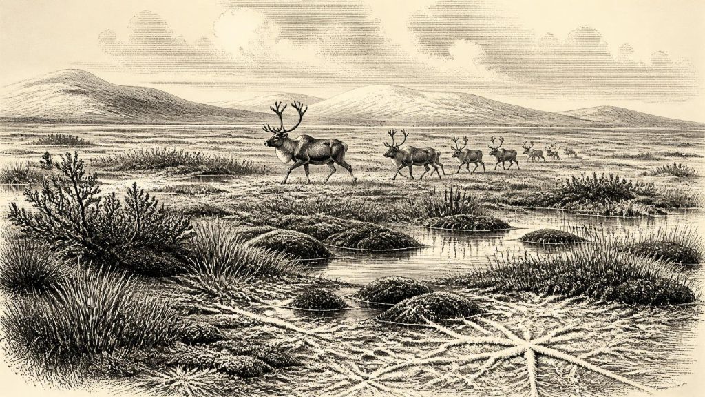
31,620 BCE is a modern label for an uncertain interval during Marine Isotope Stage 3, rather than a recorded Irish year. At Derryvree, Fermanagh, organic freshwater sediments between glacial tills indicate a locally ice-free, cold tundra wetland, later overridden by ice. Crag Cave calcite records climatic fluctuations, while lower sea levels altered surrounding routes. Castlepook Cave preserves reindeer, mammoth, giant deer, bear and hyaena remains, demonstrating changing cold-environment fauna, although mixed cave deposits limit precision. A cut-marked reindeer bone suggests possible Upper Palaeolithic visitors, but no secure settlement evidence exists. Ireland was variable, intermittently glaciated and perhaps visited by people.
Dateline
The label 31,620 BCE is a modern way of locating a point very deep in the past, not a year that anyone in Ireland recorded or could have recognised. It is approximately 33,570 years before AD 1950, the reference point used for calibrated radiocarbon ages. At that distance, archaeology cannot distinguish one calendar year from the next. The responsible history is therefore of a broad interval around this notional date: later Marine Isotope Stage 3, within the Midlandian cold stage of Ireland’s Pleistocene. Its evidence is indirect and uneven—buried wetland sediments, cave bones, pollen and plant remains, insects, cave calcite, ice-sheet landforms and radiocarbon measurements—not documents, monuments or settlements.
That distinction matters. A calibrated range is not an event date. Radiocarbon ages require conversion because atmospheric carbon-14 has varied through time, and the calibration curve itself incorporates uncertainty. At Derryvree, County Fermanagh, an organic freshwater layer produced a conventional determination of 30,500 radiocarbon years BP, with a large error margin; published calibration places it broadly about 36,900–31,700 calendar years BP. The modern year-label falls within that wide window, but it cannot identify a particular season, generation or occurrence at Derryvree.
A Wetland Beneath the Till
Derryvree, two kilometres north-east of Maguiresbridge, is the most revealing Irish environmental archive for this part of the last Ice Age. Road works in 1969 cut through a drumlin and exposed fine sands and organic silts trapped between two thick, distinct sheets of till—sediment laid down directly by or close to glacier ice. The layered sequence preserves an extraordinary proposition: after an earlier ice advance but before a later one, freshwater accumulated here long enough for plants and small animals to leave a record. The younger glacier then sealed that record inside the drumlin.
The original investigators identified a flora and fauna of full-glacial character. Plant remains, pollen and insect evidence indicate an open tundra or tundra-like landscape, with wet, organic ground and pools rather than woodland. The phrase should not summon an unbroken plain of snow. It describes a sparse, cold-adapted mosaic: sedges, mosses, herbs and low shrubs around waterlogged patches, with exposed mineral ground and seasonally severe conditions. The insect assemblage has been interpreted as compatible with muskeg—a mossy, plant-rich wetland with open pools. This was a living landscape, but a demanding one, shaped by frozen ground, meltwater and a very short productive season.
Derryvree is evidence for local ice-free conditions while those freshwater beds formed; it is not a map of all Ireland. Nor does the lower till prove that every part of the island had been ice-covered at the same moment. Ice sheets were dynamic, with centres, margins and corridors responding differently to topography and North Atlantic climate. The later till does, however, show that the Derryvree wetland belonged to an interrupted history of glaciation. Its landscape was eventually overridden or enveloped by ice and reshaped into the drumlin visible today.
Before the Greatest Expansion
At around 33,570 calibrated years BP, the climactic maximum of the last British–Irish Ice Sheet was still ahead, although the route towards it was neither simple nor uniform. Modern reconstructions place major growth and advance during the succeeding millennia, while offshore and onshore evidence shows that different sectors could advance, retreat, stagnate or reorganise at different times. Work on the western margin indicates shelf-edge glaciation by about 27,000 years ago; research in southern Ireland demonstrates that much terrain once assigned to much older glaciations was also affected during the last glacial maximum.
For this earlier period, it is safest to envisage regional change rather than an island either wholly ice-bound or wholly open. The Derryvree sediments show that a cold freshwater environment existed in Fermanagh within the dated span. Crag Cave in County Kerry supplies a different kind of clue: uranium-series dating of its calcite formations shows episodic water flow in south-west Ireland through much of Marine Isotope Stage 3. Because calcite growth in this shallow cave required liquid water and conditions broadly above the freezing threshold, it confirms that the last glacial climate on Ireland’s Atlantic edge fluctuated substantially on millennial scales. It does not tell us that Derryvree and Crag Cave experienced identical weather in the same year, but it cautions against treating the Ice Age as climatically static.
Coastlines, too, were unlike those of modern Ireland. Global sea level was lower during the glacial period, exposing portions of the surrounding continental shelf, while ice, crustal movement and sea-level change continually altered routes across the Irish Sea region. Whether a usable land connection existed at any particular moment is a specialised and contested palaeogeographical question, not something that can be read from a modern map. For animals and any people, access depended upon shifting combinations of sea, ice, exposed shelf and local terrain.
Castlepook and the Animal Record
Far to the south, Castlepook Cave near Doneraile in north County Cork preserves the most important faunal archive relevant to Ireland around this broad horizon. Antiquarian excavations in the early twentieth century recovered a large, but imperfectly documented, collection from its chambers. Later work by the Irish Quaternary Fauna Project used accelerator radiocarbon dating to establish that mammals had reached Ireland during the late Pleistocene. More recent redating, using improved pretreatment of bone collagen, found that several Castlepook results were thousands of radiocarbon years older than earlier determinations suggested.
The cave’s pre-last-glacial-maximum fauna includes reindeer, woolly mammoth, giant deer, brown bear and spotted hyaena, alongside smaller cold-adapted species. These names offer a powerful corrective to the familiar green and wooded image of Ireland. They demonstrate that, during parts of Marine Isotope Stage 3, large mammals characteristic of open, cold European environments reached the island or its changing margins. Yet the assemblage must be handled carefully. A cave is not a census of a single valley on a single day. Carnivores could drag prey or scavenged remains underground; bones from different episodes may be mixed; and many early excavations removed sediment before modern stratigraphic recording existed. The list demonstrates regional faunal possibilities across a long span, not a guaranteed simultaneous community in 31,620 BCE.
Spotted hyaena is especially significant because a denning or scavenging carnivore helps explain why caves can contain concentrations of bones. Castlepook therefore records ecological relationships as well as species: large herbivores moving through open country, predators and scavengers exploiting carcasses, and caves acting as traps, shelters or bone accumulators. Mammoth remains should not be turned into claims for a settled ‘mammoth-hunting’ society in Ireland. They are evidence that mammoths occurred in the wider faunal history of the site, not proof of a local human hunting economy.
The Human Question
A reindeer femur from Castlepook has made this period newly important for Irish archaeology. Its incision has been interpreted as a cut mark made by a sharp stone tool, consistent with butchery. The bone has been presented as dating to about 33,000 years ago, and the possibility is consequently that Upper Palaeolithic people briefly visited or hunted in Ireland during a relatively favourable interval of the last Ice Age. If that interpretation is sustained, it would greatly extend the evidence for human activity on the island.
But it remains a limited inference, not the foundation for a detailed social history. No securely associated hearth, stone-tool assemblage, dwelling floor, burial, art, food-preparation area or repeatedly occupied camp of this age has been demonstrated in Ireland. The reindeer bone was recovered from a cave archive shaped by early excavation and animal activity; the date of the bone cannot by itself date the cutting episode to a modern calendar year. It is therefore not responsible to name a group, assign an Aurignacian or Gravettian identity, reconstruct a household, or describe ritual from Irish evidence alone. Current excavations at Castlepook seek precisely the contextual evidence—charcoal, lithics, further modified bone and stratified deposits—that could test the case.
What Cannot Be Written
There were no recoverable political institutions, rulers, treaties, wars, diplomatic contacts, markets, religious sites or systems of learning in the evidence for Ireland at this point. That is not a judgement on the capacities of possible human visitors; it is a statement about the record. Mobile hunter-gatherers elsewhere in Upper Palaeolithic Europe possessed sophisticated knowledge, social ties and technologies, but comparison cannot fill Irish gaps with imagined camps, trade routes or beliefs. The only defensible economic observation is ecological: any short-lived human presence suggested at Castlepook would have depended on the movement and processing of wild resources, particularly large animals, in a cold and unstable landscape.
The absence of settlements is also partly a product of preservation. Later ice eroded and reworked extensive surfaces, while rising seas changed or submerged parts of the surrounding shelf. Portable tools and brief open-air camps are intrinsically difficult to find; caves and sediments sealed beneath till are exceptional survivors. Consequently, silence is not proof that no person ever crossed this landscape. It is proof that the evidence presently available cannot establish continuous occupation, population size or everyday practice.
An Archive of Intervals
Ireland around the modern label 31,620 BCE is best understood as an archive of intervals rather than an annalistic year. Derryvree offers a cold wetland enclosed between glacial episodes; Castlepook reveals a changing fauna of reindeer, mammoth, deer, bears and hyaenas; Crag Cave records climatic pulses through the survival of calcite; and a single altered reindeer bone raises, without settling, the prospect of very early people. Together they show that Ireland was neither timelessly frozen nor securely peopled. It was a variable north-western landscape in which water, frost, ice, animals and perhaps small mobile human parties repeatedly altered the possibilities of life.
Primary Sources
- A Middle Midlandian Freshwater Series at Derryvree, Maguiresbridge, County Fermanagh, Northern Ireland
- A Reconsideration of the Radiocarbon Dating of the Marine Isotope Stage 3 Fauna from Southern Ireland
- The Irish Quaternary Fauna Project
- Trimlines, Blockfields and the Vertical Extent of the Last Ice Sheet in Southern Ireland
- Late Pleistocene Chronostratigraphy and Ice Sheet Limits, Southern Ireland
- Radiocarbon Constraints on the Age of the Maximum Advance of the British-Irish Ice Sheet in the Celtic Sea
- Growth and Retreat of the Last British–Irish Ice Sheet, 31,000 to 15,000 Years Ago: the BRITICE-CHRONO Reconstruction
- BRITICE-CHRONO Maps and GIS Data of the Last British-Irish Ice Sheet 31 to 15 ka
- Exploring Controls of the Early and Stepped Deglaciation on the Western Margin of the British Irish Ice Sheet
- Episodic Speleothem Deposition Tracks the Terrestrial Impact of Millennial-Scale Last Glacial Climate Variability in SW Ireland
- The IntCal20 Northern Hemisphere Radiocarbon Age Calibration Curve (0–55 cal kBP)
- Deglaciation, Earth Crustal Behaviour and Sea-Level Changes in the Determination of Insularity: A Perspective from Ireland
- The Problem of a Late Quaternary Landbridge Between Britain and Ireland
- Figure 6.—The Subdivision of the Quaternary Period in Ireland
- Occurrence of Mammalia Relicts at Site Castlepook Cave
- Castlepook Cave, Castlepook South, Cork, 2022:564
- Archaeology Research Excavation Grant 2022: Final Report
- Heritage Artefacts of County Cork
- Irish Caves Database: Mammoth Cave
- New Insights on the Fauna of Ireland’s Younger Dryas and Early Holocene from Alice & Gwendoline Cave
- A Critical Review and Re-Investigation of the Pleistocene Deposits Between Cranfield Point and Kilkeel, Northern Ireland