
Cork’s Reindeer Threshold31592 BCE
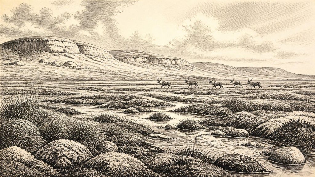
Around 31,592 BCE, Ireland lay within the climatically unstable Late Pleistocene, before maximum glaciation, when some areas remained ice-free. Subsequent ice sheets destroyed much evidence. Derryvree in Fermanagh preserves a tundra-like freshwater wetland, demonstrating productive open habitats. Castlepook Cave in Cork produced mammoth, reindeer, horse, giant deer and carnivore remains, showing that large animals reached Ireland during favourable intervals. A marked reindeer femur, possibly cut by a stone tool, suggests Upper Palaeolithic visitors, but cannot prove permanent settlement or continuous occupation. No contemporary Irish evidence identifies society, culture, politics or daily life; human presence remains tentative amid later encroaching glaciation.
Dateline
The label 31,592 BCE is a modern chronological convenience, not a year that anyone in Ireland could have known, named or recorded. At this depth of time, archaeology cannot identify events to a particular calendar year. In the conventional before-present system, calculated from 1950, it lies broadly around 33,500 calibrated years ago. That places it in the Late Pleistocene, within Marine Isotope Stage 3, a climatically unstable part of the last Ice Age. The responsible history of Ireland at this point is therefore not a narrative of named people or annual events, but a reconstruction from buried sediments, animal bones, cave deposits, glacial landforms and radiocarbon dates with substantial ranges of uncertainty.
An Island in an Unstable Ice Age
Ireland was not yet at the maximum extent of the last British–Irish Ice Sheet. Research on the timing of glaciation indicates that sizeable areas were still ice-free until roughly 34,000 years ago, while the great expansion that carried ice towards its later offshore limits came afterwards, principally between about 27,000 and 24,000 calibrated years before present in different sectors. Around 31,592 BCE, then, the island belonged to a changing cold-stage world rather than to a single, fixed landscape of universal ice.
That distinction matters. The later ice sheet repeatedly eroded, buried and rearranged older ground surfaces. Any light-built shelter, hearth, footprint, butchered carcass left in the open, or scatter of stone tools could easily have been destroyed or carried away. Survival depends on unusual circumstances: a cave chamber protected by rock, organic mud sealed beneath glacial deposits, or sediment trapped in a hollow. Ireland’s evidence is sparse not simply because people or animals may have been scarce, but because much of the physical record was vulnerable to subsequent glaciation.
Climate was also subject to abrupt North Atlantic shifts, familiar from Greenland ice-core records but not precisely transferable into an Irish seasonal history. Cold, wind and a short growing season are well supported. It is not possible, however, to state the exact temperature, snowfall, coastline, or vegetation pattern for the numbered year itself. Nor can deposits from widely separated parts of the island be treated as if they recorded one simultaneous Irish landscape.
Derryvree’s Buried Wetland
The clearest environmental glimpse relevant to this broad period comes from Derryvree, near Maguiresbridge in County Fermanagh. Road works in 1969 exposed freshwater silts and fine sands sandwiched between two thick tills in a drumlin. The deposit was formed during an earlier ice-free interval and then sealed beneath renewed glacial deposits. Its conventional radiocarbon determination of 30,500 ± 1,170/1,030 radiocarbon years before present calibrates broadly, rather than pinpointing an individual date; published conversions place it approximately within 36,900–31,700 calibrated years before present.
The Derryvree evidence is environmental, not archaeological evidence of a settlement. Pollen, plant macrofossils, mosses and insects indicate open, largely treeless vegetation. Sedges and other hardy plants grew on wet ground, beside shallow freshwater and moss-rich surfaces; dwarf shrubs and tundra plants occupied better-drained patches. The landscape has been compared with a cold muskeg or tundra wetland: not a uniform plain, but a mosaic of sedgy pools, damp hollows, frost-affected ground and open herbaceous cover.
This was emphatically not the later Irish countryside of woods, hedges, fields and pasture. Trees were at best very limited in the local record. The organic sediments nevertheless show that ice-free Ireland could support productive niches in which plants, insects and animals persisted through favourable phases of the Ice Age. Derryvree is especially valuable because it preserves details normally erased elsewhere. It cannot tell us what occurred in County Cork in the same generation, nor whether people ever visited the Fermanagh wetland.
Castlepook and the Faunal Record
North County Cork supplies the principal evidence for larger animals. Castlepook Cave, also called Mammoth Cave, near Doneraile yielded an important collection during excavations in the early twentieth century. The National Museum of Ireland describes it as the country’s most important site for mammal remains of the last cold stage. Its collections include bones of woolly mammoth, reindeer, horse, giant deer, brown bear, wolf and spotted hyaena. Radiocarbon work undertaken by the Irish Quaternary Fauna Project demonstrated that mammals reached Ireland during a long interval from at least about 45,000 to 20,000 years ago, rather than appearing as one single community at one single date.
For the period surrounding 31,592 BCE, the presence of reindeer and large carnivores is particularly revealing. Reindeer are compatible with extensive open country and seasonal movement through cold environments. Spotted hyaena, meanwhile, points to an ecological network that included substantial prey animals and carnivores capable of transporting or accumulating bones in caves. A cave bone assemblage should not be mistaken for a living herd photographed in one moment: animals may have died years or millennia apart, and hyaenas, wolves, water, roof-fall and early excavation practices all affected what survived.
Castlepook’s fauna nevertheless changes the scale on which Ireland must be imagined. The island was not an empty block of ice throughout the whole late Ice Age. At intervals before the Last Glacial Maximum, it formed part of a wider north-west European zone through which sizeable mammals moved. Exactly how animals reached it remains difficult. Lower sea levels changed the geography of the Irish Sea, but a simple, continuous land bridge should not be assumed. The existence, route and timing of possible connections remain debated, and passages may have involved complex combinations of exposed ground, water, islands and ice margins.
The Reindeer Femur Question
A single Castlepook reindeer femur has made this era important to Irish human history. The specimen has been reported as dating to about 33,000 years ago and bears a deep linear mark interpreted by zooarchaeologist Ruth Carden as damage made on fresh bone with a sharp stone implement during carcass processing. If that interpretation is upheld, it would indicate that a person handled a reindeer in Ireland during the Upper Palaeolithic, vastly earlier than the previously secure evidence for human activity on the island.
Its importance demands caution. The bone is not a settlement site, a tool assemblage or a human burial. It does not establish whether people killed the animal, found it dead, removed meat, cut hide or sinew, extracted marrow, or processed it some distance from the cave before carnivores brought the remains inside. Nor does it identify the number, origin, language, culture or duration of any visitors. Castlepook’s earliest excavations took place before modern standards of stratigraphic recording, and the mixed histories of cave deposits make associations difficult to reconstruct. A 2022 investigation located surviving deposits but found no cultural artefacts.
For that reason, the most defensible conclusion is deliberately narrow. Ireland may have been visited by Upper Palaeolithic foragers around this broad phase of the Late Pleistocene; the modified reindeer bone is potentially powerful evidence for that proposition. It is not proof of a permanent population, a named hunting band, or continuous occupation. Future excavations, direct dating and microscopic analysis may refine the question, but cannot turn a single marked bone into a complete social history.
Society Beyond Recovery
If humans were present, their likely subsistence would have depended heavily on mobile wild resources, especially large mammals, rather than farming. That is an inference from the ecology of the period and from Upper Palaeolithic practice elsewhere in north-west Europe, not direct evidence for an Irish hunting camp. No securely dated Irish houses, hearths, knapping floors, weapons, clothing, ornaments, burials or art belong to about 31,592 BCE. Everyday life can therefore be approached only through what survival in a cold, open landscape would have required: knowledge of animal movement, weather, terrain, fire and seasonal resources.
There is no evidence from Ireland at this date for political institutions, territories, rulers, diplomacy, organised warfare, trade systems or formal economic exchange. Animal movement across changing landscapes was not trade, and the presence of an incised bone is not evidence of conflict. Equally, there is no basis for reconstructing religion, ritual, language, music, stories or systems of learning. People elsewhere in Europe certainly possessed rich cultural lives during the Upper Palaeolithic, but it would be irresponsible to assign particular beliefs or artistic traditions to Ireland without Irish evidence.
Regional Change and Historical Scale
The contrast between Derryvree and Castlepook is the key to this date. Fermanagh preserves an inter-till freshwater environment, while Cork preserves cave fauna and one consequential possible trace of human action. Together, they show that parts of Ireland supported life during an ice-free or partly ice-free interval before later glacial expansion. They do not provide a map of every valley, coast and upland, and they do not demonstrate that one human community ranged between the two places.
The largest development was environmental rather than political: Ireland was moving into the severe conditions that would culminate in the Last Glacial Maximum. Faunal corridors and habitable patches that had existed during earlier favourable phases were increasingly constrained. The evidence is fragmentary, but its lesson is substantial. Around this modernly numbered year, Ireland was a cold, dynamic and intermittently habitable landscape, where reindeer, mammoth and hyaena could leave durable traces, while any human presence remains a compelling but still limited archaeological question.
Primary Sources
- A Middle Midlandian Freshwater Series at Derryvree, Maguiresbridge, County Fermanagh, Northern Ireland
- Trimlines, Blockfields and the Vertical Extent of the Last Ice Sheet in Southern Ireland
- Trimlines, Blockfields and the Vertical Extent of the Last Ice Sheet in Southern Ireland
- Maximum Extent and Dynamic Behaviour of the Last British–Irish Ice Sheet West of Ireland
- The Irish Quaternary Fauna Project
- Spotted Hyena Skull
- Heritage Artefacts of County Cork
- Archaeological Heritage of County Cork
- 2022:564 – Castlepook Cave, Castlepook South, Cork
- New Insights on the Fauna of Ireland's Younger Dryas and Early Holocene from Alice & Gwendoline Cave
- First Evidence of a Late Upper Palaeolithic Human Presence in Ireland
- First Evidence of a Late Upper Palaeolithic Human Presence in Ireland
- The Archaeology of Caves in Ireland
- The Problem of a Late Quaternary Landbridge Between Britain and Ireland
- Deglaciation, Earth Crustal Behaviour and Sea-Level Changes in the Determination of Insularity: A Perspective from Ireland
- The IntCal20 Northern Hemisphere Radiocarbon Age Calibration Curve (0–55 cal kBP)
- Composition and Consequences of the IntCal20 Radiocarbon Calibration Curve
- The IntCal20 Approach to Radiocarbon Calibration Curve Construction: A New Methodology Using Bayesian Splines and Errors-in-Variables
- The Greenland Ice Core Chronology 2005, 15–42 ka. Part 1: Constructing the Time Scale
- Figure 6.— The Subdivision of the Quaternary Period in Ireland
- The Last Irish Ice Sheet: Extent and Chronology
- Early Deglaciation of the British-Irish Ice Sheet on the Atlantic Shelf Northwest of Ireland Driven by Glacioisostatic Depression and High Relative Sea Level
- Appendix 18.1: Palaeogeographical Investigation