

Maguirebridge’s Arctic Reedbed31533 BCE
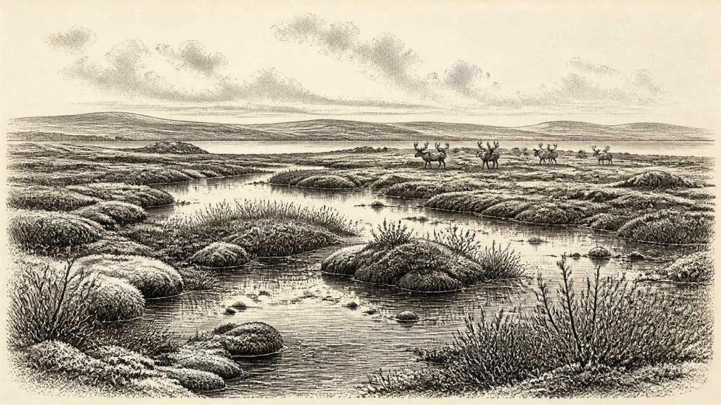
31,533 BCE is a notional date within a broad, uncertain Late Pleistocene range rather than an identifiable Irish event. At Derryvree near Maguiresbridge, Fermanagh, organic freshwater sediments between glacial tills indicate a temporary ice-free, treeless wetland of sedges, mosses, pools and periglacial ground. Castlepook Cave, Cork, preserves evidence of mammoth, reindeer, giant deer, predators and other cold-stage fauna. A possibly butchered reindeer bone suggests early human visits, but remains unconfirmed and cannot establish settlement or society. No evidence supports agriculture, villages, polities or continuous population. Climatic instability and approaching ice-sheet expansion shaped and later erased much of Ireland’s landscape record.
Dateline
31,533 BCE is a modern calendar label, not a date at which Irish evidence can identify a particular event. It falls roughly 33,500 calendar years before AD 1950, in the Late Pleistocene and within Marine Isotope Stage 3, a long and climatically unstable stretch of the last Ice Age. No Irish written record, calendar, named ruler or excavated settlement can be assigned to this notional year. Even scientific dates at this depth have wide uncertainties: radiocarbon ages must be calibrated, and calibration beyond 30,000 years ago remains necessarily broad. The responsible history of Ireland at this point is therefore not a diary of human affairs, but a reconstruction from buried sediments, fossil plants and insects, cave bones, geological landforms and changing ice.
A Date Within a Range
The most useful Irish chronological anchor is not an event dated to 31,533 BCE, but a buried freshwater sequence at Derryvree, near Maguiresbridge in County Fermanagh. Roadworks in 1969 cut through a drumlin and revealed fine sands and organic silts sandwiched between two substantial layers of till, sediment deposited by glacier ice. The sequence records a simple but important order: ice affected the locality; a non-glacial interval then permitted freshwater and wetland deposits to form; later ice buried and preserved them. Organic material from the deposit produced the conventional radiocarbon determination Birm-166, 30,500 +1,170/−1,030 radiocarbon years BP. Its modern calibrated equivalent is a broad span, conventionally placed at approximately 36,900–31,700 calendar years BP, or about 34,950–29,750 BCE.
That range encompasses 31,533 BCE, but it does not turn the numbered year into a precise moment in the sediment. The Derryvree beds cannot tell us whether a particular pool existed in one season, whether a reindeer crossed a specific marsh in one winter, or whether people were present during a particular twelve-month interval. They do, however, support a carefully bounded conclusion: during part of this wide Middle Midlandian interval, a locality in Fermanagh was free of overriding ice long enough for open freshwater and wetland conditions to develop.
Wet Ground Beneath Later Ice
Derryvree is especially valuable because most traces of landscapes of this age were later disturbed, removed or concealed by advancing ice. Its pollen, plant macrofossils, mosses and invertebrate remains indicate an open, treeless environment with wet ground, shallow water and periglacial conditions. Sedges and freshwater plants grew around pools and sluggish watercourses; mosses and other cold-adapted vegetation occupied damp margins. This was not the densely wooded, rain-green Ireland familiar from later prehistory or modern imagery. It was a low-productivity but varied patchwork of water, mineral sediment, peat-forming vegetation and exposed ground, shaped by cold, frost and seasonal change.
“Tundra” is a useful shorthand, provided it is not allowed to imply sameness. The Fermanagh deposit is local evidence from one basin, not a weather station for the whole island. Ireland’s western coasts, limestone lowlands, uplands, valleys and areas nearer expanding ice would not all have looked alike. Sheltered hollows could retain wetter vegetation, while exposed ground supported sparse cover and wind-blown sediment. Nor can the Derryvree evidence establish that all Ireland was ice-free at once. Its strength lies in showing that this particular district sustained a freshwater wetland during an interval between glacial episodes.
Caves and Cold-Stage Animals
Far to the south, Castlepook Cave near Doneraile in north Cork provides a different form of evidence. It is Ireland’s richest known cave archive for vertebrate life in the period before the Last Glacial Maximum. Excavations and later reassessment have recovered or identified remains of woolly mammoth, reindeer, giant deer, brown bear, wolf, hare and spotted hyaena, among other animals. The cave did not preserve a single undisturbed scene: water movement, carnivore activity, earlier excavation and the long accumulation of remains make its deposits complex. It should therefore not be treated as a neat census of animals living together in 31,533 BCE.
Nevertheless, its dated bones demonstrate that southern Ireland formed part of a wider north-west European world in which large herbivores and predators could at times occupy suitable terrain. The presence of mammoth and reindeer is consistent with open, cold-country habitats; hyaena remains are an important reminder that caves were often carnivore places before they became archaeological archives. Recent redating has also shown why older radiocarbon results require caution: improved pretreatment produced dates markedly older than several earlier determinations. The record is substantial, but its lesson is methodological as well as zoological—each bone needs a secure identification, context and date before it can bear historical weight.
The Human Question
One Castlepook reindeer femur has attracted particular attention because it has been reported as dating to about 33,000 years ago and as bearing damage interpreted by its examiner as stone-tool butchery. If that interpretation is sustained, it would be evidence that people reached Ireland far earlier than the formerly accepted terminal-Pleistocene record. Yet it is not evidence for a settled population, and it cannot be assigned specifically to 31,533 BCE. No securely dated house, hearth, lithic assemblage, grave, art panel or repeated occupation surface of comparable age has been excavated in Ireland. The cautious conclusion is that human presence in the broad pre-maximum glacial period is possible and potentially significant, but remains represented by exceptionally slight evidence.
That limitation determines what can honestly be said about society. There is no basis for naming an Irish people, tribe, language or ancestry at this date. If short-lived human visits did occur, their makers may have been highly mobile hunter-gatherers equipped to exploit animal resources in a difficult, seasonal landscape. That is an interpretation drawn from the wider Upper Palaeolithic world, not a demonstrated social portrait of Ireland. Neither farming nor permanent villages existed here on the available evidence. There is no evidence for agriculture, managed livestock, metalworking, long-distance exchange in objects, territorial institutions or a local population continuing uninterrupted into later Irish prehistory.
No Polities, No Diplomacy
Political affairs, warfare and diplomacy are consequently absent not because prehistoric people elsewhere lacked social relations, but because Ireland provides no evidence from which they can be reconstructed for this interval. There were no states, kingship traditions, legal texts or monuments in the Irish record. A reindeer bone with a possible tool mark, or a wetland containing sedge seeds, cannot reveal alliance, conflict or belief. Equally, there is no sound basis for assigning formal religion, ritual, learning or artistic traditions to Ireland around this date. The later mythology of Ireland, its medieval genealogies and its historic place-names belong to vastly later worlds and cannot be projected backwards across more than thirty millennia.
Economy, if humans were present at all, would have meant immediate subsistence: movement, observation, shelter, fuel, clothing and the use of animal materials. But the Irish evidence cannot show whether reindeer were hunted regularly, opportunistically scavenged, or merely encountered. The same restraint applies to travel. Lower global sea levels altered the surrounding shelf, but the precise configuration, accessibility and duration of possible routes between Ireland, Britain and continental Europe are debated. Animal occurrences show that dispersal happened at some points in the Pleistocene; they do not demonstrate a continuously walkable corridor, still less prove the route or frequency of human crossings.
Ice in the Future
The defining regional development was the approach of more extensive glaciation. Later in the last glacial cycle, the British–Irish Ice Sheet grew to cover Ireland and its continental shelf extensively, with maximum conditions conventionally placed around 27,000–23,000 calendar years BP. At 31,533 BCE, that later maximum still lay ahead, but the alternation at Derryvree—wetland deposits between tills—shows that ice advance and retreat already formed the essential context. Ice would subsequently erode landscapes, remould drainage, create and reshape drumlins, and destroy many traces of earlier habitation. The rarity of evidence is thus itself part of the history.
Ireland around this nominal year is best understood as a changing northern landscape rather than a nascent nation. In Fermanagh, buried freshwater sediments preserve a cold wetland world of sedges, mosses and open ground. In Cork, cave deposits preserve fragments of a larger animal community and a tantalising, unresolved indication of human activity. Together they show that the island was neither timelessly frozen nor securely populated. Its story was one of ecological opportunity constrained by climatic volatility, and of landscapes soon to be overwritten by ice.
Primary Sources
- A Middle Midlandian Freshwater Series at Derryvree, Maguiresbridge, County Fermanagh, Northern Ireland
- The IntCal20 Northern Hemisphere Radiocarbon Age Calibration Curve (0–55 cal kBP)
- Composition and Consequences of the IntCal20 Radiocarbon Calibration Curve
- The IntCal20 Approach to Radiocarbon Calibration Curve Construction: A New Methodology Using Bayesian Splines and Errors-in-Variables
- A Reconsideration of the Radiocarbon Dating of the Marine Isotope Stage 3 Fauna from Southern Ireland
- Castlepook Cave: Cork County Geological Site Report
- Castlepook Caves Project: Archaeology Research Excavation Grant 2022 Final Report
- 32564: Castlepook Cave, Castlepook, Cork
- Ireland's Palaeolithic Archaeology – Fleeting Footprints in a Frozen Land
- Heritage Artefacts of County Cork
- Deglaciation Chronology of the Donegal Ice Centre, North-west Ireland
- Growth and Retreat of the Last British–Irish Ice Sheet, 31,000 to 15,000 Years Ago: the BRITICE-CHRONO Reconstruction
- BRITICE Glacial Map, Version 2: a Map and GIS Database of Glacial Landforms of the Last British–Irish Ice Sheet
- New Age Constraints for the Maximum Extent of the Last British-Irish Ice Sheet (NW Sector)
- Dimensions and Chronology of the Last Ice Sheet in Western Ireland
- New Data for the Last Glacial Maximum in Great Britain and Ireland
- The Timing and Magnitude of the British–Irish Ice Sheet Between Marine Isotope Stages 5d and 2
- Ireland: Submerged Prehistoric Sites and Landscapes
- The Problem of a Late Quaternary Landbridge Between Britain and Ireland
- The Island of Ireland: Drowning the Myth of an Irish Land-Bridge?
- The Irish Quaternary Fauna Project
- Irish Pleistocene Biostratigraphy