

Derryvree’s Juniper Marsh31114 BCE
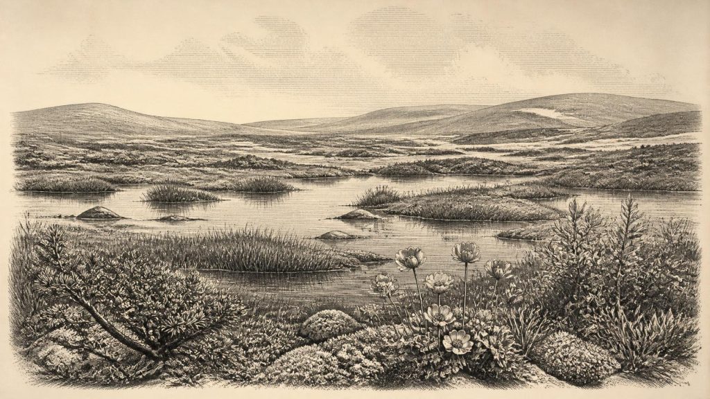
Around 31,114 BCE, Ireland cannot be described through a single recorded year, but Derryvree, County Fermanagh, preserves evidence of a cold, locally ice-free interval between glacial advances. Freshwater sediments, pollen, plants, mosses and insects indicate treeless tundra wetlands with juniper, sedges, dwarf willow and open water. This formed within the climatically unstable Marine Isotope Stage 3, as the British-Irish Ice Sheet expanded unevenly. Castlepook Cave’s fauna, including mammoth, reindeer and hyaena, shows wider ecological connections. A possibly cut-marked reindeer bone may indicate brief human activity, but no secure evidence supports permanent settlement, trade, institutions or local cultural traditions at all.
Dateline
“31,114 BCE” is a modern calendar label, not a year that anybody in Pleistocene Ireland could have named, recorded or experienced as a discrete historical date. In radiocarbon convention it lies roughly 33,063 calendar years before AD 1950, but that arithmetic does not turn it into an archaeologically visible year. The evidence is dated in ranges, often broad ones, and Ireland’s surviving record for this remote period is fragmentary. The responsible subject is therefore not an invented event in a particular year, but an Ice Age landscape whose conditions can be illuminated by deposits, animal bones and the developing chronology of the last British–Irish Ice Sheet.
A Date Within a Wide Range
The closest major Irish environmental archive is at Derryvree near Maguiresbridge, County Fermanagh. Road works in 1969 exposed a drumlin containing a remarkable sequence: glacial till below, freshwater silts and fine sands with organic material in the middle, and a later till above. Till is debris deposited directly by glacier ice. The sequence therefore securely establishes an order of events at that locality: ice had previously occupied it; a non-glacial interval then allowed a wetland or shallow freshwater body to form; and ice later returned and sealed the sediments beneath another layer of till.
Organic material from the Derryvree bed, laboratory code BIRM-166, produced a conventional radiocarbon age of 30,500 with an uncertainty of roughly 1,100 radiocarbon years. Radiocarbon years cannot simply be subtracted from 1950 and expressed as BCE dates, because atmospheric carbon-14 levels have varied. Calibration using the Northern Hemisphere curve instead produces a broad calendar interval; published discussions place Derryvree approximately within 36,900–31,700 calibrated years BP, or about 34,950–29,750 BCE. The nominal date 31,114 BCE falls within that broad span. It does not identify a particular season, plant, animal or phase of the wetland.
This limitation is central rather than disappointing. Derryvree is exceptionally valuable evidence for a cold, locally ice-free period in south Fermanagh during the later Pleistocene. It is not an annual diary, and it cannot be projected unchanged across the whole island. Its age, stratigraphic position and fossils nevertheless make it the best local guide to the kind of environment that could have existed in parts of Ireland around this point in deep time.
An Unstable Ice-Age Island
The wider setting was Marine Isotope Stage 3, a long phase of the last Ice Age marked by abrupt climatic shifts rather than one unbroken freeze. Ireland lay on the north-western edge of Europe, with sea levels far lower than today and the outlines of its coasts very different. It was not yet the wholly ice-covered landscape often imagined from the Last Glacial Maximum. The great British–Irish Ice Sheet was in a phase of growth and reorganisation. Recent syntheses treat the build-up of the ice sheet as beginning broadly after about 35–32 thousand years ago, while its maximum extent came later, principally around 27–21 thousand years ago.
That chronology should not be turned into a simple national map for 31,114 BCE. Ice sheets grow, thin and advance unevenly; evidence for their early stages is particularly difficult to preserve because later ice can erase it. Modelling and geological reconstruction suggest that small ice caps may have occupied uplands in north-west Ireland while other lowland areas remained ice-free or experienced periglacial conditions. Derryvree’s two tills and intervening freshwater deposits fit this larger pattern of oscillation: an environment could be glaciated, become available for water and vegetation, and then be overwhelmed again.
For people standing in such a landscape, the most conspicuous political force was not a state or a chiefdom but climate. There is no evidence for rulers, territories, diplomacy, warfare, law or institutions in Ireland at this date. Nor is there evidence for permanent villages. The terms of everyday survival were set by winter cold, seasonal thaw, water availability, animal movements and the changing reach of ice. That is an interpretation based on the physical record, not evidence that any known group occupied Derryvree itself.
Marsh, Tundra and Open Water
The Derryvree fossils make the intervening landscape more vivid. Pollen, plant macrofossils, mosses and insect remains point to open, treeless tundra or muskeg rather than forest. Grasses, sedges, herbs and juniper were important elements of the vegetation. Fossils include mountain-avens, dwarf willow, bogbean and alternate water-milfoil. These are not merely botanical curiosities: together they indicate a cold environment with wet ground, mossy margins and standing or slow-moving freshwater, in a landscape exposed to frost and seasonal change.
Bogbean and water-milfoil are especially useful reminders that “Ice Age” did not mean featureless snow. The Derryvree bed preserves aquatic and wetland life. Open pools could support submerged plants; sedges and mosses could grow at their edges; dwarf willow and mountain-avens belonged to a low, open vegetation cover. Insects add ecological detail, suggesting plant-rich wet ground rather than bare glacial debris. Such evidence supports the picture of a periglacial wetland mosaic: cold, exposed and probably windy, but biologically active during favourable parts of the year.
It does not support a precise reconstruction of temperature, snowfall or summer length for 31,114 BCE. Nor does it prove that the entire island looked alike. Southern limestone districts, uplands, river valleys and land nearer active ice would each have differed. Yet the Derryvree sequence decisively overturns any assumption that Ireland was uniformly buried under ice throughout the whole later Pleistocene. At least in this part of Fermanagh, freshwater life and tundra vegetation occupied an interval between glacial advances.
Animals at Castlepook
County Cork supplies a complementary, though differently complicated, archive. Castlepook Cave, also called Mammoth Cave, near Doneraile has produced one of Ireland’s richest collections of pre-Last Glacial Maximum animal remains. Improved radiocarbon pretreatment has shown that several earlier cave dates were too young, and that the cave’s Marine Isotope Stage 3 fauna is older than previously believed. Reindeer, woolly mammoth, giant deer, brown bear, spotted hyaena, wolf, fox, hare and lemmings belong to the broader Ice Age community documented there.
The assemblage demonstrates ecological connection with Britain and continental north-west Europe during periods when animal populations could reach Ireland across landscapes very unlike the modern island setting. It does not mean that every listed species lived together at one moment, nor that a cave represents a normal sample of the surrounding countryside. Caves collect bones through predation, scavenging, natural death, water movement and human excavation. Castlepook was also investigated extensively in the early twentieth century, which complicates the survival and context of its deposits.
Spotted hyaena is particularly revealing. Its presence indicates that a large carnivore could exploit the Irish landscape in this earlier part of the last glacial cycle, while mammoth, reindeer and giant deer evoke an open-country fauna. The relationship was ecological, not historical in the usual sense: predators, scavengers and herbivores followed food, shelter and seasonal opportunity. There is no evidence from Castlepook for organised hunting territories, herding, animal domestication or an economy based on settled production.
The Human Question
One Castlepook reindeer femur makes the question of human presence unusually important. County Cork heritage publications describe a deep mark on the bone as an incision made with a sharp stone tool during butchery, and place the object at about 31,000 BC. If that diagnosis is sustained, it may be Ireland’s earliest evidence that people handled and processed an animal. It would be compatible with a brief visit by mobile Upper Palaeolithic hunters or scavengers during the wider period represented by the bone.
The claim must remain carefully bounded. No securely associated stone-tool assemblage, hearth, dwelling, burial, occupation floor or large butchery deposit of comparable age has been recovered in Ireland. The bone was not excavated from a modern, sealed habitation layer, and the date of an animal’s death does not independently date the mark, reveal who made it, show whether the animal was hunted or found dead, or establish where the carcass was processed. Carnivore damage, sediment movement and surface alteration require specialist taphonomic assessment. A possible cut mark is significant evidence, but it is not proof of a permanent population.
Accordingly, society around this date is largely unknowable in specifically Irish terms. If people did enter Ireland, the most restrained inference is that they were highly mobile foragers able to use stone edges and animal resources in a cold environment. We cannot responsibly name them, estimate their numbers, reconstruct family life, or claim continuity with later Irish populations. There is no evidence for religious monuments, ritual sites, art, writing, formal learning or a distinctive local material culture. Absence of evidence is not proof that thought, belief or custom were absent; it means that none can presently be described from Irish finds of this age.
No Trade, No Polities, but Connected Landscapes
There is equally no evidence for trade in the later prehistoric sense: no imported goods, exchange networks, ports or established sea routes can be assigned to 31,114 BCE in Ireland. The important connections were environmental. Lower sea level and changing ice margins altered routes for animals and, potentially, people. Reindeer and other mammals indicate that Ireland was part of a wider north-west European ecological zone during favourable intervals. That biogeographical connection should not be confused with evidence for regular human travel or cultural exchange.
The most important development near 31,114 BCE was therefore the making of conditions rather than a recorded human event. In Fermanagh, freshwater sediment, plants and insects accumulated during an interval free of local ice. In Cork, caves preserved fragments of a much wider cold-stage fauna, along with a tantalising possible trace of human carcass processing. Later glacier advances would cover, disturb or remove much of this evidence. What survives is enough to show an Ireland of tundra wetlands, animal corridors and climatic uncertainty; it is not enough to populate that landscape with invented settlements, chiefs or ceremonies.
That restraint gives the period its real historical interest. Derryvree’s buried marsh and Castlepook’s bone assemblage are not empty preliminaries to later history. They record an older Ireland repeatedly transformed by ice, thaw and ecological movement, at a time when even the possibility of human presence remains a question being tested by new dating, excavation and careful re-examination of museum collections.
Primary Sources
- The IntCal20 Northern Hemisphere Radiocarbon Age Calibration Curve (0–55 cal kBP)
- A reconsideration of the radiocarbon dating of the Marine Isotope Stage 3 fauna from southern Ireland
- The Irish Quaternary Fauna Project
- Extent and timing of the Last Glacial Maximum (LGM) in Britain and Ireland: a review
- Behavioural tendencies of the last British–Irish Ice Sheet revealed by data–model comparison
- Pattern and timing of retreat of the last British-Irish Ice Sheet
- The deglaciation of the western sector of the Irish Ice Sheet from the inner continental shelf to its terrestrial margin
- Trimlines, blockfields and the vertical extent of the last ice sheet in southern Ireland
- Maximum extent and readvance dynamics of the Irish Sea Ice Stream and Irish Sea Glacier since the Last Glacial Maximum
- Irish Pleistocene biostratigraphy
- Palaeoecology
- BSBI: Menyanthes trifoliata
- BSBI: Salix herbacea
- BSBI: Dryas octopetala
- BSBI: Myriophyllum alterniflorum
- New insights on the fauna of Ireland's Younger Dryas and Early Holocene from Alice & Gwendoline Cave
- Heritage Artefacts of County Cork
- Timing, pace and controls on ice sheet retreat: an introduction to the BRITICE-CHRONO transect reconstructions of the British-Irish Ice Sheet
- Dimensions and chronology of the last ice sheet in Western Ireland
- A palaeo-glaciological reconstruction of the last Irish Ice Sheet
- Dynamic cycles, ice streams and their impact on the extent, chronology and deglaciation of the British-Irish Ice Sheet