Mammoth Cave’s Questioned Cut31113 BCE
31,113 BCE is a modern label for a Late Pleistocene interval, not a recorded Irish year. Derryvree, County Fermanagh, preserves freshwater sediments between tills, indicating an ice-free, cold, tundra-like wetland during fluctuating Midlandian conditions before major ice-sheet expansion. Castlepook Cave, County Cork, contains time-averaged remains of reindeer, mammoth, giant deer, hyaena and other cold-stage fauna. A cut-marked reindeer femur may indicate sharp-tool use by people, perhaps near this period, but cannot prove settlement or continuous occupation. Evidence supports intermittent habitability and environmental change, while political, cultural, religious and social history remains unrecoverable. No writing, farming, monuments, or human remains survive.
Dateline
31,113 BCE is a modern chronological label, not a year that could have been recognised in prehistoric Ireland. There was no Irish calendar, writing, state or historical chronicle from which an event could be dated so exactly. The responsible approach is therefore to locate this notional year within broader scientific ranges. It falls in the Late Pleistocene, during Marine Isotope Stage 3 and the Irish Midlandian cold stage, when climates fluctuated sharply and the British–Irish Ice Sheet was approaching, but had not yet reached, its later greatest extent.
Radiocarbon dates are conventionally measured before 1950 and must be calibrated against changing atmospheric carbon levels; they are not direct BCE dates. IntCal20 permits calibration back to 55,000 years before present, but it does not transform sediment, bone or pollen into an annual diary. Around the modern label 31,113 BCE, the best Irish evidence consists of environmental deposits, cave fauna and one potentially momentous but still limited bone modification. Together they show an island that could sustain life in severe cold, not a land for which politics or settled human society can be reconstructed.
A Freshwater Interval at Derryvree
The strongest local guide is Derryvree townland near Maguiresbridge, County Fermanagh. Road works in 1969 cut through a drumlin and exposed freshwater silts and fine sands sandwiched between two substantial tills: sediment left directly by separate ice advances. The position of the organic bed is fundamental evidence. It proves that, between episodes of glaciation, a basin held fresh water and accumulated sediment rather than lying beneath overriding ice.
The Derryvree organic material produced the conventional radiocarbon determination Birm-166, 30,500 ± 1,100/1,030 radiocarbon years BP. Subsequent regional Bayesian modelling has expressed this evidence at about 33.5 ± 1.2 thousand calibrated years BP. Neither formulation identifies 31,113 BCE as a discrete moment, but the latter range overlaps its broad horizon. It provides good evidence for ice-free ground in part of north-central Ireland during a cold interval before the major late expansion of the Irish Ice Sheet.
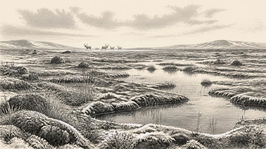
The deposit is also unusually informative about local living conditions. Its pollen was poorly preserved, which restricts certainty, but was chiefly herbaceous. Plant macrofossils and mosses, together with invertebrate evidence, indicate a cold, open, periglacial environment. Sedges and freshwater mosses grew at wet margins; other remains have been associated with plants suited to saturated or cold ground, including bogbean, water-milfoil, mountain-avens, dwarf willow and arctic clubmoss. This was not modern bogland transported unchanged into the past, nor a wooded Irish landscape. It was a variable tundra-like mosaic of shallow water, wet hollows, low vegetation and exposed mineral ground, shaped by short growing seasons and repeated freezing and thawing.
Derryvree must not be made to stand for every part of the island. It records one protected basin, and local conditions depended on relief, drainage, proximity to ice and climatic shifts. Yet related deposits at Greenagho near Belcoo, also in Fermanagh, reinforce the larger conclusion that ice cover was episodic rather than permanently uniform. Their significance lies partly in what later happened: advancing ice buried, reworked and reshaped much of Ireland’s older surface record. The survival of the Derryvree bed beneath till is therefore exceptional.
The Approach of the Ice Sheet
This was a cold stage, but 31,113 BCE should not simply be called the Last Glacial Maximum. Global studies place growth towards maximum ice extent broadly between 33,000 and 26,500 years ago, while reconstructions of the British–Irish Ice Sheet place its major build-up after about 35,000–32,000 years ago and its maximum extent later, broadly around 27,000–21,000 years ago. The exact sequence varied between sectors. Recent minimum reconstructions for around 31,000 years ago do not yet place ice over Ireland because the evidence is insufficient to define an island-wide ice cover at that moment.
Thus Ireland was a changing frontier, not a fixed white continent or a benign refuge. The Derryvree evidence shows that liquid freshwater and cold-adapted vegetation existed in Fermanagh during an ice-free interval. In the wider north-west European region, expanding ice, falling sea levels, changing coastlines and severe seasonal climates continually altered possible habitats and routes. Later shelf-edge advances demonstrate that ice ultimately extended far beyond modern Irish coasts. They do not prove that every Irish locality was simultaneously ice-covered around this particular modern BCE label.
Castlepook and the Human Question
County Cork supplies the most intriguing evidence relevant to people. Castlepook Cave, also known as Mammoth Cave, near Doneraile, was excavated principally between 1904 and 1908 under the auspices of the Royal Irish Academy’s cave-exploration work. Its collections, now associated with the National Museum of Ireland, include a remarkable assortment of Late Pleistocene animal remains. Reindeer, woolly mammoth, giant deer, brown bear, wolf, Arctic fox, lemmings and spotted hyaena demonstrate that, at different times, Ireland supported a far richer cold-stage fauna than its later island ecology might suggest.
Spotted hyaena is particularly important. Its bones, skull fragments and coprolites indicate that Castlepook was used within a carnivore landscape, perhaps as a den or place into which carcass remains were dragged. New radiocarbon work has revised the age of some southern Irish cave fauna substantially older than earlier determinations suggested. The cave is therefore a time-averaged faunal archive, not a single occupation layer: bones may have arrived through carnivore activity, natural death, water movement, frost disturbance and the complicated history of early excavation.
One reindeer femur has made Castlepook central to Ireland’s earliest human-history debate. Ruth Carden has interpreted a deep linear mark on it as damage made by a sharp stone tool during carcass processing. County Cork heritage material places the object approximately around 31,000 BCE. If that interpretation is confirmed, it would be the earliest presently claimed indication that a person handled an animal in Ireland, potentially placing a brief human visit in the broad chronological neighbourhood of this article.
Its limits are as important as its promise. The date concerns the animal bone, not an exactly known time of cutting, and the mark’s identification as anthropogenic is a specialist taphonomic judgement rather than a result supplied by radiocarbon alone. No securely associated stone-tool assemblage, hearth, dwelling surface, human burial or concentration of repeatedly butchered animals of this age has been recovered from Ireland. Nor was the femur excavated under modern stratigraphic conditions. The cautious conclusion is that the bone may record the use of a sharp lithic edge on a reindeer carcass; it does not establish a settlement, a continuous population or an event in the calendar year 31,113 BCE.
Animals, Resources and Movement
The Castlepook fauna nevertheless makes the landscape more tangible. Reindeer imply open feeding grounds, while mammoth, giant deer, wolves and hyaenas point to a substantial, if fluctuating, food web. Carnivores and scavengers could accumulate bones in caves, which explains both the value and the difficulty of the evidence. A cave bone assemblage reveals that animals reached an area; it does not necessarily show that they lived there together, in the same season, or within one stable ecosystem.
If people did reach Ireland during this interval, the most defensible economic interpretation is modest: mobile hunter-gatherers may have exploited animal resources, perhaps cutting meat, hide, sinew or marrow from a reindeer. It would be unwarranted to infer a named Upper Palaeolithic group, a permanent camp or routine trade. Mainland north-west Europe certainly contained human communities with sophisticated stone technologies and extensive social networks, but that continental evidence supplies context, not proof of equivalent activity in Ireland. Low sea levels altered the geography of the Irish Sea basin, but the exact route, season and scale of any human movement to the island remain unknown.
No Polities, No Recorded Beliefs
There is no evidence from Ireland at this date for political institutions, rulers, territorial diplomacy, warfare, formal law or diplomacy. There is likewise no Irish evidence for farming, herding, pottery, monuments, writing, schools, organised exchange networks or ritual structures. These are not omissions from an otherwise detailed national record: they are questions the surviving evidence cannot answer.
Religion and culture are equally beyond secure reconstruction. A possible butchered bone does not reveal language, kinship, beliefs, artistic practice or ceremony. Nor do animal fossils license stories of heroic hunts. What can responsibly be said is narrower and, in its way, more striking. Ireland was intermittently habitable for cold-adapted plants and large mammals before later ice expansion. At Castlepook, one marked reindeer femur may preserve a fleeting human action. At Derryvree, freshwater mud, mosses and sedges preserve the environmental setting more securely than any imagined episode.
What This Date Can Mean
The history of Ireland around 31,113 BCE is therefore a history of evidence rather than of recorded events. The directly observed facts are buried freshwater sediments in Fermanagh, fossils of cold-stage organisms, cave fauna in Cork and an unusually provocative mark on a reindeer bone. The broader reconstruction—open tundra-like ground, intermittent ice-free terrain, animal movement and the possible arrival of mobile hunters—is interpretation, supported to differing degrees by those facts and by regional comparison.
The main development was environmental instability on the eve of much more extensive glaciation. Derryvree preserves an ice-free wetland interval before a later ice advance; Castlepook preserves evidence that Ireland’s Pleistocene fauna included animals now unimaginable in the modern countryside. The questioned cut on a reindeer femur holds out the possibility that people briefly entered that world. It remains a question worth investigating, not a licence to invent Ireland’s first settlers, their politics or their calendar.
Primary Sources
- A Middle Midlandian Freshwater Series at Derryvree, Maguiresbridge, County Fermanagh, Northern Ireland
- A Reconsideration of the Radiocarbon Dating of the Marine Isotope Stage 3 Fauna from Southern Ireland
- Extent and Timing of the Last Glacial Maximum (LGM) in Britain and Ireland: A Review
- Growth and Retreat of the Last British–Irish Ice Sheet, 31,000 to 15,000 Years Ago: the BRITICE-CHRONO Reconstruction
- Exploring Controls of the Early and Stepped Deglaciation on the Western Margin of the British Irish Ice Sheet
- Trimlines, Blockfields and the Vertical Extent of the Last Ice Sheet in Southern Ireland
- Middle Midlandian Interstadial Deposits at Greenagho, Near Belcoo, County Fermanagh, Northern Ireland
- Palaeoecology: IQUA Field Guide 16
- The Subdivision of the Quaternary Period in Ireland
- Spotted Hyena Skull
- Heritage Artefacts of County Cork
- Archaeological Heritage of County Cork
- Archaeology Research Excavation Grant 2022
- Archaeology Research Excavation Grant Report 2023
- 2022:564 – Castlepook Cave, Castlepook South, Cork
- New Insights on the Fauna of Ireland’s Younger Dryas and Early Holocene from Alice & Gwendoline Cave
- The Irish Quaternary Fauna Project
- Ireland’s Fallow Deer: Their Historical, Archaeological and Biomolecular Records
- The IntCal20 Northern Hemisphere Radiocarbon Age Calibration Curve (0–55 cal kBP)
- The Last Glacial Maximum
- Early Deglaciation of the British-Irish Ice Sheet on the Atlantic Shelf Northwest of Ireland Driven by Glacioisostatic Depression and High Relative Sea Level
- Oscillating Retreat of the Last British-Irish Ice Sheet on the Continental Shelf Offshore Galway Bay, Western Ireland
- Marine Geophysical Evidence for Late Pleistocene Ice Sheet Extent and Recession off Northwest Ireland
- Timing and Pace of Ice-Sheet Withdrawal Across the Marine–Terrestrial Transition West of Ireland During the Last Glaciation
