
BIRM-166’s Radiocarbon Bracket30163 BCE
30,163 BCE is a nominal label rather than a recordable Irish year. Evidence from Derryvree, County Fermanagh, places freshwater sediments and remains between glacial tills during MIS 3, showing cold, treeless, waterlogged ground with hardy plants, insects and shallow water. Radiocarbon BIRM-166 provides a broad calibrated bracket, not a precise date. Castlepook Cave, County Cork, preserves Ice Age fauna, including mammoth, reindeer and predators, accumulated over time. A possibly tool-marked reindeer bone may indicate human activity, but no secure settlement exists. Ireland was environmentally variable, affected by shifting ice, low seas and climatic instability; its history remains landscape-based and uncertain.
Dateline
30,163 BCE is a modern chronological label, not a date that can be matched to a recorded Irish event. There was no Irish calendar, writing, named community or year-by-year historical record at this depth of time. In archaeological terms it falls in the Late Pleistocene, during Marine Isotope Stage 3 (MIS 3), within the wider Midlandian cold-stage sequence. Expressed in the convention used by Quaternary scientists, it is roughly 32,100 calendar years before AD 1950. That apparent precision is deceptive: neither radiocarbon dating nor environmental evidence can identify what happened in one particular calendar year.
The responsible approach is therefore to ask what evidence illuminates Ireland in the broad interval around this nominal date. The answer lies chiefly in buried sediments at Derryvree near Maguiresbridge, County Fermanagh; in cave bones from Castlepook, or Mammoth Cave, near Doneraile in north County Cork; and in wider reconstructions of the changing British–Irish Ice Sheet. Together they show an island on the Atlantic fringe of Ice Age Europe: climatically severe, environmentally varied and repeatedly reshaped by ice, water, frost and mobile animal populations.
Dating a Buried Landscape
Derryvree is the essential Irish site for this part of the Pleistocene. Roadworks in 1969 cut through a drumlin, exposing a remarkable sequence. A lower till – unsorted sediment deposited by glacier ice – was overlain by fine sands, freshwater silts and organic material, which were themselves capped by a second, thick till. The order of the deposits is firm even where absolute dates remain broad. Ice had affected the locality; an interval followed in which open water, wet ground and vegetation existed; then later glacier ice advanced across the area and sealed the earlier landscape.
An organic sample from the freshwater deposits, BIRM-166, produced a radiocarbon determination of 30,500 years BP, with a large quoted uncertainty of +1,170 and −1,030 radiocarbon years. “BP” means before AD 1950, not before the present day. Because atmospheric radiocarbon concentrations have varied, such results must be calibrated, and calibration at this age produces ranges rather than an exact historical date. Scholarly syntheses place the Derryvree horizon broadly in the middle part of MIS 3, approximately 35,900 ± 1,100 calibrated years BP in one treatment. It is therefore evidence for the same changing pre-Last Glacial Maximum world, rather than proof that its wetland existed in 30,163 BCE itself.
This distinction matters. Derryvree does not offer a snapshot of the whole island on a single day, and it should not be pressed into a national weather report. It does, however, demonstrate that at some point in this broad cold-stage interval, the Fermanagh locality was not beneath actively depositing glacier ice. Freshwater accumulated in a basin, plants grew, insects lived and organic matter survived long enough to be buried beneath a later advance. The site is a rare physical record of an Irish landscape between episodes of glaciation.
Shallow Water and Open Ground
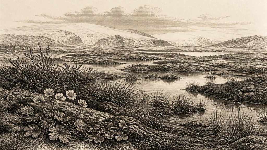
The Derryvree fossils give this lost landscape texture. Pollen preservation was limited, but plant macrofossils, mosses and insects point strongly towards cold, open and waterlogged conditions rather than woodland. Grasses and sedges occurred around wet margins. Remains attributed to dwarf willow, mountain-avens, lesser clubmoss, bogbean and alternate water-milfoil indicate a mosaic of shallow or slow-moving freshwater, saturated mossy ground and sparsely vegetated surfaces affected by frost.
The bogbean seed is especially memorable because it connects an otherwise remote Ice Age deposit to a recognisable wetland plant. Yet it must not make the landscape seem familiar. Its presence indicates suitable freshwater or saturated ground in one basin; it does not show a modern peat bog, nor a uniform vegetation cover across Ireland. Mountain-avens and dwarf willow, alongside the wider moss and insect evidence, support the interpretation of a treeless, tundra-like or muskeg-like environment. “Tundra-like” is a useful description, not a claim that Fermanagh was identical to any present-day Arctic region.
Life in such a setting would have been intensely seasonal. During the short productive season, pools and wet margins could support aquatic plants, sedges, insects and the animals that fed upon them. Winter brought prolonged cold, frozen ground and wind exposure. Freeze–thaw action affected drainage and soils; little or no tree cover protected the land. The environment was not lifeless, but neither was it a place of settled farming, managed pasture or dense forest. The landscape’s economy, in the ecological sense, depended upon climate, water and the brief annual growth of hardy plants.
An Island of Shifting Ice
At this stage the later Last Glacial Maximum had not yet reached its fullest extent. Large-scale reconstructions place the maximum volume of the British–Irish Ice Sheet much later, around 23,000 years BP, while the fullest Irish and Irish Sea advances occurred over a broader period in the later part of the last glaciation. But this does not mean that Ireland was simply ice-free in 30,163 BCE. The build-up, coalescence and movement of ice were regionally varied. Some areas may have retained exposed ground and freshwater basins while other sectors supported expanding ice or local glaciers.
The two tills at Derryvree are the warning against oversimplification. They show that the wetland belonged between glacial episodes, not outside the glacial world. North-west Ireland, the Irish Sea basin and the Atlantic shelf were connected to a wider British–Irish ice complex whose margins and flow patterns altered through time. Sea level was substantially lower than today, altering coastlines and exposing parts of the continental shelf, but the routes available between Ireland, Britain and continental Europe cannot be reconstructed confidently for one notional year. Ice, sea, weather and topography made access variable and difficult.
MIS 3 was also climatically unstable on a North Atlantic scale. Greenland ice-core records show abrupt alternations between colder stadials and relatively milder interstadials. Such changes offer an important context for Ireland, but they cannot securely be translated into a precise local temperature, season or event at Derryvree. The chronological uncertainty of Irish deposits is too large, and local landscapes responded differently according to altitude, exposure, drainage and proximity to ice.
Castlepook’s Animal Archive
For animal life, Castlepook Cave in County Cork is Ireland’s most important archive from the broad pre-maximum interval. Excavations begun in the early twentieth century recovered a rich collection of Pleistocene bones. The assemblage includes woolly mammoth, reindeer, giant deer, brown bear, wolf, fox, arctic fox, mountain hare, lemmings and spotted hyaena. Such animals indicate that parts of Ireland could support, or at least be reached by, a striking cold-stage fauna. Reindeer and lemmings belong readily in an open, northern environment; hyaenas and other carnivores remind us that caves could be dens and scavenging places as well as traps for bones.
However, Castlepook is not a single herd fossilised in one season. Its deposits accumulated across a long span, through carnivore activity, deaths, water movement, collapse, disturbance and antiquarian excavation. Radiocarbon determinations on mammoth and hyaena material have been associated with the middle part of the last glacial cycle, but individual bones need not be contemporaneous. The cave demonstrates a changing animal world, not a precisely dated food web for 30,163 BCE.
One reindeer femur has made Castlepook especially significant for Irish human history. Zooarchaeologist Ruth Carden identified a deep linear mark interpreted as having been made by a sharp stone tool while the bone was fresh. County Cork heritage material presents the specimen as Palaeolithic and broadly around 31,000 BC, and recent research projects have treated modified bones from the cave as an important reason to seek undisturbed deposits. If the mark is confirmed as a human butchery trace, it would indicate that a person or small group handled a reindeer carcass in Ireland during the Ice Age.
What Cannot Yet Be Claimed
The possible cut mark is consequential, but it is not evidence for a settled Irish population. No securely associated Palaeolithic stone-tool assemblage, hearth, dwelling floor, burial, artwork, human skeleton or stratified hunting camp of this age has been established in Ireland. The femur cannot tell us whether its modifier killed the animal or scavenged it, how many people were involved, where they came from, whether they crossed water or ice, or how long they stayed. Ongoing excavation at Castlepook is valuable precisely because it may clarify these questions without assuming their answers.
Accordingly, political affairs, diplomacy, warfare, religion, learning, trade and formal social institutions cannot responsibly be described for Ireland around this nominal year. There are no demonstrated rulers, peoples, alliances, shrines, markets or monuments. Nor is there evidence for agriculture, domestic animals, permanent settlement or exchange networks on the island. It would be misleading to import the better-known material culture and symbolic practices of Upper Palaeolithic groups elsewhere in Europe and call them Irish facts.
The broad European context nevertheless matters. Modern humans had occupied parts of Britain and continental Europe during the Upper Palaeolithic, and mobile hunter-gatherer groups elsewhere followed seasonal resources across changing landscapes. Ireland lay within that north-west European ecological world, but its own evidence remains unusually sparse. At most, Castlepook offers a tentative glimpse of human activity; Derryvree offers firmer evidence for habitat. The difference between those kinds of evidence must be preserved.
The Most Defensible Portrait
Around 30,163 BCE, then, Ireland cannot be given a conventional national history. The calendar year is too exact for the evidence, and the surviving record is not a chronicle of people. What can be said is both narrower and more compelling: in the wider interval, Ireland contained cold, open and locally wet landscapes between phases of glaciation; hardy plants grew beside freshwater in Fermanagh; large mammals and carnivores occupied or entered southern Ireland; and later ice buried, eroded and fragmented much of what might once have survived.
Derryvree’s bogbean seed is not a symbol of an invented prehistoric nation. It is a material witness to a short-lived wetland in a severe world. Alongside the Castlepook bones and the tills that frame the Fermanagh silts, it shows why Ireland’s deepest past must be written with care: not as a tale of imaginary tribes and events, but as a landscape history in which water, ice, plants, animals and uncertainty are the principal actors.
Primary Sources
- A Middle Midlandian Freshwater Series at Derryvree, Maguiresbridge, County Fermanagh, Northern Ireland
- Pleistocene Glaciations in Ireland
- Exploring Controls of the Early and Stepped Deglaciation on the Western Margin of the British–Irish Ice Sheet
- Growth and Retreat of the Last British–Irish Ice Sheet, 31,000 to 15,000 Years Ago: the BRITICE-CHRONO Reconstruction
- Deglaciation Chronology of the Donegal Ice Centre, North-West Ireland
- Trimlines, Blockfields and the Vertical Extent of the Last Ice Sheet in Southern Ireland
- Radiocarbon Constraints on the Age of the Maximum Advance of the British–Irish Ice Sheet in the Celtic Sea
- Late Pleistocene Chronostratigraphy and Ice Sheet Limits, Southern Ireland
- The Subdivision of the Quaternary Period in Ireland
- Palaeoecology
- Irish Pleistocene Biostratigraphy
- Pleistocene Vertebrates in the British Isles
- The Irish Quaternary Fauna Project
- Heritage Artefacts of County Cork
- Archaeology Research Excavation Grant 2022: Castlepook Cave Final Report
- 2022:564 – Castlepook Cave, Castlepook South, Cork
- Mammoth Cave
- Myriophyllum alterniflorum DC.
- Dryas octopetala L.
- IntCal History
- Mechanisms of Abrupt Climate Change of the Last Glacial Period
- Marine Isotope Stage 3 Sea Level Fluctuations: Data Synthesis and New Outlook
