
Derryvree, Castlepook, and Ice30706 BCE
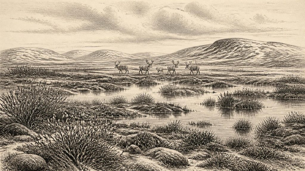
Circa 30,706 BCE, Ireland lay within the unstable cold conditions of Marine Isotope Stage 3, not a documented historical era. Derryvree, County Fermanagh, preserves organic freshwater sediments between glacial tills, dated broadly near this period. Plants, mosses, insects and sediments indicate an open, wet, tundra-like landscape with severe winters, rather than woodland or permanent refuge. Castlepook Cave, County Cork, contains varied Ice Age fauna, including mammoth, giant deer, reindeer, hyaena and Arctic fox, demonstrating ecological links with north-west Europe. A possibly butchered reindeer bone offers provisional evidence of human presence, but no settlement or established economy. They reveal ice-transformed landscapes.
Dateline
The label 30,706 BCE is a modern way of marking a point far beyond the reach of an Irish calendar, written record or year-by-year historical sequence. It must not be mistaken for the date of a recorded event. In archaeological practice, it falls roughly 32,655 years before the conventional radiocarbon “present” of AD 1950, within the Late Pleistocene and the climatically volatile interval generally called Marine Isotope Stage 3 (MIS 3). Modern calendar-year precision is not available. The responsible evidence consists of dated ranges, stratified sediments, fossil plants and insects, animal bones, cave deposits, and the landforms left by moving ice.
For Ireland, around this broad point in time, the strongest story is environmental rather than political. There are no identifiable peoples, rulers, territories, diplomatic relations, settlements, religious sites, artworks or institutions that can securely be assigned to the thirty-first millennium BCE. There is not even a demonstrated, continuously occupied human landscape. What can be recovered is a fragmentary but compelling picture of an island repeatedly reshaped by cold, ice, water and the movements of animals across the north-west European world.
A Number Within a Long Cold Phase
At this depth of time, the difference between a conventional radiocarbon age and a calibrated calendar range is crucial. Radiocarbon measurements are not ancient dates written down by contemporaries: they are laboratory estimates from once-living material, with statistical uncertainty and with a further need for calibration because atmospheric carbon-14 has varied. A famous Irish determination, BIRM-166, came from organic sediment at Derryvree near Maguiresbridge, County Fermanagh. It returned a conventional result of 30,500 radiocarbon years before present, with an uncertainty of more than a thousand years. Calibration turns that result into a broad span of possible calendar ages rather than a single point.
That range is useful because it places Derryvree close to the period represented by 30,706 BCE, but it cannot tell us what occurred in that nominal year, season or generation. Nor can it make Derryvree a miniature Ireland. The deposit preserves one local environmental interval between episodes of glaciation. Its value lies precisely in showing that the island’s climatic history was not a simple march from ice to thaw: cold, relatively ice-free ground and freshwater habitats could exist between advances, only to be buried beneath later glacial deposits.
Irish geologists traditionally call this part of the last glacial cycle the Middle Midlandian; internationally it belongs within MIS 3, broadly dated to about 57,000–29,000 years ago. Conditions altered sharply over centuries and millennia. The later Last Glacial Maximum, conventionally around 26,500–19,000 years ago, saw a much more extensive British–Irish Ice Sheet. Around 30,706 BCE Ireland was approaching that harsher phase, but the exact distribution, thickness and timing of ice varied by region and remain subjects of active research.
Derryvree’s Freshwater Evidence
In 1969 road works cut through a drumlin at Derryvree, about two kilometres north-east of Maguiresbridge. Beneath an upper till—sediment laid down directly by ice—and above an older till, investigators found silts, fine sands and organic-rich layers. This was not the residue of a familiar wooded bog. It recorded a cold freshwater and wet-ground setting: pools and shallow water, muddy margins, mosses, sedges and sparse vegetation in an open periglacial landscape.
The evidence is unusually detailed. Plant pollen, though poorly preserved, was overwhelmingly herbaceous. Macrofossils and pollen included freshwater and cold-tolerant plants, among them bogbean (Menyanthes trifoliata), dwarf willow (Salix herbacea) and alternate water-milfoil (Myriophyllum alterniflorum). Moss remains were especially important, because they showed that ground and water margins could support vegetation despite severe conditions. The assemblage does not justify imagining lush meadowland or forest. A few grains from trees such as pine and hazel may have been redeposited from older material; they are not sound evidence for woodland growing at Derryvree.
Insects strengthen this interpretation. Their ecological preferences indicate cold northern conditions and a mossy, waterlogged terrain with pools, plant debris and open ground. The landscape is often described as tundra or muskeg-like: not a perfect match for any modern place, but an intelligible shorthand for wet, low-growing vegetation in a frost-dominated climate. Winters were evidently severe, summers short, and exposed mineral ground probably widespread. The local waterbody was nevertheless biologically productive enough to trap plant remains and insects that now provide one of Ireland’s rare Late Pleistocene environmental archives.
This was regional change on a profound scale. The drumlin itself, and the two tills enclosing the organic beds, show that this wetland interval belonged between glacial episodes. Ice had previously crossed the area; later ice overran or sealed its deposits. Erosion by subsequent glaciers has destroyed much of the evidence that might once have existed elsewhere. Derryvree therefore documents survival of a landscape fragment, not a stable island-wide refuge or an uninterrupted era of habitable terrain.
Animals in the Southern Caves
County Cork offers a different category of evidence. Castlepook Cave, near Doneraile in the Awbeg Valley, is Ireland’s richest known cave repository for vertebrate remains from the time leading towards the Last Glacial Maximum. Excavations in the early twentieth century recovered more than 2,000 bones, although the age and depositional history of individual finds vary and some deposits were disturbed. Improved radiocarbon methods have shown that part of the southern Irish cave fauna is considerably older than earlier dates suggested.
Castlepook has yielded a striking Ice Age fauna: woolly mammoth, giant deer, reindeer, brown bear and spotted hyaena, as well as wolf, Arctic fox, hares and lemmings. The presence of these animals does not mean that every species lived together across all of Ireland at one time, nor that each occupied the cave. Cave deposits can accumulate over long periods; carnivores, flowing water, collapse and excavation history all affect what survives. Yet collectively the remains show that Ireland was connected ecologically to wider north-west European cold-stage environments, and that sizeable herbivores and formidable predators reached at least parts of the island during MIS 3.
Spotted hyaena is particularly revealing. Castlepook appears to have been used by hyaenas, which could drag prey or scavenged carcass parts into its passages. Thus the cave is not a hunting camp simply because bones occur there. Mammoth and reindeer speak of open, cold habitats with sufficient grazing; lemmings and Arctic fox reinforce the northern character of parts of the fauna. The actual terrain outside the cave would have varied with altitude, drainage, season and the position of ice, but it was radically unlike modern Ireland’s temperate, farmed and largely wooded countryside.
The Human Question
The possibility of people in Ireland during this broad period deserves care rather than either dismissal or sensational certainty. A reindeer femur from Castlepook has been reported as carrying a deep mark interpreted by zooarchaeologist Ruth Carden as damage from a stone implement during butchery. If that interpretation is sustained, it would be important evidence that one or more Upper Palaeolithic people processed a reindeer in Ireland around this general timescale.
But one modified bone is not a settlement. No securely associated hearth, stone-tool assemblage, dwelling surface, burial, human skeleton, repeated food-processing deposit or art of comparable age has been published from Castlepook. The object derives from an old cave collection rather than a modern, fully controlled excavation. Natural breakage, carnivore action, sediment movement and the collection’s complex history make context central. The finding should therefore be treated as a significant but provisional clue to a visit or brief activity, not proof of permanent population, a named community or an Irish hunting territory.
Accordingly, political affairs, warfare and diplomacy cannot be reconstructed. Neither can social organisation, kinship, language, ritual or learning. If people did reach the island, they may have travelled through a broader landscape in which sea levels were lower and connections between Ireland, Britain and continental Europe differed greatly from those of today. That is an inference from geography and Ice Age conditions, not evidence for a particular route, boat journey, alliance or migration at 30,706 BCE.
An Economy Without Farmers
There is no evidence for farming, herding, metalworking, pottery, trade networks or permanent villages in Ireland at this date. Had people been present, the plausible subsistence possibilities would have been hunting, scavenging, gathering and use of animal materials, but Ireland has not yielded a securely dated assemblage that allows those activities to be described as an established economy. Reindeer and other large mammals were resources in an ecological sense; they cannot automatically be made into proof of human exploitation.
Religion and culture are likewise beyond the evidence. No monument, burial rite, figurative art or ceremonial deposit can responsibly be assigned to this moment. The culture most clearly visible is the natural one: mosses colonising wet margins, sedges growing in shallow ground-water, insects occupying cold pools, and herds and predators moving through an exposed Ice Age terrain. Scientific knowledge itself is the bridge to this lost world, built from microscopic pollen, seeds, beetle fragments, bone collagen, stratigraphy and repeated reassessment of old collections.
Thus 30,706 BCE is best understood not as an Irish “year” with an event attached to it, but as a point inside a long and unstable environmental history. Derryvree preserves a brief freshwater tundra interval between tills; Castlepook preserves animal remains accumulated through changing conditions. Together they show that prehistoric Ireland was neither a timeless ice-covered void nor a documented human homeland. It was a shifting cold-world frontier whose surviving traces are precious precisely because later ice, water and time erased so much else.
Primary Sources
- A Middle Midlandian Freshwater Series at Derryvree, Maguiresbridge, County Fermanagh, Northern Ireland
- Palaeoecology: Irish Quaternary Association Field Guide
- Figure 6.—The Subdivision of the Quaternary Period in Ireland
- A Reconsideration of the Radiocarbon Dating of the Marine Isotope Stage 3 Fauna from Southern Ireland
- The Irish Quaternary Fauna Project
- Castlepook Cave: County Geological Site Report
- Prehistoric Details
- Ice Age Ireland
- Freshwater Organic Deposits and Stratified Sediments Between Early and Late Midlandian (Devensian) Till Sheets, at Aghnadarragh, County Antrim, Northern Ireland
- Trimlines, Blockfields and the Vertical Extent of the Last Ice Sheet in Southern Ireland
- Dimensions and Chronology of the Last Ice Sheet in Western Ireland
- Deglaciation Chronology of the Donegal Ice Centre, North-West Ireland
- The Timing and Magnitude of the British–Irish Ice Sheet Between Marine Isotope Stages 5d and 2
- Timing and Pace of Ice-Sheet Withdrawal Across the Marine–Terrestrial Transition West of Ireland During the Last Glaciation
- Radiocarbon Constraints on the Age of the Maximum Advance of the British-Irish Ice Sheet in the Celtic Sea
- Phylogeographic, Ancient DNA, Fossil and Morphometric Analyses Reveal Ancient and Modern Introductions of a Large Mammal: the Complex Case of Red Deer in Ireland
- New Insights on the Fauna of Ireland's Younger Dryas and Early Holocene from Alice & Gwendoline Cave
- Castlepook Cave, Castlepook South, Cork: 2022 Excavation Report
- Menyanthes trifoliata
- Salix herbacea
- Myriophyllum alterniflorum
- Heritage Artefacts of County Cork
- The Late Quaternary History of East-Central Ireland
- Pleistocene Vertebrates in the British Isles