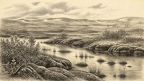
Derryvree’s Pre-LGM Wetland30576 BCE
Around 30,576 BCE, Ireland’s record is environmental rather than historical, with dates necessarily broad and uncertain. Derryvree, County Fermanagh, preserves freshwater sediments beneath later glacial till, indicating a cold, treeless, periglacial wetland of sedges, mosses, dwarf willow, aquatic plants and shallow pools. Ireland experienced shifting ice margins before the Last Glacial Maximum, leaving both glaciated and locally open terrain. Southern cave deposits, especially Castlepook, attest to mammoth, reindeer, giant deer, bears, hyaenas and other cold-climate fauna, although not contemporaneously. Human occupation remains unproven; a possibly butchered reindeer bone suggests only a tentative visit. Later glaciation destroyed or concealed much evidence.

Dateline
30,576 BCE is a modern calendar label, not a date that can be recovered from the Irish archaeological record with year-by-year precision. No written chronicle, named person, political event or exact seasonal occurrence can be assigned to this point in time. In radiocarbon terms, it lies roughly 32,525 years before AD 1950, during the later part of the Late Pleistocene and Marine Isotope Stage 3, a climatically unstable interval within the last Ice Age. The responsible history of Ireland at this depth is therefore environmental and archaeological: a reconstruction from buried sediments, animal bones, landforms and laboratory dates, all of which have broad margins of error.
A Date With Wide Margins
The closest important Irish environmental archive is at Derryvree, near Maguiresbridge in County Fermanagh. Roadworks in 1969 cut through a drumlin and exposed freshwater silts and fine sands between two separate layers of glacial till. Eric Colhoun, James Dickson, A. M. McCabe and Frederick Shotton published the sequence in 1972. Their radiocarbon determination, Birm-166, gave an age of 30,500 radiocarbon years before present, with a substantial uncertainty of +1,170 and −1,030 years. Later calibrations have placed the deposit broadly between about 36,900 and 31,700 calibrated years before present.
The requested date falls within that wide calibrated horizon, but that does not mean the Derryvree sediments were laid down in 30,576 BCE itself. A radiocarbon date is a probability range, not a historical timestamp; conventional radiocarbon years are not calendar years; and a sediment bed may have accumulated over many seasons or centuries. Moreover, an exposure beneath later till is an unusually fortunate survivor. It illuminates one locality at one broad phase of the Ice Age, not a complete map of the island at a single moment. Its value lies precisely in showing that cold-stage freshwater and vegetation could exist in northern Ireland before later ice covered and reshaped the terrain.
A Cold, Open Fermanagh
The evidence from Derryvree supports a treeless, tundra-like landscape rather than an unbroken wilderness of snow and glacier. Poorly preserved pollen was dominated by herbaceous plants. Plant macrofossils and mosses added much sharper detail, including sedges, mountain avens, dwarf willow, clubmosses, bogbean and aquatic water-milfoil. Bogbean and water-milfoil are particularly important: they point to wet ground and shallow freshwater. The likely scene was a mosaic of pools, sedge-fringed water, mossy ground, sparse low vegetation and exposed mineral soils.
This was a periglacial environment, shaped by prolonged cold and repeated freezing and thawing in the vicinity of ice, rather than necessarily a place buried beneath glacier ice at every point. Mountain avens and dwarf willow can tolerate cold, exposed ground; mosses and sedges exploit damp surfaces; aquatic plants reveal local water that remained available long enough for a wetland community to develop. The evidence does not support woodland, farming or a settled human landscape. A few scattered pollen grains of tree taxa are insufficient grounds for imagining forests. They may have travelled far, been redeposited, or simply be too sparse to represent substantial local tree cover.
Ice Sheets in Formation
Ireland’s glaciers were not static. The Last Glacial Maximum, conventionally placed around 26,000–19,000 years ago, still lay in the future, but the British–Irish Ice Sheet was developing through an uneven sequence of growth, advance, thinning and retreat. Recent reconstructions suggest that by about 31,000 years ago a substantial ice cap occupied parts of northern Ireland, while smaller ice fields and glaciers existed in several upland districts. Other evidence, including Derryvree’s freshwater deposits and dated deposits in western and southern Ireland, shows that ice-free or locally ice-free terrain also existed during parts of the wider interval.
That apparent contrast is not a contradiction. Ice sheets are regional systems with shifting margins, cold-based upland ice, outlet glaciers, meltwater corridors and ice-free pockets. Dating constraints before the maximum glaciation remain sparse and some older dates are difficult to assess against modern standards. Consequently, it is not responsible to declare all Ireland either ice-covered or ice-free in 30,576 BCE. The sounder conclusion is that the island belonged to a rapidly changing North Atlantic glacial world, in which the availability of habitable ground, freshwater and animal pasture could alter profoundly across relatively short geological timescales.
Animals and Cave Evidence
The cave deposits of southern Ireland show that this changing world supported a striking Pleistocene fauna. Castlepook Cave near Doneraile, County Cork, is the richest known Irish cave assemblage for such evidence. Its identified remains include woolly mammoth, reindeer, giant deer, brown bear, spotted hyaena, wolf, Arctic fox, lemmings and mountain hare. Re-dating programmes have shown that many southern Irish cave bones belong to Marine Isotope Stage 3, broadly between 45,000 and 20,000 years ago, although individual specimens and species need not have shared the cave at one time.
These bones establish animal presence and ecological possibility, not a single neatly assembled “Ice Age fauna” standing together in one valley. Cave deposits are complicated archives. Carnivores drag prey or carrion underground; floods and sediment movements may rearrange remains; earlier excavation methods often recorded context less closely than modern archaeology requires. Nonetheless, the combined fauna indicates that Ireland at intervals supported cold-adapted and open-country mammals, along with formidable predators and scavengers. Reindeer and mammoth imply substantial grazing landscapes somewhere within reach; hyaena remains suggest that carcasses and caves formed part of wider predatory territories.
The Human Question
Human presence around this date remains unproven. This point deserves emphasis because the temptation to convert an evocative animal bone into a national origin story is strong. No securely excavated Upper Palaeolithic hearth, stone-tool concentration, dwelling floor, burial, art panel or settlement surface has been established in Ireland for the thirty-second millennium BCE. The National Museum of Ireland continues to describe the evidence for Palaeolithic people in Ireland as unclear, while the most secure evidence for lasting colonisation belongs much later, in the Mesolithic.
A reindeer femur from Castlepook has nevertheless reopened the question. It was re-examined and directly dated to roughly 33,000 years ago; a deep mark has been interpreted by some researchers as having been made by a sharp stone tool during fresh-bone butchery. If that diagnosis and association are confirmed, it could indicate a brief Upper Palaeolithic human visit or episode of carcass processing in Ireland within the broad period relevant here. It would not prove permanent settlement, a named hunting expedition, a population size or continuous occupation. The bone’s age dates the animal’s death, while the old cave collection lacks the secure excavated associations that would turn one marked specimen into an indisputable camp.
Society Without a Settlement Record
Because there is no demonstrated community in Ireland at this date, there is no evidential basis for describing Irish households, leaders, kin groups, languages, religious beliefs, teaching traditions or social ranks. Nor can archaeology responsibly identify trade routes, diplomatic ties or conflict between human groups on the island. If people did reach Ireland temporarily, they would have belonged to the wider Upper Palaeolithic world of north-western Europe, where hunter-gatherers possessed sophisticated knowledge of stone, animals, seasons and movement. But that broader comparison is context, not proof that any particular technology, ritual or custom occurred in Ireland.
Nor should animal movement be mistaken for trade. Reindeer, mammoth and predators reached or occupied Irish landscapes through ecological dispersal, not commerce. There is no evidence for agriculture, domestic livestock, cultivated plants, metalworking, pottery, monuments, ports or exchange networks in Ireland at this time. The principal economy visible in the record is the natural productivity of a cold landscape: vegetation sustaining herbivores, herbivores sustaining carnivores and scavengers, and freshwater habitats supporting their own small but crucial plant and animal communities.
A Landscape Before Later Ireland
In political terms, then, 30,576 BCE has no recoverable Irish affairs. There were no documented territories, rulers, wars, treaties or diplomatic encounters. In cultural terms, there is no securely Irish artistic, religious or linguistic evidence. The important development is environmental: parts of the island, at least at intervals, possessed cold open ground and freshwater habitats before the ice sheet expanded towards its later maximum. This history is regional rather than national in the modern sense. County Fermanagh’s buried wetland and County Cork’s cave faunas are separated by distance, different preservation conditions and potentially thousands of years.
Derryvree also demonstrates why Ireland’s deep past is difficult to recover. Later ice scoured landscapes, deposited till, rerouted drainage and destroyed or concealed many traces of earlier terrain. Caves, lake sediments and deposits trapped beneath glacial material are therefore disproportionately important. They do not make the evidence complete; rather, they reveal how much has been lost. The absence of a settlement record may reflect genuine lack of sustained occupation, harsh conditions and geographical barriers, but it is also shaped by the destructive force of later glaciation.
The most accurate portrait of Ireland around 30,576 BCE is consequently modest but vivid: a changing Ice Age island or near-island landscape, with local tundra wetlands, sparse cold-adapted vegetation, pools of freshwater and a fauna that included great herbivores and carnivores. Derryvree provides the closest local environmental window, while Castlepook supplies evidence of the animals moving through a broader Pleistocene world. Whether people briefly joined them remains an important research question, not an established event. At this date, the archive is not a chronicle of Irish society; it is a fragile record of land, water, ice and life before the later glaciation transformed the island again.
Primary Sources
- A Middle Midlandian Freshwater Series at Derryvree, Maguiresbridge, County Fermanagh, Northern Ireland
- Trimlines, Blockfields and the Vertical Extent of the Last Ice Sheet in Southern Ireland
- Growth and Retreat of the Last British–Irish Ice Sheet, 31,000 to 15,000 Years Ago: the BRITICE-CHRONO Reconstruction
- The Timing and Magnitude of the British–Irish Ice Sheet Between Marine Isotope Stages 5d and 2: Implications for Glacio-Isostatic Adjustment, High Relative Sea Levels and ‘Giant Erratic’ Emplacement
- Last Glacial Maximum Cirque Glaciation in Ireland and Implications for Reconstructions of the Irish Ice Sheet
- Dimensions and Chronology of the Last Ice Sheet in Western Ireland
- Timing and Pace of Ice-Sheet Withdrawal Across the Marine–Terrestrial Transition West of Ireland During the Last Glaciation
- The Deglaciation of the Western Sector of the Irish Ice Sheet From the Inner Continental Shelf to its Terrestrial Margin
- Late Pleistocene Chronostratigraphy and Ice Sheet Limits, Southern Ireland
- A Reconsideration of the Radiocarbon Dating of the Marine Isotope Stage 3 Fauna From Southern Ireland
- The Irish Quaternary Fauna Project
- Castlepook Cave
- Palaeoecology
- Menyanthes trifoliata
- Prehistoric Details
- The Mesolithic in Ireland: When Was It?
- Archaeological Heritage of County Cork
- Heritage Artefacts of County Cork
- Could Brown Bears (Ursus arctos) Have Survived in Ireland During the Last Glacial Maximum?
- Anthropogenic Changes to the Holocene Nitrogen Cycle in Ireland
- Ireland: Submerged Prehistoric Sites and Landscapes
- New Insights on the Fauna of Ireland’s Younger Dryas and Early Holocene From Alice & Gwendoline Cave