
Maguirebridge’s Periglacial Seedbank30397 BCE
Modern calendar label 30,397 BCE denotes a broad Late Pleistocene interval, not a recordable Irish year. At Derryvree near Maguiresbridge, freshwater organic sediments between glacial tills preserve evidence of an ice-free cold wetland phase. Plants and insects indicate treeless, tundra-like terrain with sedges, mosses, dwarf willow, aquatic vegetation and shallow pools. Other sites show climatic shifts, while Castlepook Cave fauna demonstrate ecological links with north-west Europe. Possible stone-tool damage on a reindeer bone raises but does not prove early human presence. No settlement, farming, art or institutions are demonstrated. Growing ice later transformed landscapes, burying rare evidence beneath till deposits.
Dateline
“30,397 BCE” is a modern calendar label, not a date that Ice Age inhabitants of Ireland could have recognised or recorded. It corresponds approximately to 32,347 years before AD 1950, the conventional reference point for “before present” dating. No historical chronicle, named person, settlement, battle or political event can be attached responsibly to one year so remote. Calendar-year precision is unavailable. What can be examined is a broad Late Pleistocene interval, within Marine Isotope Stage 3 and the Irish regional sequence usually called the Middle Midlandian, through deposits whose dates carry uncertainties measured in centuries or millennia.
The closest useful Irish evidence is not a village or graveyard, but a buried wetland at Derryvree, near Maguiresbridge in County Fermanagh. Its organic sediments produced a conventional radiocarbon age of 30,500 +1,170/−1,030 radiocarbon years BP. Calibration does not convert that figure into one exact calendar year: using modern calibration curves, it places the deposit broadly within a range of roughly 36,900–31,700 calibrated years BP. The modern date 30,397 BCE falls within that wide chronological neighbourhood, but it must not be mistaken for the year in which the Derryvree plants grew, an insect flew over its pools, or any person visited Ireland.
A Wetland Between Ice Advances
Derryvree was revealed when roadworks cut through a drumlin in 1969. The section was remarkable because it preserved organic-rich freshwater silts and fine sands between two bodies of glacial till. Till is the unsorted mixture of clay, stones and debris left by moving or melting glacier ice. The lower till shows that ice had previously occupied the locality. Above it, freshwater and wetland sediment accumulated long enough to preserve plant and insect remains. The upper till records a later glacial advance or renewed ice occupation that sealed the older landscape beneath it.
This sequence is firm evidence for changing local conditions in Fermanagh: glacier ice, then an ice-free freshwater environment, then ice-related deposition again. It is not proof that all Ireland was ice-free simultaneously, nor does it establish an island-wide shoreline, climate or population at a precise moment. Yet it matters greatly because later ice sheets eroded, rearranged or buried much of Ireland’s earlier Pleistocene record. A protected patch of organic sediment can therefore preserve evidence that is otherwise almost entirely absent.
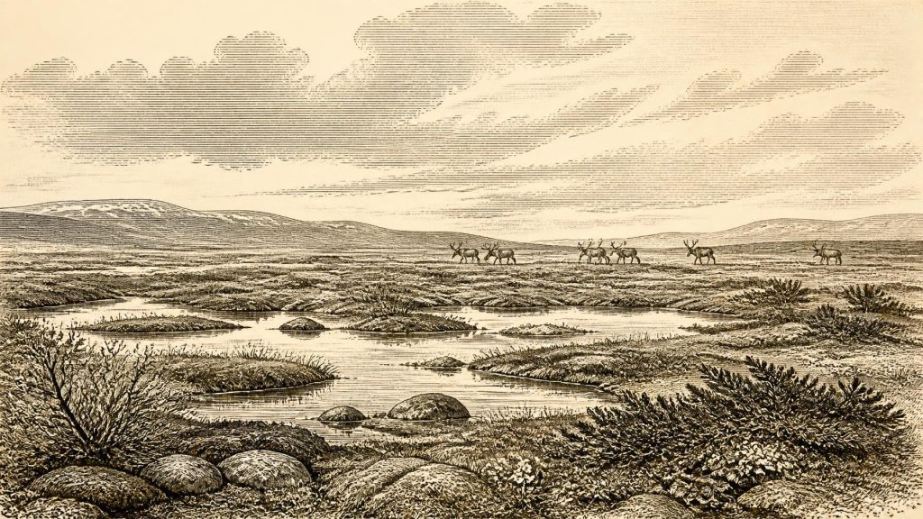
The investigators E. A. Colhoun, J. H. Dickson, A. M. McCabe and F. W. Shotton identified a cold, open environment from the Derryvree fossils. Grasses and sedges were prominent, accompanied by herbs, mosses, juniper and dwarf willow. Mountain avens and bogbean are especially revealing. Bogbean and water-milfoil indicate local fresh water, while dwarf willow and mountain avens are plants well suited to exposed, cold conditions. The evidence is best understood as a treeless, tundra-like wetland or muskeg: uneven, waterlogged ground with shallow pools, mossy margins and brief productive seasons.
Not a Frozen Desert
That description should not conjure an unbroken white wilderness. Derryvree points instead to a patchwork landscape. Low vegetation could take advantage of summer light; sedge banks and mosses trapped organic matter; standing or slow-moving water created sheltered microhabitats; and insects found food among decaying plants. The insect assemblage has been interpreted as one of cold northern aspect, consistent with a severe periglacial climate. Frost, seasonal freezing and sparse tree cover would have shaped soils and slopes, while wind exposure and winter cold constrained plant growth.
It was nevertheless a living landscape. A shallow pool might support aquatic plants while a few metres away a sedge margin, gravelly frost-heaved surface or dwarf-shrub patch offered quite different conditions. The vegetation did not amount to forest, and there is no basis for imagining the familiar oak, hazel and elm woodlands of later prehistoric Ireland. The environmental record instead shows the resilience of cold-adapted plant communities at the edge of shifting ice.
Other Fermanagh sites reinforce the broader point without producing a neat annual sequence. Organic deposits at Hollymount near Maguiresbridge and at Greenagho near Belcoo show that cold, non-glacial intervals occurred during the Midlandian. In south-west Ireland, stalagmites from Crag Cave record episodic phases of calcite growth during milder Greenland-interstadial conditions. Such evidence demonstrates that climatic change in and around Ireland was abrupt and uneven on long human timescales. It does not permit a weather report for 30,397 BCE, but it cautions against treating the Ice Age as climatically uniform.
Animals and a Connected Landscape
Caves in southern Ireland, above all Castlepook Cave near Doneraile in County Cork, provide a second kind of evidence. Their Pleistocene deposits have yielded remains attributed to woolly mammoth, reindeer, giant deer, brown bear, wolf, Arctic fox, lemmings and spotted hyaena. Together they show that Ireland was, at intervals before the Last Glacial Maximum, part of a wider north-west European ecological world. Large herbivores could use open vegetation; predators and scavengers followed opportunities created by those animals; small cold-adapted mammals signal harsh conditions.
But a cave-bone assemblage is not a census of animals living together on one day. Castlepook’s deposits accumulated through different episodes and have been affected by carnivore activity, water movement, excavation and later reassessment. Improved radiocarbon methods have also shown that some earlier determinations need reconsideration. A mammoth bone, hyaena bone and reindeer bone from the same cave need not be contemporary with one another, and neither can automatically be matched with the Derryvree wetland. The secure conclusion is broad: varied cold-stage fauna reached or occupied Irish landscapes during Marine Isotope Stage 3.
The presence of such fauna also implies regional change. Lower sea levels exposed far more land around Ireland and Britain than exists today, though coastlines and possible movement routes changed repeatedly as ice grew, sea level fell and glaciers redirected drainage. Ecological connection did not mean easy or permanent passage. Animals and any people moving through this world faced shifting terrain, cold seas, river valleys, ice margins and seasonal scarcity. Ireland was neither the geographically isolated island of the modern map nor a simple extension of continental Europe.
People: A Serious but Unsettled Question
One Castlepook reindeer femur has been reported as bearing a deep mark interpreted by zooarchaeologist Ruth Carden as stone-tool damage incurred during carcass processing. If that interpretation is confirmed, it would be potentially transformative evidence for human activity in Ireland far earlier than the well-established post-glacial record. It should not, however, be inflated into proof of a settled population, a named Upper Palaeolithic culture, or an event in this particular year. The bone’s date concerns the animal, while identifying a mark as human-made is a separate taphonomic judgement. Researchers still seek securely stratified stone tools, hearths or repeated unequivocal modified bones.
Accordingly, settlement is not demonstrated for Ireland around this date. There are no securely dated houses, campsites, burials, tool-production floors, middens or monuments. Nor is there evidence from which to identify families, territories, leaders, languages or political communities. Comparisons with Upper Palaeolithic groups elsewhere in Europe show that highly mobile foragers could possess sophisticated practical knowledge, social ties and symbolic traditions. Those comparisons make a short Irish visit plausible; they cannot transfer French, British or continental sites wholesale into the Irish record.
Economy Without an Economy
There is similarly no direct evidence for Irish farming, trade or a regular exchange network. Agriculture lay far in the future. If people reached Ireland, reindeer and other large animals would have offered possible meat, marrow, hide, sinew, antler and bone, while freshwater pools and sheltered limestone caves could have been valuable resources. These are reasonable possibilities based on animal ecology and hunter-gatherer practice, not demonstrated products of an Irish economy. No quarry, imported raw-material trail, workshop, cache or route of exchange is securely known for this period.
Religion, art and learning remain beyond the evidence. Ireland has yielded no cave art, portable art, ritual deposit, grave or symbolic object securely attributable to this phase. Nor is there evidence for diplomacy, organised warfare, law or institutions. Conflict undoubtedly existed among predators competing for prey and carcasses, and hyaena activity is important in explaining cave-bone accumulations; that is ecological competition, not evidence for human warfare. The silence of the record is historically important: it sets the limit on what this distant Irish past can honestly bear.
Before the Ice Sheet’s Expansion
At the broad scale, this was a world approaching major transformation. Reconstructions of the British–Irish Ice Sheet show substantial growth from about 31,000 calibrated years BP, followed by maximum ice-sheet conditions later, around 26,000–22,000 years BP in the wider reconstruction. The exact timing and extent varied sharply by region, and maps drawn at thousand-year intervals cannot resolve every valley or wetland. Still, the direction of change is clear: advancing and reorganising ice increasingly overprinted earlier landscapes, destroying some habitats and preserving rare fragments such as Derryvree beneath till.
The chief Irish development around the modern label 30,397 BCE is therefore environmental, not political or biographical. Derryvree preserves a cold freshwater margin with sedges, mosses, dwarf willow and aquatic plants between episodes of glaciation. Castlepook preserves an animal archive that testifies to Ireland’s ecological links with Ice Age Europe and raises, but does not settle, the question of very early human presence. Together these remains reveal an Ireland of open ground, short summers, shallow waters and mobile fauna—a changing periglacial landscape whose evidence survives precisely because later ice buried it.
Primary Sources
- A Middle Midlandian Freshwater Series at Derryvree, Maguiresbridge, County Fermanagh, Northern Ireland
- Early Midlandian–Middle Midlandian, Pleistocene, Northern Ireland
- Palaeoecology
- Figure 6.— The Subdivision of the Quaternary Period in Ireland
- Irish Pleistocene Biostratigraphy
- Quaternary Deposits and Glacial Stratigraphy in Ireland
- The Irish Quaternary Fauna Project
- A Reconsideration of the Radiocarbon Dating of the Marine Isotope Stage 3 Fauna from Southern Ireland
- Occurrence of Mammalia Relicts at Site Castlepook Cave
- The Exploration of Castlepook Cave, County Cork
- Pleistocene Vertebrates in the British Isles
- Heritage Artefacts of County Cork
- Ireland’s Palaeolithic Archaeology – Fleeting Footprints in a Frozen Land
- Episodic Speleothem Deposition Tracks the Terrestrial Impact of Millennial-Scale Last Glacial Climate Variability in SW Ireland
- Spatio-Temporal Dynamics of Speleothem Growth and Glaciation in the British Isles
- Growth and Retreat of the Last British–Irish Ice Sheet, 31,000 to 15,000 Years Ago: The BRITICE-CHRONO Reconstruction
- Trimlines, Blockfields and the Vertical Extent of the Last Ice Sheet in Southern Ireland
- Radiocarbon Constraints on the Age of the Maximum Advance of the British–Irish Ice Sheet in the Celtic Sea
- Late Pleistocene Chronostratigraphy and Ice Sheet Limits, Southern Ireland
- The IntCal20 Northern Hemisphere Radiocarbon Age Calibration Curve (0–55 cal kBP)
- IntCal | Radiocarbon Dating Research
- New Insights on the Fauna of Ireland’s Younger Dryas and Early Holocene from Alice & Gwendoline Cave
- The Mesolithic in Ireland: When Was It?