
Bogbean and Mammoth Interval30344 BCE
About 30,344 BCE is a modern label within a broad, uncertain Late Pleistocene interval, not a datable Irish event. Organic freshwater sediments at Derryvree, County Fermanagh, deposited between glacial advances, record treeless periglacial wetlands with bogbean, sedges, mosses, dwarf shrubs and open herbaceous ground. They show that parts of Ireland were not continuously ice-covered before the Last Glacial Maximum, although conditions varied regionally and renewed ice later buried the site. Castlepook Cave, County Cork, preserves MIS 3 remains of mammoth, reindeer, giant deer, bear and hyaena. Possible human bone modification is inconclusive; no evidence establishes settlement, society or specific activity.
Dateline
Modern calendar-year precision is not available for Ireland in 30,344 BCE. The date is a useful label in a modern sequence, not a recoverable year in which a particular Irish event can be placed. At this depth in time, evidence comes from layers of sediment, fossils and scientific dating, each with substantial uncertainty. The most relevant Irish record is part of the Late Pleistocene, within Marine Isotope Stage 3, when climates across north-west Europe changed repeatedly between severe cold and less extreme intervals. Ireland was moving towards the more extensive glaciation of the Last Glacial Maximum, but it was not yet uniformly or permanently sealed beneath ice.
A Broad Date, Not a Dated Year
The closest securely relevant chronological anchor is BIRM-166, a conventional radiocarbon determination from organic freshwater silts at Derryvree near Maguiresbridge, County Fermanagh. It produced an age of 30,500 radiocarbon years before present, with a large uncertainty of +1,170 and −1,030 years. Radiocarbon years are not calendar years: after calibration, the broad interval cited in later scholarship is approximately 36,900–31,700 calibrated years before present, or roughly 34,950–29,750 BCE. The nominal year 30,344 BCE falls within that broad range, but it cannot be assigned a season, a local weather event or a human action.
This distinction matters. The Derryvree deposit records an interval of time, perhaps with interruptions, rather than a single moment. Nor can one wetland in Fermanagh describe every part of Ireland. Its importance is nevertheless exceptional: later ice and sediment buried the organic layer between two tills, preserving evidence that would otherwise have been eroded away. The sequence establishes a local history of glacial occupation, followed by freshwater deposition on ice-free or ice-marginal ground, followed by renewed ice advance.
Fresh Water Beneath a Drumlin
Road works in 1969 cut through a drumlin at Derryvree, about two kilometres north-east of Maguiresbridge. Drumlins are streamlined hills formed from glacial sediment, familiar features in the Fermanagh landscape. In the exposed section, a lower till – the unsorted debris deposited directly by glacier ice – lay beneath silts, fine sands and organic material. A further till covered them. That order is direct physical evidence: ice affected the site before the freshwater sediments formed, and ice returned later to entomb them.
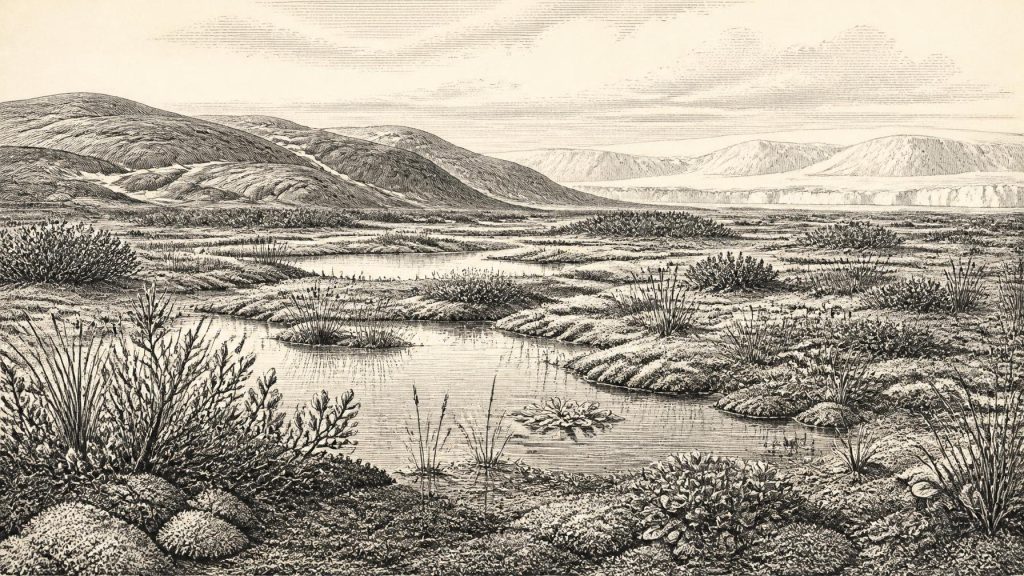
The silts contained poorly preserved herb pollen, plant macrofossils, mosses and small animal remains. Collectively they indicate an open, treeless tundra or muskeg environment under periglacial conditions. “Periglacial” does not mean permanently frozen ground everywhere, nor does it mean that the site lay beneath a glacier. It describes a landscape profoundly shaped by cold: long winters, frost action, limited plant growth, seasonal thaw and proximity to glacial systems. Derryvree was not a featureless white desert. It included wet ground and standing or slow-moving fresh water, but in a climate far harsher than that of modern Fermanagh.
Among the most evocative fossils is bogbean, Menyanthes trifoliata, a wetland plant whose recognisable seed was found in the deposit. Water-milfoil, sedges, grasses, mosses, dwarf willow, mountain avens, juniper and other cold-tolerant plants add detail to the reconstruction. Some grew at or near wet margins; others imply sparse vegetation on exposed ground. The evidence does not permit a painting-like map of every slope and pool, but it supports a mosaic of shallow water, sedgy or mossy margins, open herbaceous ground and scattered low shrubs. There is no credible evidence for woodland at Derryvree at this point.
An Island Before Maximum Ice
The Derryvree sequence is a corrective to any simple image of Ice Age Ireland as continuously ice-covered. Yet it must not be stretched into a claim that the whole island was hospitable. Ice-sheet evidence, offshore records and later glacial landforms show a highly mobile system. Conditions differed between northern interior basins, uplands, Atlantic coasts, limestone districts and the Irish Sea basin. Even within a generally cold phase, local glaciers, snowfields, frozen ground, meltwater channels and ice-free pockets could coexist.
The great maximum of the last British–Irish Ice Sheet came later, broadly during the interval around 27,000–23,000 calibrated years before present in Irish reconstructions, with regional advances and retreats that did not occur everywhere at once. Around the broad period represented by Derryvree, therefore, Ireland was on a changing threshold rather than at the final maximum. Renewed ice eventually overran the Fermanagh wetland, and that later burial both destroyed surrounding landscapes and preserved this narrow archive beneath the drumlin.
Sea level was much lower than it is today because water was held in continental ice sheets. Exposed shelf land and changing coastlines altered the geography around Ireland, Britain and continental Europe. However, lower sea level alone does not demonstrate a simple, continuous land bridge into Ireland at 30,344 BCE. Routes would have depended on shifting shorelines, channels, ice margins and local terrain. The responsible conclusion is that movements of animals, and perhaps people, must be studied case by case rather than assumed from a modern map or a single sea-level estimate.
Mammoths in the Southern Record
Southern Ireland supplies a different kind of evidence. Castlepook Cave near Doneraile, County Cork – also known as Mammoth Cave – has yielded Ireland’s richest Pleistocene vertebrate assemblage. Its remains include woolly mammoth, reindeer, giant deer, brown bear and spotted hyaena. Revised dating of parts of the cave fauna places important episodes in Marine Isotope Stage 3, before the Last Glacial Maximum. These animals demonstrate that cold-stage mammals reached, or persisted in, Ireland during a period when the island’s connections and habitats differed greatly from those of today.
They should not, however, be assembled into a single scene dated precisely to 30,344 BCE. Cave collections often combine material deposited over long spans; nineteenth- and early twentieth-century excavation methods also left imperfect contextual records. A mammoth bone, a hyaena tooth and a reindeer limb bone from Castlepook can establish the former presence of particular animals or predators, but not necessarily that all were alive together, nor that they ranged across every Irish region at the same time. The most defensible picture is of varied, intermittently available cold-open habitats supporting large herbivores and carnivores over the wider MIS 3 period.
A reindeer femur from Castlepook has been interpreted as bearing a deep mark made by a sharp stone tool on fresh bone. If that interpretation is confirmed, it may represent extraordinarily early evidence for human handling of an animal in Ireland. Its implications are important, but narrow. The bone is not a sealed camp floor, and no securely associated hearth, dwelling, burial, stone-tool assemblage or repeated occupation surface of comparable antiquity has been recovered. It cannot prove a permanent population, identify a named people or establish how long any visitors remained. The better-known evidence for repeated human settlement in Ireland belongs far later, after the last major ice retreat.
Society Beyond Recovery
There is no evidence from Ireland around this notional year for political authority, diplomacy, warfare, laws, farming communities, trade institutions, religious monuments, writing or formal learning. Terms such as kingdom, tribe, economy and settlement must not be projected backwards merely because they are useful for later Irish history. Nor should mainland European Upper Palaeolithic art, tools or social customs be treated as Irish evidence. Ireland has not produced a demonstrable contemporary village, house, grave, shrine or workshop.
If people briefly reached the island, their immediate concerns would probably have been practical: movement through an unstable cold landscape, shelter, fuel, food and safe passage. That is an inference from human ecology, not a fact recovered from an Irish camp. Reindeer, if encountered, could have offered meat, marrow, hide, sinew, antler and bone, but the Castlepook femur cannot tell us which resources were taken or whether hunters killed the animal themselves. Predation and scavenging are more securely indicated by the animal assemblages than any human social relationship.
The Evidence’s Real Importance
The history of Ireland around 30,344 BCE is therefore not a narrative of rulers or battles. It is a history of survival and preservation. At Derryvree, a shallow freshwater environment supported hardy plants and small creatures between episodes of glaciation. At Castlepook, cave deposits preserve traces of large mammals and predators from a changing southern landscape. Together, these records show that Late Pleistocene Ireland was environmentally varied, ecologically connected to wider north-west European worlds at times, and increasingly vulnerable to renewed ice expansion.
They also reveal why certainty is limited. Later glaciers scoured much of the surface, moved sediments and removed evidence; cave deposits accumulated irregularly; radiocarbon dates carry ranges; and plant or bone finds illuminate particular places, not a complete island-wide census. The appropriate historical conclusion is modest but substantial. In the broad interval that includes 30,344 BCE, parts of Ireland contained cold, open, wetland-fringed landscapes rather than uninterrupted ice, while large mammals had occupied the island during the wider period. Everything more specific – a particular journey, hunt, settlement or ceremony in that numbered year – remains beyond the evidence.
Primary Sources
- A Middle Midlandian Freshwater Series at Derryvree, Maguiresbridge, County Fermanagh, Northern Ireland
- Trimlines, Blockfields and the Vertical Extent of the Last Ice Sheet in Southern Ireland
- Palaeoecology
- The Subdivision of the Quaternary Period in Ireland
- Quaternary
- Geology of Ireland
- Introduction to the Late Quaternary and Holocene of Northern Ireland
- Introduction to the Glacial Sand and Gravel Landscapes of Northern Ireland
- Cork County Geological Site Report: Castlepook Cave
- A Reconsideration of the Radiocarbon Dating of the Marine Isotope Stage 3 Fauna from Southern Ireland
- Occurrence of Mammalia Relicts at Site Castlepook Cave
- Pleistocene Vertebrates in the British Isles
- New Insights on the Fauna of Ireland's Younger Dryas and Early Holocene from Alice & Gwendoline Cave
- Radiocarbon Constraints on the Age of the Maximum Advance of the British-Irish Ice Sheet in the Celtic Sea
- New Data for the Last Glacial Maximum in Great Britain and Ireland
- Timing and Pace of Ice-Sheet Withdrawal Across the Marine–Terrestrial Transition West of Ireland During the Last Glaciation
- Deglacial Rates and Controls for BIIS Western Margin
- Menyanthes trifoliata
- The Irish Quaternary Fauna Project
- Landscapes and Environments of the Last Glacial-Interglacial Transition: A Time of Amazingly Rapid Change in Ireland
- Irish Pleistocene Biostratigraphy
- Sedimentary Ancient DNA Reveals Late Pleistocene Faunal Connectivity Between Ireland and Eurasia
