
Derryvree’s Freshwater Succession30223 BCE
Thirty thousand years BCE is not a recoverable Irish historical year but falls within a broad Late Pleistocene range. At Derryvree, County Fermanagh, freshwater sediments between glacial tills record an ice-free wetland interval, dated approximately 36,900–31,700 calibrated years BP. Plant and insect remains indicate cold, treeless tundra-steppe conditions before expanding ice sheets reshaped Ireland. Cave faunas, notably Castlepook’s, demonstrate connections with north-west European ecosystems, including reindeer, mammoth, giant deer and predators. No secure human settlement exists; a possibly cut reindeer bone suggests only uncertain contact. Evidence supports changing environments and intermittent access, not political, cultural or social reconstruction in detail.
Dateline
The label 30,223 BCE is a modern point on a chronological scale, not a recoverable Irish calendar year. No written record, named community, excavation layer or securely dated human occupation can be pinned to it. In radiocarbon convention it lies roughly 32,172 years before AD 1950, but radiocarbon ages of this antiquity calibrate to wide calendar ranges. The responsible subject is therefore Ireland around this point: Late Pleistocene Ireland in Marine Isotope Stage 3 (MIS 3), during the last glacial cycle but before the fullest expansion of the last Irish Ice Sheet. The evidence is geological, palaeobotanical and faunal, and it records changing environments rather than historical events.
A Date Within a Broad Range
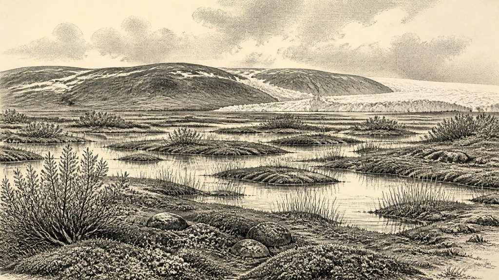
The closest and most informative Irish record is at Derryvree, near Maguiresbridge in County Fermanagh. Roadworks in 1969 cut through a drumlin and revealed freshwater silts, fine sands and organic layers trapped between two thick tills: unsorted debris left by glacier ice. The stratigraphic sequence is important. A glacier had first occupied the site and laid down the lower till; later, water, plants and small animals occupied an ice-free basin long enough for sediment to gather; subsequently, renewed ice laid down the upper till and sealed that local archive.
Organic material from the Derryvree freshwater beds produced the conventional radiocarbon determination BIRM-166, 30,500 radiocarbon years BP, with a substantial uncertainty of +1,170 and −1,030 years. Later discussion has placed the material broadly at about 36,900–31,700 calibrated years BP, approximately 34,950–29,750 BCE. Thus 30,223 BCE falls inside the broad calibrated span, but cannot be assigned to a particular pool, plant, animal, season or generation within it. Derryvree is evidence for a local interval of open water and wet ground, not a complete map of conditions across Ireland.
Cold Wetlands Before the Maximum
The Derryvree deposits preserve a cold, largely treeless environment. Plant and insect evidence has been interpreted as an open tundra or tundra-steppe mosaic: sedges and mosses beside shallow freshwater, with Arctic-alpine herbs and dwarf shrubs in better-drained patches. Such a landscape should not be imagined as a motionless snowfield. Summer thaw, standing water, frost-heaved soils, windswept ground and brief productive growing seasons could exist alongside severe winter cold. The key point is instability. MIS 3 climate was marked by abrupt shifts, and Irish cave-flowstone records show that intervals conducive to soil-water movement and calcite growth occurred episodically in south-west Ireland.
At this horizon Ireland was approaching a major transformation rather than enjoying a settled environmental regime. A synthesis of the glacial evidence suggests that much of the island remained ice-free until about 32,000 years ago, after which the last Irish Ice Sheet expanded and thickened. That broad estimate is close to the date in question, and should not be converted into a claim that all regions changed simultaneously. Fermanagh’s buried wetland demonstrates that ice advance and retreat were spatially uneven. It also explains why the evidence is so fragmentary: later glaciers eroded, displaced or buried much of the older land surface.
Animals in a Changing Landscape
Cave collections, especially from Castlepook Cave near Doneraile in north County Cork, show that Ireland supported a striking pre-Last Glacial Maximum fauna over the longer period from at least about 45,000 to 20,000 years ago. Directly dated remains include reindeer, woolly mammoth, giant deer, brown bear, spotted hyaena, Arctic fox and lemmings, alongside wolf, hare and other species. These animals did not necessarily coexist at Castlepook on one day: cave deposits accumulated over long intervals, were excavated antiquarily, and in places were reworked by water. Nevertheless, the assemblage establishes that Ireland was repeatedly part of a wider north-west European ecological zone.
For 30,223 BCE, the safest picture is therefore of open, cold country capable of supporting grazing and browsing mammals, their predators and scavengers, rather than of dense woodland. Reindeer are especially apt indicators of cold, open environments, while mammoth, hyaena and giant deer point to connections with continental-style Pleistocene faunas. Animal bones demonstrate that these species reached Ireland during broad phases of the Late Pleistocene; they do not reveal herd numbers, migration routes in a particular year, or the precise appearance of every region. The familiar label “Irish elk” is also misleading: Megaloceros giganteus was neither confined to Ireland nor an elk in the zoological sense.
People: A Possibility, Not a Settlement
There is no securely excavated camp, hearth, stone-tool assemblage, dwelling, burial or human skeleton from Ireland that can responsibly be dated to around 30,223 BCE. The earliest unequivocal archaeological settlement presently discussed in Irish prehistory is vastly later, at Mount Sandel in County Londonderry, first occupied around 9,800–9,700 calibrated years BP. That gap matters: it prevents historians from projecting the social life of later Mesolithic communities back into this much older and poorly documented phase.
A reindeer femur from Castlepook has, however, made the question of earlier visitors newly important. The bone has been presented as bearing a deep incision consistent with fresh-bone work by a sharp stone tool, and its reported age has been widely publicised as roughly 33,000 years old. If that interpretation is confirmed, it would indicate a human action on an animal carcass and would push possible human activity in Ireland far back into MIS 3. It would still not prove a resident population, a cave settlement, a named culture or continuous occupation. The cave’s complicated formation history and the lack of associated artefacts require caution; earlier scholarly examination of Castlepook likewise stressed disturbance and re-sorting of bone deposits.
No Politics, Trade or Ritual Record
Accordingly, political affairs, diplomacy and warfare cannot be reconstructed for Ireland at this date. There are no polities, territorial boundaries, leaders, alliances or conflicts visible in the evidence. Nor is there evidence for trade: the movements of mammoths, reindeer or hyaenas were ecological dispersals, not commerce. A possible episode of carcass processing, if the Castlepook mark proves anthropogenic, would show subsistence activity only. It cannot establish exchange routes, seasonal markets or relations between groups.
The same restraint is needed for society, religion, culture and learning. No art, ornament, grave, shrine, language sample, house floor or structured deposit has been securely linked to Ireland around this horizon. It is possible that small, mobile Upper Palaeolithic groups occasionally ranged through landscapes now represented only by cave bones and buried sediments; it is equally possible that some animal arrivals occurred without people. Absence of evidence is not proof of permanent human absence, particularly where glacier erosion and old excavations have damaged the record. But it is not licence to invent families, rituals, hunting parties or beliefs.
Routes and Regional Change
Lower sea levels during the glacial period exposed large areas now beneath the Irish Sea and Atlantic shelf, changing the size and shape of Ireland’s accessible landscapes. Faunal evidence makes some connection with Britain and continental Europe highly likely during parts of the Late Pleistocene, but the exact routes varied with ice extent, sea level and local topography. A dry, continuous land bridge should not be casually assumed for every phase. Later sea-level modelling indicates that Ireland had become separated from Britain by around 16,000 calendar years ago; that result clarifies the later end of the story, while also underlining how different the earlier, pre-maximum geography was.
Derryvree gives this remote date its most vivid Irish setting: not a kingdom or a battle, but a freshwater basin between episodes of ice. Its organic mud preserves the fact of ecological opportunity—open water, wetland plants and a short-lived non-glacial landscape—before later ice obscured it. Castlepook’s bones add the presence of a wider cold-adapted fauna and a tantalising, unresolved possibility of human contact. Together they make 30,223 BCE an important point in Ireland’s deep past, while reminding us that the proper scale of knowledge is not a year, but broad calibrated ranges and carefully tested evidence.
Primary Sources
- A Middle Midlandian Freshwater Series at Derryvree, Maguiresbridge, County Fermanagh, Northern Ireland
- Episodic Speleothem Deposition Tracks the Terrestrial Impact of Millennial-Scale Last Glacial Climate Variability in SW Ireland
- The Irish Quaternary Fauna Project
- Irish Quaternary Vertebrates
- The Last Irish Ice Sheet: Extent and Chronology
- Deglaciation Chronology of the Donegal Ice Centre, North-West Ireland
- Dimensions and Chronology of the Last Ice Sheet in Western Ireland
- Timing and Pace of Ice-Sheet Withdrawal Across the Marine–Terrestrial Transition West of Ireland During the Last Glaciation
- Investigating Seasonal Mobility in Irish Giant Deer Megaloceros giganteus Through Strontium Isotope Analysis
- Phylogeographic, Ancient DNA, Fossil and Morphometric Analyses Reveal Ancient and Modern Introductions of a Large Mammal: The Complex Case of Red Deer in Ireland
- New Insights on the Fauna of Ireland’s Younger Dryas and Early Holocene from Alice & Gwendoline Cave
- The Colonization of Ireland: A Human Ecology Perspective
- The Island of Ireland: Drowning the Myth of an Irish Land-Bridge?
- Anthropogenic Changes to the Holocene Nitrogen Cycle in Ireland
- Heritage Artefacts of County Cork
- Ireland’s Palaeolithic Archaeology – Fleeting Footprints in a Frozen Land
- Archaeological Excavations at Killuragh Cave, Co. Limerick: A Persistent Place in the Landscape from the Early Mesolithic to the Late Bronze Age
- Pleistocene Glaciations in Ireland
- Ireland: Submerged Prehistoric Sites and Landscapes
- Advances in Irish Quaternary Studies
