
Waterford Red Deer30180 BCE
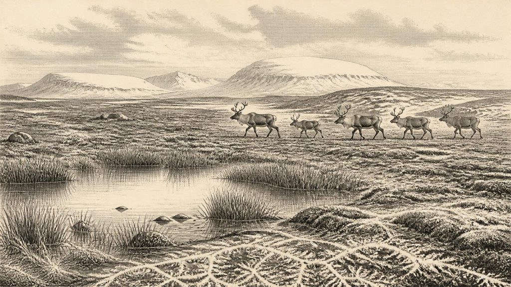
Around 30,180 BCE, Ireland was a changing Pleistocene margin rather than a definable historical society. Dynamic ice sheets, periglacial conditions, low sea levels and unstable routes shaped an exposed, seasonally harsh landscape. Derryvree, County Fermanagh, preserves a locally ice-free wetland episode, whose plants and insects indicate treeless tundra, shallow water and sparse vegetation. Cave finds show that reindeer, red deer, mammoth, bears, wolves, hyaenas and smaller cold-adapted animals reached Ireland during favourable intervals; a Waterford red-deer date overlaps this horizon. A possibly cut-marked Castlepook reindeer bone suggests, but cannot prove, human visits. No evidence supports settlements, farming, institutions or occupation.
Dateline
The label 30,180 BCE is useful as a modern point of reference, but it cannot identify a particular Irish day, season, event or generation. No written calendar existed, and the available evidence was not deposited as an annual record. In archaeological convention, the date lies about 32,130 years before AD 1950, within the later part of the Pleistocene and close to the transition into the cold conditions conventionally associated with Marine Isotope Stage 2. Radiocarbon determinations must be calibrated and carry substantial ranges at this depth of time. The responsible subject, therefore, is not “Ireland in a year”, but an Irish landscape changing across centuries and millennia.
A Changing Ice-Age Island
Ireland stood at the north-western edge of Europe, exposed to the highly variable climate of the North Atlantic. This was not yet the uniformly ice-covered Ireland often imagined for the Last Glacial Maximum, the phase when the final British–Irish Ice Sheet reached its greatest extent roughly between 27,000 and 23,000 calibrated years before present. Yet neither was it a settled green island. Ice masses had already expanded and contracted repeatedly, mountain and lowland ice may have occupied different regions at different times, and periglacial conditions shaped exposed ground beyond the glaciers.
Research does not permit a precise map for 30,180 BCE. Some evidence indicates substantial Irish ice-sheet loading and high relative sea levels on the western coast during the wider interval from about 40,000 to 19,000 calibrated years before present. Other evidence records local ice-free episodes. These findings are not contradictory: they show that an ice sheet was dynamic, with margins, thickness and flow paths changing through time. It would be misleading to claim that all of Ireland was either buried beneath ice or wholly open at this particular point.
For people and animals, the decisive realities were cold, seasonality, wind, snow cover, scarce winter food and shifting routes through a landscape altered by frost and ice. Sea level was far below the modern shoreline, enlarging the surrounding continental shelves, but this did not necessarily create an easy dry-land route to Ireland. Glaciers, meltwater, tidal channels and changing coastlines complicated movement. Much of the evidence for former coastal environments now lies offshore, while later glaciers eroded, redeposited or sealed earlier traces on land.
Derryvree’s Buried Wetland
The clearest Irish environmental archive relevant to this broad era lies at Derryvree near Maguiresbridge in County Fermanagh. Roadworks cut through a drumlin in 1969 and exposed freshwater silts and fine sands trapped between two thick tills. The sequence matters because the lower and upper tills represent glacial deposition, whereas the sediments between them formed when ice was absent locally and water, plants and small animals occupied a basin.
The organic deposits yielded the conventional radiocarbon determination Birm-166, 30,500 radiocarbon years before present, with an uncertainty of about a millennium. Under modern calibration this is broadly earlier than the nominal 30,180 BCE reference point, around the mid-to-late 30,000s calibrated years before present, rather than a single date. Nonetheless, it is invaluable evidence for the type of cold-stage environments that could develop in Ireland before fuller ice-sheet expansion. It must not be presented as a photograph of the whole island, still less as proof of conditions in one particular calendar year.
Plant remains, pollen, mosses and insects from Derryvree indicate open, treeless tundra or muskeg-like ground, with shallow water and wet margins. Sedges, grasses, herbs, dwarf willow, juniper and aquatic plants belonged to a landscape with little or no woodland. A fossil seed of bogbean, Menyanthes trifoliata, is particularly eloquent evidence for freshwater conditions. Such a plant does not make the climate mild: bogbean and other wetland species could survive at sheltered pond edges amid a generally severe periglacial regime.
The insect evidence complements rather than duplicates the botanical record. It suggests organic-rich pools and mossy wet ground, while the surrounding vegetation remained sparse and exposed. In an Ireland now famous for wooded valleys and pasture, this was a radically different ecological setting: low plants, open vistas, frozen or waterlogged ground, and short productive seasons. The later ice that formed the drumlin protected this small archive while also reminding us that its wetland world was temporary.
Reindeer, Deer and Carnivores
The Irish Quaternary Fauna Project established that a varied large-mammal fauna reached Ireland during parts of the period between at least about 45,000 and 20,000 years ago. Cave deposits, especially in the south and south-east, have yielded remains of reindeer, woolly mammoth, giant deer, brown bear, wolf, foxes, hares and lemmings. The survival of bones is uneven and cave assemblages are not simple census lists: carnivores carried carcass parts into caves, water moved sediment, and antiquarian excavators did not record deposits to present standards. Even so, the fauna demonstrates that suitable habitats and movement routes existed during ice-free or less heavily glaciated intervals.
Castlepook Cave, also called Mammoth Cave, near Doneraile in north County Cork is central to this story. Its deposits contain an exceptional Ice-Age assemblage, including mammoth, reindeer, brown bear and spotted hyaena. Reliable dates from the cave place some fauna well before the nominal year considered here: mammoth and hyaena evidence belongs broadly to the mid-30,000s radiocarbon years before present. They illuminate the longer environmental setting but do not prove that those same animals occupied the cave in 30,180 BCE.
Evidence closer in calibrated age comes from south-eastern caves. A directly dated red-deer specimen from County Waterford falls within approximately 32,930–31,280 calibrated years before present, a range that overlaps the broad chronological horizon represented by 30,180 BCE. This is evidence for the animal’s presence, not for a stable island-wide herd or a temperate forest. Reindeer and red deer could occupy different habitats and their dated remains represent separate episodes. The island’s fauna changed as climates and access routes changed.
The mammals also reveal a food web rather than an untouched catalogue of impressive species. Reindeer converted sparse vegetation into meat accessible to predators and scavengers. Hyaenas, wolves and bears competed over carcasses or used caves as dens and refuges. Small mammals such as lemmings and mountain hares point towards open cold-country habitats. Mammoth remains evoke broad grass-herb landscapes, but their occurrence in a cave is likely to reflect carnivore activity and bone transport as much as the exact place where an animal died.
The Human Question at Castlepook
Human history at this horizon is possible, but exceptionally difficult to demonstrate. A reindeer femur from Castlepook has been reported as bearing a deep incision interpreted by zooarchaeologist Ruth Carden as a stone-tool cut made during fresh-bone processing. The bone was reported as about 33,000 radiocarbon years old and is often described in public interpretation as evidence for Palaeolithic people in Ireland around 31,000 BCE. If the modification is confirmed as human-made, it would be an important indication that people reached the island far earlier than the formerly accepted terminal-Pleistocene evidence.
That conclusion needs careful limits. The radiocarbon result dates the animal’s death, not the exact moment of cutting, and a single marked bone from an old collection cannot establish a settlement, a population, a named cultural group or a permanent occupation. No securely associated stone-tool assemblage, hearth, dwelling floor, burial or human remains of comparable age has been published from Castlepook. Carnivores and complex cave taphonomy are alternative explanations for how bones entered the cave, though not necessarily for every surface mark. Current excavation and re-dating programmes are important precisely because the original deposits were excavated more than a century ago.
It follows that Ireland’s political affairs, diplomacy, warfare, religious institutions, languages and formal learning are beyond recovery for this date. There are no chiefs, territories, treaties or cult sites that can responsibly be named. Nor can a social structure be inferred from one potentially modified bone. If people did visit, the most cautious interpretation is of short-lived, mobile foraging excursions in a wider north-west European world, perhaps linked to the movements of game. That is an interpretation from ecological context, not direct proof of a hunting party at Doneraile.
Economy Without Settlements
There is no evidence for farming, herding, metalworking, pottery, trade centres or permanent villages in Ireland at this time. The only plausible human economy, if humans were present at all, would have been hunting, scavenging and the flexible use of animal and plant resources. Reindeer would have offered meat, fat, hide, sinew, antler and bone; yet none of these uses can be demonstrated in detail for Irish people at this date. The distinction matters. European Upper Palaeolithic communities elsewhere made sophisticated tools, ornaments and images, but it would be unsound to transfer their material culture automatically to Ireland without Irish finds.
The strongest story is instead one of environmental thresholds. Ireland was a periodically accessible but climatically demanding margin of north-west Europe. Open wetland survived in Fermanagh during one cold-stage interval; sizeable grazing animals and carnivores occurred in southern cave landscapes during others; and ice later transformed much of the terrain, destroying or concealing evidence. Around 30,180 BCE, Ireland was not a political landscape in any recoverable sense. It was a changing Pleistocene environment in which animal movement, ice-sheet growth and rare traces of possible human contact offer the first, fragmentary beginnings of the island’s archaeological story.
Primary Sources
- A Middle Midlandian Freshwater Series at Derryvree, Maguiresbridge, County Fermanagh, Northern Ireland
- The Irish Quaternary Fauna Project
- Phylogeographic, Ancient DNA, Fossil and Morphometric Analyses Reveal Ancient and Modern Introductions of a Large Mammal: The Complex Case of Red Deer (Cervus elaphus) in Ireland
- Radiocarbon Constraints on the History of the Western Irish Ice Sheet Prior to the Last Glacial Maximum
- Response of the Irish Ice Sheet to Abrupt Climate Change During the Last Deglaciation
- Growth and Retreat of the Last British–Irish Ice Sheet, 31,000 to 15,000 Years Ago: The BRITICE-CHRONO Reconstruction
- The Timing and Magnitude of the British–Irish Ice Sheet Between Marine Isotope Stages 5d and 2: Implications for Glacio-Isostatic Adjustment, High Relative Sea Levels and ‘Giant Erratic’ Emplacement
- Trimlines, Blockfields and the Vertical Extent of the Last Ice Sheet in Southern Ireland
- Timing and Pace of Ice-Sheet Withdrawal Across the Marine–Terrestrial Transition West of Ireland During the Last Glaciation
- The Deglaciation of the Western Sector of the Irish Ice Sheet From the Inner Continental Shelf to its Terrestrial Margin
- Radiocarbon Constraints on the Age of the Maximum Advance of the British–Irish Ice Sheet in the Celtic Sea
- Dimensions and Chronology of the Last Ice Sheet in Western Ireland
- New Data for the Last Glacial Maximum in Great Britain and Ireland
- The IntCal20 Northern Hemisphere Radiocarbon Age Calibration Curve (0–55 cal kBP)
- A Stratigraphic Framework for Abrupt Climatic Changes During the Last Glacial Period Based on Three Synchronized Greenland Ice-Core Records: Refining and Extending the INTIMATE Event Stratigraphy
- Menyanthes trifoliata
- Quaternary
- Heritage Artefacts of County Cork
- 2022:564 – Castlepook Cave, Castlepook South, Cork
- Archaeology Research Excavation Grant 2022: Final Report
