Mosses Beneath Fermanagh30995 BCE
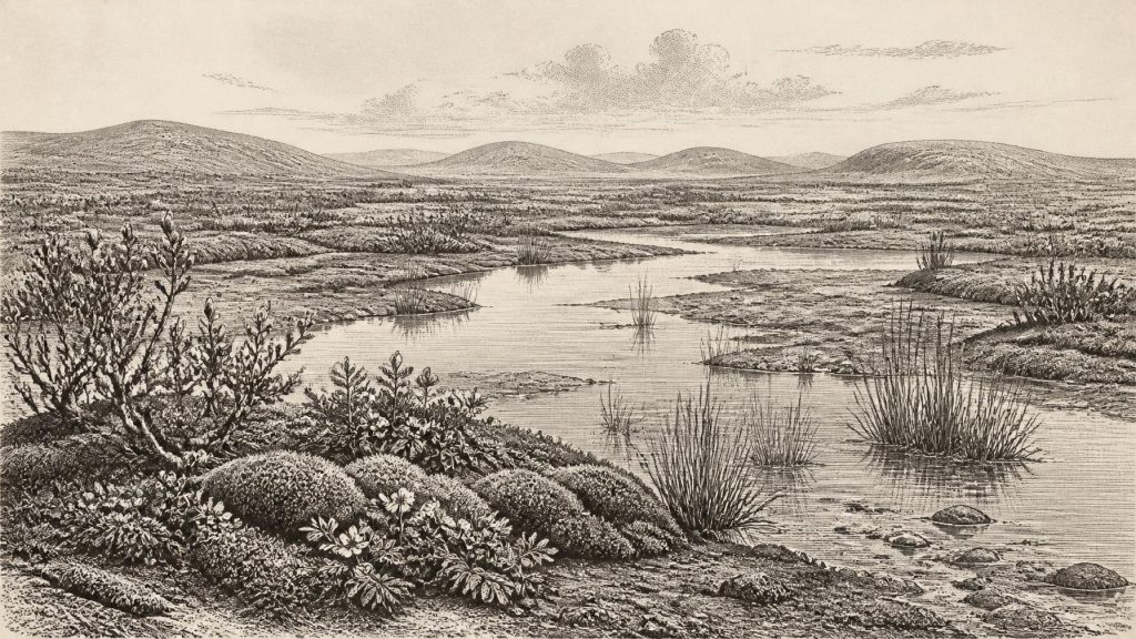
Although 30,995 BCE cannot be treated as a precise Irish historical year, it falls within MIS 3, when climates and ice margins fluctuated. At Derryvree, County Fermanagh, freshwater sediments between glacial tills preserve evidence of a locally ice-free wetland, with tundra vegetation including mosses, aquatic plants, dwarf willow and mountain avens. Castlepook Cave in Cork records diverse Ice Age fauna, though its long accumulated deposits cannot establish contemporaneous animal communities. A possibly modified reindeer bone raises, but does not prove, early human presence. No secure Palaeolithic settlement evidence currently exists. Later glaciation reshaped landscapes and destroyed or buried much evidence.
Dateline
The label 30,995 BCE gives an apparent precision that the evidence cannot sustain. No written calendar, named individual, settlement horizon or event can be assigned to that year in Ireland. In calibrated archaeological terms, it falls roughly 32,944 years before AD 1950, within the Late Pleistocene, Marine Isotope Stage 3 (MIS 3), and the Irish regional sequence often called the Middle Midlandian. The responsible history of this point is therefore not a chronicle of a single year, but an account of a changing Ice Age landscape, reconstructed from buried sediments, animal bones, plant remains and the geometry of later glaciers.
The most closely relevant evidence comes from Derryvree, near Maguiresbridge in County Fermanagh. There, a road cutting made in 1969 exposed freshwater silts and fine sands enclosed between two layers of glacial till beneath a drumlin. The lower till shows that ice had previously crossed the ground; the organic sediments record a period in which open water and wet ground existed locally; the upper till demonstrates that ice later returned. Organic material from the freshwater bed produced a conventional radiocarbon determination of 30,500 +1,170/−1,030 BP. Calibrated with modern curves, the broad uncertainty range is approximately 36,900–31,700 cal BP, or about 34,950–29,750 BCE. The date under consideration lies within that span, but not at a point that can be isolated in the deposit.
A Landscape Between Ice Advances
Derryvree matters because it preserves a rare Irish record from a time when later glaciation destroyed or buried much of the evidence. Its sequence does not prove that all Ireland was ice-free at once. It establishes something more limited, but still important: during part of this wide interval, south Fermanagh contained a freshwater environment not occupied by glacier ice. The site was part of a landscape repeatedly altered by cold-climate processes. Freeze-thaw fractured ground; thin soils were vulnerable to wind and runoff; and seasonal meltwater redistributed silt and sand. A drumlin now conceals the former wetland, a striking reminder that the visible Irish landscape is often younger than the deposits below it.
The wider picture is one of instability rather than a simple march towards an Ice Age maximum. Research on the British–Irish Ice Sheet indicates growth, retreat and renewed advances during the last cold stage. The great maximum came later: the ice sheet reached its largest known extent in the Irish sector principally around 25,000–23,000 BP, while advances and maxima varied markedly between regions. Southern Irish deposits show that some raised beaches and shallow-marine sediments formed during MIS 4–3, before glacigenic deposits dating to after about 24,000 cal BP. At around the notional date considered here, Ireland stood in a long transition towards more severe and extensive glaciation, not yet in the fully developed Last Glacial Maximum familiar from maps of an ice-covered island.
That distinction is essential. It would be misleading to picture a uniform white expanse, but equally misleading to imagine a temperate, wooded Ireland. Local circumstances differed between coasts, lowlands and uplands, and the ice margin itself moved over long timescales. Lower global sea level altered coastlines and exposed parts of the continental shelves. Yet there is no basis for drawing a precise shoreline for 30,995 BCE, or for assuming an easy land route by which every animal or person could have travelled. Connections between Ireland, Britain and continental Europe changed with sea level, ice and the availability of habitable terrain.
The Derryvree Wetland
The fossils in the Derryvree freshwater bed offer the clearest view of everyday life in this Irish environment—not human everyday life, but that of plants and waters. The deposits contained poorly preserved pollen, mosses and plant macrofossils. Together they indicate open, tundra-like vegetation and a periglacial climate. The record includes plants associated with damp ground and pools, among them bogbean (Menyanthes trifoliata) and alternate water-milfoil (Myriophyllum alterniflorum), as well as dwarf willow (Salix herbacea) and mountain avens (Dryas octopetala). Such finds show that a cold freshwater mosaic could support aquatic plants, mossy margins and low-growing vegetation even in a largely treeless setting.
Evidence is strongest at the scale of habitat. It can support an interpretation of shallow water, wet sediment and sparse open ground, rather than a detailed map of every plant community. A pollen grain may have travelled; macrofossils generally speak more closely to their source, but a single basin never represents an entire island. Nor do these fossils establish the precise season in which a plant flowered, the duration of the pond, or the temperature of a particular winter. Their value lies in demonstrating that a small but biologically varied refuge existed between episodes of ice cover.
This was not the later Ireland of dense oak woodland, peat bogs, enclosed fields or familiar lakeside farms. Trees, if present locally at all, were not the defining feature of the Derryvree landscape. The resources available to animals would have been seasonal and patchy: herbaceous plants on exposed ground, browse from low willow, and water-associated vegetation around pools and drainage lines. The phrase ‘tundra’ should not conjure an empty wasteland. It denotes an open cold-climate ecosystem, capable of sustaining distinctive plant communities and, elsewhere in Ireland, substantial mammals.
Caves, Animals and a Human Question
County Cork’s Castlepook Cave, near Doneraile, provides the principal southern counterpart to Derryvree. It is Ireland’s richest known site for vertebrate remains from the middle and later part of the Ice Age before the Last Glacial Maximum. More than 2,000 bones recovered from its deposits have yielded dates spanning roughly 45,700–19,950 BP. The assemblage includes woolly mammoth, giant deer, reindeer, brown bear and spotted hyaena; later material includes lemmings, Arctic fox and wolf. These remains show that Ireland supported, at different times, a much richer large-mammal fauna than the island of later millennia.
But a cave bone assemblage is not a census taken in one season. Castlepook’s deposits accumulated across many thousands of years, and water disturbance has affected parts of the site. Some carcasses may have been brought in by hyaenas, scavengers or natural processes. Modern redating has also demonstrated that older radiocarbon results from Irish caves can require substantial revision. Consequently, the assemblage is strong evidence for the presence of Ice Age animals in southern Ireland during MIS 3; it is not proof that mammoths, giant deer, hyaenas and reindeer all stood together outside the cave in 30,995 BCE.
The possibility of people in Ireland at this deep date must be handled with equal care. A reindeer bone from Castlepook has been directly dated to about 33,000 years ago and carries a mark that has been discussed as potentially human-made. If that interpretation is confirmed, it would radically extend the known human story of Ireland. Yet there is no securely excavated Upper Palaeolithic hearth, tool assemblage, dwelling surface or cemetery from this time on the island. The National Museum of Ireland therefore continues to state that no clear evidence demonstrates human presence in Palaeolithic Ireland. For now, the bone is an important research question, not a foundation for a confident narrative of resident hunters.
Society Without a Social Record
There is no evidence from which to identify a polity, chiefdom, territory, alliance, conflict or diplomatic exchange in Ireland at this date. There are no inscriptions, monuments, weapons, houses or burials attributable to a human community around 30,995 BCE. It is equally impossible to demonstrate trade, sea crossings, religious practice, language, teaching or artistic traditions. These absences are not minor gaps: they define the limits of what can responsibly be said.
If people did occasionally reach Ireland during MIS 3, they would have needed practical knowledge of weather, animal movement, stone and organic materials, route-finding and food preservation. That is a reasonable general inference from Upper Palaeolithic lifeways elsewhere in north-west Europe, not direct evidence for Irish society. No Irish find presently permits us to say whether such visitors camped, hunted, crossed from Britain, returned elsewhere, or formed a continuing population. The strongest established story remains environmental: plants persisted in cold wet ground, animals moved through changing habitats, and glaciers were preparing to erase or bury much of the evidence.
What Survives of This Moment
For Ireland, the importance of this notional year lies in the tension between survival and loss. Derryvree’s mosses, sedges and aquatic plants record a locally ice-free freshwater world in the broad interval that includes it. Castlepook records animal communities able to reach and inhabit parts of the island before the climatic maximum. The subsequent expansion of ice transformed those landscapes, reworked deposits and sharply reduced the chance that traces of people would endure.
Thus 30,995 BCE is best understood neither as the beginning of Irish settlement nor as a year of known action. It represents a narrow calendar label placed upon a long, uncertain interval. Beneath a Fermanagh drumlin, the silts preserve the most intimate evidence available: the remains of plants that grew beside cold water while Ireland’s Ice Age geography was still in motion.
Primary Sources
- A Middle Midlandian Freshwater Series at Derryvree, Maguiresbridge, County Fermanagh, Northern Ireland
- Palaeoecology: Middle Midlandian Palaeoenvironment of South Fermanagh
- Figure 6: The Subdivision of the Quaternary Period in Ireland
- BSBI: Salix herbacea
- BSBI: Menyanthes trifoliata
- BSBI: Dryas octopetala
- BSBI: Myriophyllum alterniflorum
- Castlepook Cave: County Geological Site Report
- Spotted Hyena Skull
- Prehistoric Details
- A Reconsideration of the Radiocarbon Dating of the Marine Isotope Stage 3 Fauna from Southern Ireland
- Archaeology Research Excavation Grant 2022: Final Report
- The Archaeological Heritage of County Cork
- Growth and Retreat of the Last British–Irish Ice Sheet, 31,000 to 15,000 Years Ago: The BRITICE-CHRONO Reconstruction
- Growth and Retreat of the Last British–Irish Ice Sheet, 31,000 to 15,000 Years Ago: The BRITICE-CHRONO Reconstruction
- Late Pleistocene Chronostratigraphy and Ice Sheet Limits, Southern Ireland
- Stratigraphic and Palaeo-Geomorphological Evidence for the Glacial-Deglacial History of the Last British-Irish Ice Sheet in the North-Western Irish Sea
- Early Deglaciation of the British-Irish Ice Sheet on the Atlantic Shelf Northwest of Ireland Driven by Glacioisostatic Depression and High Relative Sea Level
- The Timing and Magnitude of the British–Irish Ice Sheet Between Marine Isotope Stages 5d and 2
- The IntCal20 Northern Hemisphere Radiocarbon Age Calibration Curve (0–55 cal kBP)
- New Insights on the Fauna of Ireland’s Younger Dryas and Early Holocene from Alice & Gwendoline Cave
- Investigating Seasonal Mobility in Irish Giant Deer (Megaloceros giganteus Blumenbach)
