
Maguirebridge’s Buried Buckbean30218 BCE
Around 30,218 BCE, Ireland’s history is reconstructed from environmental evidence rather than written records. At Derryvree near Maguiresbridge, freshwater silts preserved beneath later glacial till indicate a brief ice-free interval between glaciations. Buckbean, sedges, mosses, grasses and cold-tolerant shrubs reveal shallow wetlands within open tundra under severe periglacial conditions. Ireland was climatically uneven as ice accumulated elsewhere, not wholly frozen or forested. Southern cave finds show that cold-adapted mammals inhabited the wider region, although their dates and associations remain uncertain. A possibly cut-marked reindeer bone may indicate a transient human visit, but no evidence confirms settlement, institutions, culture or economy.
Dateline
Modern calendar-year precision is not available for Ireland in 30,218 BCE. Nobody on the island recorded a year, and the surviving evidence cannot be tied to a particular season, generation or event. The label is best understood as a modern point approximately 32,167 years before AD 1950, within the Late Pleistocene and Marine Isotope Stage 3. The closest Irish evidence is not an annal of people or politics but a buried environmental archive at Derryvree, near Maguiresbridge in County Fermanagh. There, freshwater sediments preserve a short-lived world of cold water, low vegetation and animal life that existed between episodes of glaciation. The responsible history of this notional year is therefore a history of ranges, layers and probabilities.
A Date Within a Range
The key determination from Derryvree, laboratory sample BIRM-166, gave a conventional radiocarbon age of 30,500 years BP, with an uncertainty of +1,170 and −1,030 years. A radiocarbon age is not the same thing as a calendar age: atmospheric carbon-14 has varied through time, and very old results require calibration against internationally maintained curves. Recent modelling places the Derryvree evidence broadly in the earlier part of the last glacial cycle’s great advance, with an estimated calendar age around 33,500 years before present and a substantial uncertainty. Consequently, 30,218 BCE falls near, rather than precisely upon, the time-range for which the deposit is informative.
This caution is important. It would be wrong to claim that a particular pool, willow shrub, reindeer or human visitor was present at Maguiresbridge in this exact numbered year. Yet the date lies close enough to the Derryvree interval to illuminate the kind of Irish environment then possible: locally ice-free ground in a severe, unstable climatic setting, before later glaciers covered and protected the deposit. It is an unusually valuable survival because advancing ice commonly scoured away the soils and land surfaces of this age.
Freshwater Beneath a Drumlin
Road works in 1969 cut through a drumlin at Derryvree, about two kilometres north-east of Maguiresbridge. The exposure revealed a simple but powerful sequence. A lower till, the unsorted debris laid down by glacier ice, was overlain by freshwater silts and fine sands containing organic remains. Above those lay a second, thick till. The stratigraphy demonstrates an interval between two glacial episodes: ice had occupied or affected the locality, then water and vegetation accumulated in a depression, and a subsequent advance buried the evidence beneath fresh glacial sediment.
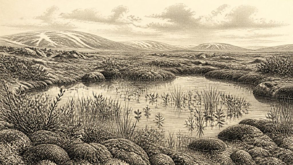
The organic bed is not evidence for a mild or wooded Ireland. Its flora and fauna indicated open tundra vegetation and a periglacial climate: conditions shaped by intense cold, frost action and a short growing season, though not necessarily by a glacier standing at the spot. The waterlogged sediments contained remains of grasses, sedges, mosses and herbs. They also preserved buckbean, Menyanthes trifoliata, a plant of shallow freshwater and wet margins, alongside evidence associated with dwarf willow and other cold-tolerant plants. Together these remains suggest a patchwork of shallow pools, sedgy edges, mossy ground and exposed mineral soils rather than continuous forest.
An Uneven Ice-Age Island
Derryvree should not be turned into an island-wide weather report. It establishes that this Fermanagh locality supported freshwater and tundra vegetation during the period represented by the silts; it does not prove that every valley, coast or upland in Ireland was ice-free at the same time. Ireland’s landscape was changing on regional and millennial scales. Greenland ice-core records show that the North Atlantic climate of Marine Isotope Stage 3 was marked by abrupt shifts between colder stadials and relatively milder interstadials. Irish conditions responded to that wider instability through changing snow cover, permafrost, vegetation and ice margins.
Large-scale reconstruction of the British–Irish Ice Sheet indicates that, from about 31,000 years before present, ice was building across Ireland and Britain. In Ireland, ice caps and mountain glaciers were developing in several upland districts, while the eventual ice sheet expanded much more widely over land and the surrounding shelves. The Last Glacial Maximum, broadly between 26,000 and 20,000 years ago, lay in the future of this article’s date. Around 30,218 BCE, the most defensible picture is therefore neither an entirely green island nor an island already uniformly entombed in ice: it is a geographically uneven cold landscape, in which wetland refuges and exposed ground could exist while ice accumulated elsewhere.
Animals in the Wider Landscape
Southern Irish cave deposits broaden the environmental picture, but with limits. Castlepook Cave near Doneraile, County Cork, has produced Ireland’s best-known assemblage of pre-Last Glacial Maximum mammals. Material from the cave includes woolly mammoth, reindeer, giant deer, brown bear, wolf, fox, Arctic fox, spotted hyaena, lemmings and other animals. Such fauna demonstrate that, at different points within the broader Middle and Late Pleistocene record, Ireland was accessible to cold-adapted mammals and could contain open habitats capable of supporting herbivores, predators and scavengers.
These discoveries cannot responsibly be arranged into a single living scene for 30,218 BCE. Castlepook’s bones accumulated over a long span; they were affected by carnivore activity, water movement, sediment disturbance and early excavation methods that did not meet modern standards of recording. Improved radiocarbon work has also shown that older dates need reassessment. A mammoth bone does not demonstrate a mammoth hunt, a hyaena bone does not prove a permanent den, and no specimen proves that all recorded species shared one Fermanagh wetland. The secure interpretation is more modest: the Irish landmass belonged to a changing north-west European ecological zone in which cold-open habitats and striking animal communities occurred.
The Unsettled Human Question
One Castlepook find has made the human question more compelling. A reindeer femur in the historic collection bears a deep linear incision that zooarchaeologist Ruth Carden has interpreted as a cut made with a sharp stone tool while the bone was fresh. The bone has been publicly associated with an age of about 33,000 years ago. If the mark is confirmed as anthropogenic and its chronological association remains sound, it could indicate a very early human visit to Ireland during the wider Upper Palaeolithic.
It cannot, however, establish an Irish population in 30,218 BCE. No securely dated hearth, stone-tool assemblage, dwelling floor, grave, human bone, artwork or food-processing site of comparable age has been published from Ireland. The marked bone comes from an old cave collection rather than a sealed modern excavation containing an occupation surface and a suite of associated artefacts. It may represent butchery, scavenging or the removal of meat, hide, sinew or marrow; it cannot reveal who made the cut, how long they stayed, which route they took or whether they returned. A transient human presence is a possibility, not a documented settlement.
What Cannot Be Recovered
For this date, there is no evidence for political authorities, named communities, territorial boundaries, diplomacy, warfare or formal institutions in Ireland. There is equally no evidence for shrines, burials, monuments, language, art, schooling or an inherited cultural tradition traceable to later Irish societies. These absences must be stated plainly rather than filled with generic images of “tribes” or “clans”. Political history begins here with a blank record, not because such matters can be disproved, but because the deposits cannot answer questions framed at that scale.
The same restraint applies to economy and trade. There is no Irish proof of exchange networks, managed herds, agriculture, seafaring, permanent camps or seasonal hunting territories around this point. If people reached the island, comparison with Upper Palaeolithic groups elsewhere suggests they would have needed practical knowledge of cold weather, animal movements and carcass resources. That is a reasonable comparative inference, not evidence for a known Irish lifeway. Lower sea levels altered coastlines and exposed continental shelves, but they do not by themselves prove a continuous land bridge, a particular crossing route or a method of travel.
A Fragile Environmental Archive
The most important development illuminated by 30,218 BCE is thus environmental rather than political. At Derryvree, a wet hollow briefly accumulated freshwater mud, buckbean, sedges and mosses between phases of glaciation. Later ice sealed that record beneath till. In Cork, caves retained scattered evidence of a wider cold-stage fauna and perhaps a humanly modified reindeer bone. These sites show that Ireland’s deep past was not an empty interval before recognisable prehistory, but neither was it a recoverable annual chronicle. It was a shifting frontier of ice, water, sparse vegetation and mobile animals, whose few surviving traces set firm limits on what can honestly be said.
Primary Sources
- Middle Midlandian Freshwater Series at Derryvree, Maguiresbridge, County Fermanagh, Northern Ireland
- Middle Midlandian Freshwater Series at Derryvree, Maguiresbridge, County Fermanagh, Northern Ireland
- Exploring Controls of the Early and Stepped Deglaciation on the Western Margin of the British-Irish Ice Sheet
- Growth and Retreat of the Last British–Irish Ice Sheet, 31,000 to 15,000 Years Ago: the BRITICE-CHRONO Reconstruction
- Growth and Retreat of the Last British–Irish Ice Sheet, 31,000 to 15,000 Years Ago: the BRITICE-CHRONO Reconstruction
- Extent and Timing of the Last Glacial Maximum (LGM) in Britain and Ireland: A Review
- The Timing and Magnitude of the British–Irish Ice Sheet Between Marine Isotope Stages 5d and 2
- Dimensions and Chronology of the Last Ice Sheet in Western Ireland
- Deglaciation Chronology of the Donegal Ice Centre, North-west Ireland
- A Reconsideration of the Radiocarbon Dating of the Marine Isotope Stage 3 Fauna from Southern Ireland
- The Irish Quaternary Fauna Project
- Pleistocene Vertebrates in the British Isles
- Ireland's Palaeolithic Archaeology – Fleeting Footprints in a Frozen Land
- Archaeological Heritage of County Cork
- Geology of Ireland
- Quaternary
- The IntCal20 Northern Hemisphere Radiocarbon Age Calibration Curve (0–55 cal kBP)
- A Stratigraphic Framework for Abrupt Climatic Changes During the Last Glacial Period Based on Three Synchronized Greenland Ice-Core Records: Refining and Extending the INTIMATE Event Stratigraphy
- The Problem of a Late Quaternary Landbridge Between Britain and Ireland
- Sea-Level Change for the Irish Sea
- The Colonization of Ireland: A Human Ecology Perspective
- Anthropogenic Changes to the Holocene Nitrogen Cycle in Ireland
- The Mesolithic in Ireland: When Was It?
- New Insights on the Fauna of Ireland’s Younger Dryas and Early Holocene from Alice & Gwendoline Cave
