The Doneraile Bone Mark31817 BCE
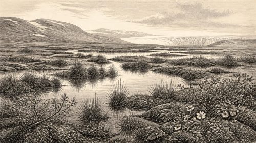
Modern dating places 31,817 BCE within a broad, uncertain Marine Isotope Stage 3 range, rather than a recoverable historical year. Deposits at Derryvree in Fermanagh show that parts of Ireland supported cold, treeless tundra, freshwater hollows and grazing fauna between glacial advances. Castlepook Cave, County Cork, preserves reindeer, mammoth, hyaena and other Ice Age remains, reflecting a wider north-west European ecology. A deep mark on a reindeer femur may be a stone-tool butchery cut, offering evidence of Upper Palaeolithic visitors. However, disturbance, dating limits and absent associated finds preclude claims for settlement, society or continuity. Later ice expansion erased evidence.

Dateline
The label 31,817 BCE is a modern chronological convenience, not a date that anybody in prehistoric Ireland could have recorded or recognised. There were no Irish calendars, written annals or named political communities from which a year-specific event can be recovered. At this depth in time, archaeology works with broad scientific ranges, not individual years. In conventional archaeological terms, this point falls around 33,800 calibrated years before present (cal BP, where “present” is AD 1950), during the later part of Marine Isotope Stage 3, a volatile phase of the last Ice Age.
Ireland’s evidence for this era is exceptionally slight, fragmented and often difficult to date. It consists principally of sediments trapped beneath later glacial deposits, bones preserved in caves, and the results of modern re-examination of old collections. These remains can illuminate an Ice Age environment and the movements of animals; they cannot responsibly furnish a story of an Irish people, ruler, battle or settlement in this particular year. The most important question is therefore not what happened in 31,817 BCE, but what sort of country Ireland was within the longer interval that includes it.
A Date Within a Range
Radiocarbon years are not identical to calendar years. The concentration of radiocarbon in the atmosphere has varied through time, so laboratory determinations must be calibrated against internationally revised curves. Uncertainty becomes substantial at around 34,000 years ago. A useful local comparison comes from Derryvree, near Maguiresbridge in County Fermanagh, where roadworks exposed freshwater silts and fine sands sandwiched between two distinct tills: deposits laid down by separate advances of ice. The organic material produced a conventional radiocarbon age of 30,500 years BP, with a large error margin.
Later calibration has placed that determination broadly between about 36,900 and 31,700 cal BP. Expressed in BCE notation, that is approximately the mid-35th to late-30th millennia BCE. The modern date 31,817 BCE falls within this broad interval, but Derryvree does not document a moment, a season or a human visit. It records organic material accumulating in freshwater conditions before a later ice advance buried the deposit. Its value is that it demonstrates ice-free ground and a functioning plant-and-animal community in north-central Ireland during part of this long cold phase.
Greenagho, also in Fermanagh, and deposits at Hollymount and Aghnadarragh provide related evidence for earlier and middle phases of the last glacial cycle. Their sequences show that Ireland’s Ice Age history was not a simple, uninterrupted blanket of ice. Ice expanded and retreated regionally; in intervening periods, exposed landscapes supported vegetation, ponds, insects and grazing animals. The precise timing, extent and correlation of individual ice advances remain matters of specialist research, so these sites should not be treated as proof that the whole island had the same conditions simultaneously.
Open Ground and Freshwater Hollows
The Derryvree fossils indicate an open, treeless tundra or tundra-like landscape under periglacial conditions. Pollen was dominated by herbaceous plants, while moss remains and insect evidence point to wet ground, shallow pools and sedge-rich vegetation. “Periglacial” does not necessarily mean that ice lay immediately overhead. It describes a very cold environment shaped by frost, seasonal thaw and sparse plant cover, often on the margins of glaciers or ice sheets. Dry slopes, exposed gravel and wind-blown sediment could have existed close to waterlogged hollows and marshy basins.
This was not the green, wooded Ireland familiar from later prehistory or modern memory. Trees were at best extremely limited. The evidence suggests a landscape in which grasses, sedges, dwarf shrubs, herbs and mosses were more significant than forest. Seasonal contrasts were probably severe, and the growing season short. Such country was capable of supporting animals adapted to cold, open habitats, yet its productivity was precarious. Small shifts in temperature, precipitation, snow cover or the proximity of ice could alter the amount of forage and the availability of sheltered ground.
Conditions were not identical from Cork to Fermanagh. Ireland’s relief, coasts and proximity to Atlantic waters would have created regional variation, while the archaeological record is itself uneven because later glaciers scoured away or buried so much of the older surface. The Derryvree deposits offer a detailed northern window; they are not a weather report for every valley on the island. Nevertheless, they make clear that parts of Ireland could sustain freshwater ecosystems during the broad period relevant to 31,817 BCE.
Caves and Ice-Age Fauna
Southern Irish caves provide another window, especially Castlepook Cave near Doneraile in north County Cork, also known as Mammoth Cave. Cave deposits and old museum collections from Castlepook have yielded a rich Pleistocene fauna including reindeer, brown bear, spotted hyaena, wolf or fox, hare and woolly mammoth remains. Modern radiocarbon reassessment has shown that some earlier determinations for southern Irish cave bones were too young, strengthening the case that several species were present in Ireland during Marine Isotope Stage 3, before the Last Glacial Maximum.
The animals should not be imagined as a neat herd assembled at one time or in one place. A cave is a complicated archive. Carnivores may drag carcass parts into it; animals can die in fissures; water and sediment move bones; later excavation can disturb their original positions. Spotted hyaena activity is particularly important, because dens can concentrate bones from animals killed or scavenged elsewhere. Cave fauna therefore reveal which species reached an area and what processes affected their remains, but seldom reconstruct a single living landscape without qualification.
Reindeer are especially evocative because they suit open, cold country and may have moved through Ireland as conditions allowed. Mammoth and hyaena remains indicate that the island formed part of a wider north-west European Ice Age ecological zone. Lower sea levels altered the outlines of surrounding seas and exposed areas now submerged on the Celtic and Irish Sea shelves. Yet no simple route across that changing world should be assumed: the accessibility of Ireland depended on sea level, coastlines, ice margins, rivers, vegetation and weather, all of which changed over millennia.
The Mark on the Femur
A reindeer femur from Castlepook has made this period particularly significant for Irish archaeology. County Cork heritage material identifies it as a Palaeolithic object dating to about 31,000 BCE and illustrates a deep mark interpreted by zooarchaeologist Ruth Carden as having been made with a sharp stone tool while the carcass was butchered. If that interpretation is upheld, it would provide a potentially very early indication of people handling an animal in Ireland, far earlier than the better-established terminal Palaeolithic evidence from Alice and Gwendoline Cave in County Clare.
That possibility deserves attention, but not exaggeration. The date is approximate rather than a calibrated date-range for a particular action. It dates the animal bone, not necessarily the instant at which a cut was made. Moreover, the specimen comes from a cave collection shaped by early twentieth-century excavation and a long history of natural disturbance. Identifying a surface mark as human-made is a specialised taphonomic judgement: it must be distinguished from carnivore damage, sediment abrasion, weathering, excavation damage and later handling.
No securely associated stone-tool assemblage, hearth, dwelling surface, human burial, cave art or substantial food-processing deposit of comparable age has yet been recovered in Ireland. The responsible conclusion is consequently modest. Castlepook may preserve evidence that one or more Upper Palaeolithic hunters processed reindeer on the island during a broad period around the early 30th millennium BCE. It does not demonstrate a permanent settlement, continuous population, named archaeological culture or direct ancestry linking such visitors to later communities.
No Polities or Proven Institutions
There is no evidence for Irish kingdoms, chiefs, tribal names, law, diplomacy or formal political institutions around 31,817 BCE. Nor can archaeology identify warfare on the island at this date. Hunters, carnivores and scavengers may all have competed for animals and shelter, but ecological competition is not evidence for organised conflict. A modified bone, even if genuinely cut by a person, cannot reveal the size of a group, its language, kinship system or relations with groups elsewhere.
Religion, art and learning are equally beyond direct recovery in Ireland for this period. Upper Palaeolithic communities elsewhere in Europe made elaborate tools, ornaments, images and ceremonial deposits, demonstrating formidable practical knowledge and cultural capacity. That wider context makes a human visit to Ireland conceivable, but it cannot be used to assign continental artistic styles, beliefs or rituals to Castlepook without Irish finds. Absence of evidence is not proof that visitors lacked custom or imagination; it is a boundary on what the surviving record can show.
There is likewise no demonstrable Irish economy of farming, exchange or long-distance trade. If people did enter the island, their subsistence may have involved the opportunistic hunting or processing of large game, perhaps alongside gathering and other activities invisible in the record. Such a proposition remains interpretation, not a documented economy. There were no known fields, domestic animals, villages, ports or monuments. The practical realities of movement, finding shelter, preserving food and following animal routes would have mattered far more than institutions that belong to much later human history.
Approaching Greater Ice
In the long term, this was a landscape heading towards dramatic regional change. The Last Glacial Maximum came later, broadly between about 26,500 and 19,000 years ago, when the British-Irish Ice Sheet reached a much greater extent. Research indicates that ice growth was asynchronous: different sectors advanced at different times and rates. By the maximum, ice had remodelled much of Ireland’s lowland surface and extended onto adjacent continental shelves. That later expansion buried, eroded and redistributed older deposits, helping to explain why evidence for this earlier interval is so scarce.
For Ireland around 31,817 BCE, the central historical picture is therefore one of open cold country, freshwater pockets, mobile fauna and profound uncertainty. Derryvree supplies firm environmental evidence for an ice-free periglacial episode within the relevant chronological range. Castlepook supplies a remarkable faunal archive and a potentially transformative, but still limited, sign of human butchery. Together they reveal not an ancient nation in formation, but an intermittently habitable edge of Ice Age north-west Europe whose earliest human traces may survive only in a single line cut into bone.
Primary Sources
- Middle Midlandian Freshwater Series at Derryvree, Maguiresbridge, County Fermanagh, Northern Ireland
- Middle Midlandian Interstadial Deposits at Greenagho, Near Belcoo, County Fermanagh, Northern Ireland
- A Reconsideration of the Radiocarbon Dating of the Marine Isotope Stage 3 Fauna from Southern Ireland
- The Irish Quaternary Fauna Project
- Red Deer in Early Postglacial Ireland: A Review of Recent Zooarchaeological and Palaeoecological Evidence
- Trimlines, Blockfields and the Vertical Extent of the Last Ice Sheet in Southern Ireland
- Extent and Timing of the Last Glacial Maximum (LGM) in Britain and Ireland: A Review
- Late Pleistocene Chronostratigraphy and Ice Sheet Limits, Southern Ireland
- Growth and Retreat of the Last British–Irish Ice Sheet, 31,000 to 15,000 Years Ago: The BRITICE-CHRONO Reconstruction
- Advance and Retreat of the Marine-Terminating Irish Sea Ice Stream into the Celtic Sea During the Last Glacial: Timing and Maximum Extent
- Deglaciation Chronology of the Donegal Ice Centre, North-West Ireland
- Pattern and Timing of Retreat of the Last British-Irish Ice Sheet
- Growth and Decay of a Marine Terminating Sector of the Last British-Irish Ice Sheet: A Geomorphological Reconstruction
- Dimensions and Chronology of the Last Ice Sheet in Western Ireland
- Figure 6: The Subdivision of the Quaternary Period in Ireland
- Palaeoecology
- The IntCal20 Northern Hemisphere Radiocarbon Age Calibration Curve (0–55 cal kBP)
- First Evidence of a Late Upper Palaeolithic Human Presence in Ireland
- Heritage Artefacts of County Cork
- 2022:564 – Castlepook Cave, Castlepook South, Cork
- Archaeology Research Excavation Grant 2022