
Derryvree’s Buried Sedge Margin30419 BCE
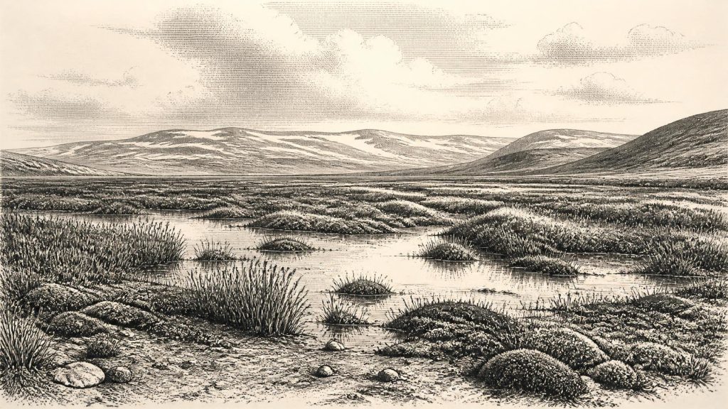
Around 30,419 BCE, Ireland’s record is environmental, not historical. At Derryvree, County Fermanagh, freshwater silts containing wetland plants and animals lie between glacial tills. Radiocarbon dating and calibration place this deposit broadly within later Marine Isotope Stage 3, although not at a precise year. It demonstrates a cold, treeless, periglacial wetland between ice advances, challenging notions of continuous ice cover. Cave faunas indicate intermittent cold-adapted mammals, but cannot reconstruct a single contemporary community. No secure evidence establishes human occupation then; later finds and disputed marks offer only limited possibilities. Derryvree preserves a local archive of climatic instability and glacial change.
Dateline
30,419 BCE is a modern chronological label, not a year that can be recovered from Irish prehistory. No inhabitants of Ireland left a calendar, name, settlement plan or event record that can be assigned to it. In archaeological terms, the point lies roughly 32,400 calibrated years before AD 1950, within Marine Isotope Stage 3 of the last Ice Age. The responsible history of Ireland at this horizon is therefore environmental and archaeological rather than political: it concerns ice, water, plants, animals and the limits of what the surviving evidence can say about people.
The closest important Irish archive is at Derryvree, near Maguiresbridge in County Fermanagh. Road works in 1969 cut through a drumlin and exposed a remarkable sequence: thick glacial till below, freshwater silts and fine sands with organic material in the middle, and another thick till above. The intervening deposit was dated to 30,500 radiocarbon years BP, with a substantial uncertainty range (Birm-166). Calibration converts a radiocarbon determination into a wider calendar-age probability range; published treatments place this Derryvree interval broadly in the later part of MIS 3, approximately 36,900–31,700 calibrated years BP. Thus 30,419 BCE falls near the younger end of the broad window that the deposit can illuminate, not at a precisely dated moment within it.
A Wetland Between Ice Advances
Derryvree offers unusually direct evidence that this part of Ireland was, at least for a time, not continuously buried beneath ice. The organic silts were laid down in freshwater conditions between episodes that deposited glacier-borne debris. Their plant and animal remains indicate open tundra and a periglacial regime: ground subject to intense frost, seasonal thaw and cold-water sediment movement. This was not a forested Ireland, nor a benign “warm interval” in a modern sense. It was a severe, treeless landscape in which pools, wet hollows and sedge- and moss-rich ground could nevertheless sustain a specialised living community.
The small fossils are more informative than any imagined panorama. Water plants, wetland mosses, sedges and arctic-alpine taxa show that fresh water persisted locally during at least part of the year. Their presence points to a varied terrain rather than a featureless snow desert: shallow water, saturated margins, mineral-rich silts and exposed ground existed beside one another. Such environments could change rapidly with season, meltwater supply and the proximity of ice. The Derryvree deposit is consequently a local record, not a map of every Irish valley or coast. It does, however, decisively complicate the older assumption that the island was uniformly ice-covered throughout the latter part of the last glaciation.
Climate across the North Atlantic at this time was unstable on scales much longer than a human lifetime but very short in geological terms. Greenland ice-core records preserve repeated abrupt shifts between colder stadial conditions and relatively milder interstadials. Derryvree cannot securely be tied to a single named Greenland event simply by translating the modern year 30,419 BCE into a number. Its conventional radiocarbon age, calibration uncertainty and the duration of sediment accumulation do not permit that degree of precision. What can be said is that the deposit belongs to an era when cold, open environments and shifting ice margins repeatedly transformed north-west Europe.
The Gathering Ice
Ireland stood on the threshold of much greater glaciation. The fullest expansion of the British–Irish Ice Sheet came later, principally during the Last Glacial Maximum, but the ice system did not appear everywhere at once. Modern reconstructions begin their detailed mapping only around 31,000 years ago because earlier constraints are sparse. They infer growing ice centres over northern Ireland and upland areas, followed by rapid expansion and coalescence. That chronology is close enough to make the future threat to Derryvree clear, but not close enough to claim that a particular glacier occupied Fermanagh in 30,419 BCE.
The stratigraphy tells the larger story plainly. First ice deposited the lower till. Then conditions allowed a freshwater basin and tundra wetland to develop. Later ice overwhelmed and sealed the deposit beneath the upper till, contributing to the drumlin landscape eventually exposed by the road cut. A buried wetland is therefore not evidence of gradual climatic improvement; it is evidence of interruption in a longer cycle of glacial change. Ireland’s physical regions were being repeatedly reordered by erosion, sediment transport, frozen ground and ice movement long before any later human landscape, field system or place-name existed.
Animals at the Western Margin
Caves and fissures, especially Castlepook Cave near Doneraile in County Cork, add a wider but less tightly resolved picture of Irish life during the last Ice Age. Collections from Irish cave sites have produced remains attributed to woolly mammoth, reindeer, giant deer, brown bear, wolf, Arctic fox, mountain hare, lemmings and spotted hyaena. The Irish Quaternary Fauna Project showed that a range of mammals entered Ireland between at least about 45,000 and 20,000 years ago. Their presence demonstrates that Ireland participated in wider north-west European ecological networks during intervals of low sea level and altered coastlines.
Yet these faunal lists must not be turned into a single, crowded scene for 30,419 BCE. Cave deposits can combine remains accumulated over many millennia; some early excavations disturbed their original layers; and direct dates have revised earlier conclusions. A mammoth bone, a hyaena tooth and a reindeer antler from one cave do not prove that all three animals met there in the same season. At most, the evidence supports a broad interpretation: open, cold-country habitats were intermittently available in Ireland, and large herbivores and predators could reach and use them. It does not establish fixed migration routes, population sizes, hunting territories or an unbroken animal community.
People: An Unanswered Question
There is no securely dated house, hearth, stone-tool assemblage, burial or occupation surface in Ireland from around 30,419 BCE. Accordingly, no responsible account can identify a community, language, kinship system, leader or cultural tradition for this year. The earliest well-published direct evidence of human activity currently accepted in Ireland is much later: cut marks on a brown-bear patella from Alice and Gwendoline Cave, County Clare, radiocarbon dated to about 12,810–12,590 calibrated years BP. That terminal-Pleistocene find records a small-scale human incursion, not the beginning of a continuous documented population.
A reindeer femur from Castlepook has been presented by Ruth Carden and Cork heritage publications as bearing a deep mark consistent with stone-tool butchery, raising the possibility of a far earlier Upper Palaeolithic human presence. It is an important lead, especially because it concerns a cave fauna broadly relevant to the period under discussion. But the evidence has not yielded an excavated settlement or a securely published, year-level human chronology. It should be treated as a proposition requiring continued specialist study, not as a licence to populate Derryvree with hunters, camps or rituals.
No Politics, Trade or Religion in View
For this date, political affairs, diplomacy and warfare are beyond the evidence. There are no polities to trace, no monuments, weapons, meeting places or territorial boundaries. Nor can trade be demonstrated: no imported raw material, manufactured object or exchange network has been securely connected to Ireland at this horizon. If people entered the island intermittently, they would have lived in a landscape of formidable climatic risk and changing access routes; that is an inference from the environment, not proof of a particular voyage, economy or social organisation.
The same restraint applies to religion, art and learning. European Upper Palaeolithic peoples elsewhere made sophisticated tools and images, but Irish evidence does not show that such practices occurred here around 30,419 BCE. It is not valid to borrow cave art, beliefs or customs from France, Iberia or Britain and present them as Irish history. The culture recoverable from Derryvree is the culture of evidence itself: pollen and plant macrofossils, insect and animal remains, layered silts, radiocarbon measurement and calibration, all read against the physical record of ice.
What matters most is not a lost episode of Irish kingship or settlement, but the survival of a narrow environmental archive. At Derryvree, plants rooted by cold freshwater while glaciers had either retreated from, or had not yet reached, this part of Fermanagh. Before and after, ice laid down the tills that enclosed their remains. Around 30,419 BCE, Ireland was an unstable western refuge and corridor for cold-adapted life, not a documented human homeland. That distinction between evidence and possibility is the essential fact of the year.
Primary Sources
- A Middle Midlandian Freshwater Series at Derryvree, Maguiresbridge, County Fermanagh, Northern Ireland
- The Irish Quaternary Fauna Project
- Irish Pleistocene Biostratigraphy
- Pleistocene Glaciations in Ireland
- The Geology of Ireland: Cenozoic, Tertiary and Quaternary
- Growth and Retreat of the Last British–Irish Ice Sheet, 31,000 to 15,000 Years Ago: the BRITICE-CHRONO Reconstruction
- Deglaciation Chronology of the Donegal Ice Centre, North-West Ireland
- Trimlines, Blockfields and the Vertical Extent of the Last Ice Sheet in Southern Ireland
- Radiocarbon Constraints on the Age of the Maximum Advance of the British–Irish Ice Sheet in the Celtic Sea
- Growth, Dynamics and Deglaciation of the Last British–Irish Ice Sheet: the Deep-Sea Ice-Rafted Detritus Record
- Response of the Irish Ice Sheet to Abrupt Climate Change During the Last Deglaciation
- The IntCal20 Northern Hemisphere Radiocarbon Age Calibration Curve (0–55 cal kBP)
- Marine20—The Marine Radiocarbon Age Calibration Curve (0–55,000 cal BP)
- First Evidence of a Late Upper Palaeolithic Human Presence in Ireland
- New Insights on the Fauna of Ireland’s Younger Dryas and Early Holocene from Alice & Gwendoline Cave
- The Colonization of Ireland: A Human Ecology Perspective
- Our Ancient Landscapes: Hunter-Gatherers in Ireland
- Archaeological Heritage of County Cork
- Heritage Artefacts of County Cork
- The Subdivision of the Quaternary Period in Ireland
- Advance and Retreat of the Marine-Terminating Irish Sea Ice Stream into the Celtic Sea During the Last Glacial: Timing and Maximum Extent
- Maximum Extent and Readvance Dynamics of the Irish Sea Ice Stream and Irish Sea Glacier Since the Last Glacial Maximum
