

Derryvree’s Hidden Silt31686 BCE
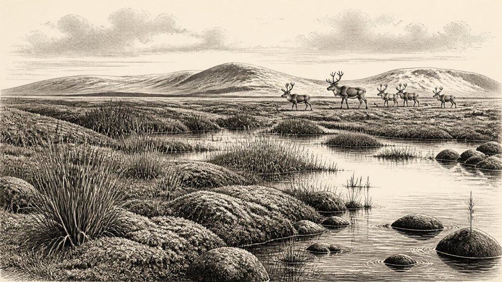
About 31,686 BCE, Ireland lay in the fluctuating cold conditions of Marine Isotope Stage 3, though no evidence can date events to that single year. At Derryvree, County Fermanagh, freshwater sediments between glacial tills record a treeless, wet-tundra environment during an interval between ice advances. Castlepook Cave, County Cork, preserves MIS 3 remains of reindeer, bear, arctic fox, hare, hyaena, giant deer and mammoth, demonstrating episodic ecological links with north-west Europe. Possible human modification of a reindeer bone remains unconfirmed and cannot prove settlement. The evidence instead reveals shifting ice, wetlands, open vegetation and mobile fauna, while interpretations remain provisional.
Dateline
The label 31,686 BCE is a modern way of locating a point deep in prehistory, not a year that anyone then named, recorded or experienced in a calendar. In radiocarbon terms it corresponds broadly to about 33,636 years before AD 1950, but that apparent precision is misleading. No Irish deposit can presently be assigned securely to this individual year. The responsible approach is to place it within wider calibrated ranges and to ask what those ranges reveal. Around this point Ireland lay in the later part of Marine Isotope Stage 3, a fluctuating cold phase of the Late Pleistocene, several millennia before the Last Glacial Maximum overwhelmed much of the island.
A Date Inside Broad Ranges
The most useful Irish environmental sequence for this broad interval is at Derryvree near Maguiresbridge, County Fermanagh. Roadworks exposed freshwater silts and sands sealed between two layers of glacial till: evidence first of ice, then of a period in which water and sediments accumulated in an ice-free or locally ice-marginal landscape, and finally of renewed glaciation. Organic material from the freshwater beds returned a radiocarbon age of about 30,500 radiocarbon years before present. Calibration gives a much wider calendar range, approximately 36,900–31,700 calibrated years BP. The modern label 31,686 BCE falls within that span, but close enough neither to its beginning nor end to justify treating Derryvree as a snapshot of one year.
The sequence nevertheless establishes an important point. At some time during later MIS 3, northern Ireland contained a freshwater, periglacial environment before a subsequent ice advance buried it. Pollen, plant macrofossils and sediment character indicate a largely treeless landscape, often described as muskeg or wet tundra: saturated ground with sedges, mosses and cold-adapted plants, broken by pools and sluggish watercourses. This was not the familiar green, wooded Ireland of later millennia. Nor should evidence from one Fermanagh basin be converted into a uniform island-wide weather report. It is a local archive, although one with major significance for understanding regional conditions.
Cold Ground, Living Water
At this date Ireland was not yet simply an island entombed beneath the maximum extent of the last ice sheet. Climate and ice limits shifted repeatedly over long timescales. The later Last Glacial Maximum is generally placed at about 26,500–19,000 years ago globally, while the British–Irish Ice Sheet had its own changing margins, flow patterns and local timings. Around the period represented at Derryvree, cold conditions, exposed ground, seasonal freeze-thaw and expanding ice were fundamental facts of life, but they did not eliminate every wetland, cave refuge or animal corridor. The order of the Derryvree deposits itself records this instability: ice, freshwater deposition, then ice again.
Such an environment would have been highly seasonal. Open ground could support herbaceous vegetation during the short growing season, while winter frost affected soils, drainage and movement. The evidence does not permit estimates of a precise temperature for 31,686 BCE, nor does it show whether every valley was equally harsh. It does show that Ireland’s Pleistocene environments repeatedly altered as climate oscillated. Rivers and shallow pools could be productive places for plants, insects, birds and mammals, even amid extensive cold-steppe or tundra vegetation. These ecological patches mattered because they helped sustain animal populations at Europe’s north-western edge.
The Castlepook Fauna
In north County Cork, Castlepook Cave near Doneraile provides the other essential Irish line of evidence. Excavations beginning in the early twentieth century recovered a remarkable quantity of animal bone from its passages and chambers. Later reappraisal and radiocarbon dating have shown that at least part of the assemblage belongs to MIS 3, broadly before the Last Glacial Maximum. Its fauna includes reindeer, brown bear, arctic fox, hare, spotted hyaena, giant deer and woolly mammoth. Not every specimen belongs to the same moment, and the cave’s deposits were disturbed by both ancient processes and older excavation. Yet together they demonstrate that Ireland periodically supported, or was reached by, a far richer large-mammal fauna than survives in its later prehistoric record.
For a date around 31,686 BCE, Castlepook should therefore be understood first as a faunal and palaeoenvironmental archive. Reindeer suggest open, cold-country grazing habitat. Hyaenas, where their remains genuinely represent occupation or denning rather than material moved by other agencies, point to a carnivore community capable of exploiting large carcasses. Mammoth and giant deer bones indicate the presence of animals associated with extensive, open Pleistocene landscapes. Cave bones do not automatically reveal a harmonious local herd living beside the entrance. They may represent animals dying at different times, remains dragged in by carnivores, natural deaths, water movement or material reworked within the cave system.
This qualification matters especially because older cave excavations commonly removed deposits before modern stratigraphic recording, sieving and dating methods existed. The original Castlepook investigations were invaluable in preserving finds, many now associated with the National Museum of Ireland, but they did not leave the kind of intact sequence archaeologists would now seek. Recent licensed work at Castlepook has attempted to identify surviving undisturbed deposits and to improve the chronology. New dates and new sediment studies may therefore alter the story. The strongest conclusion at present is not that every listed animal shared a single landscape, but that late-Pleistocene Ireland had episodic ecological connections sufficient for a varied fauna to occur.
The Human Question
Human presence at this early date remains a question rather than an established narrative. A reindeer femur from Castlepook has been interpreted as bearing a deep modification made on fresh bone with a stone edge, possibly during carcass processing. If that interpretation is confirmed, and if the modification is securely contemporary with the animal’s death, it would be evidence that Upper Palaeolithic people reached Ireland around this broad period. It would be an important extension of Ireland’s human story. It is not, however, evidence for a permanent settlement, a resident population, a named people or a continuous occupation of the island.
The distinction is crucial. There is no securely dated house, hearth, lithic workshop, human burial, food refuse deposit or substantial tool assemblage in Ireland that can be assigned to around 31,686 BCE. The more firmly published evidence for a human visit is much later: cut marks on a brown-bear kneecap from Alice and Gwendoline Cave in County Clare, directly dated to calibrated ranges of about 12,810–12,590 and 12,730–12,685 cal BP. That find shows how a single modified bone can provide meaningful evidence of an encounter, while still leaving much unknown about duration, group size and wider settlement.
Accordingly, no political affairs, diplomacy or warfare can responsibly be narrated for Ireland at this date. There were no written polities, rulers, borders or institutions known to the evidence. Nor can archaeology identify a religion, language, artistic tradition or system of formal learning in Ireland from this point. Upper Palaeolithic communities elsewhere in Europe made sophisticated stone technologies, ornaments and cave art, but it would be unsound to transfer those practices automatically across the Irish Sea. A possible cut-marked bone could indicate the practical use of a sharp stone tool; it cannot establish an Irish cultural tradition.
Mobility Without a Map
If people did reach the island during MIS 3, their presence was probably brief and mobile. A party capable of reaching a cold, sparsely wooded western landscape would have required knowledge of animals, weather, clothing, fire and stone-working. But this is an inference from the logistical demands of Upper Palaeolithic life elsewhere, not direct evidence for a camp at Castlepook. The landscape itself was different: lower sea levels altered coastlines and the configuration of surrounding shelves, while glacial advances and retreats repeatedly changed possible routes. Faunal evidence indicates connection with wider north-west European ecosystems, but it cannot specify whether animals or people moved over exposed land, across seasonal ice, by short water crossings, or through changing combinations of these routes.
Nor is there evidence for trade in the ordinary historical sense. A visitor who butchered a reindeer, if that is what the Castlepook mark represents, would have pursued immediate subsistence: meat, fat, hide, sinew and perhaps bone. Such resources are plausible products of a carcass, not recovered commodities. We cannot identify exchange networks, camps linked by regular travel, or social territories. The cave record speaks far more clearly of animal life and depositional processes than of human economy.
What This Year Can Mean
The lasting importance of 31,686 BCE lies not in an invented event but in Ireland’s position at a climatic threshold. Derryvree preserves the signature of cold freshwater wetlands between glacial episodes. Castlepook preserves the bones of animals that make later Ireland seem biologically impoverished by comparison. Together they show a changing Pleistocene country in which ice, water, open vegetation and mobile fauna continually reshaped the possibilities for life.
For Ireland, this is an age of evidence fragments rather than biography. The securely observable facts are sediments, pollen, plant remains, bones, cave contexts and radiocarbon ranges. Interpretations—whether a specific bone was cut by a person, how animals reached the region, or how habitable particular seasons were—must remain visibly provisional. That restraint is not a failure of history. It is the appropriate way to recover the deep past: allowing Derryvree’s hidden silt and Castlepook’s bones to tell us what they can, without making them claim more than they preserve.
Primary Sources
- A Middle Midlandian Freshwater Series at Derryvree, Maguiresbridge, County Fermanagh, Northern Ireland
- The Irish Quaternary Fauna Project
- A Reconsideration of the Radiocarbon Dating of the Marine Isotope Stage 3 Fauna from Southern Ireland
- The Exploration of Castlepook Cave, Co. Cork. With 3 Plates
- First Evidence of a Late Upper Palaeolithic Human Presence in Ireland
- New Insights on the Fauna of Ireland's Younger Dryas and Early Holocene from Alice & Gwendoline Cave
- Figure 6: The Subdivision of the Quaternary Period in Ireland
- Trimlines, Blockfields and the Vertical Extent of the Last Ice Sheet in Southern Ireland
- Dimensions and Chronology of the Last Ice Sheet in Western Ireland
- Radiocarbon Constraints on the Age of the Maximum Advance of the British–Irish Ice Sheet in the Celtic Sea
- Timing and Pace of Ice-Sheet Withdrawal Across the Marine–Terrestrial Transition West of Ireland During the Last Glaciation
- Response of the Irish Ice Sheet to Abrupt Climate Change During the Last Deglaciation
- The Last Glacial Maximum
- Prehistoric Details
- 2022:564 – Castlepook Cave, Castlepook South, Cork
- Archaeological Heritage of County Cork
- The Mesolithic in Ireland: When Was It?
- Archaeology
- Atlas of the Irish Rural Landscape: Early Prehistory
- Sedimentary Ancient DNA Reveals Late Pleistocene Faunal Connectivity Between Ireland and Eurasia