
Juniper Below the Drumlin31551 BCE
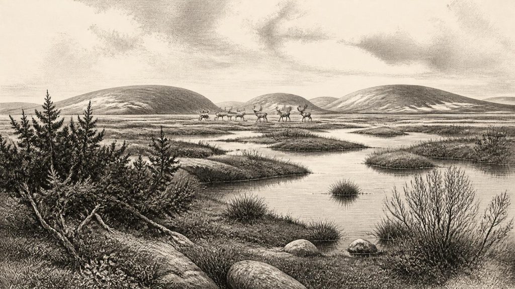
31,551 BCE represents a broad later Middle Midlandian, Marine Isotope Stage 3 interval, rather than a dateable Irish year. At Derryvree, County Fermanagh, freshwater organic sediments between glacial tills indicate a locally ice-free cold phase, broadly dated 36,900–31,700 calibrated years BP. Pollen and plant remains describe treeless, wet, frost-affected terrain with grasses, sedges, juniper and arctic-alpine flora. Southern cave faunas include reindeer, mammoth, giant deer, bear, fox and hyaena, but their associations remain uncertain. A possibly cut-marked reindeer femur from Castlepook suggests a provisional early human visit, not settlement. Glacial erosion, inundation and poor preservation limit reconstruction of Ice-Age Ireland.
Dateline
The label 31,551 BCE cannot identify a particular Irish event, ruler, battle or season. It is a modern calendar rendering for a point roughly 33,500 years before AD 1950, the conventional reference date used in archaeological “before present” chronology. No written record, annual sequence of settlements or archaeological layer can be resolved to that precision in Ice-Age Ireland. The responsible frame is therefore a broad interval in the later Middle Midlandian cold stage, generally correlated with Marine Isotope Stage 3, rather than a purported year in a prehistoric calendar.
Even that broad setting requires care. Radiocarbon ages are not identical to calendar ages: they must be calibrated against changing atmospheric carbon levels, and measurements this old commonly translate into probability ranges spanning centuries or millennia. Ireland’s best environmental evidence relevant to this horizon comes from deposits and cave faunas whose dates overlap it broadly, not exactly. They show a cold, dynamic and regionally varied land at the north-western edge of Europe—one that was not the familiar wooded island of later prehistory, but was not necessarily covered everywhere by permanent ice either.
Evidence Between Two Glaciations
The most informative Irish site is Derryvree, near Maguiresbridge in County Fermanagh. Road-cutting through a drumlin in 1969 exposed a remarkable succession: a freshwater bed of silts, fine sand and organic material lay between two thick layers of till, sediment deposited directly by glacier ice. Its position records an important sequence. Ice had affected the locality; then, for a substantial period, open water and wetland sediments accumulated in an ice-free landscape; finally, a later advance of ice sealed the deposit beneath fresh till. The survival of such a fragile organic layer beneath a drumlin is exceptional.
Organic material from Derryvree produced a conventional radiocarbon determination of 30,500 +1,170/−1,030 radiocarbon years BP. Under modern calibration, the relevant probability span is commonly placed broadly around 36,900–31,700 calibrated years BP. The nominal date of 31,551 BCE, approximately 33,500 years BP, falls within that wide interval. This does not mean that the exposed bed was laid down in 31,551 BCE, or that all Ireland shared its conditions at that moment. It means that Derryvree offers the closest securely dated Irish window on an environmental world that could have existed around the requested date.
The deposits are usually assigned to the Derryvree cold phase, a local term within Ireland’s Midlandian glacial history. Older accounts sometimes used “interstadial”, implying a milder interruption in glaciation. Later syntheses prefer the more cautious phrase “cold phase”, because the fossil evidence does not demonstrate a fully temperate interval. That distinction matters. Derryvree shows that glaciers were absent locally while freshwater and vegetation persisted; it does not show that Fermanagh had become warm, forested or climatically stable.
A Wet, Treeless Country
Pollen, plant macrofossils and moss remains make Derryvree more than a geological curiosity. They reveal a largely treeless, open landscape shaped by severe frost, short growing seasons and wet ground. Grasses and sedges were prominent. Juniper and other low shrubs occurred, while herbs and arctic-alpine plants included mountain avens, dwarf willow, crowberry, bogbean and alpine clubmoss. The associated moss flora points to damp hollows, pools and waterlogged ground. “Muskeg”, an older term used by the original investigators, usefully conveys a mossy, saturated mosaic rather than a smooth, dry steppe.
These remains are evidence for plants near the former waterbody, but they must not be converted into a photographic reconstruction of the whole island. Pollen may travel far, be redeposited from older sediments or survive unevenly; a few grains of pine or hazel do not establish local woodland. The combined signal, however, is clear enough: mature forest was absent around Derryvree, and dry land was probably sparse in vegetation. A visitor would have encountered low growth, exposed mineral ground, shallow water and frost-disturbed soils, with seasonal bursts of life wherever moisture and summer light allowed plants to flourish.
This was an environment in which climate had direct practical force. Repeated freezing and thawing could fracture rock, churn soil and alter drainage. Snow cover, wind exposure and frozen ground would have varied sharply by season and topography. Valleys, lake margins and sheltered limestone country may have offered relatively favourable patches; uplands and exposed plateaux would have been harsher. It is safer to picture a patchwork of opportunities and constraints than one uniform “Ice-Age Ireland”.
Caves and Ice-Age Animals
Cave collections from southern Ireland add an animal dimension. Castlepook Cave near Doneraile, County Cork—long known as Mammoth Cave—has produced remains attributed to woolly mammoth, reindeer, giant deer, brown bear, hare, fox and spotted hyaena. Modern re-dating has shown that several of the older cave collections are substantially older than early radiocarbon determinations suggested. Some of the Castlepook material belongs to Marine Isotope Stage 3, and work on Irish cave faunas indicates that certain large mammals, notably giant deer and spotted hyaena, may have disappeared locally before the Last Glacial Maximum.
The cave bones demonstrate that animals moved through, lived in or were carried into parts of Ireland during cold phases of the later Pleistocene. They do not demonstrate that every species stood together in one herd, nor that every cave chamber was a human hunting camp. Carnivores could drag carcass parts into dens; water, gravity and nineteenth- or early twentieth-century excavation methods could mix deposits. Castlepook is especially valuable precisely because its rich old collection is now being reassessed alongside efforts to locate undisturbed Pleistocene sediments in the cave system.
Reindeer are particularly relevant to the Derryvree-type setting. Their presence is consistent with open, cold country and seasonal mobility, although bones alone cannot map annual migrations. Mammoth, giant deer and hyaena evoke the wider mammoth-steppe and tundra mosaic of north-western Europe, but Irish evidence is too fragmentary to calculate herd sizes or predator numbers. The important conclusion is modest: Ireland contained habitats capable of supporting a cold-adapted fauna during parts of this long interval.
The Reindeer Femur Question
One Castlepook find gives this period unusual archaeological importance. A reindeer femur from the old cave collection has been reported as bearing a deep incision which zooarchaeologist Ruth Carden has interpreted as a mark made with a sharp stone tool during carcass processing. County Cork heritage material has presented it as roughly 31,000 BCE. If that interpretation and association are confirmed, the bone would be potential evidence that Upper Palaeolithic people reached Ireland far earlier than the well-established post-glacial settlement record.
Its limits must be stated equally plainly. A radiocarbon result dates the death of the animal, not automatically the making of a mark. The diagnosis of a cut mark is a specialist taphonomic judgement, distinct from the laboratory measurement. Moreover, the femur derives from an old collection without a securely excavated occupation surface containing tools, hearths and food debris together. No lithic assemblage, dwelling, burial, art, hearth or human bone has yet demonstrated a resident Irish community at this date. The find supports a serious research question about a possible brief human visit; it does not establish continuous occupation, a named population or ancestry connecting any visitors to later Irish people.
People Beyond the Sea
At roughly 33,500 years ago, anatomically modern humans were established elsewhere in Europe and Upper Palaeolithic groups possessed sophisticated knowledge of animal behaviour, stone-working and seasonal movement. Lower sea levels altered the geography of the north-west European shelf, but Ireland was still separated from Britain by sea. Any crossing therefore required watercraft or sea travel, not merely a walk across a dry land bridge. Whether people made such journeys at this particular Irish horizon remains unproved.
If small groups did enter Ireland, the most defensible interpretation is of mobile foragers, perhaps following animal resources and operating within wider networks beyond the island. They would have needed practical knowledge of shelter, fire, clothing, food storage and movement through a demanding landscape. Those requirements are reasonable inferences from Upper Palaeolithic life elsewhere, not direct evidence from an Irish camp. There is no basis for describing tribes, language, leaders, alliances, warfare or diplomacy. Nor is there evidence for permanent villages, farming, trade routes, ritual monuments, formal religion, writing or learning institutions.
Silence as Historical Evidence
The absence of those things is not simply an absence of imagination. Later ice advances eroded landscapes, redeposited sediment and destroyed many surfaces on which camps might once have stood. Rising seas later inundated extensive shelf landscapes, while acidic soils and poor preservation eliminate much organic evidence. Caves and sealed wetland deposits survive disproportionately, so the archaeological record is tilted towards animal bone and environmental traces. A single marked bone may matter greatly, but it cannot bear the weight of a complete national narrative.
For Ireland around 31,551 BCE, then, the principal history is environmental: a fluctuating North Atlantic cold phase; treeless, frost-affected wetlands at Derryvree; and a fauna including reindeer and other large mammals in suitable habitats. The possibility of a human encounter at Castlepook is consequential but remains provisional. What can be said with confidence is that this was neither an empty calendar year nor a recoverable chapter of kings and settlements. It was a broad and unstable Ice-Age interval, preserved in silts, pollen, mosses and bone, from which archaeology can reconstruct conditions—but not invent certainties.
Primary Sources
- A Middle Midlandian Freshwater Series at Derryvree, Maguiresbridge, County Fermanagh, Northern Ireland
- Quaternary Deposits and Glacial Stratigraphy in Ireland
- Landscapes and Environments of the Last Glacial-Interglacial Transition: A Time of Amazingly Rapid Change in Ireland
- Irish Pleistocene Biostratigraphy
- A Reconsideration of the Radiocarbon Dating of the Marine Isotope Stage 3 Fauna from Southern Ireland
- New Insights on the Fauna of Ireland's Younger Dryas and Early Holocene from Alice & Gwendoline Cave
- First Evidence of a Late Upper Palaeolithic Human Presence in Ireland
- The Irish Quaternary Fauna Project
- The Brown Bear (Ursus arctos L.) in Ireland
- Quaternary Science Reviews 42 (2012) 74–84
- Palaeoecology
- Dryas octopetala
- The IntCal20 Northern Hemisphere Radiocarbon Age Calibration Curve (0–55 cal kBP)
- The IntCal20 Northern Hemisphere Radiocarbon Age Calibration Curve (0–55 cal kBP)
- Response of the Irish Ice Sheet to Abrupt Climate Change During the Last Deglaciation
- Oscillating Retreat of the Last British-Irish Ice Sheet on the Continental Shelf Offshore Galway Bay, Western Ireland
- The Deglaciation of the Western Sector of the Irish Ice Sheet from the Inner Continental Shelf to its Terrestrial Margin
- The Evolution of the Terrestrial-Terminating Irish Sea Glacier During the Last Glaciation
- A Critical Review and Re-Investigation of the Pleistocene Deposits
- Geomorphic Evidence for Patterns of Late Midlandian Ice Advance and Retreat in the Omagh Basin
- Cenozoic: Tertiary and Quaternary
- Field Guides
- Heritage Artefacts of County Cork