
Derryvree’s Moss-and-Sedge Flora31552 BCE
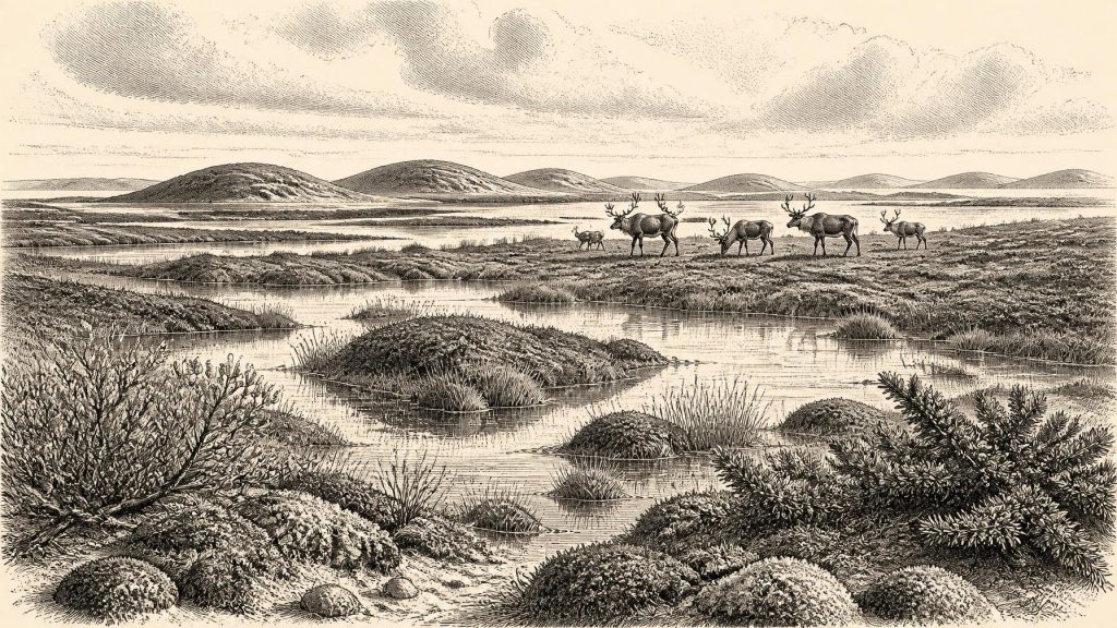
Around 31,552 BCE, Ireland has no recoverable yearly history; evidence instead describes a fluctuating Late Pleistocene environment. At Derryvree, County Fermanagh, freshwater sediments between glacial tills preserve a treeless tundra wetland of sedges, grasses, mosses, bogbean, juniper and sparse herbs, formed during an interval between ice advances. Castlepook Cave, County Cork, contains MIS 3 remains of mammoth, reindeer and other open-country, cold-adapted animals, although its deposits are mixed. A marked reindeer femur may indicate Upper Palaeolithic butchery, but cannot prove occupation. The evidence shows changing ice, wetlands and fauna, not settled communities, politics, farming or identifiable peoples for this date.
Dateline
Modern calendar-year precision is not available for Ireland in 31,552 BCE. No written calendar, settlement sequence or event horizon can identify anything that happened in that particular year. The date is best treated as a convenient point within the Late Pleistocene, broadly Marine Isotope Stage 3, about 33,500 calendar years before AD 1950. Evidence nearest to it comes not from a historical record but from buried sediments, animal bones and the changing state of the ice sheet. It can illuminate environments and possibilities; it cannot supply a king, a battle, a treaty, a village or a named people.
The strongest Irish environmental evidence is the Derryvree deposit near Maguiresbridge, County Fermanagh. Discovered in a road cutting through a drumlin in 1969, its freshwater silts and fine sands lay between two tills: deposits left by successive glacier advances. Organic material from this intervening bed returned a conventional radiocarbon determination of 30,500 ± 1,170 years BP. Calibrated ranges are necessarily broad at this depth of time; modern discussion places the deposit roughly within 36,900–31,700 calibrated years BP, or about 34,950–29,750 BCE. Thus 31,552 BCE falls within the range that the Derryvree evidence can responsibly help to describe, rather than marking a discernible moment in it.
A Wetland Between Glaciers
Derryvree is valuable because its position records sequence as well as age. An earlier episode of ice cover laid down the lower till. Afterwards, in a non-glacial interval, water collected and fine sediment accumulated, preserving fragments of a cold-climate ecosystem. A later ice advance covered and protected that small archive beneath another layer of till. The deposit does not mean that all Ireland was then ice-free, nor that conditions were stable for centuries in a modern sense. It demonstrates that this part of Fermanagh experienced a periglacial landscape sufficiently open and wet for a freshwater basin to form between glacial episodes.
Its plant remains are more revealing than their modest quantity might suggest. Poorly preserved herb pollen, seeds and a remarkable moss assemblage indicate treeless, tundra-like vegetation. Sedges and grasses grew around wet ground; juniper and other herbs occurred in the wider vegetation; dwarf shrubs and sparse dry-ground plants occupied better-drained patches. The fossil seed of bogbean, Menyanthes trifoliata, is especially evocative. It indicates shallow freshwater or marshy pool margins, while the mosses point to waterlogged ground rich in decaying vegetation. This was not a forest, a fertile pasture or a peat bog as later Irish people would have known it, but a cold muskeg-like mosaic of pools, sedge beds, mossy ground and exposed mineral soil.
Such evidence supports a picture of harsh winters, short growing seasons and strong seasonal contrasts. It does not permit a precise annual temperature or snowfall total for 31,552 BCE. Nor should every Irish valley be imagined as identical to Derryvree. The site is a local window, framed by its own basin, soils and glacial history. Nevertheless, it decisively corrects any image of an unchanging, wholly ice-covered Ireland. At least in intervals before the Last Glacial Maximum, habitats suitable for hardy plants and animals existed in parts of the island.
Open Country and Mobile Fauna
South-western Ireland provides a different, though equally incomplete, line of evidence. Castlepook Cave, also called Mammoth Cave, near Doneraile in north County Cork, yielded a major collection of Pleistocene animal remains during early twentieth-century excavations. The material includes mammoth, reindeer, giant deer, wolf, fox, Arctic fox, brown bear, spotted hyaena and lemmings. Several dates and the cave’s complicated depositional history show that these animals did not necessarily live there at the same time. The cave collection therefore cannot be converted into a single neat fauna for one year. Yet re-dating has established that important elements of the Castlepook assemblage belong to MIS 3, demonstrating that cold-adapted and open-country mammals reached Ireland during this broader period.
Mammoth and reindeer are particularly important for imagining the scale of the landscape, but not for supplying a romantic scene of endless herds. Mammoths needed extensive feeding grounds; reindeer could exploit open terrain and move seasonally; predators and scavengers followed opportunities created by living prey, carcasses and natural deaths. Spotted hyaena remains remind us that caves were animal places before they were archaeological sites: dens, shelters, traps for bones and channels into which sediment could wash. The animal record tells of ecological connections between Ireland and north-west Europe, but its gaps are equally instructive. Absence of a species from a cave collection may reflect genuine absence, preservation, recovery methods or later loss of context.
The terrain itself was changing. Sea level was lower than today because much water was stored in continental ice sheets, enlarging coastal plains and altering river systems. But the exact practical route by which animals, and possibly people, entered Ireland cannot be recovered from the evidence available for this date. Palaeogeography, changing shorelines and ice margins made the western edge of Europe a dynamic rather than a fixed setting. A modern ice-sheet modelling study suggests smaller ice caps in north-west Ireland around 31,000 years ago, while other work stresses the asynchronous and shifting behaviour of the wider British–Irish Ice Sheet. These reconstructions are models constrained by landforms and dates, not maps of a landscape surveyed at the time.
The Castlepook Human Question
31,552 BCE is unusually significant in Irish prehistory because of one reindeer femur from Castlepook. The bone has been presented as approximately 33,000 years old and bears a deep linear mark interpreted by zooarchaeologist Ruth Carden as a cut or chop made with a sharp stone tool on fresh bone. If that interpretation is confirmed, it would indicate that someone processed a reindeer in Ireland during the Upper Palaeolithic, far earlier than the previously secure evidence of terminal-Pleistocene human activity at Alice and Gwendoline Cave in County Clare.
That is a major possibility, but not a licence for certainty. The date applies to the animal bone, not demonstrably to the instant the mark was made. Castlepook was excavated long ago, and its surviving faunal collection comes from a cave with mixed deposits, complex sediment movement and limited original contextual recording. No securely associated stone-tool assemblage, hearth, dwelling surface, human remains or repeated butchery floor has yet been recovered there for this period. Recent excavation has sought undisturbed deposits and improved chronological control, but it has not produced a definitive Upper Palaeolithic occupation layer. The honest conclusion is that the femur is potentially Ireland’s earliest evidence of human activity, rather than proof of a settled population.
If people did visit, they were almost certainly highly mobile hunter-gatherers operating in a wider north-west European world, not inhabitants of an identifiable Irish tribe or state. They may have made a short-lived hunting foray, followed animal movements, or used a coastal and riverine landscape now altered beyond recognition. Those are interpretations based on Upper Palaeolithic lifeways elsewhere, not facts established for Castlepook itself. One modified bone cannot reveal group size, language, kinship, whether visitors returned, or whether they left descendants.
What Cannot Be Written
There is no evidence in Ireland at this date for political institutions, chiefs, organised warfare, diplomacy, territorial kingdoms, farming, herding, trade routes, monuments or formal religious sites. Nor can archaeology recover domestic routines such as childcare, clothing, storytelling or ritual from the Derryvree wetland deposit and the Castlepook bones. It would be misleading to fill these silences with later Celtic, Neolithic or medieval ideas. Even the terms ‘Ireland’ and ‘Irish’ are geographical conveniences here, not identities used by people living in the Pleistocene.
Economy, in the narrow sense of production and exchange, is similarly beyond demonstration. The relevant evidence points only to animal and plant resources available in different habitats: grazing animals in open country, freshwater plants in wet basins, and perhaps carcasses available to carnivores or human visitors. There is no basis for claiming trade, specialised craft production or regular settlement. Learning and culture survive only indirectly in the technical knowledge implied—if the Castlepook mark is anthropogenic—by the handling of a sharp stone edge and the skilled processing of an animal carcass.
A Landscape, Not an Anniversary
The most important development around 31,552 BCE was environmental rather than political: Ireland was part of a climatically volatile Ice Age region in which glacier advances, open tundra wetlands and mammal movements repeatedly reshaped the possibilities for life. Derryvree preserves the clearest local record of that world: sedges, mosses, bogbean and freshwater sediments sealed beneath later ice. Castlepook adds a broader faunal landscape and a tantalising, unresolved human question. Together they make this notional year meaningful—not as an anniversary, but as a carefully bounded glimpse of Ireland’s deep, pre-literate past.
Primary Sources
- Palaeoecology
- Figure 6.— The Subdivision of the Quaternary Period in Ireland
- Heritage Artefacts of County Cork
- A Reconsideration of the Radiocarbon Dating of the Marine Isotope Stage 3 Fauna from Southern Ireland
- New Insights on the Fauna of Ireland’s Younger Dryas and Early Holocene from Alice & Gwendoline Cave
- Irish Pleistocene Biostratigraphy
- Pleistocene Vertebrates in the British Isles
- The Irish Quaternary Fauna Project
- Occurrence of Mammalia Relicts at Site Castlepook Cave
- The Exploration of Castlepook Cave, County Cork
- Castlepook Cave, Co. Cork, 2022
- Archaeology Research Excavation Grant 2022: Castlepook Caves Project Final Report
- The IntCal20 Northern Hemisphere Radiocarbon Age Calibration Curve (0–55 cal kBP)
- Behavioural Tendencies of the Last British–Irish Ice Sheet Revealed by Data–Model Comparison
- Dynamic Cycles, Ice Streams and Their Impact on the Extent, Chronology and Deglaciation of the British–Irish Ice Sheet
- Maximum Extent and Dynamic Behaviour of the Last British–Irish Ice Sheet West of Ireland
- New Data for the Last Glacial Maximum in Great Britain and Ireland
- North Sea Palaeogeographical Reconstructions for the Last 1 Ma
- Our Ancient Landscapes: Hunter-Gatherers in Ireland
- BSBI: Menyanthes trifoliata