

Derryvree’s Calibrated Waterline31394 BCE
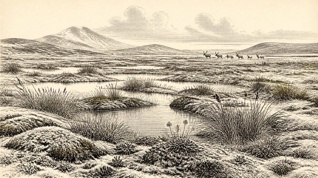
Around 31,394 BCE, Ireland was a fluctuating Late Pleistocene landscape, not a recorded historical society. Freshwater sediments at Derryvree, County Fermanagh, formed between glacial episodes, preserving evidence of treeless wetlands, sedges, grasses, mosses and aquatic plants. They indicate locally exposed, cold, wet ground before the later expansion of the British–Irish Ice Sheet. Cave remains show that mammoth, reindeer, horse, giant deer and predators reached Ireland during the broader Middle Midlandian period, though not necessarily simultaneously. Possible human activity at Castlepook remains unconfirmed as evidence of settlement. No communities, politics, monuments or traditions can be securely assigned to this remote interval.
Dateline
31,394 BCE is not a date at which Irish prehistory can be observed year by year. It is a modern calendar label, roughly 33,300 years before AD 1950, placed within the Late Pleistocene and Marine Isotope Stage 3 of the last Ice Age. No people in Ireland recorded years, and neither radiocarbon dating, pollen analysis nor glacial stratigraphy can identify an event in a single year so remote. The responsible history of this notional moment is therefore a history of dated ranges, sediments and fossil traces. It concerns an island whose landscapes, animal populations and possible human visitors were shaped by repeated climatic swings and by the approaching growth of the last Irish Ice Sheet.
A Date Within a Range
The closest useful Irish environmental archive is at Derryvree, near Maguiresbridge in County Fermanagh. Road works in 1969 exposed a drumlin cut by layers of glacial sediment. Between two tills – stony deposits laid down by ice – lay sands, silts and organic material formed in freshwater conditions. The sequence has long been assigned to the Middle Midlandian, the Irish term used for part of the last glacial cycle. Its conventional radiocarbon results indicate an age of roughly 30,500 radiocarbon years before present, with a large uncertainty; modern calibration and correlations place the deposit broadly in the mid-to-late 30th millennium before AD, not at one pinpointed calendar year. Its relevance to 31,394 BCE is chronological and environmental, rather than proof that a particular pool existed on that particular day.
This distinction matters. Radiocarbon determinations of this antiquity have wide calibrated ranges, and older measurements on bone are particularly liable to reassessment as laboratory techniques improve. The precise relationship of Derryvree to named warming episodes, including the Denekamp interstadial of north-west Europe, remains interpretative. Yet the basic stratigraphic fact is powerful: freshwater and vegetation developed at Derryvree after one phase of glaciation and before another. Around the broad time represented by 31,394 BCE, parts of Ireland were not simply an unchanging, island-wide sheet of ice. They included, at least intermittently and in places, exposed ground capable of supporting ponds, marshy hollows and cold-climate vegetation.
Water Between the Tills
The Derryvree organic deposits preserve a small but unusually valuable record because later ice advance destroyed or obscured much of Ireland’s older Pleistocene terrain. Plant macrofossils and pollen point to a largely treeless environment. Sedges, grasses, mosses and low-growing herbs, with plants suited to cold, wet ground, are more securely supported than any vision of woodland. Aquatic and marginal plants indicate standing or slow-moving freshwater. The scene was not a modern Irish bog, nor a timeless white wilderness, but a periglacial mosaic: shallow water, saturated ground, mineral sediment, open vegetation and seasonally severe weather.
Such evidence cannot yield a reliable daily temperature, rainfall total or map of every valley. It can, however, establish an important contrast with later Ireland. There was no oak forest, enclosed pasture or peatland countryside made by millennia of Holocene plant growth. Wind had greater reach over sparse cover; frost, snowmelt and shifting water could readily reshape soils and slopes. In colder phases, permafrost-related processes may have affected the ground. During relatively milder intervals, liquid water and productive wetland margins returned. The climate was unstable on scales of centuries and millennia, and a date such as 31,394 BCE falls within that longer rhythm, not outside it.
Before Full Ice-Sheet Expansion
Glacial reconstructions offer the wider framework. A leading synthesis places the major build-up of the British–Irish Ice Sheet after about 35,000–32,000 years ago, with its broad maximum much later, around 27,000–21,000 years ago. Other reconstructions similarly infer that Ireland was largely ice-free until approximately 32,000 years ago, before ice thickened and expanded over the island. These are necessarily broad models compiled from landforms, marine evidence and dates from sediments beneath till. They do not mean that every part of Ireland was ice-free, habitable or connected in the same way at every moment.
At the time represented by this article, Ireland stood near an important threshold. Ice masses and glaciers had already shaped the landscape in earlier episodes, while the climatic and glaciological conditions that would generate the more extensive later ice sheet were developing. Regional variation was decisive. Uplands, coasts, lake basins and the Irish Sea basin did not respond uniformly. An open, cold wetland such as the Derryvree setting could coexist in the wider island with local ice, snowfields, bare gravel, unstable slopes and areas where evidence has since been removed by erosion. The familiar drumlin landscapes of the north are, in part, the much later legacy of ice movement through and over these earlier deposits.
Animals on an Open Island
Fossil caves provide a second, less orderly source of evidence. At Castlepook Cave, near Doneraile in north Cork, remains attributed to the Middle Midlandian include woolly mammoth, reindeer, giant deer, brown bear, wolf, fox, Arctic fox, lemmings and spotted hyaena. At Shandon Cave near Dungarvan in County Waterford, mammoth, reindeer, horse, bear, wolf and hare have been recorded. Direct dates obtained from particular Shandon bones span a substantial interval, rather than one occupation horizon. The Irish Quaternary Fauna Project concluded that a wide range of mammals reached Ireland between at least about 45,000 and 20,000 years ago, but it also stressed the disturbed character of many old cave collections.
Accordingly, these animals must not be assembled into a census for 31,394 BCE. A mammoth tooth or reindeer limb establishes that the species occurred in Ireland during a broad phase; it does not prove that a herd passed a particular cave at this date. Nor did caves necessarily represent ordinary living landscapes. Carnivores could drag prey and scavenged carcass parts into them, water could rework deposits, and nineteenth- and early twentieth-century excavation often mixed material from different layers. Nevertheless, the fauna makes the open-country reconstruction credible. Reindeer, horse and mammoth are consistent with extensive grazing land, while hyaena, wolf and fox reveal predator and scavenger communities exploiting the same animal resources.
This was an Ireland of mobility. Large herbivores would have followed seasonal food and shelter across wide, open terrain; carnivores followed them or contested carcasses. Animal movements were not trade routes and do not demonstrate permanent human settlement, but they show that Ireland was ecologically linked to the changing landscapes of Britain and continental north-west Europe. Lower sea levels altered the geography of the Irish Sea region, although the exact configuration and ease of terrestrial movement changed through time. Insularity should therefore not be imagined in its modern form, yet neither can a single, simple land bridge be assumed for every date in MIS 3.
The Limited Human Question
Human history at this depth of time is especially uncertain. A reindeer femur from Castlepook has been reported as bearing a deep mark interpreted as a stone-tool cut made while butchering the animal, and the find has prompted renewed archaeological work. If that interpretation and dating are ultimately confirmed, it would indicate a human incursion into Ireland during the Upper Palaeolithic, radically earlier than the formerly accepted record. It would still be evidence for an encounter with one carcass, not for a village, a population or continuous occupation.
There is presently no securely dated house, hearth, stone-tool assemblage, burial, artwork or occupation surface in Ireland that can be assigned to 31,394 BCE. The best established Palaeolithic humanly modified Irish bone remains much later: a brown-bear patella from Alice and Gwendoline Cave in County Clare, directly dated to about 12,810–12,590 calibrated years before present. That later discovery proves that people did enter Pleistocene Ireland, but it cannot be projected backwards by twenty millennia. For the period around 31,394 BCE, the prudent conclusion is that human presence is possible and under investigation, not demonstrated as a settled society.
No Polities, No Proven Diplomacy
Political affairs, warfare and diplomacy cannot responsibly be reconstructed here. There are no named communities, leaders, territories, fortifications or exchanged prestige goods. If Upper Palaeolithic hunters visited Ireland, they may have belonged to small, highly mobile groups whose social networks extended across north-west Europe; that is a reasonable comparative possibility, not direct Irish evidence. Likewise, animal butchery would suggest practical knowledge of carcass processing and perhaps the use of stone tools, but it cannot establish language, kinship rules, ceremonial authority or a formal economy.
Religion and learning are equally beyond the evidence. A cave full of bones is not automatically a shrine, and an incised or cut bone is not automatically art. No ritual deposits, images, ornaments or symbolic objects can presently be tied securely to Ireland at this date. The strongest cultural conclusion is negative but important: later Irish identities, languages, monuments and traditions belong to immensely later worlds. They should not be carried back into this Ice-Age landscape.
What Can Be Said
Around the broad interval represented by 31,394 BCE, Ireland was a dynamic cold-climate environment rather than a historical nation. Freshwater deposits beneath the drumlin at Derryvree show that vegetation and wet ground existed between glacial episodes. Cave faunas show that large mammals and carnivores reached the island in the wider Middle Midlandian period. Glacial studies show that the much more extensive late ice-sheet maximum was still to come. The possibility of very early human visitors is intriguing, especially at Castlepook, but remains far more limited than claims of colonisation or settlement.
The material record is fragmentary because ice, water, time and old collecting practices have removed context as effectively as they preserved bones and silts. That is why the most accurate account of this nominal year has no kings, battles or calendar anniversaries. Its central event was environmental change: pools formed and filled, plants occupied cold ground, animals ranged through open country, and an expanding ice system was beginning to transform the possibilities of life on the island.
Primary Sources
- A Middle Midlandian Freshwater Series at Derryvree, Maguiresbridge, County Fermanagh, Northern Ireland
- The Irish Quaternary Fauna Project
- Extent and Timing of the Last Glacial Maximum (LGM) in Britain and Ireland: A Review
- The Last Irish Ice Sheet: Extent and Chronology
- Irish Pleistocene Biostratigraphy
- Palaeoecology
- Figure 6.— The Subdivision of the Quaternary Period in Ireland
- The Late Quaternary History of East-Central Ireland
- The Tolsta Interstadial, Scotland: Correlation with D–O Cycles GI-8 to GI-5?
- Irish Cave Exploration
- Notice of the Occurrence of Mammoth and Other Animal Remains
- The Horse in Late Pleistocene Europe
- Pleistocene Vertebrates in the British Isles
- Cave Hunting
- Heritage Artefacts of County Cork
- Archaeology Research Excavation Grant 2022
- First Evidence of a Late Upper Palaeolithic Human Presence in Ireland
- New Insights on the Fauna of Ireland's Younger Dryas and Early Holocene from Alice & Gwendoline Cave
- Trimlines, Blockfields and the Vertical Extent of the Last Ice Sheet in Southern Ireland
- BRITICE Glacial Map, Version 2: A Map and GIS Database of Glacial Landforms of the Last British–Irish Ice Sheet