

Maguirebridge’s Wetland Mosaic30631 BCE
Approximately 32,580 calendar years BP, the notional date falls within the Late Pleistocene and Marine Isotope Stage 3. Derryvree’s buried freshwater sediments near Maguiresbridge, County Fermanagh, record an ice-free interval between glacial advances, with cold, open, periglacial habitats containing mosses, sedges, aquatic plants, mountain avens and dwarf willow. These wetlands and sparse vegetation preceded later ice cover during the build-up to the Last Glacial Maximum. Castlepook Cave preserves a diverse fauna, including reindeer, mammoth, giant deer and carnivores, but its mixed deposits cannot reconstruct a single date. A cut-marked reindeer bone suggests early human activity, yet permanent settlement remains unproven.
Dateline
“30,631 BCE” is a modern chronological label, not a year that can be observed in the Irish archaeological record. Nobody in Pleistocene Ireland used a calendar that can be translated into that date; no contemporary writing, named people, political events or dated settlements survive. At this depth of time, even scientific dating normally gives ranges rather than a single historical day. The most responsible approach is therefore to place this notional year within the later part of the Late Pleistocene, broadly Marine Isotope Stage 3, and ask what the island’s physical and biological evidence can reveal.
Converted into the convention of calibrated years before present, with “present” fixed at 1950, 30,631 BCE is approximately 32,580 calendar years BP. This falls within the broad calibrated range associated with the famous buried organic deposits at Derryvree, near Maguiresbridge in County Fermanagh. Their conventional radiocarbon determination, Birm-166, was 30,500 ± 1,100 radiocarbon years BP. Calibration has been expressed approximately as 36,900–31,700 calendar years BP: roughly 34,950–29,750 BCE. That interval is wide, and the legacy date has limitations, but it makes Derryvree the closest direct environmental archive for understanding Ireland around this point.
A Wetland Beneath the Drumlins
Derryvree was exposed during road works in 1969, when a cutting through a drumlin revealed organic silts and fine sands trapped between two deposits of glacial till. Till is the unsorted debris left by moving ice: clay, stones and larger fragments laid down by a glacier or ice sheet. The sequence matters because the freshwater sediments show that, for a period between glacial advances, this part of Fermanagh was not buried beneath active ice. Water collected, plants grew and small organisms lived in and around a shallow basin before later ice sealed the deposit beneath another cover of till.
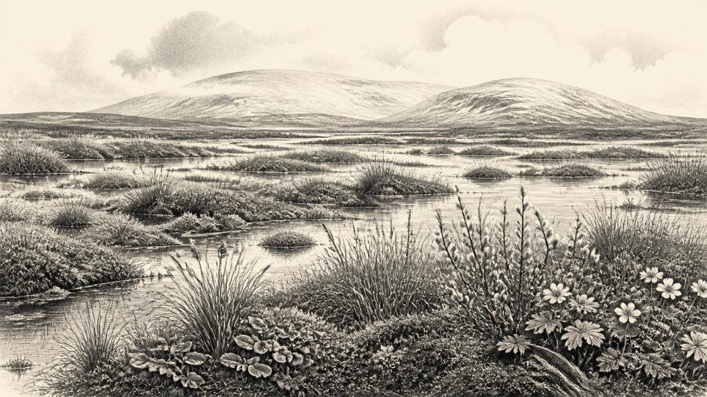
This is not evidence for a mild, wooded Ireland. Plant remains, pollen and other microfossils instead point to a cold, open and periglacial environment: terrain strongly affected by freezing and thawing close to the margins of ice. Fossils from the deposit include mosses, sedges, mountain avens (Dryas octopetala), dwarf willow (Salix herbacea), bogbean (Menyanthes trifoliata) and water-milfoil. Bogbean and water-milfoil are particularly valuable clues. They require wet ground or shallow freshwater, demonstrating that cold conditions did not mean an unbroken expanse of ice or snow. There were pools, saturated margins and sheltered hollows in which aquatic and wetland plants could persist.
Mountain avens and dwarf willow, by contrast, are plants associated with exposed Arctic-alpine settings. Together, the fossils support a varied landscape of sparse herbaceous cover, sedgy water edges, low willow, patches of moss and bare or frost-disturbed mineral ground. It is best imagined as a local mosaic, changing with drainage, exposure, snow cover and season, rather than as one uniform “tundra” stretching unchanged across the whole island. No evidence at Derryvree supports dense forest at this time. The familiar green, wooded Ireland of later millennia lay far in the future.
Ice Growing, Not a Frozen Island Entirely
The wider climatic setting was unstable. Around the North Atlantic, the later Pleistocene was marked by abrupt shifts between relatively less severe and sharply colder phases. The British-Irish Ice Sheet was growing during this long cold-age sequence, but its expansion was neither instantaneous nor identical in every region. Reviews of the Last Glacial Maximum commonly place the principal build-up after about 35,000–32,000 years ago and the maximum extent later, broadly between 27,000 and 21,000 years ago. Thus 30,631 BCE belongs to the lead-up to the greatest late-glacial ice expansion, not securely to the maximum itself.
The Derryvree deposit is important precisely because it preserves a local interval without ice cover in a landscape later overridden by ice. Evidence from western Ireland and the Atlantic shelf likewise indicates that ice-sheet behaviour varied across time and place. It would be misleading to draw a neat line around an island that was wholly ice-free one year and wholly glaciated the next. Rather, Ireland was part of a shifting north-west European zone in which ice centres, margins, frozen ground, freshwater basins and open habitats changed over centuries and millennia.
These processes have helped create the Ireland visible today. Drumlins, moraines, scoured rock, redistributed sediments and altered drainage systems are products of repeated glacial action. Yet they cannot be assigned to 30,631 BCE itself. What can be said is that the wetland sediments at Derryvree preserve an ecological moment before a later advance covered them, while the enclosing tills record the force of ice that eventually transformed the region.
Animals in a Wider Faunal World
County Cork offers a second, very different window onto this period. Castlepook Cave, near Doneraile in the Awbeg valley and also known as Mammoth Cave, has yielded one of Ireland’s most remarkable collections of Pleistocene animal remains. Material recovered chiefly in early twentieth-century excavations includes reindeer, woolly mammoth, giant deer, brown bear, wolf, foxes, hare, lemmings and spotted hyaena. The Irish Quaternary Fauna Project showed that a richer mammal community reached Ireland during parts of the period from at least about 45,000 to 20,000 years ago.
This fauna indicates that Ireland was intermittently connected to the larger ecological world of Britain and continental north-west Europe. Reindeer and lemmings are well suited to cold, open habitats; mammoth and giant deer imply productive grazing landscapes at least in suitable places; hyaenas and wolves indicate carnivore communities capable of exploiting large carcasses. Such animals did not all necessarily occupy precisely the same patch of Cork countryside at once. Nor should their presence be used to manufacture a complete food web for one date. Cave assemblages commonly combine remains accumulated over long periods by carnivores, water, natural deaths and human collectors.
That caution is especially necessary at Castlepook. Much of its material was excavated before modern methods of recording layers, positions and sediment relationships were standard. Individual specimens have distinct histories, and later work has shown that some older radiocarbon dates from Irish cave collections need reassessment using improved methods. Castlepook is therefore a powerful record of Pleistocene biodiversity, but not a snapshot of a single season. It establishes that these species belonged to Ireland’s wider Late Pleistocene fauna; it does not prove that every listed animal encountered every other one in 30,631 BCE.
The Human Question
The most arresting, but least settled, human question concerns a reindeer femur from Castlepook. Zooarchaeological examination has identified a deep mark interpreted as a possible stone-tool incision made during carcass processing. Public heritage accounts have linked the bone to an age of about 33,000 years ago. If both the diagnosis of the mark and its chronological association are sustained by further study, it may represent evidence that people handled a reindeer in Ireland well before the Last Glacial Maximum.
That possibility should not be converted into a story of a settled population. A bone date establishes when the animal died, not necessarily the exact moment a surface mark was made. The specimen does not come with a securely excavated occupation floor, hearth, stone-tool assemblage, dwelling, burial or human remains. One modified bone, even if the interpretation proves correct, could document a brief visit, scavenging or butchery episode rather than a village, a regular hunting territory or continuous descent to later inhabitants.
The securely published evidence for human activity in Ireland is much later. A cut-marked brown-bear kneecap from Alice and Gwendoline Cave in County Clare has been dated to the terminal Pleistocene, around 12,800–12,600 calibrated years BP. That is important perspective: it demonstrates how sparse Ireland’s deep archaeological record is. Any human presence around 30,631 BCE remains a serious research possibility, not an established account of society.
No Polities, No Known Trade Routes
There is consequently no basis for describing kingship, diplomacy, warfare, law, organised religion, language, formal learning or political boundaries in Ireland at this date. There are no known buildings, cemeteries, monuments, artworks or settlements from which to reconstruct households or social ranks. Nor is there direct evidence for an Irish economy, trade network or deliberate long-distance exchange. The lower sea levels of the glacial world altered the geography of the Irish Sea region, but lowered seas did not automatically create a simple permanent land bridge or demonstrate regular movement across it. Routes, coastlines and barriers changed with ice, water and terrain.
If people did enter the island, they would have been mobile foragers operating in a demanding seasonal environment, as Upper Palaeolithic groups elsewhere in Europe did. But that is an analogy, not evidence from an Irish camp. The responsible historical conclusion is more modest: Pleistocene Ireland contained habitats that could sustain plants and animals, and perhaps occasional people, while advancing ice and later erosion removed or buried much of the evidence that might otherwise tell us more.
An Archive of Limits
For 30,631 BCE, Ireland’s history is chiefly environmental history. Derryvree’s buried wetland gives the clearest local testimony: cold open ground alongside freshwater, plant life and an ice-free interval in Fermanagh. Castlepook gives a longer, complicated record of animals that moved through southern Irish landscapes during the Late Pleistocene. Together they overturn any simple picture of an eternally frozen, lifeless island. Yet they also impose limits. They cannot name a community, date an event to a modern year or establish a permanent human population. Their value lies in showing how a future island of farms, towns and kingdoms first existed as a changing northern landscape of pools, sedges, low plants, large mammals and approaching ice.
Primary Sources
- A Middle Midlandian Freshwater Series at Derryvree, Maguiresbridge, County Fermanagh, Northern Ireland
- Trimlines, blockfields and the vertical extent of the last ice sheet in southern Ireland
- Extent and timing of the Last Glacial Maximum (LGM) in Britain and Ireland: a review
- Reconstructing the last Irish Ice Sheet 2: a geomorphologically-driven model of ice sheet growth, retreat and dynamics
- Early deglaciation of the British-Irish Ice Sheet on the Atlantic shelf northwest of Ireland driven by glacioisostatic depression and high relative sea level
- The timing and magnitude of the British–Irish Ice Sheet between Marine Isotope Stages 5d and 2: implications for glacio-isostatic adjustment, high relative sea levels and ‘giant erratic’ emplacement
- Pattern and timing of retreat of the last British-Irish Ice Sheet
- Dimensions and chronology of the last ice sheet in Western Ireland
- The Irish Quaternary Fauna Project
- New insights on the fauna of Ireland's Younger Dryas and Early Holocene from Alice & Gwendoline Cave
- First evidence of a Late Upper Palaeolithic human presence in Ireland
- Phylogeographic, ancient DNA, fossil and morphometric analyses reveal ancient and modern introductions of a large mammal: the complex case of red deer in Ireland
- Figure 6.— The subdivision of the Quaternary Period in Ireland
- The Mesolithic in Ireland: when was it?
- Archaeological Heritage of County Cork
- Heritage Artefacts of County Cork
- Archaeology Research Excavation Grant Report
- BSBI: Menyanthes trifoliata
- BSBI: Dryas octopetala
- Stratigraphic and palaeo-geomorphological evidence for the glacial-deglacial history of the last British-Irish Ice Sheet in the north-western Irish Sea