Derryvree’s Permafrost Fen31490 BCE
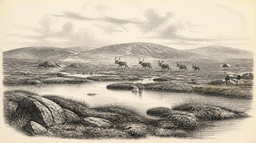
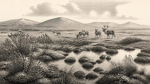
Approximately 31,490 BCE, Ireland lay within the climatically unstable Late Pleistocene, not a knowable single year. At Derryvree, County Fermanagh, organic silts between glacial tills preserve a cold, periglacial freshwater fen, with open tundra-like vegetation, shallow water and seasonal freezing. Castlepook Cave, County Cork, yielded remains of reindeer, mammoth, giant deer and predators, demonstrating wider Late Pleistocene animal dispersal, though not one simultaneous community. A cut-marked reindeer femur may indicate Upper Palaeolithic human processing, but remains contested and proves neither settlement nor continuous occupation. Later ice expansion reshaped Ireland and destroyed much earlier evidence, leaving a fragmentary environmental archive today.

Dateline
The label 31,490 BCE is a modern chronological convenience, not a year that people in Ireland could have named, recorded or experienced as a discrete historical moment. There is no annual narrative at this depth of time: no written evidence, settlements, graves, tools or securely dated human activity can be tied to that precise year. Counting without a year zero, it falls approximately 33,439 years before AD 1950, the conventional “present” used in radiocarbon reporting. That calculation should not be mistaken for calendar-year precision. The responsible picture is one of a broad Late Pleistocene interval, reconstructed from deposits whose dates have substantial ranges and from animal remains whose original contexts are often imperfectly known.
In archaeological and geological terms, this point lies within Marine Isotope Stage 3, a long, climatically unstable part of the last glacial cycle, conventionally placed at about 57,000–29,000 years ago. Ireland was not yet at the maximum extent of the final ice-sheet expansion, which came later, but nor was it a stable or uniformly habitable island. Ice, water, frozen ground, wind, vegetation and animal ranges changed over millennia and sometimes much more rapidly. The most illuminating Irish evidence close to this notional date comes not from a human site but from a buried wetland at Derryvree near Maguiresbridge, County Fermanagh.
A Freshwater Layer Between Glaciers
Derryvree was exposed during road works in 1969, when a section through a drumlin revealed a remarkable sequence. Beneath the familiar smooth hill lay two thick deposits of till, the unsorted sediment left directly by glacier ice. Between them were fine sands, freshwater silts and organic layers. The sequence records an essential fact: after one episode of glaciation and before another, this part of Fermanagh was locally free of glacier ice long enough for standing or sluggish freshwater, wet ground and living plant communities to develop.
The original radiocarbon determination from the organic deposits, BIRM-166, was 30,500 ± 1,100 radiocarbon years BP. A radiocarbon age is not identical to a calendar age, because atmospheric carbon-14 has varied through time. Calibration therefore produces a broad and uneven calendar range rather than a single translated date. Later treatments place the Derryvree material broadly within roughly 36,900–31,700 calibrated years BP. That range encompasses 31,490 BCE, but it cannot demonstrate what happened in the Fermanagh basin in that individual year. It is evidence for an environmental phase, not an Ice Age diary.
The organic silts have traditionally given their name to the Derryvree Cold Phase. This terminology matters. Older geological schemes sometimes assumed a straightforward alternation between fully glacial and relatively benign “interstadial” conditions. The Derryvree evidence instead suggests a cold, periglacial landscape: one shaped by severe frost and thaw, yet not sealed beneath local glacier ice. The survival of a wetland archive is exceptional in Ireland because later ice movement stripped, mixed, buried or destroyed so many earlier deposits.
A Treeless, Wet and Seasonal Country
Pollen, plant macrofossils, mosses and small invertebrate remains from Derryvree indicate open vegetation rather than forest. Sedges, mosses and cold-tolerant herbs dominated wet places; dwarf shrubs and sparse woody plants could occupy more sheltered ground. Finds associated with the deposit include bogbean, water-milfoil, mountain-avens, dwarf willow and juniper. These species should not be assembled into a picturesque, fixed scene. Each has its own ecological range, and fossil material may represent changing conditions within the lifetime of the deposit. Taken together, however, they support a tundra-like or muskeg environment with shallow pools, saturated ground and very short productive seasons.
There was liquid water, therefore, but not a mild Irish countryside. Winter cold, seasonal freezing and permafrost-related processes likely constrained roots, drainage and soil development. Wind-exposed ground would have been especially difficult for taller vegetation to colonise. Summers may have brought a brief surge of plant growth around pools and fens, supplying food for insects, waterfowl and herbivores, but the evidence does not allow a reliable annual temperature, rainfall total or seasonal timetable to be assigned to 31,490 BCE.
Derryvree also warns against treating “Ireland” as one environmental unit. A small wetland in south-central Ulster is a local archive. Its contents cannot prove that Cork, Connacht, the Irish Sea basin and upland districts had identical conditions at precisely the same time. Yet its position between tills confirms that substantial variation was possible: parts of the island could support cold open ecosystems while ice remained an important regional force and future glacial growth was already part of the longer climatic trajectory.
Castlepook’s Animal World
The major complement to the Fermanagh wetland lies far to the south-west at Castlepook Cave near Doneraile, County Cork. Excavations and cave exploration there have produced one of Ireland’s most significant Pleistocene faunal collections. Reindeer, woolly mammoth, giant deer, brown bear, wolf, fox, mountain hare, stoat, collared lemming, Norwegian lemming and spotted hyaena have all been identified from the cave system or its historic collections. The assemblage establishes that Ireland, at different points in the Late Pleistocene, participated in a wider north-west European world of open-country and cold-adapted mammals.
Its limitations are as important as its drama. Cave deposits can accumulate through carnivore activity, natural deaths, water movement and material falling through fissures. Much Castlepook evidence was recovered in early twentieth-century work, before modern standards of stratigraphic recording. Some bones have been directly dated, but a cave assemblage is not automatically a single living community or a snapshot of one landscape. It would be unsafe to say that every listed species stood together in north Cork in 31,490 BCE, or that their Irish populations were continuous from one warm pulse to the next.
Nevertheless, the fauna makes ecological sense beside Derryvree’s open wetland record. Reindeer and lemmings point towards cold, largely treeless habitats; hyaenas, wolves and bears reveal a food web with predators and scavengers as well as grazing animals. Woolly mammoth remains indicate that very large herbivores could reach Ireland during parts of this broader interval. Giant deer, later dubbed the “Irish elk”, were not uniquely Irish and should not be imagined as symbols of a settled national landscape. Their presence is evidence of animal dispersal and suitable forage, not of a permanent fauna in every district.
The Castlepook Human Question
A reindeer femur from Castlepook has made this era especially important for Irish prehistory. Re-examination identified a deep linear mark interpreted by zooarchaeologist Ruth Carden as a cut or chopping action made on fresh bone with a sharp stone implement. County Cork heritage material presents the bone as dating to about 31,000 BCE. If the modification is confirmed as human-made, it would be evidence that somebody processed a reindeer in Ireland during the Upper Palaeolithic, tens of millennia earlier than the long-accepted post-glacial record.
That possibility deserves attention, but not exaggeration. A radiocarbon result dates the death of the animal, rather than automatically dating the mark or identifying who made it. One modified bone does not establish a camp, a dwelling, a tool industry, a burial ground, a resident population or uninterrupted occupation. Sharp marks may require careful separation from damage caused by carnivores, sediment abrasion, breakage, weathering or excavation. Recent work at Castlepook has confirmed the research potential of surviving deposits, but its 2022 excavation found no cultural artefacts. The femur is a serious and exciting clue, not a licence to invent an Irish hunting society for this date.
No Polities, No Recorded Religion
Accordingly, political affairs, diplomacy, formal warfare, named leaders, trade routes, religious rites, art and learning cannot responsibly be described for Ireland in 31,490 BCE. There is no evidence for a polity, tribe, kingdom or organised territorial community. Nor can archaeology at present recover the language, ancestry, beliefs or social rules of any possible visitors. Even the proposition that people crossed from Britain or continental Europe at this particular time remains unproven. Lower sea levels altered coastlines and may have enlarged habitable land, but the geography of connections across the Irish Sea was variable; ice cover, sea channels and exposed ground all mattered.
If people did reach the island during the wider Castlepook horizon, the most defensible interpretation is of small, mobile Upper Palaeolithic parties operating at Europe’s north-western edge. They would have needed flexible knowledge of animals, terrain, shelter and seasonal danger. That is an inference from comparable hunter-gatherer lifeways elsewhere, not a demonstrated description of Irish households. Nothing yet connects such hypothetical visits to the communities that entered Ireland much later, after the great ice-sheet phase had passed.
An Archive of Change
The chief historical development represented by this date is thus environmental, though it shaped every possibility for animal and human movement. Derryvree preserves a cold freshwater fen formed in an interval between glacial advances. Castlepook preserves evidence that large mammals and carnivores reached the island over the broader Late Pleistocene, alongside a contested indication of human processing. Later expansion of the Irish Ice Sheet would reshape the land, help create the drumlin landscapes visible today and erase much evidence of what came before.
For 31,490 BCE, Ireland should therefore be understood neither as an empty blank nor as a fully knowable homeland. It was a changing Ice Age landscape of wet ground, open vegetation, dangerous winters and mobile fauna. The evidence is fragmentary but powerful: silts beneath a Fermanagh drumlin, bones within a Cork limestone cave, and scientific methods that continue to reassess old collections. Their lesson is caution as much as wonder. At this chronological depth, the honest history of Ireland is not a sequence of events, but a carefully bounded reconstruction of worlds that later ice nearly concealed.
Primary Sources
- A Middle Midlandian Freshwater Series at Derryvree, Maguiresbridge, County Fermanagh, Northern Ireland
- Exploring Controls of the Early and Stepped Deglaciation on the Western Margin of the British Irish Ice Sheet
- The Irish Quaternary Fauna Project
- New Insights on the Fauna of Ireland’s Younger Dryas and Early Holocene from Alice & Gwendoline Cave
- New Insights on the Fauna of Ireland’s Younger Dryas and Early Holocene from Alice & Gwendoline Cave
- Figure 6.— The Subdivision of the Quaternary Period in Ireland
- Irish Association for Quaternary Studies Guide 13
- The Geology of Ireland: Cenozoic, Tertiary and Quaternary
- Soils of County Waterford
- Trimlines, Blockfields and the Vertical Extent of the Last Ice Sheet in Southern Ireland
- A 10Be-Dated Record of Glacial Retreat in Connemara, Ireland, Following the Last Glacial Maximum and Implications for Regional Climate
- Early Deglaciation of the British-Irish Ice Sheet on the Atlantic Shelf Northwest of Ireland Driven by Glacioisostatic Depression and High Relative Sea Level
- Castlepook Cave, Castlepook South, Cork: 2022 Excavation Report
- Heritage Artefacts of County Cork
- Ireland’s Palaeolithic Archaeology – Fleeting Footprints in a Frozen Land
- A North-Western Habitat: the Paleoethology and Colonisation of a European Peninsula
- The Colonization of Ireland: A Human Ecology Perspective
- The IntCal20 Northern Hemisphere Radiocarbon Age Calibration Curve (0–55 cal kBP)
- Dansgaard–Oeschger Events in Climate Models: Review and Baseline Marine Isotope Stage 3 Protocol
- The Problem of a Late Quaternary Landbridge Between Britain and Ireland
- The Island of Ireland: Drowning the Myth of an Irish Land-Bridge?