

BIRM-166’s Mossland Basin31299 BCE
Labelled 31,299 BCE, this period cannot be identified as a precise Irish historical year, but falls within a broad late Marine Isotope Stage 3 interval. Derryvree, County Fermanagh, preserves freshwater and organic sediments between glacial tills, showing locally ice-free, biologically productive tundra-like wetland conditions. Its radiocarbon date BIRM-166 calibrates broadly to 36,900–31,700 years before present. Castlepook Cave, County Cork, records reindeer, mammoth and hyaena from changing pre-maximum glacial faunas. A marked reindeer femur may indicate human butchery, but proves neither settlement nor population. Evidence instead reveals intermittent ecological opportunities before later glaciation, not continuous habitation, societies, or events with certainty.
Dateline
31,299 BCE is not a year that can be recovered from the Irish archaeological record in the ordinary historical sense. It is a modern calendar label, approximately 33,250 calibrated years before present (where “present” is AD 1950), imposed on an era known through deposits, bones and changing landforms rather than written testimony. No Irish find can be assigned responsibly to this exact year, season or generation. The appropriate frame is the later part of Marine Isotope Stage 3, a highly variable interval of the last Ice Age, and the calibrated ranges within which individual samples fall.
The closest and most revealing Irish environmental archive is at Derryvree near Maguiresbridge in County Fermanagh. Roadworks in 1969 cut through a drumlin and exposed freshwater silts, fine sands and organic sediment between two distinct sheets of glacial till. The basic sequence is secure: an earlier ice advance deposited till; later, in an ice-free interval, freshwater and organic material accumulated; a subsequent glacier covered and sealed that landscape beneath new till. It is a remarkable survival, because later ice repeatedly scoured or disturbed much of Ireland’s older Pleistocene evidence.
A Date Within a Long Interval
Organic material from the Derryvree deposit produced radiocarbon determination BIRM-166: 30,500 radiocarbon years before present, with a substantial laboratory uncertainty of +1,170/–1,030 years. A radiocarbon age is not a calendar age. Atmospheric carbon-14 levels varied considerably during the Ice Age, and calibration converts a measurement into a probability range, not a precise historical date. Published discussion has placed the Derryvree material broadly around 36,900–31,700 calibrated years before present. The modern label 31,299 BCE falls within this broad span, but that overlap does not date a particular pool, plant, animal or human action to the numbered year.
The deposit therefore illuminates a period rather than supplying an annual chronicle. It demonstrates that northern Ireland was not simply and continuously buried beneath ice throughout the last glacial period. At Derryvree, for at least part of the interval represented by the sediments, there was exposed ground, liquid freshwater and enough biological productivity to preserve a distinctive fossil assemblage. Equally, this local evidence must not be inflated into a map of all Ireland. Conditions varied with altitude, distance from the coast, glacier margins and the abrupt climatic shifts characteristic of the North Atlantic world.
Wet Ground in a Treeless Country
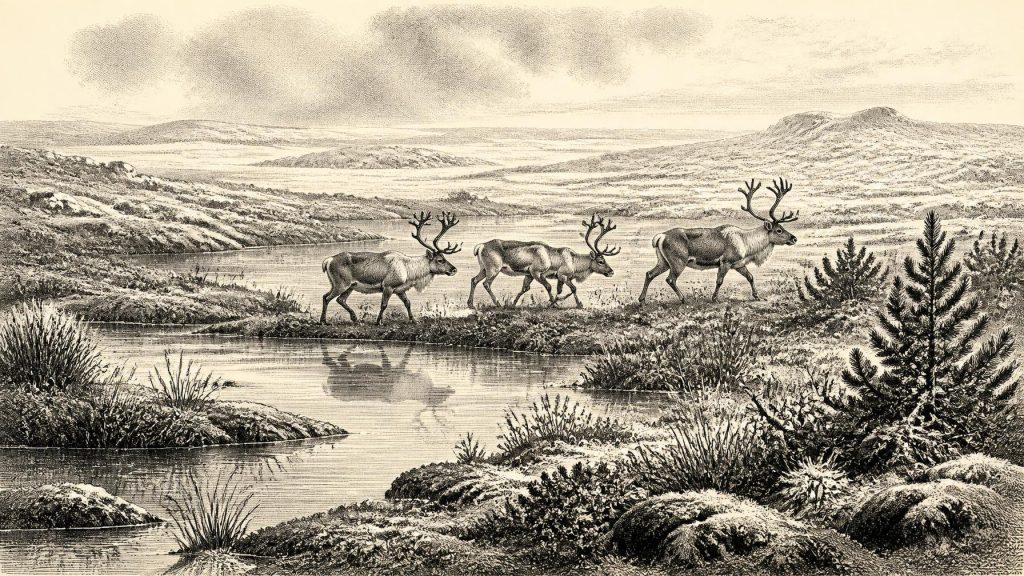
Derryvree’s pollen, plant macrofossils, mosses and insects indicate an open, cold and largely treeless environment. Grasses, sedges, herbs, juniper and a specialised moss flora point towards tundra or muskeg-like ground: waterlogged hollows, shallow pools, plant-rich margins and patches of sparse dry-land vegetation. Fossils include bogbean (Menyanthes trifoliata) and mountain avens (Dryas octopetala), plants strongly associated with cold, open conditions. The insect evidence also supports wet terrain with standing water and mossy margins rather than a uniform frozen wasteland.
This was not Ireland’s later image of dense woodland, enclosed fields and peat bogs. Short summers could bring concentrated plant growth around pools and channels, while winters were severe and prolonged frost was a major force in the landscape. Seasonal thaw, saturation and freezing would have shaped soils and sediment, and wind exposure would have limited taller vegetation. The very presence of freshwater sediment is important: it shows that water moved and pooled during the depositional phase. It does not mean that the climate was mild, nor that every part of the island was habitable in the same way.
The broader regional setting was one of change. Ireland lay at the north-western edge of Europe, connected environmentally to Britain and the exposed lands of the Irish Sea basin when sea levels were far lower than today, but its routes were never static or simple. Ice margins advanced and retreated; coastlines, rivers and lowlands shifted; and animal movements depended on terrain that could be interrupted by water, ice and inhospitable ground. The full Last Glacial Maximum lay ahead. Reconstructions generally place the last maximum expansion of the Irish Ice Sheet around 27,000–23,000 calibrated years before present, several millennia after this nominal date, although ice was already a powerful and fluctuating presence in the wider region.
Animals of the Pre-Maximum Landscape
Southern Irish caves provide a complementary, though differently preserved, record. Castlepook Cave, also known as Mammoth Cave, near Doneraile in north County Cork yielded a rich collection of Ice Age bones during antiquarian excavations in the early twentieth century. Reassessment and radiocarbon dating undertaken through the Irish Quaternary Fauna Project showed that a range of mammals reached Ireland between at least about 45,000 and 20,000 years ago. The cave record includes reindeer, woolly mammoth and spotted hyaena, among other animals. It establishes that sizeable mammals used parts of Ireland in pre-maximum phases of the last glaciation.
Cave assemblages nevertheless demand caution. Bones can be brought into caves by carnivores, water, collapse or people; they may derive from different episodes separated by many generations; and the earliest excavations did not record stratigraphy to modern standards. Castlepook should not be pictured as a single living scene in which every recorded species met at once. Rather, it is an accumulated archive of changing animal communities. Reindeer are especially compatible with the open, cold landscapes suggested by Derryvree, while mammoth and hyaena underscore that Ireland was, at intervals, part of a wider north-west European fauna rather than an isolated ecological world.
The Reindeer Femur Question
One Castlepook find brings the question of people unusually close to this period. A reindeer femur from the old collection has been reported as dating to about 31,000 BCE and bears a deep linear mark interpreted by zooarchaeologist Ruth Carden as a cut or chopping trace made by a sharp stone implement during carcass processing. If that interpretation is confirmed, it is potentially Ireland’s earliest evidence that humans handled an animal, extending the island’s known human story far beyond the much later Mesolithic record.
Its significance is real, but its limits are equally important. The bone’s date is an estimate for the death of the animal, not a timestamp for an act of butchery. A marked bone is not a settlement, and it does not demonstrate a camp, a hearth, a dwelling, a burial, a tool assemblage, a permanent population or a route of arrival. No securely associated Upper Palaeolithic occupation floor has yet been recovered in Ireland for this interval. Nor can one infer a named people, language, ancestry or repeated seasonal visits. The most cautious conclusion is that a brief human presence is possible, and that the femur may preserve evidence of it.
If people did reach Ireland during this broad phase, their likely way of life can only be inferred from the material requirements of the mark and from Upper Palaeolithic contexts elsewhere in north-west Europe. They would have been highly mobile hunter-gatherers, capable of maintaining sharp stone edges and exploiting large game. Reindeer carcasses supplied meat, marrow, hides, sinew, antler and bone; yet none of these uses can be demonstrated at Castlepook beyond the proposed modification of one femur. Hunting tactics, campsites, family size and the frequency of travel remain unknown.
No Polities, No Monuments
There is no evidence for political authority, organised warfare, diplomacy, formal religious institutions, monuments, farming, pottery, metalworking or trade networks in Ireland at this date. These are not gaps awaiting names from lost chronicles: they are categories for which the surviving record offers no support. It would be misleading to project later Irish societies, or even the much later Mesolithic world, backwards into this glacial landscape. Likewise, no art, ritual or system of learning can be attributed to Ireland around 31,299 BCE. Should the Castlepook cut mark prove anthropogenic, it would show practical knowledge and a technological act, not a documented culture in the fuller archaeological sense.
The most important development around this notional year was environmental possibility. Derryvree records an ice-free, biologically active northern landscape during a long cold interval. Castlepook records that large mammals could reach southern Ireland, and perhaps that people did too. Both archives are fragile reminders that the island’s deep past was shaped not by continuity but by repeated ecological opening and closure. Later maximum glaciation would transform the landscape again, erasing much of what had existed. What remains is enough to reject the idea of a permanently empty, wholly ice-covered Ireland before the end of the Ice Age, but far too little to turn 31,299 BCE into a conventional year of events.
Primary Sources
- A Middle Midlandian Freshwater Series at Derryvree, Maguiresbridge, County Fermanagh, Northern Ireland
- Palaeoecology
- Figure 6.— The Subdivision of the Quaternary Period in Ireland
- The Irish Quaternary Fauna Project
- Heritage Artefacts of County Cork
- 2022:564 – Castlepook Cave, Castlepook South, Cork
- Archaeology Research Excavation Grant 2022: Castlepook Cave Final Report
- Response of the Irish Ice Sheet to Abrupt Climate Change During the Last Deglaciation
- Stratigraphic and Palaeo-Geomorphological Evidence for the Glacial-Deglacial History of the Last British-Irish Ice Sheet in the North-Western Irish Sea
- The Deglaciation of the Western Sector of the Irish Ice Sheet from the Inner Continental Shelf to its Terrestrial Margin
- Timing and Pace of Ice-Sheet Withdrawal Across the Marine–Terrestrial Transition West of Ireland During the Last Glaciation
- Last Glacial Maximum Cirque Glaciation in Ireland and Implications for Reconstructions of the Irish Ice Sheet
- Trimlines, Blockfields and the Vertical Extent of the Last Ice Sheet in Southern Ireland
- The IntCal20 Northern Hemisphere Radiocarbon Age Calibration Curve (0–55 cal kBP)
- IntCal Publications
- IntCal History
- Menyanthes trifoliata
- Dryas octopetala
- Irish Pleistocene Biostratigraphy
- Phylogeographic, Ancient DNA, Fossil and Morphometric Analyses Reveal Ancient and Modern Introductions of a Large Mammal: The Complex Case of Red Deer (Cervus elaphus) in Ireland
- New Insights on the Fauna of Ireland's Younger Dryas and Early Holocene from Alice & Gwendoline Cave
- The Mesolithic in Ireland: When Was It?
- Deglacial Rates and Controls for British-Irish Ice Sheet Western Margin During the Last Glaciation
- The Geological Heritage of County Leitrim