

Castlepook’s Cutmark Debate31263 BCE
Although 31,263 BCE cannot denote a precise Irish historical year, it falls broadly within MIS 3, before the Last Glacial Maximum. Ireland experienced fluctuating ice, low sea levels and patchy, cold open environments. Derryvree sediments in Fermanagh record an ice-free freshwater wetland between glacial advances, supporting tundra-like vegetation, insects and seasonal water. Castlepook Cave in Cork preserves re-dated MIS 3 fauna including mammoth, reindeer, giant deer, predators and lemmings, demonstrating rich cold-stage ecosystems. A purported stone-tool cutmark on a reindeer bone may indicate human butchery, but remains contested. No secure evidence establishes settlement, institutions; environmental change is the clearest history.
Dateline
There can be no responsible account of events in Ireland in a literal calendar year of 31,263 BCE. No written record, settlement sequence or securely dated activity surface permits that precision. The number is a modern chronological label: expressed in the convention of calibrated years before present, it lies roughly 33,200 years before AD 1950. At that depth of time, radiocarbon results carry substantial ranges, and deposits may represent centuries or millennia rather than a single season. What can be reconstructed is a changing Late Pleistocene world in which parts of Ireland supported cold-adapted plants and animals before the Last Glacial Maximum reshaped much of the island.
A Late Pleistocene Horizon
This notional date belongs broadly to Marine Isotope Stage 3 (MIS 3), an unstable climatic interval before the coldest and most extensive phase of the last glaciation. Ireland was not simply a perpetually ice-covered land, nor a familiar temperate island. Ice expanded and contracted, sea level stood far lower than today, and the geography of western Europe differed profoundly. Britain and Ireland were connected or separated by changing lowland and marine corridors according to local ice, sea level and topography. Such reconstructions make movement by animals, and potentially by people, possible in some periods; they do not demonstrate a particular route or crossing in this particular year.
The great Last Glacial Maximum came later. Research on the British–Irish Ice Sheet places major expansion across Ireland and its surrounding shelves principally after this period, with the ice-sheet’s maximum configuration developing during the later part of the last glacial cycle. Earlier cold phases could nevertheless bring local glaciers, permafrost, severe winters and landscapes stripped of woodland. Evidence from sediments and landforms is therefore essential: later ice eroded, redeposited and buried much of the older ground surface that might otherwise preserve campsites or tracks.
Derryvree’s Wet Ground
The most instructive Irish environmental evidence comes from Derryvree, near Maguiresbridge in County Fermanagh. Road works in 1969 cut through a drumlin and revealed fine sands, freshwater silts and organic material sealed between two distinct tills. The sequence is important because the lower and upper tills record separate episodes of ice deposition, while the material between them accumulated when this locality was not overridden by glacier ice. It is not a snapshot of all Ireland, and it cannot be fixed to 31,263 BCE. Its conventional radiocarbon determination of 30,500 +1,170/−1,030 BP requires calibration and has a broad calendar-age uncertainty. Yet it securely places a cold, ice-free freshwater environment within the relevant middle part of the last glacial period.
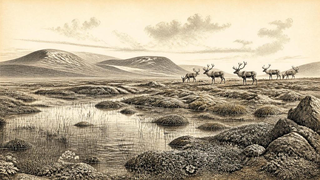
Pollen, plant macrofossils, mosses and insects in the Derryvree deposit point to open, treeless or near-treeless terrain, wet hollows and shallow freshwater. The flora included plants and mosses suited to cold ground, while the wider vegetation was dominated by herbs, grasses and sedges rather than closed forest. The term muskeg, used by earlier investigators, evokes waterlogged, peaty, moss-rich ground. “Tundra” is a useful broad comparison, provided it is not imagined as a uniform white wilderness: even a severe periglacial landscape contained contrasting microhabitats of pools, sedge margins, exposed mineral soil, sheltered slopes and patches of low vegetation.
Some pollen grains are difficult to interpret. Pollen can travel far, and older material can be reworked into younger sediments. A trace of pine or hazel pollen is consequently not proof of woodland growing beside the Fermanagh wetland. The stronger conclusion rests on the combined evidence: herb pollen, cold-adapted plant remains, mosses and insects indicate a sparse, northern environment with seasonal liquid water. The Derryvree record therefore gives everyday ecological substance to an otherwise almost invisible period of Irish history.
Animals at Castlepook
County Cork offers the other principal window. Castlepook Cave, near Doneraile in the Awbeg valley, produced a remarkable collection of Late Pleistocene animal remains during excavations led by Richard J. Ussher and colleagues in the early twentieth century. Subsequent study, especially the Irish Quaternary Fauna Project and later re-dating, has shown that some of these bones belong to a much older MIS 3 fauna than earlier radiocarbon work suggested. The assemblage includes remains attributed to woolly mammoth, giant deer, reindeer, brown bear, wolf, Arctic fox, mountain hare, collared and Norwegian lemmings, and spotted hyaena.
That list must not be treated as a census of animals standing together in one valley in one year. Cave deposits accumulate through many processes. Carnivores may drag in carcass parts; animals may die in or near caves; water and slopewash can move bone and sediment; and antiquarian excavation often disturbed or removed layers before modern recording standards existed. Direct dates apply to individual specimens, rather than to the entire collection. Even so, the bones establish that Ireland was visited or occupied by a far richer cold-stage fauna than survives on the island today. Reindeer and lemmings fit open, cold conditions; mammoth and giant deer imply extensive forage landscapes; hyaenas and wolves show that large predators also formed part of the food web.
The revised dates matter in a wider sense. Improved collagen pretreatment has made clear that some older bone dates from Irish caves were too young, because later contamination can distort results close to the practical limits of radiocarbon dating. Re-dating at Castlepook, Shandon Cave in County Waterford and Foley Cave in County Cork has pushed several specimens further back into MIS 3. This does not make every early claim secure. Rather, it illustrates why deep Irish prehistory is continually revised as museum collections, laboratory methods and stratigraphic understanding improve.
The Human Question
A reindeer femur from the Castlepook collection is especially provocative. It has been reported as bearing a deep linear mark interpreted by zooarchaeologist Ruth Carden as damage made by a sharp stone implement during butchery. The bone has been publicised as approximately 33,000 years old, close to the broad horizon represented by 31,263 BCE. If the mark was indeed made by people while the bone was fresh, it would be evidence of human handling of a reindeer in Ireland tens of millennia earlier than the traditionally accepted terminal-Pleistocene evidence.
That conclusion remains an interpretation, not an established narrative of settlement. The dated bone does not supply a camp, hearth, stone-tool assemblage, dwelling, burial, repeated kill site or evidence for a resident population. Nor does it prove that hunters lived in Castlepook Cave. The bone may have been processed elsewhere before being carried or moved into the cave system. The National Museum of Ireland still states that no clear Palaeolithic evidence of humankind in Ireland has emerged, an appropriately cautious position given the fragmentary and disturbed nature of the record. The Castlepook mark deserves further microscopic study, comparison with carnivore and natural damage, and corroboration from securely excavated deposits.
Society Without Institutions
There is no evidence for political communities, chiefs, diplomacy, territorial states or organised warfare in Ireland at this time. There are likewise no Irish data for ritual monuments, formal burials, art, language, teaching institutions, agriculture, permanent villages, pottery, metalwork or trade networks. To invent them would confuse the rich Upper Palaeolithic record of continental Europe with the very limited Irish record. If people entered Ireland during a milder interval, they were most plausibly small, mobile hunter-gatherer groups using perishable equipment and stone tools, perhaps following seasonal animal movements. But this is a model derived from comparable environments, not a fact demonstrated by an Irish campsite of this date.
The practical economy visible in the evidence is instead an ecological one. Large herbivores would have converted sparse vegetation into meat, hides, sinew, fat and bone; predators competed for carcasses; caves could become traps, dens, shelters or sediment traps. A human group capable of processing a reindeer would have needed knowledge of animal behaviour, weather, cutting tools and the risks of cold-country travel. None of that establishes trade or long-term residence. It only defines the skills that a possible short-lived human incursion would have required.
An Island in Formation
Regional change is the principal story. Fermanagh’s freshwater sediments demonstrate that an ice-free wetland existed between glacial advances. Cork’s cave fauna demonstrates that substantial mammals reached southern Ireland during MIS 3. Together, they rebut the older, over-simple picture of an island sealed beneath uninterrupted ice. They do not, however, show that every region was habitable at once. Conditions were patchy and rapidly changing, shaped by ice margins, frozen ground, drainage, vegetation, season and sea level.
For Ireland around this notional date, the most secure history is therefore environmental. Cold open ground, wetlands and mobile animal populations existed in at least some places; glaciers had not yet imposed their later maximum extent; and one contested reindeer cutmark raises the possibility of a human visit. The future Irish landscape was already being prepared by frost, flowing water, ice and sediment. But the later island of farms, kingdoms, churches and towns remained unimaginably distant.
Primary Sources
- A Reconsideration of the Radiocarbon Dating of the Marine Isotope Stage 3 Fauna from Southern Ireland
- New Insights on the Fauna of Ireland’s Younger Dryas from Alice and Gwendoline Cave, County Clare
- The Irish Quaternary Fauna Project
- A Middle Midlandian Freshwater Series at Derryvree, Maguiresbridge, County Fermanagh, Northern Ireland
- Early Midlandian–Middle Midlandian, Pleistocene, Northern Ireland
- Palaeoecology
- Figure 6.— The Subdivision of the Quaternary Period in Ireland
- Freshwater Organic Deposits and Stratified Sediments Between Early and Late Midlandian (Devensian) Till Sheets, at Aghnadarragh, County Antrim, Northern Ireland
- Middle Midlandian Interstadial Deposits at Greenagho, Near Belcoo, County Fermanagh, Northern Ireland
- Late Pleistocene Chronostratigraphy and Ice Sheet Limits, Southern Ireland
- Growth and Retreat of the Last British–Irish Ice Sheet, 31,000 to 15,000 Years Ago: the BRITICE-CHRONO Reconstruction
- Maximum Extent and Readvance Dynamics of the Irish Sea Ice Stream and Irish Sea Glacier Since the Last Glacial Maximum
- Dating Constraints on the Last British-Irish Ice Sheet: A Map and Database
- The IntCal20 Northern Hemisphere Radiocarbon Age Calibration Curve (0–55 cal kBP)
- European Middle and Upper Palaeolithic Radiocarbon Dates Are Often Older Than They Look: Problems with Previous Dates and Some Remedies
- Prehistoric Details: Mell Flint Flake
- Heritage Artefacts of County Cork
- Occurrence of Mammalia Relicts at Site Castlepook Cave
- Quaternary Data and Maps
- Ireland Through Geological Time