

Ballyhoura Reindeer Carcass31264 BCE
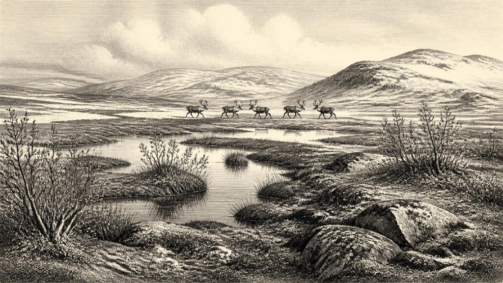
About 31,264 BCE, Ireland lay within the unstable cold conditions of Marine Isotope Stage 3, before the Last Glacial Maximum. Evidence cannot reconstruct a single year or prove permanent human settlement. At Derryvree, County Fermanagh, sediments between glacial tills preserve a treeless tundra wetland of mosses, sedges, insects and freshwater pools. Castlepook Cave, County Cork, contains a long, mixed assemblage of cold-stage animals, including reindeer, mammoth, giant deer, bear and hyaena. A cut-marked reindeer femur may indicate carcass processing by people, but lacks associated occupation evidence. Ireland was thus an ecologically varied, intermittently habitable, poorly documented Ice Age frontier overall.
Dateline
The label 31,264 BCE is a modern way of locating a point deep in the Ice Age, not a year from which Ireland preserves an event, a ruler or a dated human biography. It falls about 33,214 years before the conventional radiocarbon reference year of AD 1950, within the Late Pleistocene and Marine Isotope Stage 3 (MIS 3). Archaeology and environmental science cannot resolve conditions in Ireland to one calendar year at this depth. The responsible approach is to use dated ranges, deposits and specimens: evidence that can illuminate a broad interval around the notional date, while keeping clear what remains uncertain.
A Cold-Stage Islandscape
Ireland around this time belonged to the long, unstable cold phase usually called the Midlandian in Irish Quaternary studies. It was not yet the Last Glacial Maximum, when ice expanded much more extensively across and around Ireland after roughly 26,000 years ago. The climate nevertheless oscillated sharply over centuries and millennia. Temperatures, precipitation, sea level, vegetation and the margins of glaciers all changed in response. A single nationwide landscape cannot be reconstructed for 31,264 BCE, because the surviving evidence is sparse, local and often disturbed by later ice, water and quarrying.
There is good reason, however, to reject the picture of an unbroken white wilderness. In parts of Ireland, cold but non-glacial ground supported open vegetation, wetlands and grazing animals. The wider sea floor was exposed much farther than it is now as global sea levels fell, altering coasts and the geography of travel. Yet Britain and Ireland were not thereby simply joined by a dependable dry-land corridor. Any movement of people or animals into Ireland had to negotiate an evolving, cold-water maritime and coastal landscape whose precise routes are not securely known.
Later ice sheets did more than transform the terrain: they removed or buried much of the evidence that might once have recorded camps, tracks, hearths and animal kills. This is one reason why Irish evidence for the Upper Palaeolithic is so meagre compared with that of continental Europe or even Britain. Absence of a site is not proof that no person ever arrived; equally, a small number of finds cannot demonstrate a resident population. The historical record for this period is chiefly a record of what ice-age geology and caves happened to preserve.
Derryvree’s Tundra Wetland
The clearest local environmental archive relevant to this date lies beneath a drumlin at Derryvree near Maguiresbridge, County Fermanagh. Roadworks in 1969 exposed organic silts and fine sands trapped between two separate till sheets. The lower till records an earlier advance of ice; the upper till records a later one. Between them lay freshwater sediments made when this part of Fermanagh was ice-free, though emphatically cold.
A legacy radiocarbon determination from the organic deposit, Birm-166, was reported as 30,500 radiocarbon years BP with a large uncertainty. Calibration produces a broad range, commonly expressed as approximately 36,900–31,700 calibrated years BP. That range overlaps the notional date of 31,264 BCE, but it does not allow anyone to claim that the Derryvree wetland was sampled in that precise year. The large range matters: it represents many generations of environmental change, and the reliability of old pre-Last Glacial Maximum radiocarbon measurements is assessed cautiously in more recent ice-sheet chronologies.
What Derryvree does securely contribute is a vivid environmental pattern. Mosses, sedges, herb pollen, plant macrofossils and insects indicate a treeless, periglacial setting. The flora included cold-adapted plants associated with tundra and wet ground, while the insect evidence likewise pointed to northern conditions. Pools and waterlogged patches occurred amid open vegetation rather than dense woodland. Dry ground may have been thinly vegetated and exposed to frost action, while sheltered hollows retained freshwater. This was a productive but seasonal mosaic, not an empty desert.
Derryvree is evidence for south Fermanagh, not a complete map of Ireland. Nevertheless, it establishes an important possibility for the island at this stage of MIS 3: areas beyond active ice could carry wetland plant communities and support animal life. It also gives Irish history a rare ecological baseline. The political map, settlement pattern and social identities of the time are unknown; the rhythm best recovered is that of freezing, thawing, sedge growth, standing water and the passage of animals across open ground.
The Castlepook Faunal Archive
In north Cork, Castlepook Cave near Doneraile provides the complementary archive of animals. Its limestone passages, including galleries historically named Hyenahall and Elephant Hall, yielded more than 2,000 bones during excavations in the early twentieth century. Geological Survey Ireland describes it as Ireland’s richest known site for vertebrate fauna in the period before the Last Glacial Maximum. Radiocarbon dates on individual bones extend across a very long span, from about 45,700 to 19,950 years BP. The cave was therefore a repository used, or entered, repeatedly over thousands of years; it was not a sealed snapshot of one season.
The assemblage includes reindeer, woolly mammoth, giant deer, brown bear and spotted hyaena, alongside later records of wolf, Arctic fox, Norwegian lemming and collared lemming. These animals should not be imagined as standing together at one moment. Several species belong to different portions of the cave’s long chronology, and water disturbance has mixed some deposits. Yet the broadly pre-maximum fauna shows that Ireland could sustain a suite of large grazers, browsers, predators and scavengers in cold open landscapes. A cave could acquire bones from animals dying there, carnivores carrying prey inside, water moving material, and perhaps people.
Reindeer are especially appropriate guides to this setting. They thrive in open, cold environments and can make use of a varied tundra vegetation. Mammoths and giant deer point to substantial forage somewhere in the surrounding region, rather than a uniformly barren landscape. Spotted hyaena is equally important, because it warns against treating every accumulated bone as the result of human hunting. Carnivores are active agents in cave assemblages. Tooth marks, breakage, scavenging and redeposition can all resemble or complicate human signatures.
The Marked Femur
Castlepook has become central to the question of Ireland’s earliest people because a reindeer femur from its old collections bears a deep incision. Zooarchaeologist Ruth Carden has interpreted the mark as one made by a sharp stone tool during carcass processing. Public accounts have described the bone as roughly 33,000 years old, and the discovery prompted renewed investigation of the cave by archaeologists, cavers and specialists supported through the Royal Irish Academy. If the incision is correctly identified as a cut mark and belongs to the same broad age as the bone, it is potentially the earliest evidence that people handled an animal in Ireland.
The appropriate conclusion remains deliberately modest. The femur does not establish a year of arrival, a permanent settlement, a named Upper Palaeolithic culture or descent from these possible visitors to later Irish populations. No securely associated hearth, stone-tool assemblage, built shelter, burial, occupation surface, artwork or human skeletal remains has yet been demonstrated at Castlepook for this period. Nor does an animal-bone date automatically date the making of a mark on that bone. These limitations are not technical quibbles; they determine the difference between evidence for one act of carcass processing and a claim for an inhabited country.
Even so, the conditional human interpretation is historically significant. If a small party butchered reindeer near Castlepook, it possessed a sharp lithic edge and knowledge of how to exploit a large carcass. The meat, fat, marrow, hide, sinew and bone of such an animal could all have mattered to mobile hunter-gatherers in a cold climate. This would suggest a brief foraging visit or perhaps a wider pattern of seasonal movement, but the evidence cannot decide between them. It also cannot tell us whether the animal was hunted, scavenged after a predator kill, or encountered already dead.
Society Beyond Recovery
There is no responsible evidence for political affairs, diplomacy, warfare, leadership, property boundaries or relations between named communities in Ireland around 31,264 BCE. Nor is there evidence for formal religion, ritual monuments, writing, schools or artistic traditions on the island at this date. It would be tempting to borrow richly documented Upper Palaeolithic societies from France, Spain or central Europe and place them in Ireland; that would be interpretation by analogy, not Irish history. Continental parallels may show what Homo sapiens elsewhere were capable of, but Castlepook’s single possible human trace cannot carry that cultural weight.
The same restraint applies to economy and trade. There is no evidence for Irish exchange networks, managed herds, farming or permanent villages. If the femur records human work, the only defensible economic statement is narrow: people may have obtained useful resources from a reindeer carcass. Their tools, origins, language, kinship, clothing and destination remain unknown. The island’s most securely documented inhabitants at this point are plants and animals, not people.
Regional contrast is therefore the main story. Fermanagh’s inter-till freshwater deposits reveal a tundra wetland preserved below later glacial sediment. North Cork’s cave preserves the bones of a changing cold-stage fauna, perhaps including one reindeer processed with a stone edge. Both records show that Ireland was environmentally diverse and intermittently habitable before the full glacial advance. Both also show why historical precision has limits. Around 31,264 BCE, Ireland was a cold, open and changing frontier whose most persuasive witnesses are mud, mosses, insects and bones.
Primary Sources
- A Middle Midlandian Freshwater Series at Derryvree, Maguiresbridge, County Fermanagh, Northern Ireland
- The Irish Quaternary Fauna Project
- Castlepook Cave: Cork County Geological Site Report
- Early Midlandian–Middle Midlandian, Pleistocene, Northern Ireland
- Palaeoecology
- The Subdivision of the Quaternary Period in Ireland
- Late Pleistocene Chronostratigraphy and Ice Sheet Limits, Southern Ireland
- Dimensions and Chronology of the Last Ice Sheet in Western Ireland
- Exploring Controls of the Early and Stepped Deglaciation on the Western Margin of the British Irish Ice Sheet
- Maximum Extent and Dynamic Behaviour of the Last British–Irish Ice Sheet West of Ireland
- Oscillating Retreat of the Last British-Irish Ice Sheet on the Continental Shelf Offshore Galway Bay, Western Ireland
- Character of Advance and Retreat of the Southwest Sector of the British-Irish Ice Sheet During the Last Glaciation
- Last Glacial Maximum Cirque Glaciation in Ireland and Implications for Reconstructions of the Irish Ice Sheet
- 2022:564 – Castlepook Cave, Castlepook South, Cork
- Archaeological Heritage of County Cork
- Heritage Artefacts of County Cork
- The Mesolithic in Ireland: When Was It?
- New Insights on the Fauna of Ireland’s Younger Dryas
- Freshwater Organic Deposits and Stratified Sediments Between Early and Late Midlandian (Devensian) Till Sheets, at Aghnadarragh, County Antrim, Northern Ireland
- European Vegetation During Marine Oxygen Isotope Stage-3
- The Tolsta Interstadial, Scotland: Correlation with D–O Cycles GI-8 to GI-5?
- The IntCal20 Northern Hemisphere Radiocarbon Age Calibration Curve (0–55 cal kBP)