
Derryvree’s Intertill Macrofossils30174 BCE
Thirty thousand one hundred and seventy-four BCE is a calendar label within Marine Isotope Stage 3, not a datable event. Derryvree, County Fermanagh, preserves freshwater sediments between glacial tills, showing a locally ice-free, cold, treeless wetland during a broadly dated interval. Plant, insect and pollen remains indicate sedges, grasses, mosses, herbs and shallow pools, rather than forest or settlement. Castlepook Cave, County Cork, holds long-accumulated remains of mammoth, giant deer, reindeer, bears and hyaenas, demonstrating varied fauna but not a contemporary community. No secure evidence confirms human occupation. These fragmentary deposits document changing habitats before Last Glacial Maximum ice growth.
Dateline
A Calendar Label, Not an Event
“30,174 BCE” is a useful modern label, but it cannot identify an event, a ruler, a journey or even a single season in Ireland. At this depth of time there are no written records, no securely dated settlements and no annual chronology. The date corresponds approximately to 32.2 thousand years before AD 2000, within the Late Pleistocene and Marine Isotope Stage 3, a climatically unstable part of the last Ice Age. Greenland ice-core chronology places this broad point close to Greenland Stadial 5.2, following a short warmer interval; that is a valuable North Atlantic comparison, not a demonstration that Ireland changed on precisely the same day or year.
The responsible history of Ireland at this point is therefore environmental and archaeological rather than year-by-year. The island was not a country, nor was it inhabited by any known political community. Its modern counties, coastlines, languages and identities lay unimaginably far in the future. What can be investigated is a changing land of ice, exposed ground, pools, caves, plants and animals. The evidence is fragmentary because later glaciers eroded, transported and buried much of the Pleistocene landscape. Yet a handful of surviving deposits, especially at Derryvree in County Fermanagh and Castlepook Cave in County Cork, illuminate conditions broadly relevant to this nominal date.
Dating a Cold Landscape
Precision must begin with the dating itself. Radiocarbon ages are measured in radiocarbon years before present, with “present” conventionally fixed at AD 1950; they are not calendar dates. Changing concentrations of atmospheric carbon-14 mean that a measurement must be calibrated against independently dated records. IntCal20, the current internationally used Northern Hemisphere calibration curve for this period, reaches back to 55,000 calibrated years before present, but calibration produces probability ranges rather than an annual timestamp.
The key Derryvree sample, BIRM-166, yielded an age of 30,500 radiocarbon years BP, with an uncertainty of +1,170 and −1,030 years. Modern calibration places the result within a very broad span, approximately 36,900–31,700 calibrated years BP, or about 34,950–29,750 BCE. Thus 30,174 BCE falls within the possible calendar range of this deposit, but cannot be assigned to a particular layer, seed, insect, animal or generation. The sample records a lengthy interval of deposition and uncertainty, not a diary entry.
This distinction matters because Ireland was regionally diverse and changing quickly. A cold spell registered in Greenland may have altered temperature, precipitation, sea ice and glacier balance around the North Atlantic, but local Irish responses depended on altitude, exposure, drainage and the timing of ice advance. The later Last Glacial Maximum, when Ireland was extensively ice-covered, belongs chiefly to roughly 27,000–23,000 calibrated years BP. Ice-sheet reconstructions indicate substantial growth after about 32,000 years BP, followed by asynchronous advances in different sectors; they do not support a single, static ice margin for the whole island at 30,174 BCE.
Fresh Water Between the Tills
Derryvree townland, near Maguiresbridge in County Fermanagh, supplies the most informative local evidence. Roadworks in 1969 cut through a north-east to south-west drumlin and revealed thick glacial till below and above a sequence of fine sands, silts and organic freshwater sediments. Till is the unsorted mixture of clay, stones and debris laid down directly by glacier ice. The stratigraphy therefore establishes a secure relative sequence: ice occupied the locality; an ice-free phase allowed fresh water and organic material to accumulate; then a later glacier overrode and sealed the wetland beneath another till sheet.
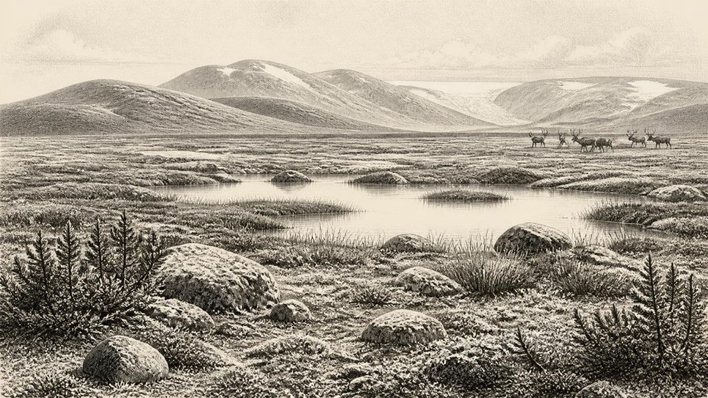
The material between the tills does not show a forest, village or agricultural clearing. Pollen, plant macrofossils, mosses and insects instead indicate an open, treeless and periglacial setting. Grasses and sedges were important; juniper and low herbs occurred; aquatic and wetland plants testify to shallow or slow-moving water. Mossy, waterlogged ground with open pools has often been described as muskeg or tundra. These are modern ecological analogies, useful for conveying a cold, wet, largely unwooded mosaic, rather than claims that the Fermanagh landscape duplicated a present-day Arctic wetland.
The evidence supports a modest but significant conclusion: at some point during the dated interval, Derryvree was locally ice-free and biologically productive. It does not prove that all of Ireland was simultaneously open ground, nor that the site was a refuge in any deliberate human sense. Pools accumulated sediment and preserved small organic remains precisely because they lay in a low, wet basin. Nearby uplands and other regions may have been far more exposed, frozen or affected by glacier growth. In this era, the difference between a sheltered freshwater hollow and an ice-scoured slope could be decisive.
Animals of the Cork Cave
Far to the south-west, Castlepook Cave near Doneraile in County Cork preserves a complementary, though differently formed, record. Also called Mammoth Cave, it is Ireland’s richest known cave assemblage for vertebrate life leading up to the Last Glacial Maximum. More than 2,000 bones have been recovered from its passages and chambers. The fauna includes woolly mammoth, giant deer, reindeer, brown bear and spotted hyaena, while other Ice Age material includes wolf, Arctic fox and lemmings.
These animals make clear that Ireland could sustain, or receive, a varied cold-stage fauna. Large herbivores point to substantial areas of forage beyond the cave; predators and scavengers point to food chains rather than empty ice. But the cave cannot be treated as a snapshot of 30,174 BCE. Individual bones carry radiocarbon dates spanning a long interval, approximately 45,700 to 19,950 years BP, and water movement, carnivore activity and early excavation have complicated their contexts. A mammoth, hyaena and reindeer represented in the collection need not have lived together, died together or passed the cave in the same century.
The Castlepook dates conventionally associated with mammoth and spotted hyaena, around 33,500 ± 1,200 and 34,300 ± 1,800 radiocarbon years BP respectively, place parts of the assemblage broadly near the Derryvree cold-phase record, but calibration and context demand caution. The cave is best understood as a long-accumulating repository of animal remains, not as a camp-site, kill-site or census of a single landscape. Its importance lies in demonstrating that the Irish landmass, before full Last Glacial Maximum conditions, was ecologically more varied than the image of an entirely lifeless frozen island suggests.
No Politics, No Proven Settlement
There is no evidence from 30,174 BCE for government, diplomacy, warfare, named leaders, ethnic groups, trade networks, religion or formal learning in Ireland. Neither should these absences be filled with imaginative reconstructions of “tribes” meeting mammoth hunters. No secure human settlement, hearth, tool assemblage or burial is known from the island for this period. The National Museum of Ireland accordingly states that clear evidence for human presence during the Palaeolithic has not emerged.
This does not mean people were absent from neighbouring regions. Upper Palaeolithic communities lived elsewhere in Britain and continental Europe, where archaeology records stone technology, hunting and social life. Lower sea levels also changed the geography of north-west Europe, exposing parts of the continental shelf. Yet a potential route is not proof of an Irish crossing, and the presence of mammals is not proof of human occupation. The strongest currently known Irish evidence for a human incursion is much later: cut-marked brown-bear bone from Alice and Gwendoline Cave, County Clare, dated to 12,810–12,590 calibrated years BP. Sustained, incontrovertible settlement belongs later again, to the Mesolithic.
A proposed cut mark on a Castlepook reindeer femur has occasionally been discussed as possible earlier evidence of human butchery. It deserves continued scientific scrutiny, but it cannot responsibly establish a population, society or event at this date. Cave assemblages are difficult to interpret, and a single marked bone cannot supply what is missing: secure archaeological context, associated tools, repeated activity and direct dating of human presence. The more defensible conclusion is that Ireland’s human history at 30,174 BCE remains unproven.
Landscape Before the Maximum Ice
For society and everyday life, the evidence is therefore environmental rather than human. The “everyday life” recoverable from Derryvree is that of plants, insects and animals: sedges rooted at wet margins; mosses occupying damp ground; aquatic plants in pools; grazers moving across open terrain; carnivores exploiting carcasses or denning in caves. Seasonal contrasts were probably severe. Frost action, sparse vegetation and wet ground would have shaped movement and survival, while renewed glacier advance could erase whole habitats.
There was no Irish economy or trade in the historical sense. Natural mobility nevertheless mattered. Mammals could move when land, climate and food permitted; water and ice imposed barriers; and lowered sea level altered the wider geography beyond today’s shore. The evidence does not show regular exchange or seafaring. It shows a landscape connected to wider north-west European ecological processes while remaining repeatedly transformed by ice.
Religion, art and learning are likewise beyond recovery here. There are no monuments, pigments, carvings or artefacts from which to infer ceremony or symbolic culture in Ireland at this time. The true cultural achievement is modern: the careful reading of silt, pollen, bone, insect remains and glacial deposits. Derryvree’s buried basin and Castlepook’s cave bones do not yield an annual Irish story. They preserve something older and more contingent: evidence that, around the broad interval represented by 30,174 BCE, parts of Ireland contained cold, open and locally watery habitats on the eve of more extensive ice-sheet growth.
Primary Sources
- A Middle Midlandian Freshwater Series at Derryvree, Maguiresbridge, County Fermanagh, Northern Ireland
- Palaeoecology
- The Subdivision of the Quaternary Period in Ireland
- Irish Pleistocene Biostratigraphy
- The Irish Quaternary Fauna Project
- Castlepook Cave
- Mammoth Cave
- A Reconsideration of the Radiocarbon Dating of the Marine Isotope Stage 3 Fauna from Southern Ireland
- Growth and Retreat of the Last British–Irish Ice Sheet, 31,000 to 15,000 Years Ago: the BRITICE-CHRONO Reconstruction
- The Deglaciation of the Western Sector of the Irish Ice Sheet from the Inner Continental Shelf to its Terrestrial Margin
- Maximum Extent and Dynamic Behaviour of the Last British–Irish Ice Sheet West of Ireland
- Last Glacial Maximum Cirque Glaciation in Ireland and Implications for Reconstructions of the Irish Ice Sheet
- Ireland: Submerged Prehistoric Sites and Landscapes
- Prehistoric Details
- First Evidence of a Late Upper Palaeolithic Human Presence in Ireland
- The IntCal20 Northern Hemisphere Radiocarbon Age Calibration Curve (0–55 cal kBP)
- A Stratigraphic Framework for Abrupt Climatic Changes During the Last Glacial Period Based on Three Synchronized Greenland Ice-Core Records: Refining and Extending the INTIMATE Event Stratigraphy
- The Greenland Ice Core Chronology 2005, 15–42 ka: Part 1: Constructing the Time Scale
- North GRIP – Greenland Ice Core Chronology 2005 (GICC05) Holocene Section, 20-Year Resolution
- Ireland Through Geological Time
- Soils of County Waterford
