Derryvree’s Freshwater Archive31121 BCE
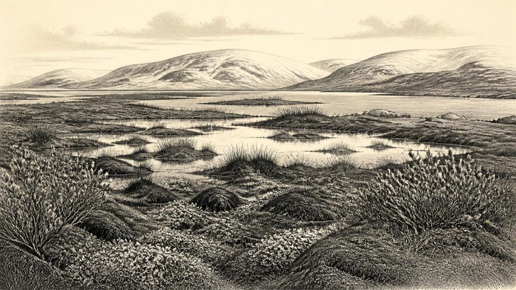
Around 31,121 BCE, Ireland’s history is reconstructed from environmental archives rather than written records. At Derryvree, County Fermanagh, freshwater sediments between glacial tills indicate a locally ice-free, treeless periglacial wetland during a broadly dated interval, supporting mosses, sedges, tundra plants, insects and seasonal pools. Castlepook Cave, County Cork, preserves time-averaged remains of mammoth, reindeer, giant deer, predators and other Ice Age fauna, demonstrating open grazing landscapes before maximum glaciation. A marked reindeer bone may indicate Upper Palaeolithic butchery, but remains unconfirmed. Evidence supports shifting ice margins and possible brief human visits, not permanent settlement, institutions or identifiable communities there then.
Dateline
“31,121 BCE” is a modern label, not a year that anyone in Ireland could have named or recorded. There was no calendar, writing, ruler, settlement chronicle or event list from which to construct an annual history. In archaeological terms, this point lies roughly 33,070 years before AD 1950, the conventional reference point for “before present” dating, during the Late Pleistocene and Marine Isotope Stage 3. Calendar precision at this depth is unattainable: radiocarbon results require calibration and commonly produce ranges of centuries or millennia. The responsible history of Ireland at this date is therefore an account of landscapes, deposits, animals and a small but important question about human presence.
A Date Within a Long Interval
The most illuminating evidence comes not from a site securely dated to this numbered year, but from Derryvree near Maguiresbridge in County Fermanagh. Roadworks in 1969 cut through a drumlin and exposed an exceptional sequence: glacial till beneath, freshwater silts and organic sediments in the middle, and a further till above. This arrangement matters because it records an interval when the locality was free of overriding ice between episodes of glaciation. A radiocarbon determination from the organic layer, BIRM-166, gave 30,500 ± 1,100 radiocarbon years BP. When calibrated, this has been treated broadly as falling about 36,900–31,700 calendar years BP. The modern date 31,121 BCE sits near the younger end of that wide interval, not at a detectable moment within it.
The Derryvree deposit does not provide a snapshot of a single season. Sediment accumulated over time; plant remains, pollen and insects came from the surrounding catchment; later ice sealed the layer beneath till. Yet precisely because it was sealed, it preserves rare evidence of an Irish landscape that later glaciation largely erased. It shows that at least part of north-central Ireland could support open ground, standing and slow-moving freshwater, mossy vegetation and animal life during a cold phase long before the fullest expansion of the last British–Irish Ice Sheet.
Cold Water, Open Ground
The environmental evidence points to a treeless, periglacial wetland rather than a forested island or a featureless sheet of snow. Derryvree’s plant macrofossils include mosses and cold-adapted wetland and tundra plants, among them sedges, bogbean (Menyanthes trifoliata), dwarf willow and mountain-avens. Pollen was poorly preserved, but the record is dominated by herbs and grasses rather than trees. Insects add another layer of evidence: their ecological requirements indicate wet ground rich in decaying plant matter, open pools and mossy margins. Together, these lines of evidence support the interpretation of a muskeg-like mosaic of shallow water, saturated sediment, low vegetation and sparsely vegetated drier patches.
Such a place would have been intensely seasonal. Winters were severe, with frost action shaping exposed ground; summers were short but capable of sustaining sedges, herbs, mosses and aquatic plants. The word “tundra” is useful only if it does not conjure an unchanging polar desert. Derryvree suggests variety at a local scale: pools, wet hollows, plant-rich margins and open dry surfaces. The exact temperature, snow cover and length of the growing season cannot be read directly from one buried bed. They are reconstructed from fossil species and sedimentary context, and should remain interpretations rather than treated as observed weather.
An Island Before Maximum Ice
Ireland’s position at about 33,000 calendar years ago was unstable. The last ice sheet had not yet reached its best-established island-wide maximum, which came substantially later, broadly during the period around 26,000–21,000 years ago, although different sectors advanced and retreated at different times. Modern reconstructions of the British–Irish Ice Sheet emphasise this unevenness. It would be misleading to say simply that Ireland was either wholly frozen or wholly ice-free in 31,121 BCE. Regional conditions differed, and the resolution of available dates cannot map an ice edge for one calendar year.
Derryvree demonstrates local ice-free conditions in Fermanagh during its dated interval. It does not prove that every Irish valley, upland and coast was simultaneously open, nor does it identify a continuous route across the island. Conversely, later ice did not obliterate every trace of the earlier landscape: the freshwater bed survived precisely because it lay between glacial deposits. Ireland’s modern drumlins, tills, lake basins and river courses were profoundly shaped by repeated glacial episodes, but the landform visible today is not a simple map of conditions at this remote date.
Castlepook’s Animal Record
County Cork offers a different kind of evidence. Castlepook Cave, near Doneraile, has produced one of Ireland’s richest Late Pleistocene faunal collections. Its long sequence includes remains of woolly mammoth, reindeer, giant deer, brown bear, wolf, Arctic fox, lemmings and spotted hyaena. Several specimens have radiocarbon ages placing them in Marine Isotope Stage 3, including around 34,000–35,000 radiocarbon years BP for some mammoth, hyaena and reindeer remains. Those determinations are not equivalent to the modern BCE label in this article: a radiocarbon age must be calibrated, and the cave accumulated material over a long period.
Nevertheless, Castlepook establishes an essential point. In suitable pre-maximum glacial phases, southern Ireland formed part of a wider north-west European world inhabited by large grazing animals and their predators. Reindeer imply extensive open country; mammoth and giant deer indicate substantial herbivore resources; hyaenas, wolves and bears point to a functioning carnivore guild. Caves were not necessarily domestic shelters. Carnivores could drag remains inside, animals could die in natural traps, water could move bones, and early excavations did not record contexts to modern standards. Castlepook is best understood as a time-averaged faunal archive, not as a single living landscape frozen in time.
The Human Question
A reindeer femur from Castlepook has made this broad period especially significant. The bone has been publicly reported as approximately 33,000 years old and bears a deep mark interpreted by zooarchaeologist Ruth Carden as damage from a sharp stone tool during carcass processing. If that diagnosis and chronology are confirmed through full specialist study, it would indicate human handling of a reindeer in Ireland during the Upper Palaeolithic, far earlier than the island’s long-established post-glacial settlement record.
The limits of the evidence are as important as its promise. A bone dates the death of an animal within a range; it does not date an individual person, camp or journey to a calendar year. Nor does a single incision automatically establish butchery, since bone can be altered by carnivore teeth, trampling, sediment abrasion, breakage and excavation damage. Castlepook’s deposits were disturbed by animal activity, water movement and early twentieth-century digging. No securely associated hearth, stone-tool assemblage, dwelling floor, burial, art panel or repeated occupation surface of this age has yet been published from Ireland. The reindeer bone may signal a brief visit or hunting episode; it cannot demonstrate a settled population, a named people or continuity with later inhabitants.
Society Beyond the Evidence
For that reason, conventional headings such as politics, diplomacy and war have almost no direct content here. There is no evidence for Irish kingdoms, chiefs, territorial boundaries, treaties, organised conflict or institutions. Equally, there is no Irish evidence from this date for farming, herding, pottery, metalwork, monuments, formal trade, writing, religion or art. These absences are not proof that no social relationships existed among any people who may have entered the island; they are limits imposed by the surviving record.
If people did visit, their everyday life would have depended on mobility, weather, animal behaviour and access to stone, fuel and shelter. Across north-west Europe, Upper Palaeolithic groups used sophisticated stone technologies and exploited large game, but that continental context must not be converted into unproven Irish detail. No particular tool tradition can responsibly be assigned to Castlepook, and there is no basis for imagining a permanent camp beside Derryvree’s pools. Exchange or movement across the exposed continental shelves and through Britain is plausible in broad geographical terms, but no Irish artefact or imported material demonstrates a trade network at this point.
What This Year Can Mean
The most important development represented by 31,121 BCE is not a dated human event but the survival of evidence from a vulnerable interval before renewed, more extensive glaciation. Derryvree records freshwater life in a cold, open Fermanagh landscape. Castlepook records an ecologically diverse Ice Age fauna in Cork and preserves a provocative, still limited clue to possible human activity. Together they replace the old image of an eternally ice-covered, lifeless Ireland with a more exacting one: a region of shifting ice margins, wetlands, open grazing country, caves, predators and intermittent opportunities for movement.
That history is necessarily cautious. We can describe a broad environmental world with confidence because sediments, fossils and stratigraphy support it. We can say that human presence is a serious possibility because of the marked reindeer bone. We cannot name its people, narrate their beliefs, assign them a language or make 31,121 BCE the date of an arrival. At this depth of time, the most truthful year-by-year history is one that preserves the distinction between what the Irish ground contains and the stories later observers might wish it to tell.
Primary Sources
- A Middle Midlandian Freshwater Series at Derryvree, Maguiresbridge, County Fermanagh, Northern Ireland
- Irish Pleistocene Biostratigraphy
- The Irish Quaternary Fauna Project
- A Reconsideration of the Radiocarbon Dating of the Marine Isotope Stage 3 Fauna from Southern Ireland
- Growth and Retreat of the Last British–Irish Ice Sheet, 31,000 to 15,000 Years Ago: the BRITICE-CHRONO Reconstruction
- Late Pleistocene Chronostratigraphy and Ice Sheet Limits, Southern Ireland
- New Data for the Last Glacial Maximum in Great Britain and Ireland
- Trimlines, Blockfields and the Vertical Extent of the Last Ice Sheet in Southern Ireland
- New Insights on the Fauna of Ireland’s Younger Dryas and Early Holocene from Alice & Gwendoline Cave
- Palaeoecology
- Figure 6—The Subdivision of the Quaternary Period in Ireland
- Quaternary Deposits and Glacial Stratigraphy in Ireland
- Ireland Through Geological Time
- Quaternary
- An All-Ireland Quaternary Map
- Quaternary Geological Map of Ireland 1:500,000 Scale
- Prehistoric Details
- Heritage Artefacts of County Cork
- 2022:564 – Castlepook Cave, Castlepook South, Cork
- Late Pleistocene Chronostratigraphy and Ice Sheet Limits, Southern Ireland
- Growth and Retreat of the Last British–Irish Ice Sheet, 31,000 to 15,000 Years Ago: the BRITICE-CHRONO Reconstruction
- A Critical Review and Re-Investigation of the Pleistocene Deposits
