Maguirebridge’s Clubmoss Waters31108 BCE
About 31,108 BCE, Ireland’s history is reconstructed through scientific ranges rather than events or communities. Derryvree, near Maguiresbridge, preserves freshwater sediments between glacial tills, dated broadly to 36,900–31,700 calendar years ago, showing north-central Ireland had cold, tundra-like, ice-free habitats before major ice-sheet expansion. Mosses, sedges, insects and other fossils reveal periglacial wetlands amid open ground. Cave assemblages, notably Castlepook, demonstrate intermittent presence of mammals including reindeer, mammoth and predators. A marked reindeer femur may indicate human carcass processing, but cannot prove settlement. No evidence supports claims for societies, farming, monuments or named peoples; the record remains fragmentary, local and environmental.
Dateline
31,108 BCE cannot be treated as a recoverable year in Ireland’s history. No written record, annual calendar, settlement sequence or event horizon permits that degree of precision. Used as a modern chronological label, it falls roughly 33,100 calendar years before present (where “present” in radiocarbon practice is AD 1950), during the Late Pleistocene and before the Last Glacial Maximum. The responsible history of this point in time is therefore one of dated ranges, sediments, fossils and cautious comparison—not named communities or date-specific happenings.
A Date Within Ranges
The most useful Irish chronological anchor is the freshwater deposit at Derryvree, near Maguiresbridge in County Fermanagh. Roadworks in 1969 cut through a drumlin and exposed organic silts and fine sands lying between two separate sheets of glacial till. The arrangement matters: ice had formed the lower till, a period of open freshwater and vegetation followed, and a later advance laid down the upper till. Organic material from the intervening beds yielded a conventional radiocarbon determination of 30,500 +1,170/−1,030 radiocarbon years BP. Later calibration places its broad probability range at approximately 36,900–31,700 calendar years BP.
That calibrated interval includes the approximate position represented by 31,108 BCE. It does not mean that the Derryvree pond existed on that exact day, nor that every plant and insect recorded there lived together in a single season. Radiocarbon dates have uncertainties; calibration converts radiocarbon years into calendar-age probabilities rather than exact BCE anniversaries. The Derryvree sequence is nevertheless unusually valuable because it provides securely contextualised evidence that north-central Ireland contained ice-free ground during a cold stage before the main growth of the last Irish Ice Sheet.
Fresh Water Between the Ice Sheets
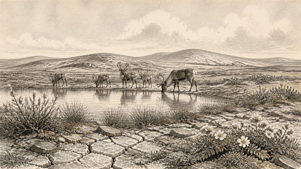
Derryvree was not a woodland lake beside a human village. Its organic sediments contained freshwater mosses and sedges, while plant and insect evidence indicated cold, northern conditions. The original investigators described an open tundra vegetation and a periglacial climate: a landscape repeatedly shaped by freezing and thawing, with little or no tree cover. Such a setting may have included shallow pools, wet sedge-rich margins, low herbaceous vegetation and exposed mineral ground. Plants such as mountain-avens, dwarf willow, clubmosses and aquatic species are part of the wider fossil picture recovered from the deposit; they indicate that even severe landscapes contained distinct wet and dry habitats.
This was an environment of short growing seasons rather than lifelessness. Meltwater, groundwater and local drainage could sustain marshy pockets among otherwise open terrain. Insects are particularly informative because their ecological tolerances help reconstruct summer warmth, winter severity and the character of local vegetation. Yet the evidence is local. It supports a cold freshwater mosaic at Derryvree, not a uniform reconstruction of every valley in Ireland. Hills, coastlands, limestone basins and uplands would have responded differently to snow cover, wind, drainage and the advancing or retreating margins of ice.
An Island Not Yet Engulfed
The broader geological evidence confirms that Ireland’s last glaciation did not arrive everywhere at once. Comparable Middle Midlandian deposits at Hollymount and Greenagho in Fermanagh record cold but non-glacial intervals. A synthesis of dated deposits concludes that north-central Ireland was ice-free until at least about 34,000 years ago, before the major expansion of the last Irish Ice Sheet. In the west, dated marine evidence from Donegal Bay also indicates open water through much of the preceding period. Around the chronological point represented by 31,108 BCE, Ireland was therefore in a volatile interval: cold, open and increasingly vulnerable to renewed glaciation, but not simply an island buried beneath a single uninterrupted ice mass.
The important regional change lay ahead. Research on the last British–Irish Ice Sheet indicates a long build-up from roughly 34,000 years ago, with major expansion continuing towards the global Last Glacial Maximum, conventionally placed around 26,000–19,000 years ago. Evidence from southern Ireland shows that inland ice did not cross the south coast until after about 24,000 calendar years BP. These are continent-scale processes and long spans of time, not a prediction that an ice front moved across a particular Irish district in 31,108 BCE. They do explain why Derryvree’s organic bed was eventually sealed beneath later till.
Animals of the Open Country
Irish cave collections demonstrate that a substantially richer mammal fauna reached the island intermittently between at least about 45,000 and 20,000 years ago. Castlepook Cave, near Doneraile in County Cork, is especially important. Its long-accumulated Pleistocene assemblage includes evidence for reindeer, woolly mammoth, giant deer, brown bear, wolf, Arctic fox, mountain hare, lemmings and spotted hyaena. It would be wrong to place all these animals together at Castlepook in this one calendrical year: cave deposits can combine remains accumulated over many millennia, and carnivores, water movement and early excavation disturbed their contexts.
Even so, the fauna makes the wider ecological point clear. Ireland could support large herbivores and predators in suitable ice-age intervals. Reindeer, mammoth and giant deer imply extensive feeding grounds, while hyaena and wolf remind us that carcasses and caves were not exclusively human spaces. The island’s sea crossings were also different in scale from those of today because global sea levels were lower, exposing larger areas of the continental shelf. Lower sea level did not automatically create a proven land bridge to Ireland, however. Routes available to animals or people remain a matter for reconstruction, not an excuse to assume effortless movement.
The Castlepook Human Question
One object makes this period exceptionally significant for Irish archaeology: a reindeer femur from Castlepook bearing a deep surface mark interpreted by zooarchaeologist Ruth Carden as a cut or chop made with a stone tool during carcass processing. Public reporting and County Cork heritage material have described the bone as around 33,000 years old, broadly close to the chronological setting of this article. If the mark is confirmed as human-made and contemporary with the animal’s death, it would be evidence that people handled a reindeer in Ireland during the Upper Palaeolithic—far earlier than the better-established terminal-Pleistocene human evidence from Alice and Gwendoline Cave in County Clare.
The limits of that claim must be stated plainly. The femur is from an old cave collection, not a modern excavation of a sealed occupation floor accompanied by a stone-tool assemblage, hearth, shelter, burial or repeated camp deposits. A radiocarbon result dates the animal’s death, while identifying a cut mark is a separate taphonomic judgement. Nor can the bone establish whether people hunted the animal, scavenged it, removed meat, hide or sinew, or processed it elsewhere before the limb entered the cave. Recent investigations at Castlepook have sought surviving Pleistocene deposits, but reported no cultural artefacts in the 2022 excavation.
What Cannot Be Claimed
There is no evidence from Ireland around this time for political units, rulers, warfare, diplomacy, named peoples, language or ethnic identity. There is likewise no Irish evidence for farming, herding, cultivated crops, houses, villages, monuments, formal exchange networks, graves, art or religious ceremonies of this antiquity. It is possible that a humanly modified reindeer bone records a brief visit by a small, mobile party equipped with a sharp stone edge. That is an interpretation bounded by the evidence, not proof of permanent settlement.
Accordingly, “society” and “economy” can only be approached at their smallest credible scale. If Castlepook’s mark is anthropogenic, it implies practical knowledge of carcass processing and access to lithic technology. It does not reveal family structure, leadership, trade or belief. “Conflict” is represented only by ecological realities—predation, competition for shelter and exposure to severe weather—not demonstrable warfare. “Learning” is visible indirectly in the modern scientific work required to read this landscape: stratigraphy, palaeobotany, entomology, zooarchaeology, radiocarbon dating and the re-examination of museum collections.
A Landscape Before Later Ireland
The principal development around 31,108 BCE was environmental rather than political. Ireland retained ice-free, tundra-like habitats during a changing phase of the last glacial cycle. At Derryvree, sedges, mosses, insects and freshwater sediments preserve a rare local record of those conditions. Across the island, caves and fossils show that cold-adapted animals could reach and inhabit suitable terrain. Castlepook’s marked reindeer femur raises the serious possibility that people did too. But it remains a question anchored in one bone, not a licence to invent a populated prehistoric Ireland. The history here is deep, fragmentary and compelling precisely because its surviving witnesses demand restraint.
Primary Sources
- A Middle Midlandian Freshwater Series at Derryvree, Maguiresbridge, County Fermanagh, Northern Ireland
- Early Midlandian–Middle Midlandian, Pleistocene, Northern Ireland
- Trimlines, Blockfields and the Vertical Extent of the Last Ice Sheet in Southern Ireland
- Late Pleistocene Chronostratigraphy and Ice Sheet Limits, Southern Ireland
- Last Glacial Maximum Cirque Glaciation in Ireland and Implications for Reconstructions of the Irish Ice Sheet
- Reconstructing the Last Irish Ice Sheet 2: A Geomorphologically-Driven Model of Ice Sheet Growth, Retreat and Dynamics
- Dimensions and Chronology of the Last Ice Sheet in Western Ireland
- Sedimentology and Chronology of the Advance and Retreat of the Last British-Irish Ice Sheet on the Continental Shelf West of Ireland
- Timing and Pace of Ice-Sheet Withdrawal Across the Marine–Terrestrial Transition West of Ireland During the Last Glaciation
- Exploring Controls of the Early and Stepped Deglaciation on the Western Margin of the British-Irish Ice Sheet
- The Irish Quaternary Fauna Project
- New Insights on the Fauna of Ireland’s Younger Dryas and Early Holocene from Alice & Gwendoline Cave
- Ancient DNA Reveals Late Survival of Irish Red Deer and Confirms the Introduction of Red Deer to Ireland
- Archaeological Excavation at Castlepook Cave, Co. Cork, 2022
- The Archaeological Heritage of County Cork
- UCD School of Archaeology Research Day 2022
- The Mesolithic in Ireland: When Was It?
- The IntCal20 Northern Hemisphere Radiocarbon Age Calibration Curve (0–55 cal kBP)
- Pattern and Timing of Retreat of the Last British–Irish Ice Sheet
- Stratigraphic and Palaeo-Geomorphological Evidence for the Glacial-Deglacial History of the Last British-Irish Ice Sheet in the North-Western Irish Sea
