

Castlepook’s Hyena Cache30879 BCE
At 30,879 BCE, Ireland cannot be described through a precise annual record, as dating uncertainties and disturbed deposits require a broad Late Pleistocene interpretation. Derryvree, County Fermanagh, preserves evidence of a cold, largely treeless, wet periglacial landscape with sedges, grasses, mosses, freshwater pools and open ground between glacial advances. Castlepook Cave, County Cork, contains time-averaged remains of mammoth, giant deer, reindeer, bear and hyena, demonstrating intermittent links to wider European fauna. Expanding British–Irish ice later destroyed or buried much evidence. No secure human occupation, tools, polity or culture dates to this period in Ireland; early visits remain conceivable but unproven.
Dateline
“30,879 BCE” is a modern chronological label, not a date that can be recovered from the Irish archaeological record. It corresponds only approximately to 32.8 thousand calendar years before AD 1950. At this depth of time, radiocarbon measurements require calibration, their uncertainties are often wide, and deposits can be disturbed or redeposited. No event, individual or occupation can responsibly be assigned to this particular year. What can be described is Ireland during a broader Late Pleistocene interval, within Marine Isotope Stage 3, as climates fluctuated sharply and the British–Irish Ice Sheet was beginning the expansion that would later transform the island.
A Date Within Ranges
The closest especially informative Irish environmental evidence comes from Derryvree near Maguiresbridge, County Fermanagh. Road works there exposed fine sands, silts and organic material trapped between two tills: deposits left by ice before and after a period when the locality was not ice-covered. The original radiocarbon determination from the organic layer was 30,500 ± 1,100 radiocarbon years BP. That is not equivalent to a calendar date, and recalibration produces a broader, older calendar range rather than a precise historical moment. It nevertheless places the deposit broadly in the same middle-to-late Ice Age world as the requested date.
This distinction matters. A radiocarbon result dates sampled organic material, within stated statistical limits; it does not date every plant, animal or episode represented in a sediment bed. Modern calibration curves have also altered the relationship between radiocarbon and calendar time, particularly beyond 30,000 years ago. Ireland around 30,879 BCE must therefore be approached as a long environmental interval, probably spanning centuries or millennia, rather than as an annual chronicle.
Derryvree’s Cold Wetland
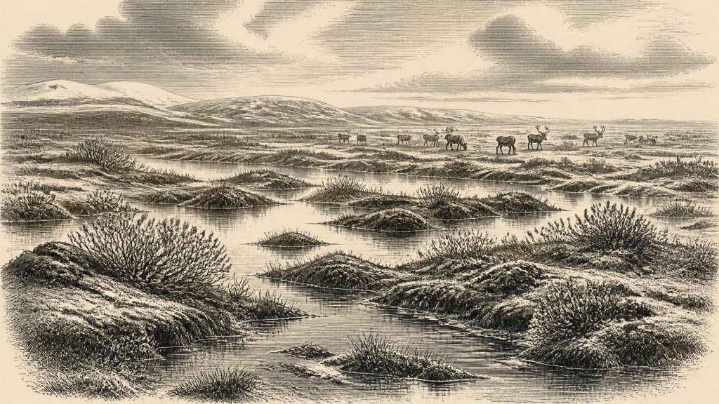
The Derryvree sequence is among the rare surviving windows onto pre-Last Glacial Maximum Ireland. Its pollen, plant macrofossils, mosses and insect remains indicate a cold, open, periglacial landscape. Periglacial terrain lay outside glacier ice but was strongly shaped by severe frost, seasonal thaw, unstable ground and a short growing season. The evidence points to wet hollows, shallow freshwater, sedge-rich margins, mossy ground and exposed mineral soils rather than the dense temperate woodland that developed much later in the Holocene.
Grasses, sedges, juniper and herbs are characteristic components of the recorded flora. Mosses and aquatic or wetland plants add important local detail: Derryvree was not simply a dry, uniform ‘tundra’ but a patchwork of open ground and waterlogged basins. A fossil seed of bogbean, Menyanthes trifoliata, is especially useful evidence for freshwater or wet margins. The insect evidence similarly supports a cold muskeg-like environment with open pools and plentiful plant material. These are direct observations from a specific Fermanagh locality; they do not permit a detailed map of every Irish valley.
Nor should sparse tree pollen be treated as proof that woods stood nearby. Pollen can travel considerable distances, and older grains may be reworked. The strongest conclusion is that the local landscape was largely treeless or nearly treeless, cold and wet. In a place repeatedly affected by glacial advance, survival itself was precarious: vegetation occupied available ground during an interval between episodes of ice movement.
The Ice Sheet Was Building
At roughly 32.8 thousand calendar years ago, Ireland was not yet necessarily in the fully ice-covered condition of the later Last Glacial Maximum. Reconstructions differ over the timing and extent of early advances, and ice cover was neither synchronous nor uniform across the island and surrounding shelf. A widely used working model places the major build-up of the British–Irish Ice Sheet after about 35–32 thousand years ago, while shelf-edge advances west and north-west of Ireland are generally dated later, around 29–27 thousand calibrated years BP. Maximum coverage of Ireland and its continental shelf belongs principally to about 27,000–23,000 calibrated BP.
Thus Derryvree’s inter-till wetland records neither an ice-free Ireland nor a permanent refuge. It records one local interruption in a longer history of glaciation. Renewed ice later buried the organic sediments beneath till and reshaped the region’s landforms. This process helps explain why evidence from this period is so scarce. Glaciers eroded surfaces, mixed deposits, carried material away and concealed earlier landscapes under fresh sediment. The absence of sites is consequently not simple proof that no animals or people ever entered Ireland; equally, scarcity cannot be converted into positive evidence for a population.
Castlepook’s Time-Averaged Fauna
County Cork’s Castlepook Cave, also known as Mammoth Cave or Doneraile Cave, offers a complementary record. It is Ireland’s richest known cave archive for vertebrate life before the Last Glacial Maximum. More than 2,000 bones recovered from its passages represent a long and complicated accumulation, not one living animal community frozen in time. The cave contains remains attributed to woolly mammoth, giant deer, reindeer, brown bear and spotted hyena, while later cold-stage deposits produced Arctic fox, wolf and lemmings.
The presence of spotted hyena is particularly revealing. Hyenas could carry bones into a cave, gnaw them, scatter them and accumulate remains over repeated use of a den or shelter. Water movement and early twentieth-century excavation have added further disturbance. Castlepook should therefore be understood as a time-averaged bone repository rather than a straightforward hunting camp or a census of one year’s fauna. The cave’s old conventional radiocarbon series spans a very long period, while improved pretreatment and redating have shown that several earlier determinations underestimated the age of some specimens. Recent scholarship consequently urges caution in connecting individual bones to one another or to a narrow climatic phase.
Even so, the assemblage establishes an important fact about Ice Age Ireland. Before the maximum glaciation, the island was periodically part of a wider north-west European faunal zone capable of supporting large grazing and browsing mammals, their predators and scavengers. Reindeer suggest open, cold-country habitats; mammoth and giant deer show that the later Irish landscape was not always defined by the relatively restricted animal communities familiar from historic times. But animal bones do not demonstrate that all these species lived together at Castlepook in 30,879 BCE, or that their ranges remained constant as climate deteriorated.
People: Possibility Is Not Proof
There is no secure settlement, hearth, stone-tool assemblage, burial, house floor or artwork in Ireland that can be assigned to around 30,879 BCE. The island’s earliest firmly supported evidence for human presence is much later, in the terminal Pleistocene, including a butchered brown-bear bone from Alice and Gwendoline Cave in County Clare dated to roughly 12,810–12,590 calibrated BP. That find cannot be projected backwards by twenty millennia.
A reindeer femur from Castlepook has been proposed as bearing a possible stone-tool cut mark, and it has understandably prompted discussion of much earlier human activity. The claim remains insufficient to establish an Irish Upper Palaeolithic population at this date. A single modified bone, particularly from a disturbed cave assemblage, cannot prove continuous occupation, group size, seasonal routes, language or ancestry. Nor has a contemporary toolkit been recovered to identify the material, technology or makers of any putative implement. The responsible conclusion is that a very brief human visit is conceivable, not demonstrated.
No Polities, No Recorded Culture
For this reason, the familiar headings of political affairs, diplomacy and warfare have no evidential content here. No Irish kingdom, chiefdom, territory, alliance or conflict can be identified. There is likewise no basis for describing an economy of hunting, exchange or trade, though any human visitors—if there were any—would have had to navigate a demanding cold environment and obtain food, fuel and raw materials from it. Lower sea levels altered coastlines, but the changing geography of the Irish Sea does not by itself establish a land route or a human crossing at this time.
Religion, art, oral tradition and learning also remain beyond recovery for Ireland around this date. It would be misleading to supply them from the better-known Upper Palaeolithic societies of continental Europe or Britain. Comparable hunter-gatherer communities elsewhere show what was possible, not what is evidenced on this island. The archaeological record preserves an environment and an animal world, not an identifiable Irish society.
An Island Before Erasure
The most significant development near this notional year was environmental instability. Cold wetlands endured in Fermanagh during an interval between glacial advances. In southern Ireland, caves accumulated bones from a richer and more varied Pleistocene fauna than later Ireland would possess. Across the wider region, ice was expanding towards its maximum extent, eventually scouring, burying and fragmenting much of the evidence that might otherwise have survived.
Derryvree’s silts and Castlepook’s bones therefore provide a more truthful account than a fabricated episode ever could. They show an Irish landscape of frosted ground, shallow water, open vegetation and mobile animals, increasingly vulnerable to renewed glaciation. They cannot tell us what happened in one calendar year, but they illuminate the fragile ecological setting from which Ireland’s deepest recoverable past must be reconstructed.
Primary Sources
- A Middle Midlandian Freshwater Series at Derryvree, Maguiresbridge, County Fermanagh, Northern Ireland
- The Irish Quaternary Fauna Project
- A Reconsideration of the Radiocarbon Dating of the Marine Isotope Stage 3 Fauna from Southern Ireland
- Castlepook Cave
- New Insights on the Fauna of Ireland’s Younger Dryas and Early Holocene from Alice & Gwendoline Cave
- 2022:564 – Castlepook Cave, Castlepook South, Cork
- Irish Caves Database: Mammoth Cave
- Extent and Timing of the Last Glacial Maximum (LGM) in Britain and Ireland: A Review
- Growth and Retreat of the Last British–Irish Ice Sheet, 31,000 to 15,000 Years Ago: The BRITICE-CHRONO Reconstruction
- Pattern and Timing of Retreat of the Last British-Irish Ice Sheet
- Marine Geophysical Evidence for Late Pleistocene Ice Sheet Extent and Recession off Northwest Ireland
- Dimensions and Chronology of the Last Ice Sheet in Western Ireland
- Trimlines, Blockfields and the Vertical Extent of the Last Ice Sheet in Southern Ireland
- The Timing and Magnitude of the British–Irish Ice Sheet Between Marine Isotope Stages 5d and 2
- Stratigraphic and Palaeo-Geomorphological Evidence for the Glacial-Deglacial History of the Last British-Irish Ice Sheet in the North-Western Irish Sea
- Exploring Controls of the Early and Stepped Deglaciation on the Western Margin of the British Irish Ice Sheet
- Deglaciation Chronology of the Donegal Ice Centre, North-West Ireland
- Ireland: Submerged Prehistoric Sites and Landscapes
- The IntCal20 Northern Hemisphere Radiocarbon Age Calibration Curve (0–55 cal kBP)
- A Stratigraphic Framework for Abrupt Climatic Changes During the Last Glacial Period Based on Three Synchronized Greenland Ice-Core Records
- NGRIP: GICC05 Time Scale and δ18O Values
- Quaternary of Fermanagh: Field Guide
- Figure 6: The Subdivision of the Quaternary Period in Ireland
- Menyanthes trifoliata in Fermanagh: Fossil Record
- Middle Midlandian Interstadial Deposits at Greenagho, Near Belcoo, County Fermanagh, Northern Ireland