
Maguiresbridge Bogbean Seed30832 BCE
Labelled 30,832 BCE, this period cannot be reconstructed as a precise Irish year, but falls within unstable MIS 3 conditions. Derryvree deposits near Maguiresbridge, Fermanagh, broadly dated to 36,900–31,700 calibrated years BP, record freshwater organic sediments between glacial tills, showing episodic ice cover rather than continuous glaciation. Fossils reveal a cold, treeless wetland of sedges, mosses, bogbean and low shrubs. Southern cave finds indicate cold-adapted mammals, although disturbed deposits prevent firm contemporaneity. A possibly butchered reindeer bone suggests brief human presence, not settlement. No political, cultural or trade history is recoverable; evidence chiefly illuminates fragile Ice Age environments in Ireland.
Dateline
30,832 BCE is a modern chronological label, not a year that can be recovered from an Irish calendar or historical record. It corresponds to roughly 32,780 years before the conventional radiocarbon ‘present’ of AD 1950, but no written source, settlement sequence or securely dated event permits year-by-year history at this depth of time. The responsible frame is later Marine Isotope Stage 3 (MIS 3), a climatically unstable part of the Last Glacial Period. Ireland’s evidence is fragmentary: sediments, pollen, plant remains, insects, animal bones and traces of ice. These can illuminate environments and possibilities, but not name rulers, communities or incidents in a particular season.
The requested date falls broadly within the age range often associated with the Derryvree freshwater deposits near Maguiresbridge, County Fermanagh. Yet it must not be treated as the precise date of that deposit. The original radiocarbon determination from its organic sediments was 30,500 +1,170/−1,030 radiocarbon years BP. Radiocarbon years differ from calendar years because atmospheric carbon-14 has varied over time. Calibration converts such determinations into probability ranges, rather than a single exact answer; published discussion places Derryvree broadly at c. 36,900–31,700 calibrated years BP. Thus 30,832 BCE lies within a useful archaeological window, not at a demonstrable moment in the life of one pond, animal or human group.
Between Ice Advances
Derryvree is important because a road cutting through a drumlin exposed fine sands, freshwater silts and organic layers trapped between two thick tills. Till is the unsorted debris deposited by glacier ice. The stratigraphy establishes a sequence: glacial ice had affected the locality; an interval followed in which freshwater and organic sediments accumulated; then later ice overrode or approached the area sufficiently to leave the upper till. It is powerful evidence against a simplistic picture of Ireland as continuously buried beneath ice throughout the last cold stage.
It does not, however, prove that all Ireland was ice-free in 30,832 BCE. A buried wetland in Fermanagh records conditions in and around that basin. Other parts of the island could have been colder, drier, more exposed, occupied by local ice or affected by changing ice margins. Recent work on the British–Irish Ice Sheet emphasises both the reality of pre-Last Glacial Maximum glaciation and the difficulty of reconstructing its precise extent before about 30,000 years ago. During MIS 3, ice masses advanced and retreated dynamically. The more securely reconstructed local Last Glacial Maximum came later, broadly c. 27,000–23,000 years BP in Ireland.
A Treeless Wetland Landscape
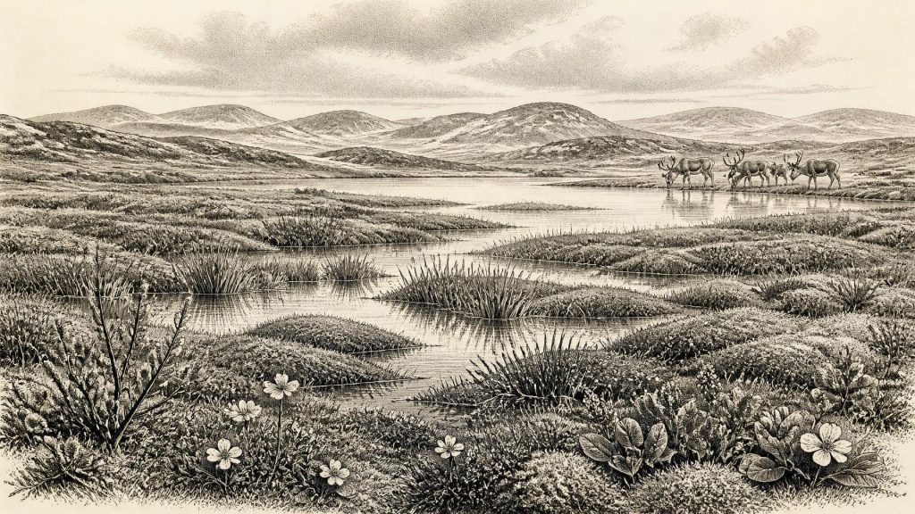
The Derryvree fossils give the closest available Irish view of the environment around this broad period. They indicate cold, open country rather than the familiar wooded Ireland of later millennia. Sedges, grasses, mosses and herb-rich vegetation occupied saturated ground around shallow water. Fossil evidence includes bogbean (Menyanthes trifoliata), alternate water-milfoil, mountain-avens, dwarf willow and lesser clubmoss. These plants point to a mosaic of pools, muddy margins, mossy ground, low vegetation and exposed mineral soil. Fossil insects reinforce the interpretation of a severe northern climate.
‘Tundra’ is an appropriate shorthand if used carefully. It conveys low, largely treeless vegetation and long, cold winters, but Derryvree was not a uniform plain. The waterlogged organic material suggests a muskeg-like patchwork: shallow open water, sedge beds, moss cover and seasonally frozen or saturated ground. Juniper and sparse shrubs may have occurred locally, while occasional tree pollen need not show that trees grew nearby; wind can carry pollen far, and older material can be redeposited. The direct evidence supports a periglacial freshwater landscape in Fermanagh, not a map of every Irish valley.
Animals at the Atlantic Edge
Southern Irish caves add a complementary, though less neatly dated, record of animal life. Castlepook Cave near Doneraile in County Cork has produced remains attributed to reindeer, woolly mammoth, giant deer, brown bear, wolf, foxes, mountain hare, lemmings and spotted hyaena. Such a fauna shows that Ireland was accessible to cold-adapted and open-country mammals during parts of MIS 3. Reindeer and lemmings fit the severe northern setting indicated at Derryvree; mammoth and giant deer evoke a wider mosaic of grassland, herbaceous vegetation and seasonal movement.
But cave assemblages demand caution. Castlepook’s bones were excavated mainly in the late nineteenth and early twentieth centuries, from deposits altered by water movement, animal activity and later disturbance. Some animals may have fallen into cavities; bears and hyaenas may have used caves as dens; bones could be transported or re-sorted. Modern redating has also shown that several older determinations from southern Irish caves understated the age of their specimens. The assemblage therefore demonstrates that these species reached Ireland at different points in MIS 3; it cannot safely establish that every species lived together in one valley, still less in 30,832 BCE.
The Human Question
Claims for people in Ireland at this time remain tantalising but limited. A reindeer femur from Castlepook has been reported as bearing a sharp mark interpreted as stone-tool butchery, and has been publicly associated with an age of roughly 33,000 radiocarbon years BP. If the mark is confirmed as anthropogenic, it would indicate that someone processed a reindeer on the island during the Upper Palaeolithic. That would be profoundly important. Yet a single bone from an old, disturbed cave collection does not demonstrate a settled population, a camp, a hunting territory or continuity with later inhabitants.
There is no securely associated hearth, stone-tool assemblage, built shelter, burial, human skeleton, artwork or repeated occupation surface of this age in Ireland. Nor does a radiocarbon date on an animal bone automatically date a surface modification to a particular day or year. The evidence is best described as a possible brief human incursion, rather than proof of permanent habitation. The earliest published direct evidence for human activity regarded as secure remains much later: a cut-marked brown-bear patella from Alice and Gwendoline Cave, County Clare, dated to c. 12,810–12,590 calibrated years BP.
No Polities, No Trade Network
Accordingly, political affairs, diplomacy, formal warfare and religion cannot be reconstructed for Ireland in this period. There are no named peoples, leaders, monuments, graves or ritual deposits. If people did visit, they would have belonged to mobile Upper Palaeolithic hunter-gatherer worlds known elsewhere in north-west Europe, but importing a continental culture name, social hierarchy or belief system into Ireland would exceed the evidence. Hunting reindeer or exploiting carcasses is plausible only as an interpretation of the disputed Castlepook bone; it is not a documented Irish economy.
Nor is there evidence for trade. At lowered sea levels the geography of the Irish Sea region differed greatly from today, while ice, changing coastlines and later marine inundation complicate any account of routes. Animal dispersal proves that connections or crossings were possible at some times, not whether people followed a particular track, used boats, crossed ice or maintained regular contact. Later glaciation and sea-level rise probably removed or buried much evidence from coasts, river corridors and lowlands, making absence difficult to interpret.
A Fragile Record
The significance of 30,832 BCE is therefore environmental rather than eventful. Ireland was part of a changing north-west European Ice Age world: cold, seasonally harsh and regionally varied; inhabited by plants and animals adapted to open ground and freshwater margins; and repeatedly reshaped by ice. At Derryvree, a bogbean seed and associated wetland fossils preserve a rare interval when life occupied ground bracketed by glacial deposits. At Castlepook, bones record an intermittently rich but chronologically mixed mammal fauna. Together they reveal an Ireland with living landscapes long before farming, monuments, written memory or demonstrable permanent settlement—while also defining the limits of what can honestly be claimed.
Primary Sources
- A Middle Midlandian Freshwater Series at Derryvree, Maguiresbridge, County Fermanagh, Northern Ireland
- The Irish Quaternary Fauna Project
- Pleistocene Vertebrates in the British Isles
- A Reconsideration of the Radiocarbon Dating of the Marine Isotope Stage 3 Fauna from Southern Ireland
- The Timing and Magnitude of the British–Irish Ice Sheet Between Marine Isotope Stages 5d and 2
- New Data for the Last Glacial Maximum in Great Britain and Ireland
- Timing and Pace of Ice-Sheet Withdrawal Across the Marine–Terrestrial Transition West of Ireland During the Last Glaciation
- Glacial Geomorphology in the Wicklow Mountains, Ireland
- Dimensions and Chronology of the Last Ice Sheet in Western Ireland
- First Evidence of a Late Upper Palaeolithic Human Presence in Ireland
- New Insights on the Fauna of Ireland's Younger Dryas and Early Holocene from Alice & Gwendoline Cave
- The IntCal20 Northern Hemisphere Radiocarbon Age Calibration Curve (0–55 cal kBP)
- Prehistoric Details
- Heritage Artefacts of County Cork
- Archaeological Heritage of County Cork
- Figure 6: The Subdivision of the Quaternary Period in Ireland
- Menyanthes trifoliata L.
- Salix herbacea L.
- Dryas octopetala L.
- Myriophyllum alterniflorum DC.
- 32564: Castlepook Cave, Castlepook, Co. Cork
- Mammoth Cave
