

Fermanagh’s Drumlin Roadworks30366 BCE
At 30,366 BCE, Ireland’s history can only be reconstructed from uncertain environmental evidence, not records or dated events. Derryvree, County Fermanagh, revealed freshwater silts between glacial tills, preserving plants, insects and aquatic remains from a treeless, cold, waterlogged landscape of grasses, sedges, juniper and mosses. The deposits demonstrate repeated local ice advance and retreat, while wider reconstructions indicate expanding but incompletely mapped British–Irish ice. Cave fauna from Castlepook, County Cork, includes cold-adapted mammals, although bones span long periods. A possibly cut-marked reindeer femur suggests, but does not prove, human presence. No secure settlement evidence exists; environmental change dominates this period.
Dateline
30,366 BCE is a modern chronological label, not a date that can be recovered from an Irish calendar, document or human memory. Around 32,316 years before 1950, Ireland lay within the Late Pleistocene, in Marine Isotope Stage 3, during a long glacial age marked by sharp climatic swings and the growing power of the British–Irish Ice Sheet. Modern calendar-year precision is not available at this depth of time. The most responsible account of Ireland at this point is therefore not a narrative of events in a single year, but a reconstruction from sediments, fossil plants, insects, animal bones and radiocarbon measurements with substantial uncertainties.
A Date Without a Diary
Nothing supports the naming of a ruler, tribe, settlement, battle or diplomatic encounter in Ireland in 30,366 BCE. There were no written records, no states and no known monuments of this age on the island. Even the existence of people in Ireland at precisely this stage is unproven. The evidence is geographically patchy and dated at resolutions measured in centuries or millennia rather than days, months or individual years. It is essential, too, not to treat a radiocarbon age as a calendar age: conventional radiocarbon years must be calibrated against changing atmospheric carbon levels, and a single measurement produces a probability range rather than an exact historical moment.
One of the most illuminating Irish records comes from Derryvree, near Maguiresbridge in County Fermanagh. Roadworks in 1969 cut through a drumlin and revealed organic freshwater silts and fine sands caught between two thick sheets of glacial till. The sequence was a rare survival: a wetland landscape existed after one episode of ice advance and before another covered it. Organic material from the deposit produced the conventional radiocarbon determination Birm-166, 30,500 years BP, with an uncertainty of +1,170 and −1,030 years. That is a radiocarbon measurement, not a claim that the wetland can be placed in 30,366 BCE. Calibration and the measurement’s uncertainty place its actual calendar age appreciably earlier than the numbered year considered here.
Yet Derryvree remains directly relevant. It records the sort of cold-stage Irish environment that formed during the wider climatic deterioration leading towards extensive glaciation. It also demonstrates why a neat, island-wide chronology is impossible. A deposit in Fermanagh may represent conditions in its local basin over a particular span of time; it cannot by itself describe every valley, coast or upland in Ireland, still less one exact year.
Wet Ground Between Ice Advances
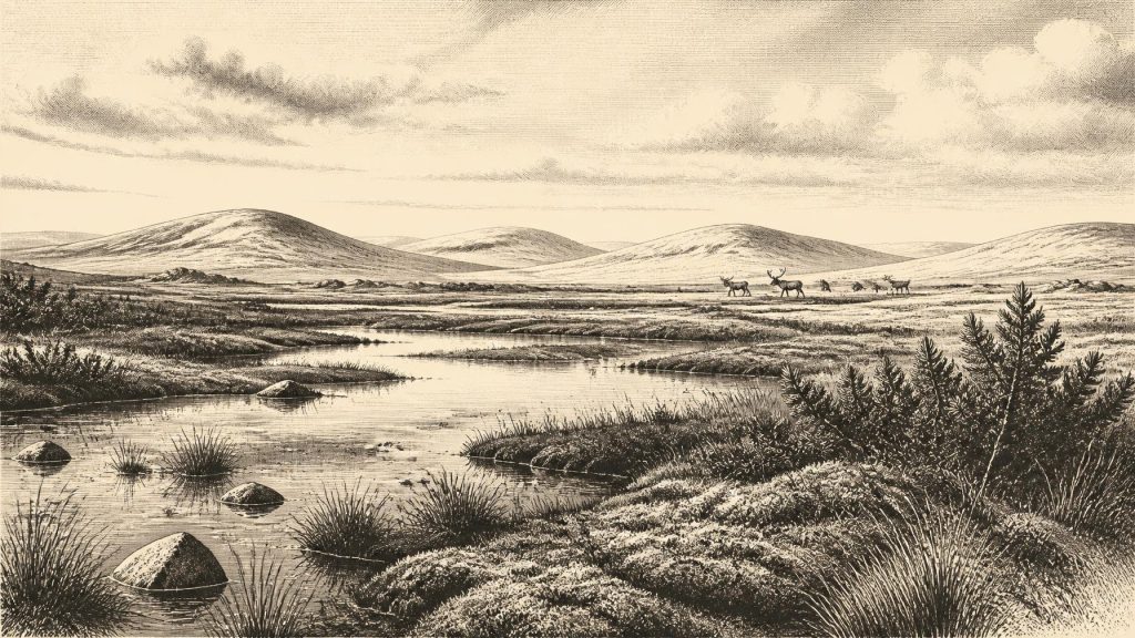
The Derryvree silts preserved plant and animal remains of a severe, treeless landscape. Grasses and sedges were important, alongside juniper and herbaceous plants. Mosses, aquatic organisms and insects point to a waterlogged mosaic rather than a uniform white wilderness: shallow pools, saturated ground, mossy margins and patches of open vegetation lay within a periglacial setting. The word muskeg, used by researchers for this kind of boggy, cold-climate terrain, conveys a landscape in which standing water and peat-forming vegetation could persist despite harsh winters.
This was not forested Ireland. There is no basis for imagining oak woods, settled clearings or a familiar rural countryside. Short summer growing seasons, frost action, sparse cover and exposed ground would have shaped the local environment. The flora is evidence for particular habitats and climate conditions; the richer visual reconstruction of a tundra wetland is an interpretation based on how those organisms live together. The distinction matters because pollen, seeds and insect fragments do not yield a complete view of vegetation density, annual weather or the duration of snow cover.
The drumlin itself tells a larger environmental story. Its lower till had already been laid down by glacier ice. The freshwater sediments accumulated during an interval when the locality was not overridden by ice, and the upper till records a subsequent return of glacial conditions. Such stratigraphy makes Derryvree a witness to repeated advance and retreat, not evidence for a simple, steadily worsening freeze. Across the Irish region, ice behaviour was asynchronous: different ice centres, sea-fed margins and uplands did not necessarily grow or retreat together.
The Ice Sheet in Formation
Recent reconstructions of the British–Irish Ice Sheet begin at about 31,000 years ago because evidence for earlier margins is especially sparse. They indicate that, in the early part of this broad interval, ice was building over northern Ireland and elsewhere in Britain while separate ice caps existed in the south-west of Ireland. By about 30,000 years ago, the reconstruction depicts expansion across northern and central Ireland, though the dates and positions carry wide uncertainty. It would be misleading to turn that model into a statement that all of Ireland was ice-covered in 30,366 BCE. The exact extent at this notional date remains unresolved.
What can be said is that Ireland was approaching a profound regional transformation. Over the following millennia, the British–Irish Ice Sheet expanded dramatically; by roughly 28,000 years ago, reconstructions show nearly all of Ireland beneath ice. Glaciers would scour bedrock, move enormous quantities of sediment and reshape drainage. Much of the physical evidence for any earlier ground surface, plant community or human visit was consequently destroyed, buried or redeposited. This is a central reason why the archaeological record for this period is so thin: absence of sites is partly an absence created by later ice, not a simple demonstration that no one ever came.
Animals in a Cold Landscape
Cave deposits, particularly at Castlepook Cave or Mammoth Cave near Doneraile in County Cork, offer another window onto Ice Age Ireland. Collections from the cave include remains attributed to woolly mammoth, giant deer, reindeer, brown bear, wolf, Arctic fox, lemmings and spotted hyaena. They do not represent one simultaneous animal community or a single landscape. The bones accumulated over a long period, and the cave’s sediments and older collections have been disturbed by water, carnivores, excavation and curation history. Nonetheless, direct radiocarbon dating shows that Castlepook preserves fauna extending deep into Marine Isotope Stage 3.
The assemblage indicates that cold-adapted mammals could use parts of Ireland before the Last Glacial Maximum. Reindeer and lemmings are especially evocative of open, cold country, while hyaena and wolf remind us that animal life included predators and scavengers as well as grazing herds. Mammoths and giant deer must not be imagined as permanent fixtures everywhere on the island; cave finds establish presence in broad periods, not local population numbers or seasonal movements. Nor can animal bones alone establish where people travelled, hunted or lived.
One Castlepook reindeer femur has renewed the question of human presence. Zooarchaeologist Ruth Carden identified a deep linear mark that has been interpreted as damage made by a sharp stone tool during processing of fresh bone. County Cork heritage material presents the specimen as roughly 31,000 BC, while wider scientific work stresses the complications of old cave collections and dating. If the mark is genuinely anthropogenic, and if it belongs to the bone’s Ice Age history, it would be extraordinary evidence that a person or small party handled a reindeer in Ireland far earlier than the securely evidenced terminal-Pleistocene human activity at Alice and Gwendoline Cave, County Clare.
That conditional language is indispensable. The reindeer bone does not demonstrate a settlement at Castlepook, a hunting camp in Cork, a resident population, an ethnic identity, or an unbroken human occupation of Ireland. It cannot tell us whether people killed the animal, encountered a carcass, removed meat or sinew, or processed it elsewhere before the bone reached the cave. No securely associated hearth, house floor, tool assemblage, burial, artwork or human skeleton of comparable age has been published from Ireland. The National Museum of Ireland accordingly continues to describe unequivocal Palaeolithic evidence for people in Ireland as absent.
Society Beyond Recovery
Because no settlement evidence can be assigned confidently to around 30,366 BCE, the usual headings of political affairs, warfare, diplomacy, religion, learning, trade and economy cannot be filled responsibly. There were no known Irish polities with which to conduct diplomacy, no evidence for organised conflict, and no evidence for exchange networks reaching the island at this date. Nor is there evidence for houses, clothing, boats, language, kinship rules, ritual places or art. European Upper Palaeolithic communities elsewhere made sophisticated tools, ornaments and images, but those continental and British records cannot simply be imported into Ireland.
If people did make brief visits, their most plausible subsistence context would have involved mobile hunter-gatherer knowledge of cold environments and large mammals. That is an inference from the possible cut-marked femur and the wider European world, not an established description of Irish daily life. It should not be inflated into a story of a reindeer-hunting people crossing a known route, because neither their route nor their duration of stay is demonstrated. Low sea levels altered the shape of coasts and exposed continental shelves, but they did not automatically remove every marine barrier between Ireland and Britain.
The real historical development represented by this distant date is environmental, not political: Ireland was entering the phase in which expanding ice would radically alter its terrain and erase much of its earlier archive. Fermanagh’s buried wetland and Cork’s cave fauna preserve fragments from before that transformation. They show a living but severe landscape of pools, sedges, mosses, sparse tundra vegetation and cold-adapted animals. Their restraint is their value. Rather than supplying an invented episode for a numbered year, they reveal what the evidence can genuinely bear: an Ireland whose history was then written chiefly in ice, mud, bone and seed.
Primary Sources
- Middle Midlandian Freshwater Series at Derryvree, Maguiresbridge, County Fermanagh, Northern Ireland
- Middle Midlandian Freshwater Series at Derryvree, Maguiresbridge, County Fermanagh, Northern Ireland
- Landscapes and Environments of the Last Glacial-Interglacial Transition: A Time of Amazingly Rapid Change in Ireland
- The Irish Quaternary Fauna Project
- A Reconsideration of the Radiocarbon Dating of the Marine Isotope Stage 3 Fauna from Southern Ireland
- Growth and Retreat of the Last British–Irish Ice Sheet, 31,000 to 15,000 Years Ago: the BRITICE-CHRONO Reconstruction
- New Insights on the Fauna of Ireland's Younger Dryas and Early Holocene from Alice & Gwendoline Cave
- New Insights on the Fauna of Ireland's Younger Dryas and Early Holocene from Alice & Gwendoline Cave
- Heritage Artefacts of County Cork
- The Exploration of Castlepook Cave, County Cork, Being the Third Report from the Committee Appointed to Explore Irish Caves
- First Evidence of a Late Upper Palaeolithic Human Presence in Ireland
- First Evidence of a Late Upper Palaeolithic Human Presence in Ireland
- Our Ancient Landscapes: Hunter-Gatherers in Ireland
- Prehistoric Details: Mell Flint Flake
- Stone Age
- The IntCal20 Northern Hemisphere Radiocarbon Age Calibration Curve (0–55 cal kBP)
- The Greenland Ice Core Chronology 2005 (GICC05)
- Data – Ice Samples – Software
- Figure 6.— The Subdivision of the Quaternary Period in Ireland
- Outreach and Education Resources




