

Castlepook’s Unfinished Evidence30363 BCE
30,363 BCE is best understood as a broad, uncertain Late Pleistocene interval within Marine Isotope Stage 3, rather than a recoverable Irish year. Derryvree, County Fermanagh, preserves freshwater sediments between glacial tills, revealing an ice-free episode of periglacial tundra, wetlands, mosses and cold-adapted plants. Southern caves, particularly Castlepook in County Cork, contain remains of mammoth, reindeer, giant deer, predators and other cold-stage fauna, although old excavations limit precision. A marked reindeer bone may indicate human carcass processing, but remains unconfirmed. No evidence supports settled communities, agriculture or political life. Advancing ice later destroyed evidence, leaving a fragmented, ecologically varied record.
Dateline
30,363 BCE is a modern way of naming a point deep in the Late Pleistocene, not a year that can be recovered from Irish archaeological evidence. It corresponds roughly to 32,313 years before the conventional radiocarbon reference year of 1950, but neither people nor landscapes in Ireland can be assigned to that single calendar year. The responsible frame is therefore a broad one: a cold, unstable interval within Marine Isotope Stage 3, before the Last Glacial Maximum. Scientific dates at this depth have substantial uncertainties, and the nearest informative Irish deposits span millennia rather than moments.
The most important evidence is environmental rather than historical in the usual sense. It comes from sediments, fossils, cave deposits and the traces left by advancing and retreating ice. They can tell us something of climate, vegetation, animals and changing land surfaces. They cannot identify a kingdom, a named people, a political frontier, a religion or a settled community in Ireland in 30,363 BCE. Even the question of whether people were present is a cautious one.
A Date Within a Wide Window
The closest Irish chronological anchor is a freshwater deposit exposed at Derryvree, near Maguiresbridge in County Fermanagh. Road works in 1969 cut through a drumlin and revealed organic silts and fine sands trapped between two thick sheets of glacial till. One sample, BIRM-166, returned a conventional radiocarbon age of 30,500 years before present, with a large uncertainty of +1,170 and −1,030 years. Later calibration places the deposit broadly between about 36,900 and 31,700 calibrated years before present. The modern label 30,363 BCE, approximately 32,313 calibrated years before present, falls within that wide range.
This does not mean that the Derryvree wetland existed on a particular day in 30,363 BCE, nor that every part of Ireland looked the same as this Fermanagh locality. It means that the deposit is a valuable window onto an ice-free episode in northern Ireland during the later part of Marine Isotope Stage 3. Its position between tills is particularly important: ice had covered the ground before the organic sediments accumulated, and ice later overran or sealed the landscape again. The record is evidence for repeated environmental change, not for a simple advance from mild conditions to one unbroken ice age.
Modern reconstruction of the British–Irish Ice Sheet reinforces that caution. The ice sheet’s well-resolved major growth phase began later, from roughly 31,000 years ago, before reaching its maximum volume around 23,000 years ago. Earlier phases of glaciation during Marine Isotope Stages 4 and 3 are increasingly recognised, but their size, timing and geographical extent remain less secure. Ireland at this date was therefore a changing regional mosaic: some ground could support periglacial tundra and freshwater habitats, while ice remained close enough for glacial deposits to frame the Derryvree sequence.
Water, Moss and Open Ground
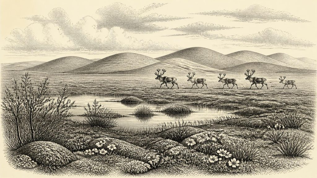
Derryvree offers the clearest picture of an Irish landscape relevant to this date. Its fossil plants, insects and other small remains indicate open tundra vegetation under a periglacial climate: a land shaped by severe frost, seasonal thaw and short growing seasons. The deposit has been interpreted as a muskeg-like wetland, with pools of standing freshwater, abundant plant matter and mossy margins. Fossil remains include aquatic and wetland plants such as bogbean and water-milfoil, alongside cold-adapted terrestrial vegetation including dwarf willow, mountain avens and alpine herbs.
This was not an Irish woodland. Trees were absent from the local record, and the landscape was likely exposed, low-growing and patchy. In summer, sheltered hollows and water margins could become productive islands of sedges, mosses and flowering herbs. In winter, frozen ground, snow cover and persistent winds would have dominated. Mean temperatures cannot be read directly from one buried silt bed, but the combined flora and fauna support an interpretation of harsh winters and a short, cool summer season. The contrast between living water and frozen terrain is central to understanding the setting.
Yet it would be wrong to turn the Derryvree evidence into a map of the entire island. A plant growing in a Fermanagh wetland proves its presence there, not necessarily on the limestone of Cork or the western seaboard. Equally, the survival of freshwater sediment beneath a drumlin is exceptional. Across much of Ireland, later ice erosion removed, mixed or buried older deposits. The patchiness of evidence is itself part of the story: the record survives where geological chance allowed it, not where people or animals were necessarily most numerous.
The Animals of Southern Caves
Caves in southern Ireland provide a complementary, though differently imperfect, archive. Castlepook Cave near Doneraile, County Cork, long known as Mammoth Cave, has yielded remains attributed to a notably rich Ice Age fauna. Work on Irish Quaternary animal collections has documented mammals including reindeer, woolly mammoth, giant deer, brown bear, spotted hyaena, wolf, Arctic fox, mountain hare and lemmings across broadly comparable pre-Last Glacial Maximum intervals. Re-dating has shown that several Castlepook animals are substantially older than early radiocarbon determinations suggested, strengthening the case that parts of Ireland supported diverse cold-stage fauna during Marine Isotope Stage 3.
These animal lists need careful handling. Many bones were recovered during nineteenth- and early twentieth-century cave excavations, before modern standards of stratigraphic recording. Cave deposits can also combine material brought in by carnivores, water, gravity, scavengers and people, sometimes over very long periods. A mammoth bone proves that mammoths reached the wider Irish landscape during an appropriate broad interval; it does not prove that mammoths, reindeer and hyaenas all stood outside the cave together in 30,363 BCE. Nor does a cave assemblage reveal the size of animal herds, their migratory routes or the exact character of the surrounding terrain.
Nevertheless, the environmental implication is substantial. Ireland was not simply a blank sheet beneath permanent ice throughout this part of the last glacial cycle. At intervals, terrestrial habitats existed that could sustain herbivores and the predators or scavengers associated with them. Reindeer were especially suited to open, cold environments, while lemmings and Arctic foxes signal conditions very different from modern Ireland. The evidence also hints at ecological connections across the wider British–Irish region, then altered by lower sea levels and changing ice margins. It does not demonstrate a permanent land bridge, regular animal movement on any particular route, or an inhabited Irish coast.
A Possible Human Trace
Castlepook is important for another reason: a fragment of reindeer femur from the old collection has been reported as bearing a deep mark interpreted as damage made by a sharp stone tool while fresh bone was being processed. Public accounts place the bone at roughly 33,000 years old. If confirmed as an anthropogenic cut mark, it could be evidence that people handled a reindeer carcass in Ireland in the Upper Palaeolithic, tens of millennia before the island’s well-established post-glacial settlement record.
That conditional matters. A single marked bone, especially one from an old and disturbed cave collection, is not equivalent to an excavated camp with securely associated stone tools, hearths, food waste and repeated occupation surfaces. Recent fieldwork at Castlepook has sought surviving Pleistocene deposits, but has also demonstrated how thoroughly earlier excavations removed or disturbed much of the cave fill. At present, the find should be treated as an important claim under investigation rather than proof of a resident population or a continuous Irish Palaeolithic tradition.
Accordingly, it is possible to describe what a brief human visit might have involved only as inference from the bone’s interpretation and wider Upper Palaeolithic practice: carcass processing could have provided meat, marrow, hide, sinew and bone. It cannot responsibly yield a population number, a camp location, a language, kinship system or seasonal schedule. There is no basis for describing political affairs, warfare, diplomacy, religious observance, artistic traditions, teaching or trade in Ireland at this date. The absence of such evidence is not a failure of imagination; it is an essential boundary between archaeological evidence and historical invention.
Before the Great Advance
In economic terms, there was no agriculture, stock-keeping, field system, market or maritime commerce that can be demonstrated for Ireland in this period. If people were present at all, their relationship to the land was one of short-term foraging and hunting within a severe Ice Age environment, not the settled farming world familiar from much later prehistory. Likewise, there are no known houses, burials, monuments, inscriptions or objects of personal display that can be assigned to 30,363 BCE in Ireland.
The most meaningful development was environmental. Wetlands in places such as Derryvree supported a specialised tundra flora; southern cave systems accumulated the fragmentary remains of an Ice Age fauna; and glaciers were part of the landscape’s past and approaching future. Within a few thousand years, the British–Irish Ice Sheet would expand dramatically. Later ice would scour the land, reshape river systems, bury earlier surfaces and greatly reduce the chance that evidence of any people who visited Ireland would survive.
For that reason, Ireland in 30,363 BCE is best understood not as a scene of named events but as a threshold in deep time. The Derryvree silts record life between ice advances. Castlepook’s bones show that large mammals occupied at least some Irish landscapes during the wider period, while one reindeer femur raises the unresolved possibility of human activity. Together they replace the older image of an entirely empty, uniformly frozen island with a more demanding and more interesting picture: a cold, ecologically varied country whose evidence survives in rare, vulnerable fragments.
Primary Sources
- A Middle Midlandian Freshwater Series at Derryvree, Maguiresbridge, County Fermanagh, Northern Ireland
- A reconsideration of the radiocarbon dating of the Marine Isotope Stage 3 fauna from southern Ireland
- The Irish Quaternary Fauna Project
- Growth and retreat of the last British–Irish Ice Sheet, 31,000 to 15,000 years ago: the BRITICE-CHRONO reconstruction
- The timing and magnitude of the British–Irish Ice Sheet between Marine Isotope Stages 5d and 2: implications for glacio-isostatic adjustment, high relative sea levels and ‘giant erratic’ emplacement
- Exploring controls of the early and stepped deglaciation on the western margin of the British Irish Ice Sheet
- Episodic speleothem deposition tracks the terrestrial impact of millennial-scale last glacial climate variability in SW Ireland
- First evidence of a Late Upper Palaeolithic human presence in Ireland
- New insights on the fauna of Ireland’s Younger Dryas and Early Holocene from Alice & Gwendoline Cave
- A stratigraphic framework for abrupt climatic changes during the Last Glacial period based on three synchronized Greenland ice-core records: refining and extending the INTIMATE event stratigraphy
- The IntCal20 Northern Hemisphere radiocarbon age calibration curve (0–55 cal kBP)
- The IntCal20 approach to radiocarbon calibration curve construction: a new methodology using Bayesian splines and errors-in-variables
- IntCal Publications
- Figure 6.— The subdivision of the Quaternary Period in Ireland
- 2022:564 – Castlepook Cave, Castlepook South, Cork
- Archaeology Research Excavation Grant 2022
- Heritage Artefacts of County Cork
- Ireland’s Palaeolithic Archaeology – Fleeting Footprints in a Frozen Land
- Our Ancient Landscapes: Hunter-Gatherers in Ireland
- Data and Maps




