
Maguiresbridge’s Freshwater Flora30351 BCE
Around 30,351 BCE, Ireland’s history is reconstructed from environmental evidence rather than written records. At Derryvree, County Fermanagh, freshwater sediments between two tills indicate a cold, treeless wetland interval between glacial advances. Fossils reveal grasses, sedges, mosses, bogbean and mountain avens within tundra-like terrain. Ireland experienced regional climatic change as the last ice sheet expanded, not uniform conditions. Castlepook Cave, County Cork, preserves remains of reindeer, mammoth, giant deer and predators, though they span different periods. A possibly butchered reindeer bone may indicate Upper Palaeolithic human activity, but no secure settlement evidence exists. Political, cultural and religious life remains unknown.
Dateline
30,351 BCE is a modern calendar label, not a date that can be matched to an event in Ireland with annual precision. No written record, settlement sequence or securely dated human activity allows historians to say what happened in that particular year. The responsible approach is to place it within a much broader Late Pleistocene interval, using calibrated ranges and the physical record of ice, sediments, plants and animals. Around this point, Ireland was in the long Midlandian cold stage, before the fullest extent of the last Irish ice sheet. Its history is not yet a history of named communities or political acts, but of shifting habitats at the edge of a changing North Atlantic world.
Dating an Uncertain Moment
The nearest substantial Irish evidence comes from Derryvree, near Maguiresbridge in County Fermanagh. Roadworks in 1969 cut through a drumlin and exposed an unusually informative sequence: a lower sheet of till, freshwater silts and fine sands with organic material, and a later upper till. Till is the unsorted sediment left directly by glacier ice. The order of these layers establishes an important local sequence: ice had occupied the site; an interval without overriding ice allowed freshwater and wetland sediments to form; then ice returned and sealed the deposit beneath a further till sheet.
An organic sample from this freshwater horizon, BIRM-166, produced a conventional radiocarbon age of 30,500 radiocarbon years before present, with a large uncertainty of roughly a thousand years. Radiocarbon years are not calendar years. Because atmospheric carbon-14 varied through time, dates must be calibrated against independently dated records such as tree rings, corals, cave deposits and lake sequences. Modern calibration therefore converts the Derryvree determination into a broad and irregular calendar range, commonly expressed at approximately 36,900–31,700 calibrated years before present, or about 34,950–29,750 BCE. The label 30,351 BCE falls within this wide interval, near its younger end; it cannot identify a single season, generation or event in the Derryvree deposit.
This uncertainty matters. It would be misleading to picture all Ireland in one uniform condition in 30,351 BCE. The island’s evidence is sparse, sites are separated by considerable distances, and the growth of ice was not perfectly simultaneous in every region. Derryvree demonstrates that its locality had a freshwater interval between two glacial episodes. It does not prove that every coast, valley and upland in Ireland was ice-free at the same moment, nor that the wetland lasted continuously through the whole calibrated range.
A Wetland Between Glaciers
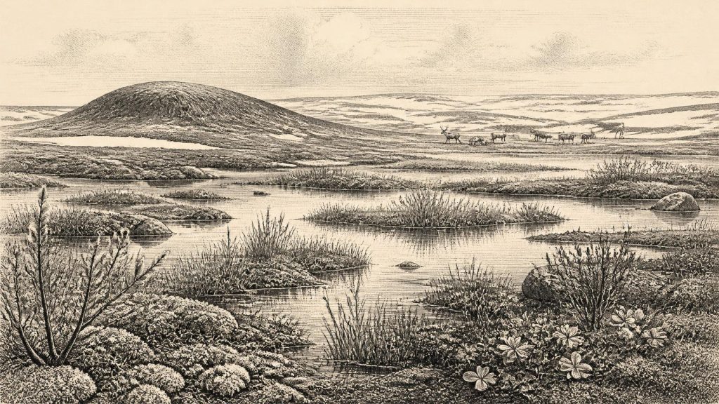
What the Derryvree sediments do reveal is striking. Their pollen, plant macrofossils, mosses and small-animal remains point to a cold, treeless, periglacial environment. “Periglacial” describes ground and climate influenced by nearby or recurrent ice: severe winters, short growing seasons, frost action and limited woodland, without the locality necessarily being covered by glacier ice at the time the sediments accumulated. The landscape was not an empty white expanse. It included freshwater and waterlogged ground within a wider open terrain.
The plant evidence supports a mosaic rather than a simple desert. Grasses and sedges were important, alongside herbs, mosses and low woody plants. Finds recorded from the Derryvree deposit include bogbean (Menyanthes trifoliata), a wetland plant with distinctive seeds, and mountain avens (Dryas octopetala), now familiar in arctic-alpine settings. Freshwater and marginal vegetation indicate standing or slow-moving water, while the broader assemblage points to open tundra-like ground. Such a setting could offer summer forage, sheltered wet hollows and shallow pools, even though it lacked the closed forests associated with later prehistoric Ireland.
The wetland was therefore a living ecological pocket, not merely a geological layer. Aquatic and waterside plants trapped organic matter in silts; mosses and sedges grew where moisture and sediment allowed; insects and small animals responded to the same local conditions. Yet the evidence should not be stretched too far. It does not supply an exact annual temperature, a complete list of all plants across Fermanagh, or a map of every lake and stream. The interpretation of a cold open muskeg or tundra landscape is a synthesis of several fossil signals and the sedimentary setting, not a photograph of a single day.
Ice-Sheet Growth and Regional Change
In the larger chronology, this was a period of climatic deterioration and expanding ice. Reconstructions of the last Irish ice sheet suggest that much of Ireland may have remained ice-free, or at least not continuously overridden, until about 32,000 years ago. Thereafter ice thickened and spread towards the maximum reached later, broadly between 27,000 and 21,000 years ago. These dates are themselves modelled from varied evidence—sub-till organic deposits, landforms, offshore sediments, luminescence dating and exposure dating—and are revised as new work appears. They offer a framework, not a timetable exact enough to assign an ice margin to 30,351 BCE.
Derryvree’s two tills give the changing climate a particularly tangible form. The lower till records an earlier glacial occupation. The organic freshwater bed records an interruption, when the site lay beyond active overriding ice long enough for water and vegetation to establish themselves. The upper till records a later advance. This is strong evidence for local environmental change, but it also warns against treating the Last Glacial Maximum as a single uninterrupted freeze. Ireland’s late Ice Age included advances, retreats, regional contrasts and intervals in which biological communities reoccupied available ground.
Coasts and sea routes were changing as well, though the evidence cannot reconstruct a precise shoreline for this calendar label. Lower global sea levels exposed more continental shelf than exists today, while ice and changing relative sea level reshaped adjacent basins. Ireland nonetheless remained a marginal, water-bounded part of north-west Europe rather than a simple extension of the continent. If people did reach it in this period, their route remains unproved: no securely associated boat, camp, crossing-point or stone-tool trail has yet been found for the Derryvree interval.
Castlepook and the Animal World
County Cork offers a different, complementary archive. Castlepook Cave, near Doneraile, preserved a large assemblage of Pleistocene animal remains accumulated over a long span of time. Its fauna includes reindeer, woolly mammoth, giant deer, brown bear, wolf, Arctic fox, mountain hare, lemmings and spotted hyaena. This is powerful evidence that Ireland at various points before the later maximum supported cold-adapted animals, large herbivores and formidable predators. It also shows that caves can preserve material lost from open-air landscapes.
But Castlepook is not a neatly sealed village floor. Carnivores may have carried prey or scavenged carcass parts into its passages; animals could have died nearby; water could have moved bones; and the principal excavations occurred in the early twentieth century, before modern recovery and recording methods. Recent radiocarbon reassessment has also shown that some older determinations on Irish cave bones need caution. Individual Castlepook remains cover different ages, so the entire species list cannot responsibly be placed in one exact year or assumed to have formed one contemporaneous community.
The cave nevertheless makes the ecological stakes of this period clearer. Reindeer and giant deer depended on vegetation; carnivores and scavengers depended in turn on herbivores and carrion. Seasonal movement, snowfall, shelter and access to water would have structured animal life. This food web is the closest thing the evidence provides to an economy in Ireland at the time: the natural circulation of plant growth, grazing, predation and scavenging. There is no evidence for farming, herding, fields, metalworking, pottery, permanent villages or regular trade within Ireland.
The Human Question
Castlepook also contains the most provocative clue to possible human activity in very early Ireland: a reindeer femur bearing a deep incision interpreted by some researchers as a fresh-bone cut made with a sharp stone tool during butchery. The bone has been reported as about 33,000 years old, broadly close to the environmental interval considered here. If the mark is confirmed as human modification and its age and association are securely established, it would show that at least one person handled a reindeer carcass in Ireland during the Upper Palaeolithic.
That conditional language is essential. The object is not accompanied by a securely associated hearth, lithic assemblage, occupation surface, dwelling, burial or artwork. Nor does one marked bone establish a resident population, a hunting territory, family groups or continuous settlement. It may point to a brief visit, a small mobile party or an episode still impossible to characterise. Ongoing excavation at Castlepook seeks intact deposits, stratified fauna and the kinds of artefacts that could test the interpretation more firmly. For now, possible human presence is an important research question, not a settled narrative of colonisation.
No Kingdoms, No Recorded Beliefs
Accordingly, political affairs, warfare and diplomacy cannot be recovered for Ireland around 30,351 BCE. There are no rulers, territories, treaties, fortifications or conflicts in the evidence. Equally, there is no specifically Irish evidence for language, ritual, religion, art, formal learning or social rank. Upper Palaeolithic communities elsewhere in Europe made sophisticated stone and bone tools, travelled long distances and created art, but importing those achievements wholesale into Ireland would be analogy rather than proof.
The most important Irish development was environmental opportunity under pressure. At Derryvree, freshwater habitats and low vegetation existed during an interval between ice advances. At Castlepook, cave deposits preserve the animal populations that could occupy favourable landscapes. These sites show that pre-maximum Ireland was neither timeless nor uniformly inaccessible: it was a region repeatedly transformed by climate, ice and ecology. Yet its human story remains almost silent. The task is not to fill that silence with invented tribes or events, but to recognise how much a buried wetland and a cave bone can genuinely tell us—and how much they cannot.
Primary Sources
- A Middle Midlandian Freshwater Series at Derryvree, Maguiresbridge, County Fermanagh, Northern Ireland
- Exploring Controls of the Early and Stepped Deglaciation on the Western Margin of the British-Irish Ice Sheet
- The Last Irish Ice Sheet: Extent and Chronology
- Extent and Timing of the Last Glacial Maximum (LGM) in Britain and Ireland: A Review
- Pleistocene Glaciations in Ireland
- Radiocarbon Constraints on the History of the Western Irish Ice Sheet Prior to the Last Glacial Maximum
- The Timing and Magnitude of the British-Irish Ice Sheet Between Marine Isotope Stages 5d and 2
- Radiocarbon Constraints on the Age of the Maximum Advance of the British-Irish Ice Sheet in the Celtic Sea
- The IntCal20 Northern Hemisphere Radiocarbon Age Calibration Curve (0–55 cal kBP)
- The IntCal20 Approach to Radiocarbon Calibration Curve Construction
- IntCal: Radiocarbon Calibration Curves
- A Reconsideration of the Radiocarbon Dating of the Marine Isotope Stage 3 Fauna from Southern Ireland
- The Irish Quaternary Fauna Project
- Occurrence of Mammalia Relicts at Site Castlepook Cave
- The Exploration of Castlepook Cave, County Cork, Being the Third Report from the Committee Appointed to Explore Irish Caves
- Castlepook Cave, Castlepook South, Cork: 2022 Excavation Report
- Irish Caves Database: Mammoth Cave
- Heritage Artefacts of County Cork
- Menyanthes trifoliata: Fossil Record in Fermanagh
- Dryas octopetala: Fermanagh Occurrence
- Early Midlandian–Middle Midlandian, Pleistocene, Northern Ireland
- Figure 6: The Subdivision of the Quaternary Period in Ireland
- The Colonization of Ireland: A Human Ecology Perspective
- The Problem of a Late Quaternary Landbridge Between Britain and Ireland
